
Long Island, Bahamas
District of Long Island | |
|---|---|
EDT) | |
| Area code | 242 |

Long Island is an
Geography
Long Island is about 130 kilometers (80 mi) long and 6 km (4 mi) wide at its widest point. The land area is 596 km2 (230 sq mi). Long Island is situated about 265 km (165 mi) southeast of the Bahamian capital of Nassau, which is located on the island of New Providence. The Tropic of Cancer runs through the northern quarter of the island.[3]
The northeast side of Long Island is noted for its steep rocky headlands, while the southwest coast is noted for its broad white beaches with soft sand. The terrain ranges widely throughout the island, including white flat expanses from which salt is extracted, swamplands, beaches, and sloping (in the north) and low (in the south) hills.
Long Island is particularly noted for its caves, which have played a major role in the island's history. Dean's Blue Hole, located west of Clarence Town, is the world's second deepest underwater sinkhole, dropping to a depth of about 200 meters, making it more than double the depth of most other large holes.
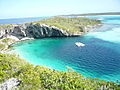
Long Island is surrounded by small bays and inlets, including the large New Found Harbour west of Deadman's Cay, at approximately the midsection of the island. There are also smaller islands off-shore, including Sandy Cay.
History
Some writers identify Long Island as the site of one of
The original Loyalists were mainly from
Settlements
Clarence Town, located in the south-central portion of the island, has a population 86 people.[4] Nearby Deadman's Cay (pop. 328) is the major settlement at the centre of the island and is home to Deadman's Cay Airport, which offers flights daily to Nassau and is the island's largest and busiest airport.
Mangrove Bush (pop. 142) is the home of the island's boatbuilding trade, while Hamilton's (pop. 196) is noted for its extensive cave system that is partially open for tours. Between these settlements is Petty's (pop. 69) known for its small Greek influence and a "fish-house" which helps support the local fishing industry.
Other settlements include Roses (or Roses Settlement),[7] Scrub Hill, Simms, and Burnt Ground. Most of the island's settlements are named after the families that first settled them. As a result, many (but not all) are named in the possessive form. The settlement of the Gray family, for example, is known as Gray's.
One main
Economy and tourism
Part of the
Due to the generally inhospitable soil of the Bahamas, much of the farming done on Long Island is in the
Tourist opportunities include sailing, fishing, scuba diving, snorkelling and relaxing on beaches. Cape Santa Maria Beach, located at Seymour's, is frequently ranked as one of the most beautiful beaches in the world. Most tourists charter an airplane or take a commercial flight from Exuma International Airport at George Town, Exuma or Nassau. International flights offered by Locair were planned which would have marked the return of regular international flights in over ten years; however, Locair is no longer in business.
Airports
The island has two airports, Deadman's Cay Airport which is served by Bahamasair and other local air carriers and Stella Maris Airport which also has local air carrier service.
Stella Maris airport was designed and built by Jack Henry Cordery who was engaged by Stella Maris Estate Company in 1967 when he emigrated from England to take the job of Estate Development Manager. He also developed the Marina and built roads. He died on Long Island in 1968 and is buried at Burnt Ground.
-
 Windward shore of Long Island, The Bahamas.
 -
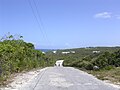 Road on Long Island, The Bahamas.
 -
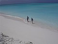 Lee shore beach on Long Island, The Bahamas.
 -
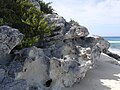 Holocene eolianite on Long Island, The Bahamas.
 -
 Columbus Monument on Long Island, The Bahamas.
 -
 The Dean's Blue Hole.


See also
- Bahama Banks
- Geography of the Bahamas
- History of the Bahamas
- List of islands of the Bahamas
- Lucayan Archipelago
- Out Islands
- Voyages of Christopher Columbus
References
- ^ "Census population and housing" (PDF). Bahamas Gov. Retrieved 17 April 2023.
- ^ "Department of Statistics of the Bahamas" (PDF). bahamas.gov.bs. Retrieved 30 March 2022.
- ^ a b "Long Island, Island of the Bahamas". The Islands of the Bahamas. Retrieved 18 November 2013.
- ^ a b LONG ISLAND POPULATION BY SETTLEMENT AND TOTAL NUMBER OF OCCUPIED DWELLINGS: 2010 CENSUS - Bahamas Department of Statistics
- ISSN 2816-7015.
- ^ Wilcomb E. Washburn, "Landfall Controversy" in The Christopher Columbus Encyclopedia, Vol. 1 (ed. Silvio A. Bedin: Simon & Schuster, 1992).
- ^ "Roses, Bahamas, The Page". Falling Rain. Falling Rain Genomics, Inc. 27 February 2015. Archived from the original on 23 October 2015. Retrieved 22 January 2017.
External links
| Authority control databases: Geographic |
|---|