
Long Sault Parkway
 Long Sault Parkway highlighted in red | |
| Route information | |
| Maintained by the Long Sault | |
| Location | |
| Country | Canada |
| Province | Ontario |
| Highway system | |
|
| |
The Long Sault Parkway is a group of eleven islands west of Cornwall in the Canadian province of Ontario, as well as the name of the 10.1-kilometre (6.3 mi) scenic parkway connecting them. The islands, which include two public beaches and three campgrounds, were created by the flooding of the Long Sault rapids during construction of the St. Lawrence Seaway. The parkway, the islands, and their amenities are maintained by the St. Lawrence Parks Commission.
The parkway is located between the towns of
Route description

The Long Sault Parkway is a 10.1-kilometre (6.3 mi) route that interconnects eleven islands that lie in
These islands—the former hilltops of inundated farmland[5]—comprise, from west to east, McLaren Island, Woodlands Island, Fraser Island, Hoople Island, Dickinson Island, Heriot Island, Vankoughnet Island, Phillpotts Island, Macdonnell Island, and Mille Roches Island, which itself connects to Snetsinger Island by footbridge. While the parkway, the islands, and their amenities are maintained by the St. Lawrence Parks Commission, Moulinette Island, which connects to Mille Roches Island by road, is not part of the Long Sault Parkway.[3][6]Beginning immediately east of Ingleside, the Long Sault Parkway branches south from Stormont, Dundas and Glengarry (SDG) County Road 2 and passes a parkway information booth, with the Ingleside Sewage Treatment Plant located on the southeast corner.[2][7] A causeway and a short bridge cross over to McLaren Island, named after Rev. Narcisse McLaren, founder of the local Camp Kagama. The parkway curves east and provides access to the McLaren Campground before crossing a small swamp to Woodlands Island, which is named after the displaced community of Woodlands and is host to both a beach and a campground. Causeways carry the parkway east to Fraser Island, named after explorer Simon Fraser, and Hoople Island, named for one of the original settlers of the area. The latter contains a nature trail as well as a boat launch. Another causeway connects Hoople and Dickinson Islands.[2][3][8]

Dickinson Island, named after the inundated village of
The final island on the Long Sault Parkway itself is Mille Roches Island, named for the inundated village of Mille Roches. In addition to a beach and campground, two islands are connected to Mille Roches Island: Snetsigner Island, honouring local merchant and politician John Goodall Snetsinger, which is connected by footbridge; and Moulinette Island, in remembrance of the inundated village of Moulinette. The latter is connected to Mille Roches Island by road; it features private residences and is not part of the Long Sault Parkway.[6] The parkway continues north, crossing a causeway and bridge to the mainland, where it passes a parkway information booth before ending at SDG County Road 2 at Long Sault; SDG County Road 35 (Moulinette Road) continues north into the town.[2][8]
The Long Sault Parkway is considered one of the most scenic drives in Ontario. According to James Stoness of SunCruiser Travellers magazine, "[a]lthough only 11 kms long, the Long Sault Parkway excels in its scenic beauty of the St. Lawrence River."[5] Northern Ontario Travel magazine included the parkway in their list of the Top 30 motorcycle roads in Ontario.[9] In describing the parkway, The Globe and Mail noted, "Think Florida Keys on a smaller scale, but better."[10] Ultimate Ontario remarked that it "isn't just one of the best drives in Ontario, it’s also one of the province's most unique places,"[11] while The Wedge described it as "an oasis unlike any other."[12]
Islands
Listed from west to east:[3][6]
- MacLaren Island
- Woodlands Island
- Fraser Island
- Hoople Island
- Dickinson Island
- Heriot Island
- Vankoughnet Island
- Phillpotts Island
- Macdonnell Island
- Snetsinger Island
- Mille Roches Island
History

The Long Sault Parkway was created as a direct result of the building of the Moses-Saunders Power Dam and the St. Lawrence Seaway in the 1950s.[13] The Seaway was a massive undertaking of both the Canadian and US governments that involved the "removal" of the Long Sault rapids by raising the water level approximately 26 metres (85 ft).[14][15] Plans and small projects to tame the Long Sault, which straddled the border between the two countries, had been commonplace since the 1890s, with the International Joint Commission (IJC) being formed to deal with the bilateral process. However, continued stalling by the American Senate and Congress through the 1930s and 1940s resulted in Canada announcing in 1951 that it would proceed alone with the construction of a dam at Cornwall to harness power from the St. Lawrence River, as well as an expanded canal entirely within its borders. Shortly after, America ceased its opposition and joined the project, with approvals granted over the next several years by Congress.[16] On June 7, 1954, the U.S. Supreme Court upheld the approvals, officially removing the final obstacle to construction.[17] Ontario Hydro would lead the project, while the IJC would coordinate the cross-border work.[13]
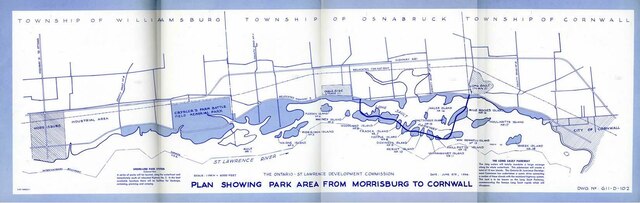
On August 10, 1954, prime minister Louis St. Laurent, Ontario premier Leslie Frost, New York governor Thomas E. Dewey and various officials gathered at the now inundated village of Maple Grove. There they set off a dynamite charge in place of the usual ceremonial sod-turning.[18] Ontario Hydro set forth to relocate residents of the 58,000 acres (235 km2) of land that would be flooded, and move some structures to one of two new town sites—Ingleside or Long Sault—or the Upper Canada Village. As well as displacing 6,500 people and submerging 10 communities,[16] the project uprooted the Akwesasne First Nations and washed away the site of the Battle of Crysler's Farm; the former would not reach a settlement until 50 years later in 2008,[19] while the latter saw a monument installed at Upper Canada Village.[20][21] The Ontario-St. Lawrence Development Commission was formed in 1955 to develop the parkland and amenities along the future shoreline;[22] all land west of Cornwall to Iroquois, below an elevation of 250 feet (80 m), was purchased.[16]
Construction of the C$1.5 million Long Sault Parkway was announced on March 1, 1956,[23] and began in June.[24] McNamara Construction graded the future causeways while Davey Construction built the bridges.[25][26] As a result of this dry construction, the three bridges carrying the parkway stood crossing empty fields as Ontario Hydro began to clear the 20,000 acres (81 km2) of land that would be flooded in Ontario in 1957.[27] On June 26, 1957, the Department of Mines released names for the future islands along the parkway, with each chosen to commemorate early settlers or communities lost to the project.[28]
Inundation Day, when the flooding would begin, was set for July 1, 1958. At 8 am EDT, 30 tons of dynamite was detonated, knocking holes in the cofferdam holding back the St. Lawrence River at Long Sault.[16] Water slowly but visibly crept up through the now-cleared farmlands and forests of the area for the next three days, ending July 4.[29] However, the Long Sault Parkway and the amenities along it were not complete by that time.[30] The road itself opened in November 1958,[1] while various beaches and campgrounds opened by the following summer.[31]
Major intersections
The following table lists locations along the Long Sault Parkway.[2] The entire route is located in the township of South Stormont, within the United Counties of Stormont, Dundas and Glengarry.[32]
| Location | km | mi | Destinations | Notes |
|---|---|---|---|---|
Brockville | ||||
| McLaren Island | 1.0 | 0.62 | McLaren Campground | |
| Woodlands Island | 2.4 | 1.5 | Woodlands Island Campground Woodlands Beach | |
| Hoople Island | 4.0 | 2.5 | Hoople Island Campsites | Parking for Chipmunk Nature Trail and Butternut Nature Trail |
| Macdonnell Island | 6.7 | 4.2 | Lock 21 Campsites | |
| Mille Roches Island | 8.2 | 5.1 | Mille Roches Campground | Pedestrian access to Snetsinger Island |
| 8.9 | 5.5 | Moulinette Island Causeway Street | ||
County Road 2 east – Cornwall | ||||
| 1.000 mi = 1.609 km; 1.000 km = 0.621 mi | ||||
See also
- The Lost Villages
References
- ^ ProQuest 1288820291. Retrieved April 21, 2021.
- ^ a b c d e f Google (April 13, 2021). "Long Sault Parkway – Length and Route" (Map). Google Maps. Google. Retrieved April 13, 2021.
- ^ a b c d Chemin de Long Sault Parkway (PDF) (Map). St. Lawrence Parks Commission. 2014. Retrieved April 16, 2021.
- ^ a b Environment & Climate Change Canada. "Map of Lake St. Lawrence" (Map). International Joint Commission. Retrieved April 16, 2021.
- ^ a b Stoness, James (January 15, 2017). "Drive the Long Sault Parkway". SunCruiser. Retrieved April 14, 2021.
- ^ ISBN 978-0814340400.
- ^ "Sanitary Sewage". Township of South Stormont. Retrieved April 16, 2021.
- ^ a b c The Islands of the Long Sault Parkway (mural). Ingleside, Ontario: St. Lawrence Parks Commission. Retrieved April 14, 2021.
- ^ Taplay, Kimberlee Anna (June 28, 2017). "Return to the Long Sault Parkway". Northern Ontario Travel. Retrieved April 16, 2021.
- ^ Vaughan, Michael (July 6, 2013). "A Gem of a Road in Ontario That's Worth the Detour". The Globe and Mail. Retrieved April 16, 2021.
- ^ Wagar, Kevin (May 7, 2020). "7 Breathtaking Drives in Ontario". Ultimate Ontario. Retrieved April 16, 2021.
- ^ Maggie M. (July 30, 2018). "Necklace of Pearls : Long Sault Astonishes". The Wedge. Retrieved April 16, 2021.
- ^ ProQuest 241178312. Retrieved April 16, 2021.
- hdl:2027/mdp.39015023109906. Retrieved April 16, 2021 – via Hathi Trust.)
{{cite book}}: CS1 maint: location missing publisher (link - ^ "The Great Lakes-St. Lawrence River System". Fisheries and Oceans Canada. August 2, 2019. Retrieved April 17, 2021.
- ^ a b c d Raymo, Denise A. (June 29, 2008). "Submerged". Press-Republican. Clinton, Essex and Franklin Counties, New York. Retrieved April 16, 2021.
- ^ Suydam, H. R. (July 19, 1958). "Long Rumbling Blast Opens a New Age". National Post. Vol. 52, no. 29. pp. 57–58. Retrieved April 20, 2021 – via Newspapers.com.
- ^ Swanson, Frank (August 10, 1954). "Power Project: Dynamite Blasts Launch Big Work". The Ottawa Citizen. Vol. 112, no. 35. p. 1. Retrieved April 20, 2021 – via Newspapers.com.
- ^ Akwesasne Mohawks settle with OPG on Saunders Dam, Association of Power Producers of Ontario, October 2008, retrieved April 20, 2021
- ^ "Crysler Farm: Pioneer Village Planned For New Memorial Park". The Ottawa Citizen. April 30, 1957. p. 7. Retrieved April 21, 2021 – via Newspapers.com.
- ^ "Learn about Battle of Crysler's Farm". Upper Canada Village. Archived from the original on April 20, 2021. Retrieved April 20, 2021.
- ^ Stewart, Burns (June 10, 1958). "Many in Seaway Valley Feel Park Action Slow". The Ottawa Journal. Vol. 73, no. 153. p. 17. Retrieved April 21, 2021 – via Newspapers.com.
- ^ "Long Sault Parkway Under Way This Year". The Ottawa Journal. Vol. 71, no. 70. March 1, 1956. p. 1. Retrieved April 20, 2021 – via Newspapers.com.
- ProQuest 1291250368. Retrieved April 16, 2021.
- ^ "New Scenic Causeway to Link Seaway Isles". The Ottawa Citizen. Vol. 113, no. 266. May 11, 1956. p. 42. Retrieved April 20, 2021 – via Newspapers.com.
- ^ Lynch, Charles (August 11, 1956). "Men, Machines Carve New Look". The Ottawa Journal. Vol. 71, no. 206. p. 13. Retrieved April 20, 2021 – via Newspapers.com.
- ^ Lynch, Charles (July 20, 1957). "Crysler's Farm New Site For Old Homes". The Ottawa Journal. Vol. 72, no. 188. p. 28. Retrieved April 20, 2021 – via Newspapers.com.
- ProQuest 1314027729. Retrieved April 16, 2021.
- ^ "PM at the Seaway Front Tops "International Day"". The Ottawa Journal. Vol. 116, no. 6. July 4, 1958. p. 19. Retrieved April 21, 2021 – via Newspapers.com.
- ^ "History Past, Present". National Post. Vol. 52, no. 29. July 19, 1958. p. 44. Retrieved April 21, 2021 – via Newspapers.com.
- ^ Hamilton, Mary (August 15, 1959). "Vacation Wonderland Found in the Seaway Valley". The Ottawa Citizen. Vol. 117, no. 41. p. 17. Retrieved April 21, 2021 – via Newspapers.com.
- ^ Township of South Stormont (PDF) (Map). 1:100,000. Cartography by Transportation and Planning Services. The United Counties of Stormont, Dundas and Glengarry. 2018. Retrieved July 10, 2021.