
Luang Namtha province
Luang Namtha province
ແຂວງ ຫລວງນໍ້າທາ | |
|---|---|
UTC+7 (ICT) | |
| ISO 3166 code | LA-LM |
| HDI (2018) | 0.576[1] medium · 7th |
Luang Namtha (
The province contains the
History
The history of Luang Namtha province is traced to inhabitants who lived there about 6,000 years ago, evidenced by archaeological finds of stone implements discovered from the Nam Jook River Valley in Vieng Phoukha. The
In 1890, the
After France withdrew from Indochina in the late-1950s, the Houa Thas were in conflict with the US-supported Royal Lao Army against Pathet Lao forces, and from 6 May 1962 the area was under Pathet Lao control. At this time the province was given its present name. The territory between Houei Xay and Vieng Phoukha, known as Houa Khong province, was royalist-controlled until the Lao People's Democratic Republic was established in 1975. From 1975 to 1983 Houa Khong and Luang Namtha were a single province and subsequently divided into Luang Namtha and Bokeo provinces.[2]
The capital of the province, Luang Namtha, had to be shifted in 1976 to a higher ground, by about 7 km, as the original city was not only prone to floods, but was also substantially destroyed during the
Geography
Luang Namtha province
The Mekong River (Nam Khong) marks the northwest border of the province. Three large rivers, the
Protected areas
The Nam Ha National Biodiversity Conservation Area (NBCA) has dense forest covering 90% of the area.
The Nam Ha
-
 Pha Yeung Waterfalls, Nam Ha NBCA
 -
 Kao Rao Caves, Nam Ha NBCA


Administrative divisions
The province is made up of the following five districts:[3][12]
| Map | Code | Name | Lao script | Population (2015) |
|---|---|---|---|---|

| ||||
| 3-01 | Luang Namtha | ເມືອງຫຼວງນໍ້າທາ | 54,089 | |
| 3-02 | Muang Sing | ເມືອງສີງ | 39,287 | |
| 3-03 | Long
|
ເມືອງລອງ | 34,630 | |
| 3-04 | Viengphoukha
|
ເມືອງວຽງພູຄາ | 23,928 | |
| 3-05 | Na Le
|
ເມືອງນາແລ | 23,819 |
Demographics
The population of the province as of the 2015 census was 175,753 persons.[13] The ethnic groups reported were the Khamu, Akha (Eko), Hmong, Yao (Ioumien) and Lanetene. Lowland Lao people, Tai Lue, Thai Neua and Thai Dam reside in villages just outside the Nam Ha National Biodiversity Conservation Area close to the town of Muang Sing.[3]
-
 Akha people
 -
 Lanten people
 -
 Mien people
 -
 Thai Dampeople


.jpg)

Economy
The province is one of the main
-
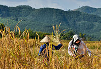 Farmers harvesting rice
 -
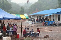
 Morning market, Muang Sing
 -
 Sale of bamboo sticks with glutinous rice
 -
 Border crossing with China


Transport
Road
The
Rail
The Boten–Vientiane railway, which parallels Route 13, serves the province.
Air
The
Landmarks
There are some 20 temples in Muang Sing. Of note is Wat Sing Jai or Wat Xieng Jai, behind the Muangsing Guest House. The monastery, painted in hues reminiscent of the Caribbean, has a museum, but because its items are of high local value, it is closed to visitors for fear of theft.[20] Another major temple is Wat Namkeo. The wihan in the town are typically multi-tiered, roofed buildings typical of northern Laos, but most houses have corrugated metal roofs and wooden beams, reflecting the poverty of the area. The Buddhas, however, are golden, and typically have large long earlobes, commonly seen in Xishuangbanna, China, and the Shan State of Burma.
Luang Namtha Museum, also known as Luang Namtha Provincial Museum, is in the capital city of Luang Namtha. Largely an anthropological museum, it contains numerous items related to local peoples such as ethnic clothing,
-
 That Luang Namtha
 -
 Wat Xieng Jai
 -
 Wat Xieng Jai interior
 -
 Wat Nam Keo Luang


Villages
References
- ^ "Sub-national HDI - Area Database - Global Data Lab". hdi.globaldatalab.org. Retrieved 2018-09-13.
- ^ a b c "History of Luang Namtha". Luang Namtha Tourism Organization. Archived from the original on 9 January 2012. Retrieved 9 December 2012.
- ^ a b c d e f g h The Lao National Tourism Administration. "National Protected Area System – Ecotourism Laos". Ecotourism Laos. GMS Sustainable Tourism Development Project in Lao PDR. Archived from the original on 19 September 2012. Retrieved 1 December 2012.
- ^ "Luang Namtha". Lonely Planet. Retrieved 9 December 2012.
- ^ "Regions". Lao Tourism Organization. Archived from the original on 11 January 2013. Retrieved 7 January 2013.
- ^ "Luangnamtha Province". Lao Tourism Organization. Archived from the original on 9 January 2013. Retrieved 1 December 2012.
- ^ Maps (Map). Google Maps.
- ^ "Namha". Official website of Ecotourism Organization. Archived from the original on 7 June 2013. Retrieved 10 December 2012.
- ^ a b c "Nam Ha NBCA (NHA; 2)". Official Website of GMS Sustainable Tourism Development Project in Lao PDR. Archived from the original on 7 June 2013. Retrieved 6 December 2012.
- ^ "Nam Ha Ecotourism Project" (PDF). UNDP Equator Initiative. Archived from the original (PDF) on 24 September 2015. Retrieved 27 November 2014.
- ^ "Important Bird Areas factsheet: Nam Ha". BirdLife International. 2012. Retrieved 6 December 2012.[not specific enough to verify]
- ^ "Provinces of Laos". Statoids.com. Retrieved 1 November 2012.
- ^ "Results of Population and Housing Census 2015" (PDF). Lao Statistics Bureau. Retrieved 1 May 2020.
- ISBN 978-1-4527-9182-1. Retrieved 6 December 2012.
- ^ "Lu Welcome to Luang Namtha, Northern of Laos". Luang Namtha Tourism Organization. Archived from the original on 21 February 2012. Retrieved 9 December 2012.
- ^ Bociaga, Robert (5 March 2020). "Chinese investment upheavals anger Laos' indigenous tribes". Nikkei Asian Review. Retrieved 23 March 2020.
- ^ "Heavy rainfall easily crack R3, a new regional highway". Archived from the original on 2013-06-28. Retrieved 2013-06-25.
- ^ "R3 to be crucial land link". Archived from the original on 2013-06-28. Retrieved 2013-06-25.
- ^ What are the current assistance projects extended by NEDA to the neighboring countries? Which types of projects are they?
- ISBN 978-1-85828-905-2. Retrieved 23 January 2012.
- ^ DK Travel Guides 2011, p. 180.
- ^ "Luang Namtha Museum". Lonely Planet/BBC Worldwide. Retrieved 20 July 2012.[permanent dead link]
General references
- DK Travel Guides (1 June 2011). DK Eyewitness Travel Guide: Cambodia & Laos. Dorling Kindersley Limited. p. 180. ISBN 978-1-4053-4985-7.
- Geological Survey (U S ) (25 October 2010). Minerals Yearbook: Area Reports: International 2008: Asia and the Pacific. Government Printing Office. pp. 14–. ISBN 978-1-4113-2964-5.
External links
- Photos of Luang Namtha province
- Ecotourism in Laos
- Map of Luang Nam Tha province
- Wildlife Conservation Society – Nam Ha National Protected Area Project
- Tourism as a Tool for Development (PDF-file)
Places adjacent to Luang Namtha province | ||||||||||||||||
|---|---|---|---|---|---|---|---|---|---|---|---|---|---|---|---|---|
| ||||||||||||||||
| Prefecture | ||
|---|---|---|
| Province | ||
| International | |
|---|---|
| National | |
| Geographic | |