
Luzerne County, Pennsylvania
Luzerne County | |
|---|---|
 Seal | |
 Topographical map of Luzerne County, Pennsylvania | |
 Location of Luzerne County in Pennsylvania | |
| Country | United States |
| State | |
Chevalier de la Luzerne | |
| County seat | Wilkes-Barre |
| Largest city | Wilkes-Barre |
| Government | |
| • Type | Council–manager |
| • Council | |
| • 570/272 | |
| Website | www |
Luzerne County is a
On September 25, 1786, Luzerne County was formed from part of
The county gained prominence in the 19th and 20th centuries as an active anthracite
History
The Luzerne County Historical Society maintains the storehouse for the collective memory of Luzerne County and its environs. It records and interprets the history, traditions, events, people, and cultures that have directed and molded life within the region.[5]
18th century


Long an area occupied by indigenous peoples, by the 1700s the
The British colonies of Pennsylvania and Connecticut both claimed the Wyoming Valley as their own. King Charles II of England had granted the land to the Connecticut Colony in 1662, but also to William Penn (the founder of Pennsylvania) in 1681. In 1769, Yankee settlers from Connecticut returned to the valley and founded the town of Wilkes-Barre. However, they were not alone. Pennsylvanian settlers (Pennamites) were also in the region.
Armed bands of Pennamites harassed the Connecticut settlers in what is known as the
On June 30, 1778,
Meanwhile, the Patriot militia assembled at Forty Fort. On July 3, a column of roughly 375 men, including a company of soldiers from the Continental Army, marched from the fort under the command of Lieutenant Colonel Zebulon Butler and Colonel Nathan Denison. Butler's Rangers, with the assistance of about 500 Native American allies, mostly Seneca, ambushed the approaching Americans. In the end, nearly 300 Wyoming Valley Patriots were killed in what is commonly known as the Wyoming Massacre.[7] Today, in the Borough of Wyoming, a monument marks the gravesite of the victims from the battle.[8]
The next day Colonel Denison surrendered Forty Fort along with several other posts. Widespread looting and burning of buildings occurred throughout the Wyoming Valley subsequent to this capitulation, but non-combatants were not harmed.[7] Most of the inhabitants, however, fled across the Pocono Mountains to Stroudsburg and Easton, or down the Susquehanna River to Sunbury.
In September 1778, American Colonel Thomas Hartley took partial revenge for the Wyoming defeat. He and his 200 soldiers burned a number of Delaware villages along the Susquehanna River. The following year, Major General John Sullivan would lead several thousand men in a scorched-earth campaign against the Iroquois nations in central and western New York.[7]
Two years later, in September 1780, reports of Iroquois and Loyalist activity in the region resulted in a detachment of 41 Patriot militia (from Northampton County) being sent to investigate. The detachment made it as far north as present-day Conyngham when they were ambushed by a party of Seneca and Loyalists. Ten men were killed in what is now known as the Sugarloaf Massacre.[9]
Post-Revolutionary War
The American Revolutionary War ended three years later (in 1783) with the signing of the Treaty of Paris. Great Britain finally recognized the sovereignty of the United States of America. The land dispute between Pennsylvania and Connecticut continued after the war. Connecticut established its own county (by the name of Westmoreland) in the Wyoming Valley. However, Pennsylvania insisted that they owned the land. The Congress of the Confederation was asked to resolve the matter. With the Trenton Decree, on December 30, 1782, the confederation government officially decided that the region belonged to Pennsylvania; the Wyoming Valley became part of Northumberland County.
Pennsylvania ruled that the Connecticut settlers (Yankees) were not citizens of the Commonwealth. Therefore, they could not vote and were ordered to give up their property claims. In May 1784, armed men from Pennsylvania force-marched the Connecticut settlers away from the valley. By November, the Yankees returned with a greater force. They captured and destroyed Fort Dickinson in Wilkes-Barre. With that victory, a new state (which was separate from both Connecticut and Pennsylvania) was proposed. The new state was to be named Westmoreland.
To ensure that they didn't lose the land, the Commonwealth of Pennsylvania worked out a compromise with the Connecticut (Yankee) settlers. The Yankee settlers would be allowed to become citizens of Pennsylvania and their property claims would be restored (as existing prior to the Decree of Trenton). As part of the compromise, Pennsylvania would establish a new county in Northeastern Pennsylvania. The Yankees agreed to the terms.[10]
On September 25, 1786, the
In the following years, elections were held, the courts were established, a courthouse was constructed, and a government was formed. In 1787, Lord Butler was elected the first sheriff of Luzerne County. A board of commissioners was also assembled to manage the county government. Some of the first county commissioners included Jesse Fell, Alexander Johnson, John Phillips, John Jenkins, and Thomas Wright (from 1794 to 1796).[11]
The population of the new county grew rapidly with new migrants. In 1790, fewer than 2,000 people resided within the Wyoming Valley. By 1800, the number of residents increased to nearly 13,000.[12]
19th century


The county gained prominence in the 19th century as an active
As the mining industry grew, a large region north of the Wyoming Valley, close to the Pennsylvania border with New York state, sought independence from Luzerne County. On February 21, 1810, the counties of Bradford, originally called Ontario, and Susquehanna were created from parts of Luzerne County. The two counties were officially formed in 1812.[13][14] Thirty years later, on April 4, 1842, Wyoming County — the region in and around present-day Tunkhannock — was also formed from a section of Luzerne County.[15]
The County of Luzerne witnessed a population boom as a result of the growing coal mining industry. Carbondale, with a population of nearly 5,000 residents, was incorporated as a city on March 15, 1851.[16] Scranton, with a population of nearly 35,000, was incorporated as a city on April 23, 1866.[17] And Wilkes-Barre, with a population of just over 10,000, was incorporated as a city in 1871.[18] By 1875, anthracite coal from Luzerne County alone represented half the anthracite produced in the Commonwealth of Pennsylvania.[12]
Since 1839, the people in and around the cities of Scranton and Carbondale sought independence from Luzerne County. Wilkes-Barre was determined to preserve the integrity of the county; it did not want to lose its assets in the region. Decades later, in the 1870s, residents of the proposed territory were allowed to vote for independent status. Voters favored a new county by a proportion of 6 to 1, with Scranton residents providing considerable support. Lackawanna County was finally created from a portion of Luzerne County in 1878.[19]
Even through Luzerne County lost a vital region (the coal mining cities of Scranton and Carbondale), its boroughs and townships continued to grow.
With an increasing population and the build-up of industry in the region, tragedies became more frequent in the second half of the 19th century. Sixteen people were killed – largely in factories – when a devastating
Towards the end of the 19th century, labor unrest and union activity intensified in the region. Miners protested poor working conditions and unfair pay. This revved up tensions throughout the county. One of the most notable and deadly confrontations occurred on September 10, 1897 (near Hazleton). Luzerne County Sheriff James Martin formed a
-
 Wyoming Valley in the 1860s
 -
 Wilkes-Barre in 1872
 -
 Hazleton in 1884
 -
 Pittston in 1892

.jpg)
.jpg)

20th century


.jpg)
At the beginning of the 20th century, Luzerne County was in the midst of an economic boom. Industry, which included manufacturing and coal mining, drew thousands of immigrants (mostly from Europe) to the region. However, there were several drawbacks to the industrial boom. Labor unrest, mining accidents, and
Also, in the early 1900s, the anthracite coal mining industry – and its extensive use of child labor – was one of the industries targeted by the
Despite the better working conditions, industrial accidents were still commonplace. On December 6, 1915, an
Regardless of the industrial setbacks, the region continued to grow economically. In 1906, construction began on a new
Railroad accidents were common throughout the United States in the 1800s and 1900s. In 1934, the right arm of
As the United States entered the age of mass air transportation, Scranton and Wilkes-Barre, the two largest cities in
In 1941, John B. McDade, president of the Heidelberg Coal Company and father of Congressman Joseph M. McDade, donated 122 acres on which part of the airport now sits. Most of the land was previously owned by various coal companies. By 1945, the two counties entered into a legal agreement to co-sponsor and operate the airport. Between 1945 and 1947, construction of the Wilkes-Barre/Scranton International Airport took place in and around Pittston Township. Today, the airport is known as the "Gateway to Northeastern Pennsylvania and the Pocono Mountains." It is the fifth busiest airport in Pennsylvania.
By the mid-20th century, anthracite production was declining at a steady rate. Consumers were gradually switching from coal to other forms of energy (e.g., oil, natural gas, and electricity). The
The Wyoming Valley witnessed historical flooding from the Susquehanna River in the past. In June 1972, Hurricane Agnes devastated much of the Eastern Seaboard (including Pennsylvania). The Susquehanna River rose to 40.9 feet and breached the levees of several communities in the Wyoming Valley. In Wilkes-Barre, hundreds were trapped in their homes; nearly nine feet of water inundated Public Square. At the historic cemetery in Forty Fort, 2,000 caskets were washed away, leaving body parts on porches, roofs, and in basements. In Luzerne County alone, 25,000 homes and businesses were either damaged or destroyed. Losses in the county totaled $1 billion.[35]
Luzerne County's economy was hit hard with the collapse of the mining industry and the devastating Agnes flood. To make matters worse, factories throughout the county were shutting down. They could not compete with lower labor costs elsewhere. By the end of the 20th century, Luzerne County was in the midst of a recession.
Following the Agnes flood (from the 1980s to 2000), two notable tragedies occurred in Luzerne County. The first took place on September 25, 1982, when
21st century


Many factories and coal mines were long since closed by the turn of the 21st century. Like most regions in the Rust Belt, Luzerne County witnessed population loss and urban decay over many decades beginning in the mid-20th century. Luzerne County in particular had reached the apex of its population around 1930. However, despite continuing population loss in recent years, the economy has grown moderately; warehousing has replaced manufacturing as the main industry.[38]
In the late 2000s, several scandals related to public corruption,
In May 2009, voters approved the creation of a government study commission. The commission proposed and wrote a home rule charter for Luzerne County. On November 2, 2010, the voters of Luzerne County held a referendum on the question of home rule. A total of 51,413 (55.25%) voted in favor of home rule, while another 41,639 (44.75%) voted against the move.[41] The home rule charter would eliminate the positions of the three county commissioners; they would be replaced by an eleven-member county council (who will appoint and work alongside a county manager). This referendum "starts a new chapter in Luzerne County history," remarked James Haggerty, the chairman of the commission that wrote and proposed the charter. The first election for the new government was scheduled for 2011 – which ended up becoming an eventful year for Luzerne County.
From March to June of that year, the Borough of Duryea received national attention for its role in the landmark Supreme Court case Borough of Duryea v. Guarnieri, in which the court stated that "a government employer's allegedly retaliatory actions against an employee do not give rise to liability under the Petition Clause unless the employee's petition relates to a matter of public concern."[42]
The second major event occurred in September 2011, when Luzerne County witnessed historical flooding from Tropical Storm Lee. The Susquehanna River reached a record high of 42.6 feet (13.0 meters) in Wilkes-Barre. The river topped the 40.9-foot (12.5-meter) level in flooding caused by Hurricane Agnes in 1972. However, unlike 1972, the levee system in Wilkes-Barre and several other communities held. Those municipalities without a levee system witnessed severe flooding.[43][44][45]
The first general election for Luzerne County Council was held on November 8, making it the third and final consequential event of 2011. In the end, six Democrats, four Republicans, and one independent politician were elected.
The home rule charter took effect on January 2, 2012. The Luzerne County
During the 2019 county council election, Republicans secured a majority on the county's governing board for the first time since 1989.[50]
Geography


According to the
Luzerne County consists of 76 independently governing
The
The Susquehanna River is the largest river in the county. There are several islands located within the river; for example, Scovell Island (near Pittston), Monocanock Island (near Wyoming), and Richard Island (near Wilkes-Barre). The Susquehanna drains most of the county (including Bowman Creek, Huntington Creek, the Lackawanna River, Nescopeck Creek, Solomon Creek, and many other streams). The Lehigh River, which forms part of Luzerne County's southeastern border, drains the easternmost region. Dozens of lakes and ponds are also scattered throughout the county (e.g., Harveys Lake, Lake Jean, Lake Louise, and Long Pond).
Luzerne County consists of several urban areas. The first is a contiguous quilt-work of former anthracite coal mining communities (including the cities of Pittston, Wilkes-Barre, and
State parks and forests
- There are four state parks in Luzerne County:
- Frances Slocum State Park (northern Luzerne County)
- Lehigh Gorge State Park (eastern Luzerne County)
- Nescopeck State Park (southern Luzerne County)
- Ricketts Glen State Park (western Luzerne County)
- There is only one state forest in Luzerne County:
- Moon Lake Park and Seven Tubs Recreation Area
- Other recreational areas:
Adjacent counties
- Carbon County (southeast)
- Columbia County (west)
- Lackawanna County (northeast)
- Monroe County (east)
- Schuylkill County (south)
- Sullivan County (northwest)
- Wyoming County (north)
-
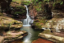 Adams Falls, Ricketts Glen State Park
 -
 Grand View Trail, Ricketts Glen State Park
 -
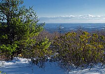
 Hayfields, Ricketts Glen State Park
 -
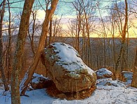 Summit of Mount Yeager, Nescopeck State Park
_(8213883793).jpg)
.jpg)
.jpg)

Climate

Luzerne County has a humid continental climate (Köppen climate classification Dfa/mostly Dfb) with four distinct seasons. Winters are cold with a January average of 25.8 °F (−3.4 °C).[55] The surrounding mountains have an influence on the climate (which includes both precipitation and temperature). This results in a wide array of weather conditions throughout the county.[56] On average, temperatures below 0 °F (−17.8 °C) are infrequent, occurring three days per year, and there are 36 days where the maximum temperature remains below 32 °F (0.0 °C).[56] In the Wilkes-Barre area, the average annual snowfall is 46.2 inches (117 cm) during the winter (in which severe snowstorms are rare).[56] However, when snowstorms do occur, they can disrupt normal routines for several days.[56]
Summers are warm with a July average of 71.4 °F (21.9 °C).[55] In an average summer, temperatures exceeding 90 °F (32.2 °C) occur on nine days and can occasionally exceed 100 °F (37.8 °C).[57] Spring and fall are unpredictable, with temperatures ranging from cold to warm (although they are usually mild). On average, Wilkes-Barre receives 38.2 inches (970 mm) of precipitation each year, which is relatively evenly distributed throughout the year (though the summer months receive more precipitation).[57]
Extreme temperatures range from −21 °F (−29.4 °C) on January 21, 1994, to 103 °F (39.4 °C) on July 9, 1936.[57] The hardiness zone is 6b in most lower areas except near the Susquehanna and Lackawanna Rivers where it is 7a, and it is 6a in higher areas.[58] Wilkes-Barre averages 2,303 hours of sunshine per year, ranging from a low of 96 hours in December (or 33% of possible sunshine) to 286 hours in July (or 62% of possible sunshine). Despite being at the south end of the county, Hazleton's temperatures average lower than those of the Wyoming Valley due to its elevation.
| Month | Jan | Feb | Mar | Apr | May | Jun | Jul | Aug | Sep | Oct | Nov | Dec | Year |
|---|---|---|---|---|---|---|---|---|---|---|---|---|---|
| Record high °F (°C) | 69 (21) |
76 (24) |
85 (29) |
93 (34) |
93 (34) |
99 (37) |
103 (39) |
102 (39) |
100 (38) |
91 (33) |
81 (27) |
71 (22) |
103 (39) |
| Mean maximum °F (°C) | 57.7 (14.3) |
57.0 (13.9) |
68.0 (20.0) |
81.3 (27.4) |
88.0 (31.1) |
90.5 (32.5) |
92.8 (33.8) |
90.5 (32.5) |
87.6 (30.9) |
78.6 (25.9) |
69.1 (20.6) |
59.6 (15.3) |
94.3 (34.6) |
| Mean daily maximum °F (°C) | 35.7 (2.1) |
38.8 (3.8) |
47.6 (8.7) |
61.1 (16.2) |
72.2 (22.3) |
79.9 (26.6) |
84.6 (29.2) |
82.4 (28.0) |
75.1 (23.9) |
63.1 (17.3) |
51.2 (10.7) |
40.3 (4.6) |
61.0 (16.1) |
| Daily mean °F (°C) | 28.0 (−2.2) |
30.3 (−0.9) |
38.3 (3.5) |
50.2 (10.1) |
60.9 (16.1) |
69.0 (20.6) |
73.7 (23.2) |
71.8 (22.1) |
64.6 (18.1) |
53.2 (11.8) |
42.7 (5.9) |
33.3 (0.7) |
51.3 (10.7) |
| Mean daily minimum °F (°C) | 20.3 (−6.5) |
21.9 (−5.6) |
28.9 (−1.7) |
39.3 (4.1) |
49.6 (9.8) |
58.1 (14.5) |
62.7 (17.1) |
61.1 (16.2) |
54.0 (12.2) |
43.3 (6.3) |
34.3 (1.3) |
26.3 (−3.2) |
41.7 (5.4) |
| Mean minimum °F (°C) | 0.6 (−17.4) |
3.6 (−15.8) |
11.0 (−11.7) |
24.7 (−4.1) |
34.7 (1.5) |
44.1 (6.7) |
50.9 (10.5) |
48.8 (9.3) |
38.7 (3.7) |
28.7 (−1.8) |
18.0 (−7.8) |
9.1 (−12.7) |
−1.6 (−18.7) |
| Record low °F (°C) | −21 (−29) |
−19 (−28) |
−4 (−20) |
8 (−13) |
27 (−3) |
34 (1) |
43 (6) |
38 (3) |
29 (−2) |
19 (−7) |
5 (−15) |
−13 (−25) |
−21 (−29) |
| Average precipitation inches (mm) | 2.59 (66) |
2.07 (53) |
2.77 (70) |
3.26 (83) |
3.26 (83) |
3.80 (97) |
3.61 (92) |
3.85 (98) |
4.15 (105) |
3.71 (94) |
2.85 (72) |
2.80 (71) |
38.72 (983) |
| Average snowfall inches (cm) | 11.7 (30) |
10.9 (28) |
10.1 (26) |
0.8 (2.0) |
0.0 (0.0) |
0.0 (0.0) |
0.0 (0.0) |
0.0 (0.0) |
0.0 (0.0) |
0.7 (1.8) |
3.2 (8.1) |
7.7 (20) |
45.1 (115) |
| Average precipitation days (≥ 0.01 in) | 12.6 | 11.4 | 11.8 | 12.2 | 12.9 | 12.9 | 11.1 | 11.1 | 10.0 | 10.7 | 10.3 | 12.1 | 139.1 |
| Average snowy days (≥ 0.1 in) | 8.7 | 8.4 | 4.8 | 1.0 | 0.0 | 0.0 | 0.0 | 0.0 | 0.0 | 0.3 | 1.7 | 6.3 | 31.2 |
| Average relative humidity (%)
|
70.1 | 67.5 | 63.3 | 60.4 | 64.6 | 70.5 | 71.1 | 73.8 | 75.2 | 71.6 | 71.8 | 72.5 | 69.4 |
| Average dew point °F (°C) | 16.2 (−8.8) |
17.2 (−8.2) |
24.4 (−4.2) |
33.1 (0.6) |
45.3 (7.4) |
55.9 (13.3) |
60.4 (15.8) |
59.9 (15.5) |
53.4 (11.9) |
41.4 (5.2) |
32.2 (0.1) |
22.3 (−5.4) |
38.5 (3.6) |
| Mean monthly sunshine hours | 130.3 | 143.7 | 185.7 | 210.5 | 246.9 | 269.7 | 285.7 | 257.2 | 200.2 | 173.3 | 104.3 | 95.9 | 2,303.4 |
| Percent possible sunshine | 44 | 48 | 50 | 53 | 55 | 60 | 62 | 60 | 54 | 50 | 35 | 33 | 52 |
| Source: | |||||||||||||
| Climate data for Hazleton, Luzerne County, PA | |||||||||||||
|---|---|---|---|---|---|---|---|---|---|---|---|---|---|
| Month | Jan | Feb | Mar | Apr | May | Jun | Jul | Aug | Sep | Oct | Nov | Dec | Year |
| Mean daily maximum °F (°C) | 31.9 (−0.1) |
35.4 (1.9) |
44.1 (6.7) |
57.4 (14.1) |
68.1 (20.1) |
75.8 (24.3) |
79.7 (26.5) |
77.5 (25.3) |
70.8 (21.6) |
59.7 (15.4) |
47.8 (8.8) |
36.3 (2.4) |
57.1 (13.9) |
| Daily mean °F (°C) | 23.8 (−4.6) |
26.9 (−2.8) |
34.4 (1.3) |
46.7 (8.2) |
57.3 (14.1) |
65.6 (18.7) |
70.0 (21.1) |
68.1 (20.1) |
61.1 (16.2) |
49.8 (9.9) |
39.5 (4.2) |
28.5 (−1.9) |
47.7 (8.7) |
| Mean daily minimum °F (°C) | 15.7 (−9.1) |
18.3 (−7.6) |
24.7 (−4.1) |
36.0 (2.2) |
46.6 (8.1) |
55.4 (13.0) |
60.4 (15.8) |
58.6 (14.8) |
51.4 (10.8) |
39.9 (4.4) |
31.3 (−0.4) |
20.7 (−6.3) |
38.3 (3.5) |
| Average precipitation inches (mm) | 3.20 (81) |
2.90 (74) |
3.55 (90) |
4.43 (113) |
4.47 (114) |
5.19 (132) |
4.43 (113) |
4.34 (110) |
4.78 (121) |
4.49 (114) |
4.24 (108) |
3.71 (94) |
49.73 (1,263) |
| Average relative humidity (%)
|
74.6 | 69.0 | 64.9 | 61.1 | 64.7 | 73.2 | 73.7 | 77.0 | 77.7 | 74.2 | 73.4 | 75.7 | 71.6 |
| Source: PRISM Climate Group[61] | |||||||||||||
Ecology
Sceptridium dissectum is a common fern in the county.[62]
Demographics

| Census | Pop. | Note | %± |
|---|---|---|---|
| 1790 | 4,892 | — | |
| 1800 | 12,839 | 162.4% | |
| 1810 | 18,109 | 41.0% | |
| 1820 | 20,027 | 10.6% | |
| 1830 | 27,379 | 36.7% | |
| 1840 | 44,006 | 60.7% | |
| 1850 | 56,072 | 27.4% | |
| 1860 | 90,244 | 60.9% | |
| 1870 | 160,915 | 78.3% | |
| 1880 | 133,065 | −17.3% | |
| 1890 | 201,203 | 51.2% | |
| 1900 | 257,121 | 27.8% | |
| 1910 | 343,186 | 33.5% | |
| 1920 | 390,991 | 13.9% | |
| 1930 | 445,109 | 13.8% | |
| 1940 | 441,518 | −0.8% | |
| 1950 | 392,241 | −11.2% | |
| 1960 | 346,972 | −11.5% | |
| 1970 | 342,301 | −1.3% | |
| 1980 | 343,079 | 0.2% | |
| 1990 | 328,149 | −4.4% | |
| 2000 | 319,255 | −2.7% | |
| 2010 | 320,918 | 0.5% | |
| 2020 | 325,594 | 1.5% | |
| Sources:[63][64][65][66] | |||
As of the
According to the
According to the census of 2000, there were 319,250 people, 130,687 households, and 84,293 families residing in the county. The population density was 358 inhabitants per square mile (138 inhabitants/km2). There were 144,686 housing units at an average density of 162 units per square mile (63 units/km2). The
There were 130,687 households, out of which 48.80% were married couples living together. 11.50% had a female householder with no husband present. 35.50% were non-families. 31.30% of all households were made up of individuals. 16% of those age 65 years and older lived alone. The average household size was 2.34 and the average family size was 2.95.
In the county, the population consisted of 21% under the age of 18, 8.10% from 18 to 24, 27.20% from 25 to 44, 24% from 45 to 64, and 19.70% who were 65 years of age or older. The median age was 41 years. For every 100 females, there were 93 males. For every 100 females (age 18 and over), there were 89.50 males.
The median household income (in 2015 dollars) was $45,897. 15.1% of the population lives in poverty. 60.4% of those 16 years of age or older are in the civilian labor force. There are more
2020 Census
| Race | Num. | Perc. |
|---|---|---|
White (NH)
|
250,304 | 77% |
Black or African American (NH)
|
14,031 | 4.3% |
Native American (NH)
|
295 | 0.1% |
Asian (NH)
|
3,960 | 1.21% |
Pacific Islander (NH)
|
65 | 0.02% |
Other/Mixed (NH)
|
10,041 | 3.1% |
Latino
|
46,898 | 14.4% |
Languages
The two major languages spoken in Luzerne County are English and Spanish. 5.8% of the population speaks Spanish at home.[74]
Religion
59.27% of the people in Luzerne County are religious, meaning they affiliate with a religion. 43.77% are
Economy
Through 2019 the
Luzerne is both a productive farming county and a commuter location for nearby large cities.[83] As such farmland is often converted to other real estate uses, and the county has created the Luzerne Conservation District to encourage conservation.[83] The Luzerne CD runs the Farmland Preservation Program to encourage farmland to be set aside instead of turning it into construction and development.[83]
Garlic Mustard (
Government


Background
Luzerne County voters rejected home rule proposals in the past (once in 1974 and again in 2003). However, from 2008 to 2010, corruption plagued the county government. Three county judges, a county commissioner, a clerk of courts, a deputy chief clerk, and a director of human resources faced criminal charges. These events persuaded the voters of Luzerne County to adopt a new form of government. On Tuesday, November 2, 2010, a home rule charter was adopted by a margin of 51,413 to 41,639.[39][41]
The following year (in 2011), the first election for the new government was held. On Monday, January 2, 2012, the previous government (the board of county commissioners) was abolished and replaced with the new form of government (council–manager government). The first members of the Luzerne County Council were sworn in that same day. The council's highest-ranking officer is the chair; who is also the head of county government for ceremonial purposes. The first council chair was Jim Bobeck.[47] The assembly consists of eleven elected members. They appoint and work alongside a full-time manager. The manager oversees the county's day-to-day operations. The first manager was Robert Lawton.[49]
County Council
Luzerne County Council is the governing body of the county. The council meets at the Luzerne County Courthouse. There are eleven members on the assembly – seven Republicans and four Democrats. Each member is duly elected by the voters of the county. The chair is appointed by their fellow council members. The chair is both the highest-ranking officer on the council and the head of county government for ceremonial purposes.[46] He or she sets the agenda for the council and administers the meetings. When the group is not in session, the officer's duties often include acting as its representative to the outside world and its spokesperson. The current chair is John Lombardo.[86]
| Council member | Tenure | Party | Position |
|---|---|---|---|
| John Lombardo | 2022–present | Republican | Chair |
| Brian Thornton | 2022–present | Republican | Vice Chair |
| Patty Krushnowski | 2024–present | Democratic | |
| Kevin Lescavage | 2022–present | Republican | |
| Lee Ann McDermott | 2020–present | Republican | |
| Joanna Bryn Smith | 2024–present | Democratic | |
| Jimmy Sabatino | 2024–present | Democratic | |
| Chris R. Perry | 2018–present | Republican | |
| Brittany Stephenson | 2024–present | Democratic | |
| Harry Haas | 2012–2022,[88] 2024–present | Republican | |
| Gregory S. Wolovich | 2022–present | Republican |
| Chair | Tenure | Party | Notes | |
|---|---|---|---|---|
| 1 | Jim Bobeck | 2012 | Democratic | |
| 2 | Tim McGinley | 2012–2014 | Democratic | |
| 3 | Rick Morelli | 2014–2015 | Republican | |
| 4 | Linda McClosky Houck | 2015–2018 | Democratic | First female chair |
| 5 | Tim McGinley | 2018–2022 | Democratic | |
| 6 | Kendra Vough | 2022–2024 | Republican | |
| 7 | John Lombardo | 2024–present | Republican |
County Manager
The executive branch is headed by the Luzerne County Manager. The manager supervises the county's day-to-day operations. According to the home rule charter, the manager "shall serve at the pleasure of county council."[46] In other words, the council has the power to appoint and remove the manager.[89] Each ordinance, resolution, and policy established by county council should be faithfully executed by the county manager. The manager may make recommendations to the council; however, the manager does not have the authority to vote on or veto any legislation originating from the assembly.[46] The current county manager is Romilda P. Crocamo.[90]
Other county officials
- Controller: Walter L. Griffith, Jr.
- Director of Human Resources: Angela Gavlick
- District Attorney: Samuel Sanguedocle
- Chief Public Defender: Steven M. Greenwald
- Sheriff: Brian M. Szumski
-
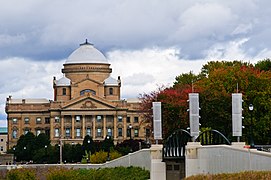
 Luzerne County Courthouse
 -
 Luzerne County Courthouse, October 2009
 -
 The Susquehanna River and the Wilkes-Barre skyline with the Luzerne County Courthouse in the background


Politics
| Year | Republican | Democratic | Third party | |||
|---|---|---|---|---|---|---|
| No. | % | No. | % | No. | % | |
| 2020 | 86,929 | 56.63% | 64,873 | 42.26% | 1,697 | 1.11% |
| 2016 | 78,688 | 57.90% | 52,451 | 38.60% | 4,762 | 3.50% |
| 2012 | 58,325 | 46.72% | 64,307 | 51.51% | 2,213 | 1.77% |
| 2008 | 61,127 | 44.96% | 72,492 | 53.32% | 2,349 | 1.73% |
| 2004 | 64,953 | 47.75% | 69,573 | 51.15% | 1,502 | 1.10% |
| 2000 | 52,328 | 43.76% | 62,199 | 52.01% | 5,059 | 4.23% |
| 1996 | 43,577 | 37.30% | 60,174 | 51.51% | 13,066 | 11.19% |
| 1992 | 49,285 | 38.76% | 56,623 | 44.53% | 21,238 | 16.70% |
| 1988 | 59,059 | 50.01% | 58,553 | 49.58% | 480 | 0.41% |
| 1984 | 69,169 | 53.50% | 58,482 | 45.23% | 1,640 | 1.27% |
| 1980 | 67,822 | 50.21% | 59,976 | 44.40% | 7,282 | 5.39% |
| 1976 | 60,058 | 44.16% | 74,655 | 54.89% | 1,296 | 0.95% |
| 1972 | 81,358 | 60.89% | 51,128 | 38.27% | 1,120 | 0.84% |
| 1968 | 57,044 | 39.79% | 79,040 | 55.13% | 7,296 | 5.09% |
| 1964 | 43,895 | 28.86% | 106,397 | 69.97% | 1,779 | 1.17% |
| 1960 | 70,711 | 40.58% | 102,998 | 59.10% | 562 | 0.32% |
| 1956 | 92,458 | 58.22% | 65,155 | 41.02% | 1,207 | 0.76% |
| 1952 | 88,967 | 54.83% | 72,579 | 44.73% | 715 | 0.44% |
| 1948 | 71,674 | 52.85% | 61,869 | 45.62% | 2,068 | 1.52% |
| 1944 | 67,984 | 47.81% | 73,674 | 51.81% | 541 | 0.38% |
| 1940 | 79,685 | 43.81% | 101,577 | 55.85% | 622 | 0.34% |
| 1936 | 81,572 | 43.26% | 105,008 | 55.68% | 1,997 | 1.06% |
| 1932 | 52,672 | 45.44% | 60,975 | 52.60% | 2,281 | 1.97% |
| 1928 | 67,872 | 48.00% | 73,319 | 51.85% | 220 | 0.16% |
| 1924 | 46,475 | 53.18% | 20,472 | 23.42% | 20,449 | 23.40% |
| 1920 | 49,419 | 65.39% | 23,473 | 31.06% | 2,683 | 3.55% |
| 1916 | 25,348 | 53.73% | 19,999 | 42.39% | 1,832 | 3.88% |
| 1912 | 4,970 | 12.02% | 13,461 | 32.56% | 22,907 | 55.41% |
| 1908 | 24,594 | 56.24% | 17,379 | 39.74% | 1,760 | 4.02% |
| 1904 | 27,809 | 64.83% | 13,518 | 31.51% | 1,568 | 3.66% |
| 1900 | 21,793 | 54.87% | 16,470 | 41.47% | 1,454 | 3.66% |
| 1896 | 22,718 | 55.08% | 17,305 | 41.95% | 1,225 | 2.97% |
| 1892 | 14,118 | 45.21% | 15,734 | 50.38% | 1,377 | 4.41% |
| 1888 | 15,543 | 49.25% | 15,218 | 48.22% | 797 | 2.53% |
| 1884 | 12,859 | 47.18% | 13,806 | 50.65% | 592 | 2.17% |
| 1880 | 11,028 | 45.94% | 12,575 | 52.38% | 403 | 1.68% |
As of January 8, 2024, there are 196,835 registered voters in Luzerne County.[92]
- Democratic: 87,400 (44.40%)
- Republican: 82,974 (42.15%)
- Independent: 20,337 (10.33%)
- Third Party: 6,124 (3.11%)
The Democratic Party has been historically dominant in county-level politics. However, during the 2019 Luzerne County Council election, Republicans – for the first time – secured a majority on the council, the county's governing body. Thomas Baldino, professor emeritus of political science at Wilkes University, suspected that the 2019 Luzerne County Council election results were due to the trending Republican preference in the county (mostly due to then-President Trump's popularity in the region).[93][94]
During presidential elections, the county is considered a bellwether of the state. Until 2020, it had voted for the presidential candidate who carried Pennsylvania in every election since 1936. Luzerne County has leaned Democratic in past presidential elections; however, that trend has changed in recent years. During the 2000 U.S. presidential election, Democrat Al Gore won 52% of the vote to Republican George W. Bush's 44%. In 2004, it was much closer, with Democrat John Kerry winning 51% to Republican George Bush's 48%. Democrat Barack Obama carried the county twice (once in 2008, and again in 2012). During the 2016 presidential election, the county swung dramatically to Republican Donald Trump, who won it with 58% of the vote, the largest margin since President Richard Nixon in 1972. It was the first time a Republican presidential candidate carried the county since 1988. Trump won the county almost as easily in 2020.
In recent years, Luzerne County has witnessed mixed results in U.S. Senate elections. In 2000, 2004, 2016, 2018, and 2022, the Republican candidates for the Senate won the county. However, Democratic Senate candidates carried the county in 2006 (with 60.6% of the vote), 2010, and 2012.
Democratic candidates for
Near the end of the
United States Senate
United States House of Representatives
- Matthew Cartwright, D, Pennsylvania's 8th congressional district
- Dan Meuser, R, Pennsylvania's 9th congressional district
State Senate
- Lisa Baker, R, Pennsylvania's 20th Senatorial District
- Marty Flynn, D, Pennsylvania's 22nd Senatorial District
- Lynda Schlegel Culver, R, Pennsylvania's 27th Senatorial District
- Dave Argall, R, Pennsylvania's 29th Senatorial District
State House of Representatives
- Dane Watro, R, Pennsylvania's 116th Representative District
- Mike Cabell, R, Pennsylvania's 117th Representative District
- Jim Haddock, D, Pennsylvania's 118th Representative District
- Alec Ryncavage, R, Pennsylvania's 119th Representative District
- Aaron Kaufer, R, Pennsylvania's 120th Representative District
- Eddie Day Pashinski, D, Pennsylvania's 121st Representative District
Public safety

There are many
The police provide full-time protection to its citizens, visitors, businesses, and public property. Most departments are headed by a
After Luzerne County adopted a home rule charter, the office of sheriff became an appointed position (and was no longer an elected one). The Pennsylvania State Police also have a presence in the county. Troop P operates out of the northern half of Luzerne County and is headquartered in Hanover Township as PSP Wilkes-Barre. Troop P also has a barracks in Salem Township—PSP Shickshinny. Troop N operates out of the southern portion of the county and is headquartered in West Hazleton as PSP Hazleton.
Healthcare
.jpg)
Hospitals
- First Hospital in Kingston, an affiliate of Commonwealth Health (psychiatric care only)
- Wilkes BarreHospital (GSWB), formerly Mercy Hospital
- Geisinger Wyoming Valley Medical Center (GWV) in Plains Township
- Hazleton General Hospital (Lehigh Valley Health Network)
- Nanticoke Special Care Hospital, an affiliate of Commonwealth Health
- VA Medical Center in Wilkes-Barre
- Wilkes-Barre General Hospital, an affiliate of Commonwealth Health
Education


Public school districts
- Berwick Area School District (also in Columbia County)
- Crestwood School District
- Dallas School District
- Greater Nanticoke Area School District
- Hanover Area School District
- Hazleton Area School District (also in Carbon and Schuylkill Counties)
- Lake-Lehman School District (also in Wyoming County)
- Northwest Area School District
- Pittston Area School District
- Wilkes-Barre Area School District
- Wyoming Area School District (also in Wyoming County)
- Wyoming Valley West School District
Charter schools
- Bear Creek Community Charter School, Bear Creek Township
Public vocational technical schools
Private schools
- Graham Academy, Kingston
- Lackawanna County; it serves Luzerne County residents
- Holy Redeemer High School, Wilkes-Barre
- Jenny Lynn Ferraro Academy, Kingston
- Milford E. Barnes Junior School, Wilkes-Barre
- MMI Preparatory School, Freeland
- New Story School, Wyoming
- Wilkes-Barre Academy, Wilkes-Barre
- Wyoming Seminary, Forty Fort and Kingston[99]
Colleges and universities
- Geisinger Commonwealth School of Medicine, Wilkes-Barre
- King's College, Wilkes-Barre
- Luzerne County Community College, Nanticoke
- McCann School of Business & Technology, Wilkes-Barre
- Misericordia University, Dallas
- Penn State Hazleton, Hazleton
- Penn State Wilkes-Barre, Lehman Township
- Wilkes University, Wilkes-Barre
Libraries
The Luzerne County Library System includes the following locations:[100][101]
- Back Mountain Memorial Library, Back Mountain
- Hazleton Area Public Library, Hazleton
- Hoyt Library, Kingston
- Marian Sutherland Kirby Library, Mountain Top
- Mill Memorial Library, Nanticoke
- Osterhout Free Library, Wilkes-Barre
- Pittston Memorial Library, Pittston
- Plymouth Public Library, Plymouth
- West Pittston Library, West Pittston
- Wyoming Free Library, Wyoming
Culture


Local attractions
- Bear Creek Village Historic District, Bear Creek Village
- Bittenbender Covered Bridge, Huntington Township
- Eckley Miners' Village, Foster Township
- F.M. Kirby Center for the Performing Arts, Wilkes-Barre[102]
- Giants Despair Hillclimb, Laurel Run
- Kingston Armory, Kingston
- Little Theatre of Wilkes-Barre, Wilkes-Barre[103]
- Luzerne County Museum, Wilkes-Barre[104]
- Wilkes-Barre Township
- Mohegan Sun at Pocono Downs, Plains Township
- Public Square, Wilkes-Barre
- River Street Historic District, Wilkes-Barre
- Stegmaier Brewery, Wilkes-Barre
- Swetland Homestead, Wyoming
- Wilkes-Barre station, Wilkes-Barre
- Wyoming Monument, Wyoming
- Wyoming Valley Mall, Wilkes-Barre Township
Media
The
Sports
| Team name | League | Sport | Venue |
|---|---|---|---|
| Wilkes-Barre/Scranton Penguins | AHL | Ice Hockey
|
Mohegan Sun Arena |
| Scranton/Wilkes-Barre RailRiders | IL | Baseball | PNC Field |
Transportation

Highways
Railroads
- Canadian Pacific Railway (CP)
- Delaware and Hudson Railway (DH)
- Luzerne and Susquehanna Railway (LS)
- Norfolk Southern Railway (NS)
- North Shore Railroad (NSHR)
- Reading Blue Mountain and Northern Railroad (RBMN)
Airports
- Hazleton Municipal Airport
- Wilkes-Barre/Scranton International Airport
- Wilkes-Barre Wyoming Valley Airport
-
 Interstate 80 in southern Luzerne County
 -
 Specialist Dale J. Kridlo Bridge (U.S. Route 11)
 -
 North Cross Valley Expressway (PA 309)
 -


.jpg)


Communities


Luzerne County contains the second highest number of independently governing municipalities in the state of Pennsylvania, with 76; only Allegheny County has more.[107] Under Pennsylvania law, there are four types of incorporated municipalities: cities, boroughs, townships, and, in the case of Bloomsburg, towns. The following cities, boroughs, and townships are located in Luzerne County:
Cities
- Hazleton
- Nanticoke
- Pittston
- Wilkes-Barre (county seat)
Boroughs
- Ashley
- Avoca
- Bear Creek Village
- Conyngham
- Courtdale
- Dallas
- Dupont
- Duryea
- Edwardsville
- Exeter
- Forty Fort
- Freeland
- Harveys Lake
- Hughestown
- Jeddo
- Kingston
- Laflin
- Larksville
- Laurel Run
- Luzerne
- Nescopeck
- New Columbus
- Nuangola
- Penn Lake Park
- Plymouth
- Pringle
- Shickshinny
- Sugar Notch
- Swoyersville
- Warrior Run
- West Hazleton
- West Pittston
- West Wyoming
- White Haven
- Wyoming
- Yatesville
Townships
Census-designated places
Census-designated places are geographical areas designated by the U.S. Census Bureau for the purposes of compiling demographic data. They are not actual jurisdictions under Pennsylvania law.
- Beech Mountain Lakes
- Browntown
- Chase
- East Berwick
- Georgetown
- Glen Lyon
- Harleigh
- Hickory Hills
- Hilldale
- Hudson
- Inkerman
- Lattimer
- Misericordia University
- Mocanaqua
- Mountain Top
- Nuremberg
- Pardeesville
- Pikes Creek
- Plains
- Shavertown
- Sheatown
- Silkworth
- Trucksville
- Upper Exeter
- Wanamie
- West Nanticoke
- Weston
Other places
- Alden
- Back Mountain
- Beach Haven
- Breslau
- Cambra
- Cranberry
- Drifton
- Drums
- Ebervale
- Glen Summit Springs
- Greater Pittston
- Harveyville
- Humboldt
- Hunlock Creek
- Huntington Mills
- Japan
- Kis-Lyn
- Koonsville
- Korn Krest
- Kunkle
- Lehman
- Milnesville
- Moosehead
- Mossville
- Mountain Grove
- Old Boston
- Port Griffith
- Rock Glen
- Saint Johns
- Sandy Run
- Suscon
- Sweet Valley
- Sybertsville
- Tomhicken
- Wapwallopen
- Waterton
- Zenith
Population ranking
The population ranking of the following table is based on the 2010 census of Luzerne County.[108]
† county seat
| Rank | City/Borough/Township | Municipal type | Population (2010 census) |
|---|---|---|---|
| 1 | † Wilkes-Barre | City | 41,498 |
| 2 | Hazleton | City | 25,340 |
| 3 | Kingston | Borough | 13,182 |
| 4 | Hanover Township | Township | 11,076 |
| 5 | Nanticoke | City | 10,465 |
| 6 | Plains Township | Township | 9,961 |
| 7 | Hazle Township
|
Township | 9,549 |
| 8 | Butler Township | Township | 9,221 |
| 9 | Dallas Township
|
Township | 8,994 |
| 10 | Pittston | City | 7,739 |
| 11 | Kingston Township
|
Township | 6,999 |
| 12 | Plymouth | Borough | 5,951 |
| 13 | Exeter | Borough | 5,652 |
| 14 | Wright Township | Township | 5,651 |
| 15 | Newport Township | Township | 5,374 |
| 16 | Swoyersville | Borough | 5,062 |
| 17 | Duryea | Borough | 4,917 |
| 18 | West Pittston | Borough | 4,868 |
| 19 | Edwardsville | Borough | 4,816 |
| 20 | Jackson Township | Township | 4,646 |
| 21 | West Hazleton | Borough | 4,594 |
| 22 | Fairview Township | Township | 4,520 |
| 23 | Larksville | Borough | 4,480 |
| 24 | Jenkins Township
|
Township | 4,442 |
| 25 | Salem Township | Township | 4,254 |
| 26 | Forty Fort | Borough | 4,214 |
| 27 | Sugarloaf Township | Township | 4,211 |
| 28 | Freeland | Borough | 3,531 |
| 29 | Lehman Township | Township | 3,508 |
| 30 | Foster Township | Township | 3,467 |
| 31 | Pittston Township | Township | 3,368 |
| 32 | Rice Township | Township | 3,335 |
| 33 | Wyoming | Borough | 3,073 |
| 34 | Wilkes-Barre Township
|
Township | 2,967 |
| 35 | Ross Township | Township | 2,937 |
| 36 | Luzerne | Borough | 2,845 |
| 37 | Dallas | Borough | 2,804 |
| 38 | Harveys Lake | Borough | 2,791 |
| 39 | Ashley | Borough | 2,790 |
| 40 | Bear Creek Township | Township | 2,774 |
| 41 | West Wyoming | Borough | 2,725 |
| 42 | Dupont | Borough | 2,711 |
| 43 | Avoca | Borough | 2,661 |
| 44 | Hunlock Township
|
Township | 2,443 |
| 45 | Exeter Township | Township | 2,378 |
| 46 | Huntington Township | Township | 2,244 |
| 47 | Dorrance Township
|
Township | 2,188 |
| 48 | Lake Township | Township | 2,049 |
| 49 | Union Township | Township | 2,042 |
| 50 | Black Creek Township
|
Township | 2,016 |
| 51 | Conyngham | Borough | 1,914 |
| 52 | Plymouth Township | Township | 1,812 |
| 53 | Franklin Township | Township | 1,757 |
| 54 | Nescopeck | Borough | 1,583 |
| 55 | Laflin | Borough | 1,487 |
| 56 | Conyngham Township | Township | 1,453 |
| 57 | Hughestown | Borough | 1,392 |
| 58 | Fairmount Township
|
Township | 1,276 |
| 59 | Hollenback Township
|
Township | 1,196 |
| 60 | Nescopeck Township | Township | 1,155 |
| 61 | Dennison Township
|
Township | 1,125 |
| 62 | Slocum Township | Township | 1,115 |
| 63 | White Haven | Borough | 1,097 |
| 64 | Sugar Notch | Borough | 989 |
| 65 | Pringle | Borough | 979 |
| 66 | Shickshinny | Borough | 838 |
| 67 | Courtdale | Borough | 732 |
| 68 | Nuangola | Borough | 679 |
| 69 | Yatesville | Borough | 607 |
| 70 | Warrior Run | Borough | 584 |
| 71 | Laurel Run | Borough | 500 |
| 72 | Buck Township
|
Township | 435 |
| 73 | Penn Lake Park | Borough | 308 |
| 74 | Bear Creek Village | Borough | 257 |
| 75 | New Columbus | Borough | 227 |
| 76 | Jeddo | Borough | 98 |
Notable people
See also
- Luzerne County Transportation Authority
- National Register of Historic Places listings in Luzerne County, Pennsylvania
- Pennamite–Yankee War
- USS Luzerne County
Notes
- ^ Mean monthly maxima and minima (i.e. the expected highest and lowest temperature readings at any point during the year or given month) calculated based on data at said location from 1991 to 2010.
- ^ Official records for Avoca/Wilkes-Barre–Scranton kept at downtown Scranton from January 1901 to 17 April 1955 and at Wilkes-Barre/Scranton International Airport since 18 April 1955.[59]
References
- ^ "Find a County". National Association of Counties. Retrieved June 7, 2011.
- ^ a b Tice, Joyce M. "History of Bradford County PA, 1770–1878 by David Craft – Chapter 9". www.joycetice.com.
- ^ a b "Wyoming County Historical Society". pawchs.org.
- ^ Davidson, Adam (July 6, 2016). "Blaming Trade and Voting Trump in the Rust Belt". The New York Times. Retrieved January 19, 2018.
- ^ "Home". February 5, 2007. Archived from the original on February 5, 2007.
{{cite web}}: CS1 maint: bot: original URL status unknown (link) - ^ Fisher, Sydney George (1896). The Making of Pennsylvania. Philadelphia, PA: J. B. Lippincott Company.
- ^ ISBN 9781594160134.
- ^ Jenkins, Steuben (July 3, 1878). Historical Address at the Wyoming Monument (Speech). 100th Anniversary of the Battle and Massacre of Wyoming. Retrieved July 2, 2013.
- ^ Verenna, Thomas (July 6, 2015). "Murder along the Creek: Taking a Closer Look at the Sugarloaf Massacre". Journal of the American Revolution. Retrieved February 26, 2023.
- ^ "Second Yankee-Pennamite War". Luzerne County. Archived from the original on March 27, 2013. Retrieved December 23, 2014.
- ^ "History of Luzerne County Pennsylvania 1893". Usgwarchives.net. Retrieved January 19, 2018.
- ^ a b c d "Luzerne County : History of Luzerne County". www.luzernecounty.org. Archived from the original on March 27, 2013. Retrieved April 11, 2017.
- ^ Bradford County History Archived July 27, 2011, at the Wayback Machine, Bradford County, Pennsylvania. Accessed August 21, 2007
- ^ "Township Incorporations, 1790 to 1853". Susquehanna County Historical Society. Archived from the original on June 23, 2015. Retrieved March 9, 2013.
- ^ "Wyoming County | WyomingHistory". Wycopa.org. Archived from the original on January 15, 2018. Retrieved January 19, 2018.
- ^ Hollister, Horace (1885). History of the Lackawanna Valley. Lippincott. p. 488.
- ^ David Craft (1891). History of Scranton, Penn: With Full Outline of the Natural Advantages, Accounts of the Indian Tribes, Early Settlements, Connecticut's Claim to the Wyoming Valley, the Trenton Decree, Down to the Present Time. H. W. Crew. pp. 18–. Retrieved March 19, 2013.
- ^ "History of Wilkes-Barre, Pennsylvania". u-s-history.com.
- ^ Henry C. Bradsby, History of Luzerne County, Pennsylvania, Volume 1, 1893, Pages 232–233
- ^ Administrator. "History – Life – Life". www.hazletoncity.org.
- ^ "Striking in the dark of night, the Wilkes-Barre tornado was a freak - The Washington Post". The Washington Post.
- ^ "August 19, 1890 Wilkes Barre Tornado".
- ^ Cheryl A. Kashuba (September 6, 2009). "Avondale mine disaster claimed 110 lives". The Times-Tribune. Retrieved April 23, 2010.
- ^ "Twin Shaft Disaster Marker". Hmdb.org. August 19, 2008. Retrieved July 21, 2009.
- ^ "GenDisasters ... Genealogy in Tragedy, Disasters, Fires, Floods – Events That Touched Our Ancestors' Lives". www.gendisasters.com. Archived from the original on November 21, 2008.
- ISBN 1-56000-764-8
- ^ Troncale, Anthony T. "About Lewis Wickes Hine". New York Public Library. Archived from the original on March 8, 2007. Retrieved May 22, 2007.
- ISBN 9780813741185, retrieved January 30, 2014
- ^ "New York Times "FLAME IN TUNNEL KILLS 84, BURNS 42: Spreads Like Blanket Over Miners."". June 6, 1919.
- ^ "National Historic Landmarks & National Register of Historic Places in Pennsylvania". CRGIS: Cultural Resources Geographic Information System. Archived from the original (Searchable database) on July 21, 2007. Retrieved January 15, 2018. Note: This includes Gary F. Lamont (n.d.). "National Register of Historic Places Inventory Nomination Form: Luzerne County Courthouse" (PDF). Retrieved March 13, 2012.
- ^ "history". www.nanticokecity.com. Archived from the original on March 3, 2018. Retrieved April 11, 2017.
- ^ Tyler, Gus (1995). Look for the Union Label: A History of the International Ladies' Garment Workers' Union. Armonk, NY: M. E. Sharpe.
- ^ Lavietes, Stuart (September 17, 2002). "Aaron Danzig, 89, Who Argued Landmark Case on Court Power". The New York Times.
Erie Railroad Co. v. Tompkins, the landmark 1938 Supreme Court case that limited the power of the federal courts
- ^ David Pencek (1998). "Knox Mine Disaster". Times Leader. Retrieved December 29, 2016.
- ^ Bill O'Boyle (June 22, 2009). "Agnes now a flood of memories". Times Leader. Archived from the original on January 2, 2014. Retrieved March 6, 2012.
- ^ "Banks named in 8 more murder indictments". The Reading Eagle. Associated Press. September 30, 1982. Retrieved March 26, 2011.
- ^ "CNN Transcript – WorldView: NTSB Begins Investigation Into Charter Plane Crash in Pennsylvania Which Killed All 19 Onboard – May 21, 2000". Cnn.com. May 21, 2000. Retrieved January 19, 2018.
- ^ Money By ADAM DAVIDSON (July 6, 2016). "Blaming Trade and Voting Trump in the Rust Belt – The New York Times". The New York Times. Retrieved January 19, 2018.
- ^ a b Voters say 'yes' to home rule – News. Standard Speaker (November 3, 2010). Retrieved on July 23, 2013.
- ^ Frank, Thomas (April 1, 2009). "Thomas Frank Says 'Kids for Cash' Incentivizes the Prison Industry". Wall Street Journal. Retrieved August 25, 2009.
- ^ a b "Election Results Archive". Luzerne County. Archived from the original on January 11, 2018. Retrieved January 19, 2018.
- Cornell University Law School. June 20, 2011. Retrieved August 26, 2013.
- ^ Mandatory Evacuation of Wyoming Valley by 4 p.m., Times-Leader, September 8, 2011
- ^ Eckert, Paul (September 9, 2011). "UPDATE 3-Pennsylvania hit by huge flooding, towns submerged". Reuters. Archived from the original on September 24, 2015. Retrieved July 1, 2017.
- ^ Luzerne officials issue mandatory evacuation in footprint of Agnes flood, Times Tribune, September 8, 2011
- ^ a b c d "Home Rule Charter". Luzerne County. Archived from the original on February 4, 2018. Retrieved March 2, 2018.
- ^ a b "Luzerne County Council members sworn in – The Times Leader reports". YouTube. January 2, 2012. Archived from the original on November 18, 2021. Retrieved February 22, 2017.
- ^ System Administrator (January 24, 2012). "Luzerne County's manager search – News – Citizens' Voice". Citizensvoice.com. Retrieved January 19, 2018.
- ^ a b "Luzerne County Manager Robert Lawton Resigns". pahomepage.com. November 26, 2015.
- ^ Buffer, Michael P. (November 7, 2019). "Voting Republican again preferred choice in county". The Citizens' Voice. Wilkes-Barre, Pennsylvania. Retrieved December 22, 2019.
- ^ "2010 Census Gazetteer Files". United States Census Bureau. August 22, 2012. Retrieved March 9, 2015.
- ^ "Pennsylvania County High Points". Peakbagger.com. November 1, 2004. Retrieved February 22, 2017.
- ^ "Living and Working Here - Lucerne County, Pennsylvania". Retrieved November 11, 2022.
- ^ Susquehanna Warrior Trail, PA – Google Maps. Maps.google.com (January 1, 1970). Retrieved on July 23, 2013.
- ^ a b c "Station: Wilkes-Barre INTL AP, PA". U.S. Climate Normals 2020: U.S. Monthly Climate Normals (1991–2020). National Oceanic and Atmospheric Administration. Retrieved June 24, 2021.
- ^ a b c d "Local Climatological Data–Annual Summary with Comparative Data: Wilkes–Barre/Scranton" (PDF). National Oceanic and Atmospheric Administration. Retrieved September 30, 2015.
- ^ a b c d "NowData – NOAA Online Weather Data". National Oceanic and Atmospheric Administration. Retrieved June 24, 2021.
- ^ "2023 USDA Plant Hardiness Zone Map | USDA Plant Hardiness Zone Map".
- ^ ThreadEx
- ^ "WMO Climate Normals for WILKES-BARRE-SCRANTON, PA 1961–1990". National Oceanic and Atmospheric Administration. Retrieved June 24, 2021.
- ^ "PRISM Climate Group, Oregon State University". www.prism.oregonstate.edu. Retrieved July 9, 2019.
- ^
- • Page, Christopher (2002), "Ecological strategies in fern evolution: a neopteridological overview", S2CID 88240195
- • Page, Christopher (2002), "Ecological strategies in fern evolution: a neopteridological overview",
- ^ "U.S. Decennial Census". United States Census Bureau. Retrieved March 9, 2015.
- ^ "Historical Census Browser". University of Virginia Library. Archived from the original on August 11, 2012. Retrieved March 9, 2015.
- ^ Forstall, Richard L., ed. (March 24, 1995). "Population of Counties by Decennial Census: 1900 to 1990". United States Census Bureau. Retrieved March 9, 2015.
- ^ "Census 2000 PHC-T-4. Ranking Tables for Counties: 1990 and 2000" (PDF). United States Census Bureau. April 2, 2001. Archived (PDF) from the original on October 9, 2022. Retrieved March 9, 2015.
- ^ "Population and Housing Unit Estimates". Retrieved March 26, 2020.
- ^ "2020 Census: Luzerne County". Retrieved February 3, 2022.
- ^ Census data, USA Today
- ^ US Census Bureau. ""Explore Census Data". Archived from the original on February 12, 2020. Retrieved April 4, 2020."Explore Census Data". Archived from the original on May 21, 2008. Retrieved April 4, 2020.http://factfinder.census.gov Archived May 21, 2008, at the Wayback Machine>.
- ^ "Luzerne County Demographics & Statistics â€" Employment, Education, Income Averages, Crime in Luzerne County â€" Point2 Homes". Point2homes.com. Retrieved February 22, 2017.
- ^ "Luzerne County Pennsylvania QuickFacts from the U.S. Census Bureau". Census.gov. Retrieved February 22, 2017.
- ^ "P2 HISPANIC OR LATINO, AND NOT HISPANIC OR LATINO BY RACE – 2020: DEC Redistricting Data (PL 94-171) – Luzerne County, Pennsylvania".
- ^ "Languages in Luzerne County, Pennsylvania (County)". Statistical Atlas. April 17, 2015. Retrieved February 22, 2017.
- ^ "Luzerne County, Pennsylvania Religion". Bestplaces.net. Retrieved February 22, 2017.
- ^ a b
"Luzerne County". Pennsylvania State University Extension. 2022.
- ^ "State and County Profiles - Pennsylvania - Luzerne County - Census of Agriculture". USDA, National Agricultural Statistics Service. 2017. Retrieved July 29, 2022.
- ^ "2017 Census - Volume 1, Chapter 1: State Level Data". United States Department of Agriculture National Agricultural Statistics Service (USDA NASS). 2017. Retrieved July 29, 2022.
- ^ PMID 32797186.
- ^ Luzerne County Master Gardener Program(Penn State Extension). 2020. Retrieved October 14, 2022.
- S2CID 252759037.
- ^ Harper, Jayson; Stone, William; Kelsey, Timothy; Kime, Lynn (2019). "Potential Economic Impact of the Spotted Lanternfly on Agriculture and Forestry in Pennsylvania". Center for Rural Pennsylvania, a legislative agency of the Pennsylvania General Assembly.
{{cite journal}}: Cite journal requires|journal=(help) - ^ a b c "Farmland Preservation Program". Luzerne Conservation District. Wilkes-Barre, Pennsylvania. 2022. Retrieved November 15, 2022.
- ^ a b Determinants of the invasion of garlic mustard (Alliaria petiolata, Brassicaceae) in northeastern Pennsylvania David M. Kunkel; Grace F. Chen Journal of the Pennsylvania Academy of Science (2020) 94 (1-2): 73–90. https://doi.org/10.5325/jpennacadscie.94.1-2.0073 Where Is Garlic Mustard? Understanding the Ecological Context for Invasions of Alliaria petiolata Vikki L Rodgers, Sara E Scanga, Mary Beth Kolozsvary, Danielle E Garneau, Jason S Kilgore, Laurel J Anderson, Kristine N Hopfensperger, Anna G Aguilera, Rebecca A Urban, Kevyn J Juneau BioScience, Volume 72, Issue 6, June 2022, Pages 521–537, https://doi.org/10.1093/biosci/biac012
- ^ "Eragrostis pilosa". Plant Atlas. University of South Florida Institute for Systematic Botany. 2022. Retrieved November 19, 2022.
- ^ https://www.timesleader.com/news/1641456/john-lombardo-is-new-luzerne-county-council-chair
- ^ "Luzerne County Council | Luzerne County, PA". Luzerne County. Retrieved January 28, 2024.
- ^ "Harry Haas running for Luzerne County Council | Luzerne County, PA".
- ^ Administrator, System (January 24, 2012). "Luzerne County's manager search". citizensvoice.com.
- ^ "County Manager". Luzerne County, PA | Official Website. Retrieved December 16, 2022.
- ^ David Leip. "Dave Leip's Atlas of U.S. Presidential Elections". Uselectionatlas.org. Retrieved January 19, 2018.
- ^ "Voter registration statistics by county".
- ^ "2 incumbents, 4 others win county council seats". November 6, 2019.
- ^ "Voting Republican again preferred choice in county". November 6, 2019.
- ^ The Guardian. Retrieved December 4, 2023.
- ^ Cohen, Marshall (September 24, 2020). "White House touts unusual Justice Department announcement about 'discarded' Trump ballots in Pennsylvania". CNN. Retrieved December 4, 2023.
- ^ "Luzerne County : Police and Fire Departments". www.luzernecounty.org. Archived from the original on September 21, 2017. Retrieved May 8, 2017.
- ^ "Definition of SHERIFF". www.merriam-webster.com. January 17, 2024.
- ^ Pennsylvania Department of Education (2011). "Licensed, Private Academic Schools in Pennsylvania". Archived from the original on April 29, 2011.
- ^ "Member Libraries | Luzerne County Library System". www.luzernelibraries.org. Retrieved January 25, 2018.
- ^ "Luzerne County : Library Locations". www.luzernecounty.org. Archived from the original on January 26, 2018. Retrieved January 25, 2018.
- ^ "The F.M. Kirby Center for the Performing Arts". Kirbycenter.org. Retrieved May 12, 2014.
- ^ "Little Theatre of Wilkes-Barre". Ltwb.org. Retrieved May 12, 2014.
- ^ Luzerne County Historical Society. "Welcome to the Luzerne County Historical Society website | NEPA Luzerne County Pennsylvania history". Luzernehistory.org. Retrieved May 12, 2014.
- ^ "Nielsen Local Television Market Universe Estimates" (PDF). Nielsen. Archived (PDF) from the original on October 9, 2022. Retrieved May 26, 2015.
- ^ "Wilkes Barre – Scranton Television Stations". Station Index. Retrieved August 29, 2011.
- ^ "Pennsylvania Municipalities Information". Pamunicipalitiesinfo.com. Archived from the original on April 1, 2022. Retrieved August 16, 2012.
- ^ "2010 Census". Census.gov. Retrieved February 22, 2017.
External links
- Official Luzerne County website
- "Luzerne County Library System". Archived from the original on February 12, 2008.
- Tournepa.com: Luzerne County Convention and Visitors Bureau
- The Luzerne Foundation — the county's Community Foundation.
- Luzerne County Community College website
Places adjacent to Luzerne County, Pennsylvania | ||||||||||||||||
|---|---|---|---|---|---|---|---|---|---|---|---|---|---|---|---|---|
| ||||||||||||||||

| International | |
|---|---|
| National | |
| Geographic | |
| Other | |