
Māngere Bridge (suburb)
Māngere Bridge | |
|---|---|
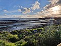
 Western part of the suburb seen from Māngere Mountain. | |
 | |
| Coordinates: 36°56′36″S 174°47′5″E / 36.94333°S 174.78472°E | |
| Country | New Zealand |
| City | Auckland |
| Local authority | Auckland Council |
| Electoral ward | Manukau ward |
| Local board | Māngere-Ōtāhuhu Local Board |
| Area | |
| • Land | 645 ha (1,594 acres) |
| Population (June 2023)[2] | |
| • Total | 11,680 |
| (Manukau Harbour) | Onehunga (Māngere Inlet) |
(Māngere Inlet) |
| (Manukau Harbour) |
|
Favona |
| (Manukau Harbour) | Māngere | Favona |
Māngere Bridge is a suburb of Auckland, New Zealand, under the local governance of the Auckland Council. Surrounded by the Manukau Harbour, the area is the most north-western suburb of South Auckland, and is connected to Onehunga in central Auckland by three bridges that cross the Māngere Inlet. Many features of the Auckland volcanic field are found in and around Māngere Bridge, including Māngere Mountain, a 106-metre-high (348 ft) feature in the centre of the suburb, and Māngere Lagoon, a volcanic tidal lagoon opposite Puketutu Island in the harbour. The suburb is also home to Ambury Regional Park, a working farm and nature sanctuary run by Auckland Council,[3] that connects to the Kiwi Esplanade and Watercare Coastal walkways.
After being inhabited for hundreds of years by
Māngere Bridge developed suburban housing in the 1950s and 1960s, experiencing growth helped by its proximity to Auckland Airport, which opened in 1966. After the closure of open-air wastewater-treatment ponds in the early 2000s, the part of the harbour surrounding Māngere Bridge underwent significant ecological restoration. The suburb is multicultural; many residents are large families, and the housing stock is dominated by brick-and-tile homes built in the 1960s and 1970s.[3] In 2019, the suburb name was officially gazetted as Māngere Bridge.[4]
History
Māori history

Most of the land around Māngere Bridge is formed from lava flows from Te Pane o Mataaho / Māngere Mountain.[5]: 20 Archaeological records date fishing activities in the area as far back as the 15th century.[6]: 10 The Ambury Regional Park and Māngere Lagoon areas have around 100 recorded archaeological sites, including stoneworks and shell middens.[6]: 5 The area closer to Māngere Mountain has fewer identified sites, likely as the result of modern developments destroying evidence of these.[6]: 5
In the early 18th century, Te Pane o Mataaho / Māngere Mountain was a major pā for the Waiohua, a confederacy of Tāmaki Māori iwi.[7] The mountain complex may have been home to thousands of people, with the mountain acting as a central place for rua (food storage pits).[8]: 63 Paramount chief Kiwi Tāmaki would stay at Māngere seasonally, when it was the time of year to hunt sharks in the Manukau Harbour.[9] In the early 1740s, Kiwi Tāmaki was slain in battle by the Te Taoū hapū of Ngāti Whātua.[10] After the battle, most Waiohua fled the region, although many of the remaining Waiohua warriors regrouped at Te Pane o Mataaho.[11] The warriors strew pipi shells around the base of the mountain to warn against attacks, but Te Taoū warriors covered the pipi shells with dogskin cloaks to muffle the sound, and raided the pā at dawn. An alternate name for the mountain, Te Ara Pueru ("the dogskin cloak path"), references this event.[11]
After the events of this war,
Colonial period and land confiscation
,_1853_-_Mangere_Bridge_cropped.jpg)
In the 1820s and early 1830s, the threat of Ngāpuhi raiders from the north during the Musket Wars caused most of the Tāmaki Makaurau area to become deserted.[13] During this period, a peace accord between Ngāpuhi and Waikato Tainui was reached through the marriage of Matire Toha, daughter of Ngāpuhi chief Rewa was married to Kati Takiwaru, the younger brother of Tainui chief Pōtatau Te Wherowhero, and they settled together on the slopes of Māngere Mountain.[8]: 67 Ngāti Whātua returned to the Māngere-Onehunga area by the mid-1830s,[13] re-establishing a pā on Māngere Mountain called Whakarongo.[14] In late 1837, members of Tainui iwi Ngāti Mahuta settled at Māngere Bridge, after receiving an offer from Ngāti Whātua to share land.[13]
On 20 March 1840, Ngāti Whātua chief Apihai Te Kawau signed the Treaty of Waitangi at Orua Bay on the Manukau Harbour,[15] inviting Lieutenant-Governor William Hobson to settle in Auckland, hoping this would protect the land and people living in Tāmaki Makaurau.[16] In the winter of 1840, Ngāti Whātua Ōrākei moved the majority of the iwi to the Waitematā Harbour, with most iwi members resettling to the Remuera-Ōrākei area, closer to the new European settlement at Waihorotiu (modern-day Auckland CBD). A smaller Ngāti Whātua presence remained at Māngere-Onehunga, as well as members of Te Uringutu.[17][18] In the late 1840s, Governor George Grey asked Pōtatau Te Wherowhero (then known as a powerful chief and negotiator, but later the first Māori King) to settle his people in the Māngere Bridge area to defend the township of Auckland, in an arrangement similar to the European Fencible Corps settlements on the outskirts of the Auckland township.[19]: 3 [20]: 39 Pōtatau Te Wherowhero and his people (known as the Māori Militia) settled near to the land where his brother Kati Takiwaru lived, an area of 190 hectares (480 acres) around the base of Māngere Mountain.[8]: 68 The Māngere Bridge area was divided into 81 single-acre and 81 two-acre lots by the colonial government.[19]: 3 In 1847, the first ferry service between Onehunga and Māngere Bridge was established by Mr Bradney, where passengers would raise a flag at Māngere Bridge to signal the ferry operator.[21]
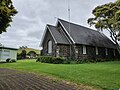
The 1850s were a prosperous time for the region. Māngere Bridge was settled by a mix of Waikato-Tainui, Ngāti Whatua, Waiohua-descendant tribes such as Te Ākitai Waiohua and a minority of European/Pākehā farmers.[8]: 68 Māori from the Manukau Harbour and Waikato areas would bring goods to sell or barter with the European population, including goods such as peaches, melons, fish and potatoes.[19]: 3 In 1858, Pōtatau Te Wherowhero relocated to Ngāruawāhia, with his role as tribal leader of the Māngere settlement taken up by Tāmati Ngāpora.[19]: 3 [22] In the late 1850s, the St James Anglican Church was constructed as a joint project between European settlers and the Ngāti Mahuta militia, using scoria taken from Māngere Mountain.[23]: 36 [24]
The prosperity was short-lived, as on 9 July 1863, due to fears of the Māori King Movement, Governor Grey proclaimed that all Māori living in the South Auckland area needed to swear loyalty to the Queen and give up their weapons. Most people refused due to strong links to Tainui, leaving for the south before the Government's
Opening of the bridge and dairy farming

Plans for a bridge spanning the Māngere Inlet began in 1866, when a company was formed to investigate a crossing between Māngere and Onehunga, funded by a grant provided by the Auckland provincial government.
From the late 1880s, Māngere Bridge was one of the largest dairy suppliers to the city of Auckland. In October 1887, Ambury and English Ltd opened a dairy factory in the area, supplying milk from the dairy farms (which includes modern day Ambury Regional Park, and farms along Wallace Road and Creamery Road)[27] to their stores on Karangahape Road and Ponsonby Road. The creamery closed in 1937, and in 1943 operations were sold to the New Zealand Co-operative Dairy Company.[28][8]: 68
Chinese market gardens and suburbanisation

In 1915, a new, wider bridge across the Manukau Harbour was opened, after the original was declared unsafe and closed the previous year.[29][21] The first Chinese New Zealanders arrived in the area in 1915,[23]: 11 and ten years later the first freehold land was sold to a Chinese buyer.[30] Between the 1920s and 1940s, a large proportion of the area was used for Chinese-owned and operated market gardens.[27] By 1954, over half of the registered market gardens in the Māngere-Onehunga area were run by Chinese families.[30] Other employers in the area included a quarry established at Taylor Road in the mid-1920s (running until 1963),[23]: 35 rope works,[23]: 11 and a dancehall and tearooms called the Oriental Rendezvous, which was built on the waterfront and became a regular fixture of Auckland nightlife until it burnt down in 1932.[31][32] In 1932, a water reservoir was constructed atop Māngere Mountain,[23]: 22 and in the late 1930s the area was electrified.[23]: 22
In the 1950s, the area changed from mostly rural to suburban, as Māngere Bridge was developed for housing, extending west past Seaforth Avenue in 1959.[23]: 23 The Māngere Bridge town centre began to develop in the 1950s and 1960s (mostly undeveloped until this time, due to the close proximity of the shops in Onehunga), during which the first banks were built in the suburb.[23]: 10, 18 In 1954, Māngere Bridge formed as a county town within the Manukau County Council, and in 1965 it became a suburb of the newly formed Manukau City.[23]: 9 In 1965, the Te Puea Memorial Marae was opened,[23]: 45 later becoming a temporary refuge to help combat growing homelessness in New Zealand.[33] The area saw significant increase in traffic after the opening of the Auckland Airport in 1966.[21]
Māngere sewage ponds, new bridges and the Southwestern Motorway

In 1960, the Manukau Sewage Purification Works (now Māngere Wastewater Treatment Plant) was opened,[34] using an algae-based system to process the waste for the majority of the Auckland region with oxidation ponds in the Manukau Harbour and Māngere Lagoon, extending outwards to Puketutu Island.[35][23]: 15–16 The Manukau Harbour site was chosen in 1954 to replace the Ōkahu Bay sewage tanks (the site of modern-day Kelly Tarlton's Sea Life Aquarium).[35] The Manukau Harbour became the preferred site after Dove-Myer Robinson lobbied against the planned Motukorea / Browns Island sewage plant.[36] The ponds caused degradation to the environment of the harbour, destruction of traditional fishing grounds at the Oruarangi Creek, strong odours and swarms of Chironomus zealandicus (New Zealand midge) in the surrounding areas.[34] The following year, the Māngere Residents' Protest Committee was formed to seek improvements or compensation.[34] The plant was upgraded in 1983, but odour and midge problems persisted in Māngere Bridge.[37] In the early 2000s the oxidation ponds were decommissioned and the treatment plant upgraded to use ultraviolet lamps to disinfect the sewage.[35][23]: 11 As a part of the pond closure process, work on the ecological restoration of the harbour and shoreline began, resulting in the construction of the Watercare Coastal Walkway and an increase in migratory wading birds returning to the harbour.[35]
In 1970, planning began for State Highway 20 (commonly known as the Southwestern Motorway), an additional motorway connecting the Auckland CBD to Auckland Airport through Mount Roskill and Onehunga.[38] Planning for this highway included a new motorway bridge to be built alongside the existing Māngere Bridge,[39] and for the far eastern section of the suburb to be bisected by the new motorway. Construction on the bridge began in the mid 1970s.[39] However, by May 1978, the construction halted when workers organised a labour strike over insufficient redundancy payments. The partially constructed bridge was picketed for a period of two and a half years, becoming the longest continuous labour strike in the history of New Zealand.[40] The bridge was opened in 1983,[41] and by 1984 State Highway 20 had extended south to Coronation Road, and to Massey Road by 1997.[41] In 2010, a parallel motorway bridge over the Māngere Inlet was constructed, doubling the number of lanes to eight.[41][42] The entire Western Ring Route project, connecting the Northwestern Motorway to the Southern Motorway was completed in 2017.[43]
In November 2018, the old Māngere Bridge was closed due to safety issues.[44] A new, curved, pedestrian and cycling bridge will open by late August 2022.[45] The proposals for the City Centre-to-Māngere light rail project involve a stop at Māngere Bridge,[46]: 18 [47] which may also involve a new crossing of the Māngere Inlet, separate to the Māngere Bridge pedestrian bridge and motorway bridges.[48]: 2 After the 2023 New Zealand general election, plans for light rail to Māngere were placed on hold.[49]
In 2019, the name of the suburb was officially gazetted as Māngere Bridge, adding a macron to the suburb's name.[4]
Demographics
Māngere Bridge covers 6.45 km2 (2.49 sq mi)[1] and had an estimated population of 11,680 as of June 2023,[2] with a population density of 1,811 people per km2.
| Year | Pop. | ±% p.a. |
|---|---|---|
| 2006 | 8,802 | — |
| 2013 | 9,261 | +0.73% |
| 2018 | 10,296 | +2.14% |
| Source: [50] | ||
Māngere Bridge had a population of 10,296 at the
Ethnicities were 54.6% European/Pākehā, 18.9% Māori, 32.3% Pacific peoples, 13.1% Asian, and 2.2% other ethnicities. People may identify with more than one ethnicity.
The percentage of people born overseas was 27.0, compared with 27.1% nationally.
Although some people chose not to answer the census's question about religious affiliation, 35.2% had no religion, 50.7% were Christian, 1.4% had Māori religious beliefs, 2.1% were Hindu, 1.5% were Muslim, 1.0% were Buddhist and 1.5% had other religions.
Of those at least 15 years old, 1,788 (22.5%) people had a bachelor's or higher degree, and 1,401 (17.6%) people had no formal qualifications. 1,578 people (19.8%) earned over $70,000 compared to 17.2% nationally. The employment status of those at least 15 was that 4,257 (53.5%) people were employed full-time, 927 (11.7%) were part-time, and 354 (4.5%) were unemployed.[50]
| Name | Area (km2) |
Population | Density (per km2) |
Households | Median age | Median income |
|---|---|---|---|---|---|---|
| Māngere Bridge Ambury | 3.14 | 3,510 | 1,118 | 1,152 | 38.8 years | $38,600[51] |
| Māngere Bridge | 1.62 | 3,051 | 1,883 | 1,002 | 37.0 years | $35,200[52] |
| Māngere Mountain View | 1.70 | 3,735 | 2,197 | 996 | 32.7 years | $33,600[53] |
| New Zealand | 37.4 years | $31,800 |
Landmarks and features
Notable buildings and sites

- Māngere Bridge Village. The commercial centre of the suburb, which developed in the 1950s and 1960s.[23]: 10, 18 The village holds weekly Sunday markets,[54] and is the venue for the annual Māngere Bridge Santa Parade.[55] The village includes the Māngere Bridge Library, opened in 1979 by member of parliament for Māngere, David Lange,[23]: 49 and the Naomi and Bill Kirk Park (formerly the Coronation Road Reserve), named for local community figures who received Queen's Service Medals in 2009.[56][57][58]
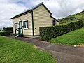
- Māngere Memorial Hall. A public hall opened in 1955, commemorating the soldiers who served in the First and Second World Wars.[23]: 13 [59]
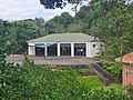
- Māngere Mountain Education Centre. Established in 1995 through the work of
- George Selwyn, the church was built from scoria rock collected from Māngere Mountain, much of the work done by the Ngāti Mahuta Māori Militia led by Tāmati Ngāpora.[24] The church was registered on 7 April 1983 by the New Zealand Historic Places Trust (now Heritage New Zealand) as a Category II historic place with registration number 689.[63]
- Ngāti Whāwhākia. It includes a meeting house, also called Te Puea.[64][65] The marae has helped hundreds of people find housing during the homelessness crisis, through a philosophy of manaakitanga.[66]
Natural areas
- Ambury Regional Park. Opened as a regional park on 26 September 1987, the area is an archaeological site and working farm,[8]: 62 which organises the annual Ambury Farm Day.[67] Areas of the park are leased to the Māngere Pony Club, and the Ambury Park Centre for Riding Therapy, a charity which provides physiological and psychological therapy through horse riding.[68] The Watercare Coastal Walkway, opened in 2005 after the removal of the oxidation ponds, links Ambury Regional Park to Ōtuataua Stonefields in the south.[69][70]
- pāhoehoe flows; hot fluid lava that travelled up to 10 km/h from the Māngere Mountain eruption, approximately 50,000 years ago.[71]
- Waiohua and Ngāti Whātua Ōrākei history. The mountain was set aside as a public domain in 1890, for use as a water reservoir, a quarry, and for recreation.[72]
- Māngere Lagoon. A volcanic maar and tidal lagoon, used as sewage oxidation ponds from 1959-2001,[73][74] after which it was ecologically restored and form a part of the Watercare Coastal Walkway.[75]
- Puketutu Island / Te Motu a Hiaroa. The first permanent home of the Tainui people in Aotearoa, after the Tainui waka was transported over the Te Tō Waka portage at Ōtāhuhu, from the Tāmaki River to the Manukau Harbour.[76] In the 1950s and 1960s, four scoria cones on the island were quarried for use in public works projects such as Auckland Airport and the Manukau Sewage Purification Works.[76] From 2014, the former site of the quarry has been the site of a Watercare Services project to recreate the quarried volcanic cones using biosolids from the Māngere Wastewater Treatment Plant.[76] After the project's completion, the island will become a regional park and cultural centre.[77][76]
Gallery
-
 Nesting area for birds at Ambury Regional Park
 -
 The Māngere Mountain Education Centre
 -
 Māngere Memorial Hall
 -
 St James Anglican Church and Māngere Mountain
 -
 Variable oystercatchers along the Kiwi Esplanade Walkway
 -
 Satellite view of Māngere Bridge
 -
 Restored cottage built for Tāwhiao, the second Māori King


Politics
| 2020 General election party vote | ||||||
|---|---|---|---|---|---|---|
| Party | Māngere[78] | Tāmaki Makaurau[79] | New Zealand[80] | |||
| Suburb | Electorate | Suburb | Electorate | |||
| ACT | 5.62% | 1.55% | 1.07% | 1.08% | 7.58% | |
| Green | 8.32% | 3.99% | 12.15% | 10.65% | 7.86% | |
| Labour | 56.91% | 77.37% | 63.11% | 61.09% | 50.01% | |
Māori |
0.92% | 0.90% | 10.23% | 12.93% | 1.17% | |
| National | 20.38% | 9.11% | 3.20% | 3.16% | 25.58% | |
| NZ First | 3.67% | 2.76% | 5.76% | 4.28% | 2.60% | |
Māngere Bridge is a part of the Māngere-Ōtāhuhu local government area in Auckland,[81] which elects seven board members to serve on the Māngere-Ōtāhuhu Local Board,[82] The board is currently chaired by Lemauga Lydia Sosene,[83] and all seven members are affiliated to the New Zealand Labour Party.[82] The Māngere-Ōtāhuhu local government area is within the Auckland council's Manukau ward,[84] and is currently represented on the Auckland Council by two councillors: Fa'anānā Alf Filipaina and Lotu Fuli.[85]
Māngere Bridge is located within the Māngere general and Tāmaki Makaurau Māori parliamentary electorates. Since the 2008 New Zealand general election, the Māngere electorate has been represented by Aupito William Sio,[86] while Peeni Henare has been the Member of Parliament for Tāmaki Makaurau since 2014.[87] In the 2014 New Zealand general election, the voters of the suburb narrowly preferred the New Zealand National Party,[88] despite the electorate overall voting strongly for the Labour Party.[89] Māngere Bridge voters gave a relative majority to the Labour Party in 2017.[88] Among Māngere Bridge polling stations in 2017 and 2020, support for the New Zealand National Party and Green Party of Aotearoa New Zealand was higher compared to the overall average for the Māngere electorate.[78][90]
Education

The Māngere Bridge area was originally served by the Māngere Central School, which opened in Māngere in 1859.[91] The first school in the suburb was Māngere Bridge School, which opened in 1890.[23]: 12 This was followed by Waterlea Public School (originally called Māngere Bridge No. 2 School) and Mountain View School (originally known as Miller Road Primary School) in 1955 and 1963, respectively.[92][93] These three schools are contributing primary schools (years 1–6) with rolls of 308, 409 and 229 students, respectively.[94][95][96]
Ambury Park Centre is a private secondary school (years 9–13) for students with disabilities. It has a roll of 8 students.[97] Horse riding and care of horses are an important feature of their educational programme.[98] Auckland Seventh-day Adventist High School is a state-integrated secondary school (years 9–13) with a roll of 315 students.[99]
All these schools are coeducational. Rolls are as of February 2024.[100]
Transportation
Māngere Bridge is accessible by the Southwestern Motorway, which first served the suburb after the opening of the motorway bridge in 1983.[39] The motorway was gradually extended northwest and southeast, and completed in July 2017.[43]
In October 2016, a new bus network was implemented for South Auckland by Auckland Transport, involving three bus routes that served Māngere Bridge: the 309 between Māngere Town Centre and the Auckland CBD; the 313 service connecting Onehunga town centre to Manukau via Māngere and Papatoetoe; and the 380 connecting to Auckland Airport.[101] In July 2021, the 36 and 38, frequent bus services to Manukau and Auckland Airport, replaced the 313 and 380.[102] Māngere Bridge is a planned stop for the City Centre-to-Māngere light rail project.[46]
Amenities

Māngere Bridge is home to
Notable people
- Alf Filipaina – former Māngere Bridge community constable,[106] and Manukau ward councillor from 2010[107]
- David Lange – former prime minister[108]
- Willie Jackson – politician, broadcaster[109]
- Mike King – comedian, mental health advocate[110]
- Mahuta Tāwhiao – third Māori king[19]: 3
- Tumate Mahuta – Ngāti Mahuta (Tainui) tribal leader[19]: 6
- Tonga Mahuta – Ngāti Mahuta tribal leader[19]: 6
- Peter Murdoch – All Black and former member of the Mangere Rugby Football Club[111]
- Waka Nathan – All Black and former member of the Mangere Rugby Football Club[111]
- Tāmati Ngāpora – St James Anglican Church preacher, adviser to the Māori King[112]
- Māori King[19]: 3
- William Sio – politician[113]
- Māori King[114]
- Jon Zealando – magician, who won the Grand Master of Magic Award with his wife Janet in 1985[115]
References
- ^ a b "ArcGIS Web Application". statsnz.maps.arcgis.com. Retrieved 17 November 2023.
- ^ a b "Population estimate tables - NZ.Stat". Statistics New Zealand. Retrieved 25 October 2023.
- ^ a b "Mangere – Property". The New Zealand Herald. 7 May 2005. Retrieved 7 February 2011.
- ^ a b "Place name detail: Māngere Bridge". New Zealand Gazetteer. New Zealand Geographic Board. Retrieved 2 August 2019.
- ^ Tūpuna Maunga o Tāmaki Makaurau Authority (23 June 2016). "Integrated Management Plan" (PDF). Auckland Council. Retrieved 6 October 2021.
- ^ a b c Trilford, Danielle (28 November 2017). "Archaeological investigations of site R11/2125, 63 Kiwi Esplanade, Mangere Bridge (HNZPTA authority 2018/046)" (PDF). CFG Heritage. Retrieved 21 October 2021.
- ^ "ca 1720". Manukau's Journey - Ngā Tapuwae o Manukau. Auckland Libraries Heritage Collections. MJ_0015. Retrieved 17 March 2021.
- ^ a b c d e f g "History of the Ambury Area - Auckland Regional Council Ambury Regional Park Management Plan 1994" (PDF). Auckland Council. 1994. Archived from the original (PDF) on 30 July 2012. Retrieved 6 July 2021.
- ^ Ballara 2003, pp. 206.
- Wikidata Q58677038.
- ^ a b Stone 2001, pp. 43.
- ^ Ngāti Whātua-o-Ōrākei. Retrieved 24 September 2021.
- ^ a b c d e f g Patterson, Malcolm (21 March 2008). "Ngati Whatua o Orakei Heritage Report for State Highway 20; Transit Manukau Harbour Crossing" (PDF). Environmental Protection Authority. pp. 6–7. Retrieved 21 October 2021.
- ^ Stone 2001, pp. 175.
- ^ "20 March 1840". Manukau's Journey - Ngā Tapuwae o Manukau. Auckland Libraries Heritage Collections. MJ_0075. Retrieved 21 October 2021.
- ^ Taonui, Rāwiri (8 February 2005). "Ngāti Whātua and the Treaty of Waitangi". Te Ara. Retrieved 24 October 2021.
- ^ Stone 2001, pp. 248.
- ^ "August 1840". Manukau's Journey - Ngā Tapuwae o Manukau. Auckland Libraries Heritage Collections. MJ_0087. Retrieved 22 October 2021.
- ^ a b c d e f g h i j k l m n o p q Campbell, Matthew; Harris, Jaden; Maguire, Wesley; Hawkins, Stuart (10 October 2013). "The Tawhiao Cottage" (PDF). CFG Heritage. Retrieved 21 October 2021.
- ^ Māngere-Ōtāhuhu Local Board (21 June 2017). "Māngere-Ōtāhuhu Local Board Open Agenda" (PDF). Auckland Council. Retrieved 7 October 2021.
- ^ a b c d Payne 2005, pp. 5–8.
- ^ "August 1857". Manukau's Journey - Ngā Tapuwae o Manukau. Auckland Libraries Heritage Collections. MJ_0347. Retrieved 24 October 2021.
- ^ a b c d e f g h i j k l m n o p q r s t u "Māngere Bridge, Māngere East and Favona Built Heritage Survey" (PDF). Auckland Council. June 2016. Retrieved 24 October 2021.
- ^ a b "1 January 1860". Manukau's Journey - Ngā Tapuwae o Manukau. Auckland Libraries Heritage Collections. MJ_0407. Retrieved 24 October 2021.
- ^ Lancaster & La Roche 2011, pp. 161–167.
- ^ "1 October 1886". Manukau's Journey - Ngā Tapuwae o Manukau. Auckland Libraries Heritage Collections. MJ_1237. Retrieved 25 October 2021.
- ^ a b Payne 2005, pp. 8–11.
- ^ "22 June 1887". Manukau's Journey - Ngā Tapuwae o Manukau. Auckland Libraries Heritage Collections. MJ_1180. Retrieved 25 October 2021.
- ^ "31 May 1915". Manukau's Journey - Ngā Tapuwae o Manukau. Auckland Libraries Heritage Collections. MJ_1765. Retrieved 25 October 2021.
- ^ a b "December 1925". Manukau's Journey - Ngā Tapuwae o Manukau. Auckland Libraries Heritage Collections. MJ_2231. Retrieved 25 October 2021.
- ^ "The Oriental Rendezvous". The New Zealand Herald. Vol. LXIII, no. 19230. 20 January 1926. p. 6. Retrieved 18 October 2021 – via Papers Past.
- ^ "Personal". Auckland Star. Vol. LXIII, no. 44. 22 February 1932. p. 1. Retrieved 18 October 2021 – via Papers Past.
- ^ Lee-Morgan, Jenny Bol Jun; Hoskins, Rau (2017). "Kainga tahi, kainga rua: A kaupapa Maori Response of Te Puea Memorial Marae". Parity.
- ^ a b c "24 September 1960". Manukau's Journey - Ngā Tapuwae o Manukau. Auckland Libraries Heritage Collections. MJ_3712. Retrieved 27 October 2021.
- ^ a b c d "The history of wastewater treatment in Auckland, 1878 to 2005". Watercare Services. Retrieved 27 October 2021.
- ^ "7 July 1954". Manukau's Journey - Ngā Tapuwae o Manukau. Auckland Libraries Heritage Collections. MJ_3319. Retrieved 27 October 2021.
- ^ "29 July 1983". Manukau's Journey - Ngā Tapuwae o Manukau. Auckland Libraries Heritage Collections. MJ_5476. Retrieved 27 October 2021.
- ^ "Highway 20 8-lane city motorway". Auckland Libraries. National Library of New Zealand. 3 February 1970. Retrieved 27 October 2021.
- ^ a b c "19 February 1983". Manukau's Journey - Ngā Tapuwae o Manukau. Auckland Libraries Heritage Collections. MJ_5453. Retrieved 27 October 2021.
- ^ Derby, Mark (11 March 2010). "Strikes and labour disputes - The decline of the arbitration system". Te Ara. Retrieved 27 October 2021.
- ^ ISBN 978-0-478-10554-4. Retrieved 27 October 2021.
- ^ "Mangere Bridge opened today". The New Zealand Herald. 25 July 2010. Retrieved 30 January 2011.
- ^ a b "Auckland's Waterview Tunnel open to traffic at last". Stuff.co.nz. 2 July 2017. Retrieved 2 July 2017.
- ^ Neale, Imogen (26 November 2018). "Floral farewell for historic Auckland bridge". Stuff. Retrieved 27 October 2021.
- ^ Forbes, Stephen (7 August 2022). "Waka Kotahi adds finishing touches to new $38m Māngere bridge". Radio New Zealand. Retrieved 8 August 2022.
- ^ a b "Onehunga - Conceptual Masterplan Study" (PDF). Environmental Protection Authority. 20 May 2017. Retrieved 27 October 2021.
- ^ "What you need to know about the $28b Auckland Transport Alignment Project". Stuff. 26 April 2018. Retrieved 27 October 2021.
- ^ "Auckland Light Rail" (PDF). Auckland Light Rail. July 2021. Retrieved 7 January 2022.
- ^ Williams, Amy (30 November 2023). "Auckland Light Rail: New government taking advice after stopping work on project". Radio New Zealand. Retrieved 1 December 2023.
- ^ a b "Statistical area 1 dataset for 2018 Census". Statistics New Zealand. March 2020. Māngere Bridge Ambury (146100), Māngere Bridge (146800) and Māngere Mountain View (147500).
- ^ 2018 Census place summary: Māngere Bridge Ambury
- ^ 2018 Census place summary: Māngere Bridge
- ^ 2018 Census place summary: Māngere Mountain View
- ^ Hawkes, Colleen (2 March 2020). "Suburb snapshot: Mangere Bridge is where the locals buy back in". Stuff. Retrieved 27 October 2021.
- ^ "Māngere-Ōtāhuhu Local Board Open Minutes". Māngere-Ōtāhuhu Local Board. 9 December 2020. Retrieved 27 October 2021.
- ^ "Mangere Bridge stalwart Naomi Kirk dies aged 83". Manukau Courier. Stuff. 12 February 2016. Retrieved 27 October 2021.
- ^ Fernandes, Kymberlee (26 July 2018). "Māngere Bridge community leader Bill Kirk dies at age 94". Manukau Courier. Stuff. Retrieved 27 October 2021.
- ^ "June 2004". Manukau's Journey - Ngā Tapuwae o Manukau. Auckland Libraries Heritage Collections. MJ_7037. Retrieved 27 October 2021.
- ^ Ringer, Bruce (2013). "Mangere memorial hall". NZHistory. New Zealand Government. Retrieved 27 October 2021.
- .
- ^ "Te Pane o Mataoho Mangere Mountain Education Trust Statement of intent 2018-21" (PDF). Auckland Council. 5 October 2018. Retrieved 24 October 2021.
- ^ Māngere-Ōtāhuhu Local Board (21 June 2017). "Māngere-Ōtāhuhu Local Board Open Agenda" (PDF). Auckland Council. Retrieved 7 October 2021.
- ^ "St James' Church (Anglican)". New Zealand Heritage List/Rārangi Kōrero. Heritage New Zealand. Retrieved 29 October 2021.
- ^ "Te Kāhui Māngai directory". tkm.govt.nz. Te Puni Kōkiri.
- ^ "Māori Maps". maorimaps.com. Te Potiki National Trust.
- ^ Nielson, Michael (19 September 2018). "Te Puea Marae model of manaakitanga 'key' to tackling homelessness crisis". New Zealand Media and Entertainment. The New Zealand Herald. Retrieved 9 January 2022.
- ^ "Ambury Farm Day to return in 2019". Auckland Council. Our Auckland. 3 October 2018.
- ^ Payne 2005, pp. 97–100, 110–113.
- ^ "Coastal Walkway". Watercare Services. Retrieved 27 October 2021.
- ^ "11 March 2005". Manukau's Journey - Ngā Tapuwae o Manukau. Auckland Libraries Heritage Collections. MJ_7048. Retrieved 27 October 2021.
- ^ Hayward 2019, pp. 426–436.
- ^ "1 August 1890". Manukau's Journey - Ngā Tapuwae o Manukau. Auckland Libraries Heritage Collections. MJ_1300. Retrieved 24 October 2021.
- ^ "August 1959". Manukau's Journey - Ngā Tapuwae o Manukau. Auckland Libraries Heritage Collections. MJ_3675. Retrieved 27 October 2021.
- ^ "17 May 2001". Manukau's Journey - Ngā Tapuwae o Manukau. Auckland Libraries Heritage Collections. MJ_6730. Retrieved 27 October 2021.
- ^ Clement, Diana (15 January 2011). "Under the volcanoes". The New Zealand Herald. Retrieved 27 October 2021.
- ^ a b c d Hutt, Kendall (5 May 2019). "Volcanic island's cones to be rebuilt with millions of tonnes of human waste". Stuff. Retrieved 27 October 2021.
- ^ "29 October 2010". Manukau's Journey - Ngā Tapuwae o Manukau. Auckland Libraries Heritage Collections. MJ_7514. Retrieved 27 October 2021.
- ^ a b "Māngere 21 party vote details". Electoral Commission. 2020. Retrieved 7 January 2022.
- ^ "Tāmaki Makaurau 68 party vote details". Electoral Commission. 2020. Retrieved 7 January 2022.
- ^ "2020 General election – official results and statistics". Electoral Commission. 30 November 2020. Retrieved 7 January 2022.
- ^ "Council profile". aucklandcouncil.govt.nz. Auckland Council.
- ^ a b "Local board members" (PDF). Auckland Council. 18 October 2019. Retrieved 27 October 2019.
- ^ Niall, Todd (3 April 2019). "Auckland mayor's salary to increase to nearly $300K as politicians see big pay rises". Retrieved 7 January 2022.
- ^ "Rohe o Manukau Manukau Ward". Auckland Council. Retrieved 7 January 2022.
- ^ "Local Elections 2022 - Official Results" (PDF). Auckland Council. 15 October 2022. Archived (PDF) from the original on 17 October 2022. Retrieved 17 October 2022.
- ^ "Māngere: Electoral Profile". New Zealand Parliament. 30 September 2012. Retrieved 7 January 2022.
- ^ "Tāmaki Makaurau – electorate profile". New Zealand Parliament. Retrieved 7 January 2022.
- ^ a b Williamson, Jarred (27 October 2017). "Battleground Booths: Māngere Bridge goes to Labour in 2017, National's vote still up". Retrieved 7 January 2022.
- ^ "Votes for Registered Parties by Electorate". Electoral Commission. Archived from the original on 24 August 2017. Retrieved 3 September 2017.
- ^ "Māngere 23 party vote details". Electoral Commission. 2017. Retrieved 7 January 2022.
- ^ "1 September 1859". Manukau's Journey - Ngā Tapuwae o Manukau. Auckland Libraries Heritage Collections. MJ_0384. Retrieved 27 October 2021.
- ^ "5 September 1955". Manukau's Journey - Ngā Tapuwae o Manukau. Auckland Libraries Heritage Collections. MJ_3391. Retrieved 27 October 2021.
- ^ "4 February 1963". Manukau's Journey - Ngā Tapuwae o Manukau. Auckland Libraries Heritage Collections. MJ_3926. Retrieved 27 October 2021.
- ^ Education Counts: Mangere Bridge School
- ^ Education Counts: Waterlea Public School
- ^ Education Counts: Mountain View School
- ^ Education Counts: Ambury Park Centre
- ^ "Secondary School". Ambury Park Centre. Archived from the original on 23 September 2020. Retrieved 18 August 2020.
- ^ Education Counts: Auckland Seventh-day Adventist High School
- ^ "New Zealand Schools Directory". New Zealand Ministry of Education. Retrieved 14 March 2024.
- ^ "New Network for South Auckland". Auckland Transport. 2016. Retrieved 7 January 2022.
- ^ "Changes to AirportLink, 38 and 349 bus services from Sunday 25 July". Auckland Transport. 2021. Archived from the original on 11 July 2021. Retrieved 7 January 2022.
- ^ "May 1965". Manukau's Journey - Ngā Tapuwae o Manukau. Auckland Libraries Heritage Collections. MJ_4107. Retrieved 7 January 2022.
- ^ "We'll be back, say overjoyed Scouts". Stuff.co.nz. 16 February 2009. Retrieved 7 January 2022.
- ^ "October 1978". Manukau's Journey - Ngā Tapuwae o Manukau. Auckland Libraries Heritage Collections. MJ_5144. Retrieved 7 January 2022.
- ^ Payne 2005, pp. 105–110.
- ^ "Confirmed Local Election Results 2016" (PDF). Archived from the original (PDF) on 19 October 2016. Retrieved 19 October 2016.
- ^ "8 December 1990". Manukau's Journey - Ngā Tapuwae o Manukau. Auckland Libraries Heritage Collections. MJ_5984. Retrieved 26 October 2021.
- ^ Trevett, Claire (11 February 2017). "Jackson's new Labour of love". The New Zealand Herald. Retrieved 26 October 2021.
- ^ Loren, Anna (24 October 2013). "A cool King". Stuff. Retrieved 26 October 2021.
- ^ a b Payne 2005, pp. 47–48.
- ^ "1 January 1860". Manukau's Journey - Ngā Tapuwae o Manukau. Auckland Libraries Heritage Collections. MJ_0407. Retrieved 26 October 2021.
- ^ Kronast, Hannah (7 August 2020). "The number of properties owned by New Zealand MPs revealed". Newshub. Retrieved 27 October 2021.
- ^ Māngere-Ōtāhuhu Local Board (21 June 2017). "Māngere-Ōtāhuhu Local Board Open Agenda" (PDF). Auckland Council. Retrieved 7 October 2021.
- ^ Payne 2005, pp. 62–63.
Bibliography
- ISBN 9780143018896.
- ISBN 978-0-582-71784-8.
- Lancaster, Mike; ISBN 9781927167038.
- Payne, Val (2005). Celebrating Mangere Bridge. Mangere Historical Society. ISBN 0-476-00941-3.
- ISBN 1869402596.
External links
- It's All About Māngere Bridge community website and newsletter
- Photographs of Māngere Bridge held in Auckland Libraries' heritage collections.
- Photographs of Māngere Bridge held in Auckland Museum's heritage collections.
- Photographs of Māngere Bridge held in the National Library of New Zealand's heritage collections.