
MacArthur Causeway
MacArthur Causeway County Causeway | ||
|---|---|---|
Clearance above 68 feet (21 m) | | |
| History | ||
| Designer | Frederic R. Harris, Inc., American Bridge Company | |
| Opened | February 17, 1920[1] | |
| Location | ||
 | ||
The General Douglas MacArthur Causeway is a six-lane causeway that connects Downtown Miami to South Beach via Biscayne Bay in Miami-Dade County.
The highway is the singular roadway connecting the mainland and beaches to Watson Island and the bay neighborhoods of Palm Island, Hibiscus Island, and Star Island. The MacArthur Causeway carries State Road 836 and State Road A1A over the Biscayne Bay via a girder bridge. Interstate 395 ends at Fountain Street, the entrance to Palm Island Park which has a traffic light as well as bus stops.
History
In the late 1910s, with the deteriorating wooden
reclaimed
surrounding the western end of the roadway, completed in 1926.
Having undergone several lane and structural expansions following opening of the original two-lane road, the
I-395
was complete in the 1970s. The replacement of the westernmost and easternmost spans began in the 1990s, as the eastbound lanes of the bridges were completed in 1995 and westbound lanes finished in 1997.
Gallery
-
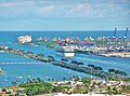 Large portion of the causeway.Watson Islandis in the foreground.
 -
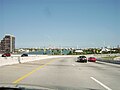 MacArthur Causeway eastbound from Miami to Miami Beach (in far background).
 -
 Macarthur Causeway at night as seen from Watson Island


Wikimedia Commons has media related to MacArthur Causeway.
Wikinews has related news:
References
- ISBN 0-7385-2351-8.
- ^ "Causeway Our Thanks for Bataan". The Miami News. April 6, 1964. p. 1A. Retrieved October 20, 2010.
External links
- MacArthur Causeway at Structurae, 2006