
MacDonnell Ranges
| MacDonnell Ranges | |
|---|---|
 Glen Helen Gorge in the MacDonnell Ranges | |
| Highest point | |
| Peak | Mount Zeil |
| Elevation | 1,531 m (5,023 ft) AHD |
| Coordinates | 23°22′59″S 132°22′59″E / 23.38306°S 132.38306°E |
| Dimensions | |
| Length | 644 km (400 mi) E/W |
| Naming | |
| Etymology | Sir Richard MacDonnell |
| Native name | Tjoritja (Arrernte language) |
| Geography | |
 Location of the MacDonnell Ranges in the Northern Territory | |
| Country | Australia |
Alice Springs | |
| Range coordinates | 23°42′S 132°30′E / 23.700°S 132.500°E |
| Geology | |
| Age of rock | Carboniferous |
| MacDonnell Ranges Northern Territory | |||||||||||||||
|---|---|---|---|---|---|---|---|---|---|---|---|---|---|---|---|
 The interim Australian bioregions, with the MacDonnell Ranges in red | |||||||||||||||
| Area | 39,294 km2 (15,171.5 sq mi) | ||||||||||||||
| |||||||||||||||
The MacDonnell Ranges, or Tjoritja in
The ranges were named after Sir
The MacDonnell Ranges were often depicted in the paintings of Albert Namatjira.[3]
Geography
The highest peaks are
Geology
Some 300-350 million years ago a mountain building event created the MacDonnell Ranges.
Ecology
Part of the
Tourist attractions
The
To the east of Alice Springs, within an hour's drive, are sites important to the local Arrernte people, many of which contain examples of Aboriginal rock art. These include Emily Gap, Jessie Gap, Trephina Gorge and N’Dhala Gorge.
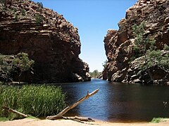
To the west of Alice Springs is the Larapinta Trail—a world-class, long distance bush walking trail that runs 223 kilometres (139 mi) along the backbone of the range.[5] Along the trail are Simpsons Gap, Standley Chasm, Ellery Creek Big Hole, Serpentine Gorge, Ochre Pits, Ormiston Pound, Redbank Gorge, Glen Helen Gorge, Mount Sonder and Mount Giles.
Gallery
-
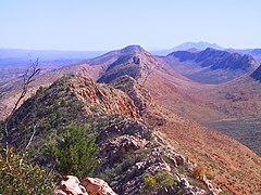 From the Larapinta Trail near Glen Helen
 -
 Ellery Creek Big Hole
 -
 Ellery Creek and river red gum trees
 -
 Ochre pits
 -
 Simpsons Gap
 -
 Serpentine Gorge


See also
- Geography of Australia
- List of mountains in Australia
- Pine Gap
- Western Arrernte
- N'Dhala Gorge Nature Park
- Heavitree Gap
References
- Australian Government. Archived from the originalon 5 September 2006. Retrieved 31 January 2007.
- ^ IBRA Version 6.1 Archived 2006-09-08 at the Wayback Machine data
- Fairfax Digital. Retrieved 17 November 2009.
- ^ a b c "Rangelands - Overview - MacDonnell Ranges". Australian Natural Resources Atlas. Department of the Environment, Water, Heritage and the Arts. Archived from the original on 5 October 2009. Retrieved 17 November 2009.
- ^ ISBN 1-875992-47-2.
- ^ World Wildlife Fund, ed. (2001). "Central Ranges xeric scrub". WildWorld Ecoregion Profile. National Geographic Society. Archived from the original on 8 March 2010.