
Madison station (CTA)
MADISON 1700W 1S | |||||||||||
|---|---|---|---|---|---|---|---|---|---|---|---|
| Former Chicago 'L' rapid transit station | |||||||||||
 The Madison station house in its final days, housing a hot dog stand in the 1990s; the steel structure behind the station house was used to support the stairways' landings | |||||||||||
| General information | |||||||||||
| Location | 1718 West Madison Street Chicago, Illinois, United States[1] | ||||||||||
| Coordinates | 41°52′53″N 87°40′12″W / 41.881491°N 87.670108°W | ||||||||||
| Owned by | Chicago Transit Authority | ||||||||||
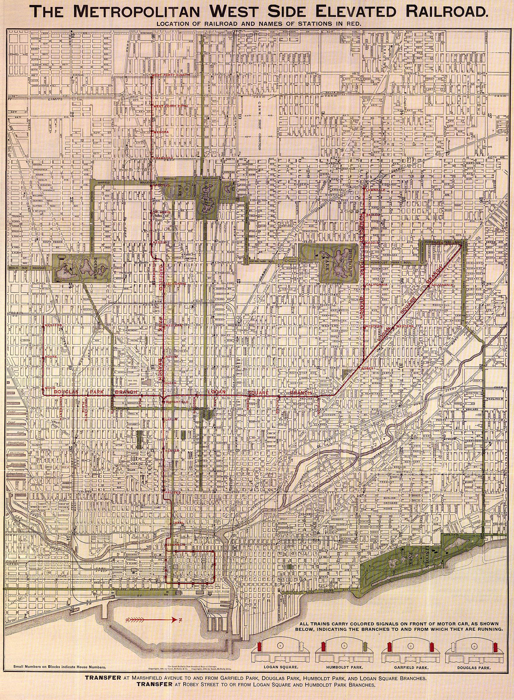
| Line(s) | Logan Square branch | ||||||||||
| Platforms | 2 side platforms | ||||||||||
| Tracks | 2 | ||||||||||
| Construction | |||||||||||
| Structure type | Elevated | ||||||||||
| History | |||||||||||
| Opened | May 6, 1895 | ||||||||||
| Closed | February 25, 1951 | ||||||||||
| Passengers | |||||||||||
| 1948 | 217,551 | ||||||||||
| Rank | 165 out of 223 | ||||||||||
| Former services | |||||||||||
| |||||||||||
| Location | |||||||||||
 | |||||||||||
Madison was a rapid transit station on the Chicago "L"'s Metropolitan West Side Elevated Railroad, serving its Logan Square branch from 1895 to 1951. The station was typical of those constructed by the Metropolitan, with a Queen Anne station house and two wooden side platforms adjacent to the tracks. For much of its existence, Madison served the nearby sports arena Chicago Stadium.
The Metropolitan was one of four founding companies of the "L", and the first of its lines to be
Plans to replace the Logan Square branch whereupon Madison lay with a subway to provide a more direct connection to
Given the proximity of the site to Chicago Stadium and its successor the United Center, there have been several attempts at reviving the station, especially after the opening of the Pink Line. In 2017, however, the CTA decided instead to reopen a station on Damen for the Green Line for added service to the United Center.
History
The
The Metropolitan's lines were originally operated by the West Side Construction Company, which had been responsible for constructing them, and were transferred to the Metropolitan on October 6, 1896.
Closure and demolition
Plans for Chicago to have a subway system to relieve the severe congestion of, if not replace, its elevated trackage dated back to the early 20th century, but the city lagged in building subways.[19] Chicago petitioned the Public Works Administration (PWA) for construction funds for a subway on State Street in 1937.[20] The petition originally included a proposal for two downtown east-west streetcar tunnels.[21] Harold L. Ickes, the administrator of the PWA and a longtime Chicagoan, vetoed the streetcar tunnel plan and insisted instead on a second subway that would go under Dearborn Street and Milwaukee Avenue, which would bypass the southern part of the branch and provide a more direct route from Logan Square to downtown.[21] Although this idea engendered considerable local opposition, especially from mayor Edward Joseph Kelly, Ickes's influence in the federal government led to the Dearborn plan being adopted in 1938.[21] A 1939 plan also introduced the idea of replacing the Metropolitan's main line and Garfield Park branch with a section of rapid transit operating through a proposed Congress superhighway (the eventual Interstate 290).[22] These sections of transit would be connected, allowing for the area's rapid transit to be routed through downtown rather than adhere to a trunk-and-branch model.[23]
The subway's approval did not immediately imply the end of the old Logan Square branch; plans in 1939 included another proposed subway to connect the branch with the Ravenswood branch to the north and through-routing it with the Douglas Park branch to the south into a subway on Ashland Avenue to form a crosstown route.[24] Damen Tower serving the Humboldt Park branch divergence was rebuilt with the expectation that it also would switch trains between the subway and the elevated, much like the State Street subway connects with the earlier elevated North Side main line that remained standing after its construction,[25] and as late as 1949 commuters were promised such a setup that would have preserved the old Logan Square trackage.[26] However, the CTA had no interest in operating either the old Logan Square elevated or the Humboldt Park branch; the new Damen Tower would never be installed with switching equipment, and the Logan Square branch south of Damen would be closed after the Dearborn subway opened.[25]
World War II interrupted the construction of the Dearborn Street subway; although the federal government allowed the continued construction of the State Street subway, it did not do so for the Dearborn Street subway even though it was 82 percent completed by 1942.[27] After the war ended, work resumed on the Dearborn Street subway and it opened at the midnight beginning Sunday, February 25, 1951; it was predicted to reduce the travel time between Logan Square and downtown from 28 minutes to 15.[27] Since construction had not started on the Congress Line, trains in the Dearborn subway stopped at its southern terminus at LaSalle and turned back.[27] Despite its incomplete state, and complaints from riders no longer given a direct trip to the Near West Side,[28][29] the new subway had over 60 percent higher ridership than the old Logan Square branch by the end of the year.[30]
The infrastructure of the former parts of the Logan Square branch remained standing and became known as the
The canopies and platforms at Madison were removed after its closure, but its station house was converted to commercial use, seeing use as a hot dog stand in the 1990s. The station house survived for much of the 20th century; the city of Chicago conducted the Chicago Historic Resources Survey between 1983 and 1995, marking tens of thousands of structures across Chicago for potential landmark status and color-coding them based on significance. The Madison station house received a code of "Orange", the second-highest color code and indicating a structure significant in the context of its community. Despite this status, the station house was demolished in the 1990s, although the truncated ends of the trusses that had supported the station's platforms and a steel lattice that had been located behind the station house remained until the area was renovated to reenter revenue service as the Pink Line in 2006.[33]
Possible revivals

During Madison's lifetime, it served the nearby Chicago Stadium, a sports arena that was replaced by the United Center in the 1990s.[35] Given the site's proximity to the United Center, there have been several proposals to revive the station. One such proposal was to reopen the station for the 1996 Democratic National Convention hosted at the United Center, but this did not come to pass.[33] In 2004, while the CTA was planning a putative "Silver Line" service on the Connector that would become the Pink Line, two new stations were proposed on the Line at Madison and at Van Buren for transfer to the Blue Line.[36] The Chicago Bulls, housed in the United Center, planned in 2012 to build a $95 million complex in the area based on possible tax breaks. Mayor Rahm Emanuel suggested building a station at Madison to serve the complex; the CTA declined to reopen a station at Madison at that time, but left open the possibility of a future revival.[33]
The Illinois Medical District station has an entrance on Damen Avenue that is used by attendees of events at the United Center, who are also able to use the Ashland station on the Green and Pink Lines as well as local buses. On February 9, 2017, the CTA announced plans for a new Green Line station on Damen Avenue to accommodate the United Center.[37] This new Damen station, a block and a half from the United Center, is much closer than the 0.75 miles (1.21 km) of the Medical District station, and replaces an earlier station on the site that had been closed in 1948.[38] Despite being located farther away from the United Center than Madison, the Damen site was chosen due to its location near industrial and residential areas and to close a 1.5 miles (2.4 km) gap on the Green Line between Ashland and California.
Station details

The station was designed by the Metropolitan's engineers and constructed by the Jonathan Clark and Sons Company for general contractor Alfred Walcott. The station house was made of red pressed brick with stone sills and foundations; much like the other stations on the Logan Square branch, surviving examples of which are at California station and Damen, it has been described as "Queen-Anne influenced with Romanesque features".[33] Its facade was dominated by a corniced and dentiled semicircular bay with two doors marked "entrance" and "exit" despite the lack of an enforcement mechanism for either, as well as a wooden awning for the bay underlaid by wooden beads.[33]
The station had two side platforms. In common with stations throughout the Metropolitan's system, the platforms and stairs were wooden on a steel structure, and had canopies with iron frames and tin
Operations and connections
As originally opened, the Metropolitan's trains ran every six minutes between 6 a.m. and 6:30 p.m., and every ten minutes during the night; the average speed was 16 mph (26 km/h).
The fare across the "L" was legally mandated to be a nickel (5 cents, $1.37 in 2021) in the late 19th and early 20th centuries. The nickel fare continued until temporarily increased by a cent to 6 cents in 1917 ($1.27 in 2021) before stabilizing to a dime in 1920 (10 cents, $1.35 in 2021).[40] Starting in 1922, fares were usually marketed in packs of three rides for 25 cents, or 8+1⁄3 cents per ride ($1.35 per ride in 2021), but individual fares remained 10 cents each.[41] At the same time, a weekly pass was introduced, the first in a major American city, for $1.25 ($20.24 in 2021) for rides entirely within city limits.[41] Unlike other elevated railroads at the time, the Metropolitan did not sell tickets for passengers to present to staff; instead customers gave their nickel to the station agent to record in a registry, a practice similar to streetcars at the time. This practice was ultimately adopted by the other elevateds.[12] Station agents on the Metropolitan were originally on duty 24 hours a day; fare collection by on-train conductors was adopted on the Northwest[a] between 1931 and 1934 and again during 1936 and 1937.[42]
Madison Street was one of the "Big Five" streetcar lines of Chicago in the early-to-mid 20th century, which carried the most passengers, had the shortest intervals between cars, and had two-
Ridership
In the last year ridership records are available, 1948, Madison served 217,551 passengers, a 21.12 percent decrease from the 275,802 in 1947.[47] In 1948, it was the 165th-most ridden of the 223 stations on the Chicago "L" at the beginning of the year where ridership was recorded; in 1947, it had been the 148th-most ridden of 222 such stations.[b][50]
Notes
- ^ a b c d Technically, the Logan Square branch started after Robey and was, like the Humboldt Park branch, a divergence from what was formally known as the "Northwest branch".[5] However, as early as 1898, even the Metropolitan itself was referring to the Northwest branch as part of the "Logan Square branch",[6] although ridership statistics continued to separate them.[7]
- ^ Several stations on the Niles Center and Westchester branches were permanently unmanned and thus did not collect ridership statistics.[48] Several stations closed on the "L" during 1948.[49] Exchange station on the Stock Yards branch lacked statistics for 1947 but returned in 1948.[47]
References
- ^ Polk Directory, p. 538
- ^ Moffat 1995, p. 123
- ^ 1895 Review, p. 263
- ^ a b c 1895 Review, p. 264
- ^ a b c Moffat 1995, p. 130
- ^ a b The Metropolitan West Side Elevated Railroad (Map). Metropolitan West Side Elevated Railroad. 1898. pp. 1–2 – via Chicago-L.org.
- ^ CTA 1979, pp. 10–14
- ^ 1895 Review, p. 267
- ^ Moffat 1995, p. 124
- ^ Borzo 2007, p. 43
- ^ a b c d "New "L" Road Opens". Chicago Tribune. Vol. 54, no. 127. May 7, 1895. p. 12 – via Newspapers.com.
- ^ a b c Moffat 1995, p. 134
- ^ Moffat 1995, p. 139
- ^ Moffat 1995, p. 237
- ^ Moffat 1995, pp. 240–242
- ^ Moffat 1995, p. 261
- ^ Moffat 1995, p. 260
- ^ Weller & Stark 1999, p. 131
- ^ Borzo 2007, p. 91
- ^ Borzo 2007, p. 92
- ^ a b c "Entries in Loop at Every Block; Begin Work Dec. 15". Chicago Tribune. Vol. 97, no. 245. October 13, 1938. pp. 1–2. Retrieved November 17, 2022 – via Newspapers.com.
- ^ CTA 1967, p. 9
- ^ CTA 1967, p. 5
- ^ CTA 1939, p. 16
- ^ a b Garfield, Graham. "Damen Tower". Chicago-L.org. Retrieved November 18, 2022.
- ^ "Work Speeds on Building New Subway". Chicago Tribune. Vol. 108, no. 34. August 21, 1949. p. 3–1. Retrieved November 20, 2022 – via Newspapers.com.
- ^ a b c Buck, Thomas (February 18, 1951). "1st Trains Run in New Subway Saturday Night". Chicago Tribune. Vol. 110, no. 7, Part 1. p. 21. Retrieved October 16, 2022 – via Newspapers.com.
- ^ Nedella, Carola (March 5, 1951). "Results of Eliminating the Logan Square "L"". Chicago Tribune. Vol. 110, no. 62. p. 1–20. Retrieved November 22, 2022 – via Newspapers.com.
- ^ Serpico, Lillian (May 15, 1951). "Inconvenienced Riders". Chicago Tribune. Vol. 110, no. 116. p. 1–14. Retrieved November 19, 2022 – via Newspapers.com.
- ^ CTA 1951, p. 1
- ^ a b Garfield, Graham. "Paulina Connector". Chicago-L.org. Archived from the original on January 19, 2022. Retrieved October 10, 2022.
- ^ a b CTA 1954, p. 12
- ^ a b c d e f g Garfield, Graham. "Madison". Chicago-L.org. Retrieved October 9, 2022.
- ^ Weller & Stark 1999, p. 149
- ^ Weller & Stark 1999, p. 37
- ^ Hilkevitch, Jon (July 19, 2004). "Blue-Green Line link considered". Chicago Tribune. Vol. 158, no. 201. p. 2-1. Retrieved October 16, 2022 – via Newspapers.com.
- ^ Wisniewski, Mary (February 9, 2017). "City plans new CTA Green Line station at Damen, near United Center". Chicago Tribune. Retrieved February 3, 2023.
- ^ Lulay, Stephanie (February 9, 2017). "New $50 Million Green Line Station Planned Near United Center". DNAInfo.com. Archived from the original on February 10, 2017. Retrieved February 3, 2023.
- ^ Moffat 1995, p. 115
- ^ Moffat 1995, pp. 254–255
- ^ a b Moffat 1995, p. 255
- ^ CTA 1979, p. 13
- ^ a b c Lind 1974, p. 201
- ^ a b c Lind 1974, p. 280
- ^ Lind 1974, p. 203
- ^ Lind 1974, p. 284
- ^ a b CTA 1979, p. 14
- ^ CTA 1979, pp. 22 & 38
- ^ Chicago Transit Authority (April 5, 1948). "New Lake Street All-Express "L" Service". Chicago Tribune. Vol. 107, no. 82. p. 7. Archived from the original on February 13, 2022. Retrieved February 13, 2022 – via Newspapers.com.
- ^ CTA 1979, pp. 6, 14, 22, 30, & 38
Works cited
- "The Metropolitan West Side Elevated Railroad of Chicago". The Street Railway Review. 5: 263–274. January 15, 1895.
- Borzo, Greg (2007). The Chicago "L". Charleston, South Carolina: Arcadia. ISBN 9780738551005– via Google Books.
- Department of Subways and Traction (1939). A Comprehensive Plan for the Extension of the Subway System of the City of Chicago. Chicago: City of Chicago – via Internet Archive.
- Chicago Transit Authority (1951). Seventh Annual Report of Chicago Transit Board for the Fiscal Year ended December 31, 1951 – via Archive.org.
- Chicago Transit Board (1954). Tenth Annual Report for the Fiscal Year ended December 31, 1954 – via Archive.org.
- Chicago Transit Authority (1967). Congress Rapid Transit (Report).
- CTA Rail Entrance, Annual Traffic, 1900–1979 (Report). Chicago: Chicago Transit Authority. October 1, 1979.
- Lind, Alan R. (1974). Chicago Surface Lines: An Illustrated History. Park Forest, Illinois: Transport History Press.
- Moffat, Bruce G. (1995). The "L": The Development of Chicago's Rapid Transit System, 1888–1932. Chicago: Central Electric Railfans' Association. ISBN 0-915348-30-6.
- Polk's Chicago (Illinois) Numerical Street and Avenue Directory (PDF). Chicago: R. L. Polk and Company. 1928. Archived from the original (PDF) on August 27, 2016. Retrieved January 10, 2023 – via Chicago Historical Society.
- Weller, Peter; Stark, Fred (1999). The Living Legacy of the Chicago Aurora and Elgin. San Francisco: Forum Press. ISBN 0-945213-41-7– via Internet Archive.