
Madrid metropolitan area
This article possibly contains original research. (August 2022) |
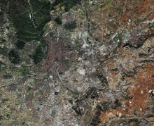
The Madrid metropolitan area is a monocentric metropolitan area in the centre of the Iberian peninsula, around the
municipality of Madrid
, Spain. It is not related to any sort of administrative delimitation, and thus, its limits are ambiguous.
According to data from the
Two distinct zones of urbanisation can be distinguished extending further than the municipality of Madrid:
- Inner ring (primera corona): Alcorcón, Leganés, Getafe, Móstoles, Fuenlabrada, Coslada, Alcobendas, Pozuelo de Alarcón, San Fernando de Henares
- Outer ring (segunda corona): Villaviciosa de Odón, Parla, Pinto, Valdemoro, Rivas-Vaciamadrid, Torrejón de Ardoz, Alcalá de Henares, San Sebastián de los Reyes, Tres Cantos, Las Rozas de Madrid, Majadahonda, Boadilla del Monte, Collado Villalba.
The largest suburbs are to the south, and in general along the main routes leading out of Madrid.
The GDP of the metropolitan area of Madrid was estimated to be 189 billion euros in 2009 and represents over 90% of the GDP of the region of Madrid.[6] The GDP per capita was 37,758 euros in the metropolitan area while it reached 30,453 euros for the Madrid region, the Community of Madrid.
In regard to the Madrid
environmental sustainability of the current mobility model.[7]
References
- (in Spanish) AUDES5 project.
- ^ OECD-OCDE – Spain
- ^ "World Urban Areas: Population & Density" (PDF). Demographia. Retrieved 2008-08-10.
- ^ Eurostat, Urban Audit database Archived 2011-04-06 at the Wayback Machine, accessed on 2009-03-12. Data for 2004.
- ^ Thomas Brinkoff, Principal Agglomerations of the World, accessed on 2009-03-12. Data for 2009-01-01.
- ^ United Nations Department of Economic and Social Affairs, World Urbanisation Prospects (2007 revision), (United Nations, 2008), Table A.12. Data for 2007.
- ^ (in Spanish)http://www.madrid.org/iestadis/fijas/estructu/economicas/contabilidad/descarga/ipibmt1.xls
- ^ ISBN 978-84-17358-85-3.
| Authority control databases: National |
|---|