
Magaliesberg
| Magaliesberg | |
|---|---|
| Macalisberg, Cashan Mountains, Dithaba Diloka. | |
Hartebeespoort Dam from vicinity of Castle Gorge  Magaliesberg mountain range, seen from space with the Operational Land Imager on Landsat 8, 27 June 2018 | |
| Highest point | |
| Elevation | Nooitgedacht |
| Coordinates | 25°51′30″S 27°31′48″E / 25.8583°S 27.530°E[1] |
| Dimensions | |
| Area | 357,870 hectares (884,300 acres) |
| Naming | |
| Etymology | Mogale's mountain |
| Geography | |
| Range coordinates | 25°30′01″S 27°21′37″E / 25.5002°S 27.3603°E |
| Biome | Bushveld and Highveld |
| Geology | |
| Age of rock | 2 billion years (Orosirian Period) |
| Mountain type | Mountain range |


The Magaliesberg (historically also known as Macalisberg or Cashan Mountains[2]) of northern South Africa, is a modest but well-defined mountain range composed mainly of quartzites. It rises at a point south of the Pilanesberg (and the Pilanesberg National Park) to form a curved prominence that intersects suburban Pretoria before it peters out some 50 km (31 mi) to the east, just south of Bronkhorstspruit. The highest point of the Magaliesberg is reached at Nooitgedacht, about 1,852 metres (6,076 ft) above sea level. A cableway reaching to the top of the mountain range is located at Hartbeespoort Dam, providing sweeping views of the Magaliesberg and surrounding area.[3]
Geology
The Magaliesberg has ancient origins. Its composition is ascribed to successive
Climate

The range forms a natural barrier between the lower lying Bushveld to the north and the cooler Highveld to the south. The range receives rainfall in summer in the form of thunderstorms, with an average of 650 mm (26 in) annually. In winter, frost occurs frequently in the valleys on the southern side of the mountain, but almost never on the northern slopes.[citation needed]
History


The area around the Magaliesberg range has seen extremely lengthy occupation by humans dating back at least 2 million years to the earliest
The earliest known name for the Magaliesberg mountains is Dithaba Diloka. This is a local seTswana name in reference to the abundance of Heteropogon contortus which grows in the area. However it seems this name would have only been used by neighbouring Sotho-Tswana_peoples coming to and from the Magaliesberg mountains. Local resident Tswana tribes referred to it simply as Dithaba "The mountains".[4]
The first European explorers who came to the area recorded the mountains being called the "Cashan" or "Kashan" mountains. This was a corruption of the name of a powerful chief of the BaKwena ba Mmatau whose name was Kgwasane wa Sekano (Kgwasane, son of Sekano).[5]
In the mid-1800s the mountain range became known as Magaliesberg (lit. Mogale's mountain) after Kgosi Mogale.[6] Mogale means "sharp" or "brave" person, but is also the common word for a warrior or Tswana soldier, in Sotho bogale means "sharp" and mogale is "brave". Similarly, the mountain range to the north, near Sun City, Pilanesberg, was named after the local Bakgatla chiefs, who were called Pilane. [citation needed]
In 1822, Shaka, the leader of the Zulu Kingdom, sent his most trusted commander, Mzilikazi, to conquer the Sotho tribes of the region. After accomplishing this task, Mzilikazi decided to break away from Shaka and found his own nation, the Matabele. As he feared an attack from Shaka if he returned home, he settled in the Magaliesberg region.
On 17 January 1837, after some
The area saw some heavy fighting during the Second
Control of the Magaliesberg Mountain Range was of great importance to both the Boer and the British forces, especially the two routes between Pretoria and Rustenburg, which crossed it at Silkaatsnek and Kommandonek, respectively. As a result, many battles, such as the battles of Buffelspoort, Nooitgedacht and Olifantsnek were fought in the area.
After the war, farms in the area were reoccupied and farming was resumed, tobacco and citrus being particularly successful.
In 1923 the
At present, the Magaliesberg area is still largely agricultural, although tourism is a rapidly growing industry in the area.
Kgaswane Mountain Reserve is a nature reserve above Rustenburg covering 4,257 ha (10,520 acres) of the Magaliesberg.
Numerous smaller reserves, private and state, are to be found along the length of the range.
Magaliesberg Biosphere Reserve


After nearly a decade of lobbying and sustained efforts by a small committee of dedicated environmentalists, the Magaliesberg has been declared a World Biosphere Reserve.
The announcement was made on 9 June 2015 in Paris by the International Coordinating Council of the Programme on Man and the Biosphere (MAB). This is a UNESCO programme that aims to build a supportive and sustainable relationship between people and their environments. In effect, this means a specific focus on safeguarding natural ecosystems through innovative approaches to economic development.
The World Network of Biosphere Reserves, which Magaliesberg now joins, counts 631 biosphere reserves in 119 countries.
"We are delighted with this final acknowledgement of the unique nature of the Magaliesberg and the powerful contribution it is making to our country, to the ecosystem services in Gauteng and the North West and the communities it nurtures over an extensive area," said Paul Fatti, chair of the Magaliesberg Biosphere Initiative Group (MBIG) that has been lobbying authorities since 2007 to support the establishment of the biosphere.[citation needed]
Vincent Carruthers, past chair of MBIG and renowned author of The Magaliesberg, the most authoritative study of the mountain range, said that this announcement was the culmination of a campaign that began in 2006. "I'm most grateful there is now international recognition of this great mountain range that has witnessed the whole span of life, from its very origins," he said. "The Magaliesberg is almost 100 times older than Mount Everest and half the
Rock climbing
The Magaliesberg mountains offer excellent rock climbing opportunities, spread across its many kloofs and escarpments. The climbing is mostly traditional, with a small number of sport climbing venues and hundreds of routes across a wide range of grades. The relatively mild climate allows year-round climbing.
Gallery
-
 Southern cliffs of Magaliesberg, near Skeerpoort
 -
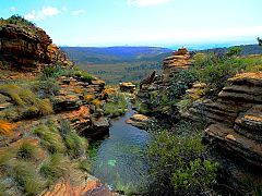 Stream
 -
 Rock formation


References
- ^ "Magaliesberg | United Nations Educational, Scientific and Cultural Organization". UNESCO. Retrieved 15 September 2018.
- ^ Stow, George William (1905). The native races of South Africa; a history of the intrusion of the Hottentots and Bantu into the hunting grounds of the Bushmen, the aborigines of the country. The Macmillan Co. p. 546.
- ^ Harties Aerial Cableway
- ^ "Magaliesburg & Magaliesberg: the origin of its peoples; the naming of the region". capeinfo.com. Retrieved 21 November 2022.
- ^ "Kgosi Kgaswane and the Bakwena ba Modimosana ba Mmatau of the Tswana People | The Heritage Portal". www.theheritageportal.co.za. Retrieved 21 November 2022.
- ^ Jenkins, Elwyn (2007), Falling into place: the story of modern South African place names, David Philip Publishers, p. 75
External links
- Magaliesberg Protection Association
- Kgaswane Mountain Reserve
- Mining Threat to UNESCO Magaliesberg Biosphere
| Authority control databases: National |
|---|