
Magdalena Department
This article needs additional citations for verification. (February 2013) |
You can help expand this article with text translated from the corresponding article in Spanish. (September 2012) Click [show] for important translation instructions.
|
Department of Magdalena
Departamento del Magdalena | |
|---|---|
|
UTC-05 | |
| ISO 3166 code | CO-MAG |
| Municipalities | 31 |
| HDI (2019) | 0.726[5] high · 22nd of 33 |
| Website | www.gobmagdalena.gov.co |
Magdalena (Spanish pronunciation: [maɣðaˈlena]) is a department of Colombia with more than 1.3 million people, located to the north of the country by the Caribbean Sea. The capital of the Magdalena Department is Santa Marta and was named after the Magdalena River. It inherited the name of one of the original nine states of the United States of Colombia that its current territory integrated.
Geography

| Year | Pop. | ±% |
|---|---|---|
| 1973 | 540,258 | — |
| 1985 | 890,934 | +64.9% |
| 1993 | 1,127,631 | +26.6% |
| 2005 | 1,149,917 | +2.0% |
| 2018 | 1,341,746 | +16.7% |
| Source:[6] | ||
Location
The Department of Magdalena is located on the North Coast of the Colombian
On the north it borders the Caribbean Sea. On the northeast it borders the La Guajira Department, being divided by the Palomino River. On the east it borders with the Cesar Department, which is in part divided by the Guaraní River.
On the west, it is divided by the Magdalena River, and it borders the departments of Atlantico in the Northwest, and Bolívar in the West and Southwest.
Hydrology
Basins
The territory of the Department of Magdalena is formed by four drainage basins which are very different in composition and importance.
- Sierra Nevada's Northern Slope
The drainage basin of the Sierra Nevada's western slope is located in the northern part of the department. The Sierra Nevada de Santa Marta creates different rivers that run mainly through the municipality of Santa Marta, and that finally end up draining into the Caribbean Sea.
The rivers that form part of this basin are:
- Palomino River
- Don Diego River 2
- Buritaca River
- Guachaca River
- Mendiguaca River
- Piedras River
- Manzanares River
- Gaira River
- Sierra Nevada’s Southwestern Slope
This basin gathers its waters from the rivers coming from the southern and western slopes of the Sierra Nevada. The basin irrigates great extensions of the municipalities of Ciénaga, Zona Bananera, Fundación, Aracataca, and El Retén, which are the heart of the agricultural and livestock economy of the department. The rivers that form part of this basin are:
- Frío River
- Sevilla River
- Tucurinca River
- Aracataca River
- Fundación River
- Rosa Creek
It also consists of a small number of
This basin also encompasses the Ciénaga Grande de Santa Marta, the largest marsh in the north of the country, which is formed by 16 smaller marshes that are connected by means of arms within the march. The balance of the march is a delicate one that depends on the fresh waters coming from the Sierra Nevada, and the periodical flooding of the Magdalena River, and the salt water coming from the mouth of the March to the sea, that is carried by the current and winds into the marshland.
- Magdalena Basin
The Magdalena River Basin is the largest drainage basin in the department, it is formed by the Magdalena River and its tributaries that feed on to the river and the Marsh.

The
- Ariguaní Basin
The
- Marshes
The department of Magdalena is characterized by its many marshes and extensive marshland valleys. The whole western side of the department its dotted with marshes and lakes due to the Magdalena River that borders the department on this side. Most of this marshes are located in the northwestern side. The permanent marshes are, Chilloa, La Rinconada, Tesca, Pijiño, Juan Criollo, Jaraba, Playa Afuera,

The Ciénaga Grande de Santa Marta, is the biggest and by far the most important marsh in the department of Magdalena and one of the most important marshes in the country. It is located in the northwest of the department and is separated from the sea by a very thin margin of land, only a few meters away. It has an extension of 4,280 km², of which 730 km² are just water mirrors with a depth of 2 to 6 meters.
The
Climate
The Department of Magdalena, because of its terrain, and proximity to the sea has an unstable weather. Its
The altitude of the department goes from 0m to 5,775m above sea levels, the drastic changes of altitude divide the territory into what is called thermal floors. There are no solid or determined divides between these floors as local factors can affect the temperature. The first 200m of altitude are considered the warm lands, they occupy a great extension of the departmental territory, the average temperature is of 30 °C. The main urban centers are located in the warm lands, including all of the downtown urban area of Santa Marta. The altitude increase because of the Sierra Nevada de Santa Marta, an isolated mountain, the highest at sea level, and temperatures raise as it goes up.
Winds

The presence of the Sierra Nevada in this area of the country has consequences in the climate of the department, the SNSM stands windward blocking the path of the
In the coastal area, droughts are cause by the diversion of the cold and warm katabatic winds coming down the Sierra, however the sea breezes help to cool down temperatures a bit, but by because of their direction, they end up extending the drought effects farther inland.
Rainfall
The department of Magdalena due to its location in the Intertropical Convergence Zone has only two seasons. The Rainy season takes place between April and November, with a period of less intensity between June and August. The dry season takes place during December and March.
The
Due to its complicated geography, the precipitation in the department ranges from 250mm in the driest areas, to 4,000mm in the cold floors of the Sierra Nevada.
Environment


The territory of Magdalena has an area of approximately 23,188 km², small compared to other regions, but in its territory various types of different ecoregions are found. From the beaches and sea landscape in the North, the snow-covered peaks in the Sierra, the swampy marshes in the west, the cloud forests, to the grasslands inland, the urban districts, the farmlands, the dry desert like, the deep rain forest, the rocky rivers to many other small ecosystems. These ecosystem support different fauna and flora and house many delicate species.
Ecoregions
According to the World Wide Fund for Nature, in the Magdalena Department 8 different distinct ecoregions are found in its territory.
Politics
Administrative divisions
The Department of Magdalena is subdivided into 30 municipalities and one district. The municipalities are governed by a democratically elected municipal mayor and a municipal council. The Touristic, Cultural and Historic District of Santa Marta is administered by the Municipality of Santa Marta and has special distinction within the country.
Municipalities
- Algarrobo
- Aracataca
- Ariguaní
- Cerro San Antonio
- Chibolo
- Ciénaga
- Concordia
- El Banco
- El Piñón
- El Retén
- Fundación
- Guamal
- Nueva Granada
- Pedraza
- Pinto
- Pijiño
- Pivijay
- Plato
- Pueblo Viejo
- Remolino
- Sabanas de San Ángel
- Salamina
- San Sebastián de Buenavista
- Santa Ana
- Santa Marta
- San Zenón
- Sitionuevo
- Tenerife
- Zapayán
- Zona Bananera
Tourism
-
 The Quinta de San Pedro Alejandrino, Simón Bolívar's death place.
 -
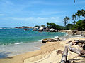 The Tayrona National Natural Park, a unique ecosystem.
 -
 Santa Marta Airport
 -
 Equestrian statue of Simón Bolívar
 -
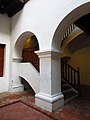 Casa de la Aduana
 -
 Santa Marta Port


- Gold Museum
- Casa de la Aduana
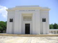
- Simón Bolívar National Memorial
- Quinta de San Pedro Alejandrino (National Sanctuary and Museum)
- Touristic, Cultural and Historic District of Santa Marta
- Ciudad Perdida (World Heritage Site)
- Ciénaga Grande de Santa Marta (flora and fauna sanctuary)
- Isla de Salamanca (natural monument)
- Sierra Nevada de Santa Marta National Park
- Tayrona National Natural Park
Sports
- Unión Magdalena Football Team that until c. 2005 that did not make the cut and was sent to the Colombian second division (Primera B). The team is nicknamed "el ciclón bananero" (The Banana Cyclone).
References
- ^ "Nuestro departamento: Información general: Geografía". Gobernación del Magdalena. Archived from the original on 29 June 2012.
- ISBN 978-0-8108-7813-6.
- ^ "DANE". Archived from the original on 13 November 2009. Retrieved 13 February 2013.
- ^ "Producto Interno Bruto por departamento", www.dane.gov.co
- ^ "Sub-national HDI - Area Database - Global Data Lab". hdi.globaldatalab.org. Retrieved 13 September 2018.
- ^ "Reloj de Población". DANE. Departamento Administrativo Nacional de Estadísitica. Archived from the original on 16 January 2018. Retrieved 6 July 2017.
External links
 | ||
| National | |
|---|---|
| Geographic | |