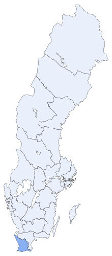
Malmöhus County
| Malmöhus County Malmöhus län | |||||||
|---|---|---|---|---|---|---|---|
| County of Sweden | |||||||
| 1719–1996 | |||||||
 | |||||||
| Capital | Malmö | ||||||
| History | |||||||
• Established | 1719 | ||||||
• Disestablished | 1996 | ||||||
| |||||||
Malmöhus County (
governor
originally lived.
History
Malmöhus County was part of
Skåne, Halland, Blekinge and Bohuslän provinces to Sweden[2] under the Treaty of Roskilde.[3] Denmark attempted to regain the lost provinces until 1710, but was unsuccessful.[4]
Geography
Malmöhus County was part of
Politics
Until the 1991 election, Malmöhus County had two Riksdag constituencies, while the current area has been divided into three. In the Malmöhus timeframe, the four cities of Helsingborg, Landskrona, Lund and Malmö formed a four-city constituency, while the rural areas formed the Malmöhus constituency. In 1994, the Malmö constituency was formed and the three other cities were divided into north-south redrawn boundaries. After the merger with Kristianstad County, these constituencies have been known as Skåne Southern and Skåne Western.
References
- ^ Axel Palmgren, Sweden A Guide For Tourists (Stockholm: Albert Bonniers Forlag, 1952), 169.
- ^ Palmgren, 169
- ^ L Russell Muirhead, ed. The Blue Guide Sweden (London: Ernest Benn Limited, 1952), 35.
- ^ Palmgren, 169-170
- ^ Axel Palmgren, Sweden A Guide for Tourists (Stockholm: Albert Bonniers Forlag, 1929), 168.
- ^ L. Russell Muirhead ed. The Blue Guide Sweden (London: Ernest Benn Limited, 1952), 35.
- ^ Muirhead, 35.
- ^ Palmgren, 168.
See also
- List of governors of Malmöhus County
- List of governors of Kristianstad County
- List of governors of Skåne County

