
Malta Freeport
| Malta Freeport | |
|---|---|
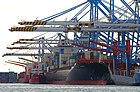
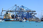
 View of the Malta Freeport | |
 Click on the map for a fullscreen view | |
| Location | |
| Country | Malta |
| Details | |
| Opened | 1988[1] |
| Operated by | Malta Freeport Terminals Ltd |
| Owned by | Malta Freeport Corporation Ltd |
| Land area | about 0.771 square kilometres (77.1 ha) |
| Statistics | |
| Vessel arrivals | 2,189[2] |
| Annual container volume | 3,060,000 TEU's[2] |
| Website http://www.maltafreeport.com.mt | |
Malta Freeport (Maltese: Il-Port Ħieles) is an international port on the island of Malta with a trade volume of 3.06 million TEUs in 2015.[2] Malta Freeport is one of busiest ports in Europe. The port is situated in Birżebbuġa in the southeastern part of Malta, on the site of the former seaplane base RAF Kalafrana.
Established in 1988, Malta Freeport was the first
Malta Freeport is the Mediterranean's third largest transshipment port. A planned expansion would increase its quay length on both terminals from the present operational length of 2.2 kilometres to over 3 kilometres and the total area (from 680,000) to 790,000 square metres (0.79 km2).[1]
-
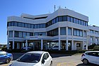 Freeport Centre
 -
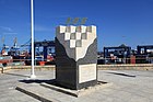 Freeport Monument
 -
-


_05_ies.jpg)
See also
References
- ^ a b About Us Archived 2010-09-18 at the Wayback Machine - Malta Freeport site
- ^ a b c Container Terminals, Traffic Archived 2014-12-11 at the Wayback Machine - Malta Freeport site
External links
35°49′05″N 14°32′24″E / 35.818°N 14.54°E
This Malta-related article is a stub. You can help Wikipedia by expanding it. |