
Manavgat River
| Manavgat River | |
|---|---|
 Manavgat River flowing over the Manavgat Waterfall | |
 | |
| Location | |
| Country | Turkey |
| Physical characteristics | |
| Mouth | |
• elevation | 1,350 m (4,430 ft) |
Manavgat River originates on the eastern slopes of Western
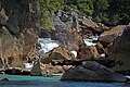
From there, the river flows south over conglomerated strata for about 90 km, descending through a series of canyons.[2] Finally, it washes over the Manavgat Waterfall and through the coastal plain and into the Mediterranean Sea. There are many caves in the river watershed area, the most interesting being the Altınbeşik cave.[4]
The maximum flow of the Manavgat River is 500 m³/second, with an average of 147 m³/second. Using the average flow as a measure, the Manavgat River accounts for a very small amount of the water flowing into the Mediterranean. There are two dams over the river:
In 1992, the Turkish State Hydraulics Work (DSI) was given the job of developing a water supply project for domestic use from the Manavgat river.[5]
-
 Oymapinar reservoir
 -
 Oymapinar reservoir of Manavgat
 -
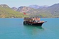
 Traditional cruise ships for Manavgat
 -
 Cruise ships for Manavgat
 -


Footnotes
- ^ Dictionary of Greek and Roman Geography (1854), William Smith, LLD, Ed., CILICIA
- ^ ISBN 0-89577-087-3.
- ^ Pliny. Naturalis Historia. Vol. 5.22.
- ^ "Manavgat River". turkeyodyssey. Archived from the original on 2008-06-02. Retrieved 2008-02-16.
- ^ a b "Manavgat River Water as a Limited but Alternative Water Resource for Domestic Use in Middle East" (PDF). Archived from the original (PDF) on 2008-02-27. Retrieved 2008-02-16.
- ISBN 9789027726322. Retrieved 2008-02-16.
See also
External links
36°43′N 31°28′E / 36.717°N 31.467°E
| Black Sea |
|
|---|---|
| Marmara | |
| Aegean | |
| Mediterranean Sea | |
| Persian Gulf | |
| Caspian |
|
This article related to a river in Turkey is a stub. You can help Wikipedia by expanding it. |