
Mandalay Region
Mandalay Region
မန္တလေးတိုင်းဒေသကြီး | |
|---|---|
| Myanma transcription(s) | |
| • Burmese | manta.le: tuing: desa. kri: |
|
| |
| • Religions | Buddhism 95.70%, Islam 3.00%, Christianity 1.10%, and Hinduism 0.2% |
| Time zone | UTC+06:30 (MST) |
| HDI (2017) | 0.570[3] medium · 5th |
| Website | www |
Mandalay Region (Burmese: မန္တလေးတိုင်းဒေသကြီး, pronounced [máɰ̃dəlé táiɰ̃ dèθa̰ dʑí]; formerly Mandalay Division) is an administrative division of Myanmar. It is located in the center of the country, bordering Sagaing Region and Magway Region to the west, Shan State to the east, and Bago Region and Kayin State to the south. The regional capital is Mandalay. To the south of the region lies the national capital of Naypyidaw. The division consists of eleven districts,[4] which are subdivided into 28 townships and 2,320 wards and village-tracts.
Mandalay Region is important in Myanmar's economy, accounting for 15% of the national economy. It is under the administration of the Mandalay Region Government.
History
The history of Mandalay Region is the same as that of much of Upper Myanmar except that for much of Burmese history, the political power emanated out of royal capitals located in Mandalay Region. The country's present capital, Naypyidaw, and most former royal capitals of the Burmese nation—Bagan, Ava, Amarapura, Mandalay—are all located here.

The
After the fall of Pagan to the
The
Administrative divisions
Before 2010, Mandalay Region consists of 8 districts. Later the Pyinmana district was formed as Union Territory under the direct administration of president. So Mandalay Region remains 28 townships organized into eleven districts.
Districts
Townships


Towns

- Mandalay
- Amarapura
- Pyinoolwin
- Thabeikkyin
- Tada-U
- Kyaukse
- Myingyan
- Meiktila
- Nyaung-U
- Yamethin
- Patheingyi
- Madaya
- Mogok
- Singu
- Ngazun
- Myittha
- Sintgaing
- Natogyi
- Taungtha
- Thazi
- Wundwin
- Mahlaing
- Kyaukpadaung
- Pyawbwe
- Myitnge
- Tagaung
- Kume
- Bagan
- Semekon
- Ngathayout
Government
Executive
During the ruling of junta, the region peace and development committee is the administrative body of Mandalay Region. In 2011, the new government form was introduced, and the Mandalay Region Government became the main administrative body of the region. The government is led by Chief Minister. The Government Office is located in Aungmyaythazan Township.

Legislature
In 2011, the State and Region Hluttaws were introduced in the new system. Each State and Region has a State Hluttaw or Regional Hluttaw made up of elected civilian members and unelected representatives of the Armed Forces. The number of seats in each State or Region Hluttaw depends on the number of townships (each township constituency has two MPs), as well as ethnic representatives. The Mandalay Region Hluttaw have 57 elected members (include one ethnic affairs minister) and 19 military representatives.[6]

Judiciary
Under the Mandalay Region High Court there are eight district courts, Mandalay, Pyin Oo Lwin, Kyaukse, Meithtila, Myingyan, Nyaung Oo, Yamethin and Dakina (for Union Territory). There are 35 township courts including the townships of Union Territory and 5 special courts.[7]
Demographics
| Year | Pop. | ±% |
|---|---|---|
| 1973 | 3,668,493 | — |
| 1983 | 4,577,762 | +24.8% |
| 2014 | 6,165,723 | +34.7% |
| Source: 2014 Myanmar census[2] | ||
The majority of the population in Mandalay Region are
Burmese is the primary language of the division. However, Mandarin Chinese is increasingly spoken in Mandalay and the northern gem mining town of Mogok.
Religion
According to the
According to the State Sangha Maha Nayaka Committee’s 2016 statistics, 99,964 Buddhist monks were registered in Mandalay Region, comprising 18.7% of Myanmar's total Sangha membership, which includes both novice samanera and fully ordained bhikkhu.[11] Mandalay Region is home to Myanmar's largest bhikkhu community. The majority of monks belong to the Thudhamma Nikaya (92.3%), followed by Shwegyin Nikaya (7.1%), with the remainder of monks belonging to other small monastic orders.[11] 8,174 thilashin were registered in Mandalay Region, comprising 13.5% of Myanmar’s total thilashin community.[11]
Economy
are also harvested.Education
Educational opportunities in Myanmar are extremely limited outside the main cities of Yangon and Mandalay. According to official statistics, over 1 million students were enrolled in the division's 4,467 primary and secondary schools in 2005.[1] Of the total, the vast majority, about 4,000, were primary schools. Only about 13% of primary school students make it to high school.[12]
| AY 2002–2003 | Primary | Middle | High |
|---|---|---|---|
| Schools | 4,011 | 231 | 113 |
| Teachers | 19,000 | 7,200 | 2,500 |
| Students | 690,000 | 259,000 | 91,000 |
The region has some of the best institutions of higher education in Myanmar. As medical, engineering and computer studies are the most sought after in Myanmar, the
Health care
The general state of health care in Myanmar is poor. The military government spends between 0.5% to 3% of the country's GDP on health care, consistently ranking among the lowest in the world.[13][14] Although health care is nominally free, in reality patients have to pay for medicine and treatment even in public clinics and hospitals. Public hospitals lack many of the basic facilities and equipment. The following is a summary of the public health system in the division, in the fiscal year 2002–2003.[15]
| 2002–2003 | # Hospitals | # Beds |
|---|---|---|
| Specialist hospitals | 7 | 1,725 |
| General hospitals with specialist services | 5 | 1,650 |
| General hospitals | 30 | 1,260 |
| Health clinics | 43 | 688 |
| Total | 85 | 5,323 |
In 2005, Mandalay Region's public health care system had slightly over 1,000 doctors and about 2,000 nurses working in 44 hospitals and 44 health clinics. Over 30 of the hospitals had less than 100 beds.[1] Since almost all of large public hospitals and private hospitals, and doctors are located in Mandalay, these low numbers for a division with 7.7 million are actually even worse in the rest of the division, though these figures are believed to have improved by the advent of Naypyidaw as the nation's capital in 2006 although the level of improvement remains unreported. The well-to-do bypass the public health system and go to private clinics in Mandalay or Yangon in order to receive quicker medical attention and high-quality service.[16] The wealthy routinely go abroad (usually Bangkok or Singapore) for treatment.[17]
Gallery
-
 Thaungthaman Lake
 -
 Sunset from Mandalay Hill
 -
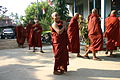 Monks at Buddhist Temple
 -
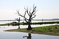
 Sunset from U Bain bridge
 -
 Mt. Popa
 -
 Mandalay Hill, Moat
 -
 Pyin Oo Lwin National Kandawgyi Garden
 -
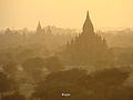 Bagan
Bagan


_-_panoramio.jpg)

See also
References
- ^ a b c Thiha Aung (2005-02-13). "Mandalay Division marching to new golden land of unity and amity". The New Light of Myanmar.
- ^ a b Census Report. The 2014 Myanmar Population and Housing Census. Vol. 2. Naypyitaw: Ministry of Immigration and Population. May 2015. p. 17.
- ^ "Sub-national HDI – Area Database – Global Data Lab". hdi.globaldatalab.org. Retrieved 2018-09-13.
- ^ "မန္တလေးတိုင်းဒေသကြီးအတွင်းရှိ ခရိုင်အမည်များ တိုးချဲ့ပြင်ဆင်ဖွဲ့စည်းခြင်း" (in Burmese).
- ^ "Myanmar Divisions". Statoids. Retrieved 2009-04-10.
- ^ "About". Mandalay Region Hluttaw.
- ^ "မန္တလေးတိုင်းတရားလွှတ်တော်အကြောင်း". Mandalay Region Government.
- ^ Stephen Mansfield (1999-05-13). "Myanmar's Chinese connection". The Japan Times.
- ^ Department of Population Ministry of Labour, Immigration and Population MYANMAR (July 2016). The 2014 Myanmar Population and Housing Census Census Report Volume 2-C. Department of Population Ministry of Labour, Immigration and Population MYANMAR. pp. 12–15.
- ^ a b The 2014 Myanmar Population and Housing Census Census Report Volume 2-C (PDF). Department of Population Ministry of Labour, Immigration and Population. July 2016. pp. 12–15.
- ^ a b c "The Account of Wazo Monks and Nuns in 1377 (2016 year)". State Sangha Maha Nayaka Committee. 2016. Retrieved 2021-01-19.
- ^ "Education statistics by level and by State and Division". Myanmar Central Statistical Organization. Archived from the original on 2008-05-24. Retrieved 2009-04-09.
- ^ "PPI: Almost Half of All World Health Spending is in the United States". 2007-01-17. Archived from the original on 2008-02-05.
- ^ Yasmin Anwar (2007-06-28). 06.28.2007 "Burma junta faulted for rampant diseases". UC Berkeley News.
{{cite news}}: Check|url=value (help) - ^ "Hospitals and Dispensaries by State and Division". Myanmar Central Statistical Organization. Archived from the original on 2011-04-30. Retrieved 2009-04-11.
- ^ Aye Lei Tun (2007-06-11). "Mandalay continues to play vital role as healthcare centre for the upper north". The Myanmar Times. Archived from the original on 2008-07-20. Retrieved 2009-01-24.
- ^ Thein Win Nyo (2007-06-11). "Medical tourism gives patients options". The Myanmar Times. Archived from the original on 2008-07-20.
External links
Places adjacent to Mandalay Region | |
|---|---|
Capital: Mandalay | ||
| Kyaukse District |   | |
| Mandalay District | ||
| Meiktila District | ||
| Myingyan District | ||
| Nyaung-U District | ||
Pyinoolwin District | ||
| Yamethin District | ||
| Main cities and towns | ||
| States | ||
|---|---|---|
| Regions | ||
| Self-Administered Zones | ||
| Self-Administered Divisions | ||
| Union Territories | ||
| National | |
|---|---|
| Geographic | |