
Mandya
This article needs additional citations for verification. (August 2015) |
Mandya | |
|---|---|
City | |
UTC+5:30 (IST) | |
| PIN | 571401[3] |
| Vehicle registration | KA-11, KA-54 |
| Website | http://www.mandyacity.mrc.gov.in/en |
Mandya is a city in the state of Karnataka. It is the headquarter of Mandya district and is located 45 kilometres (28 mi) from Mysore and 100 kilometres (62 mi) from Bangalore.
Sugar factories contribute to the major economic output. It is also called Sugar City (Kannada: Sakkare Nagara) because sugarcane is a major crop grown here. The district offices are located here. The city has been divided into 35 wards of the Mandya City Municipal Council.
History
Mandya celebrated its 75th year anniversary (Amrutha Mahothsava) in 2015. The KRS dam was built by Krishna Raja Wadiyar IV and M. Visvesvaraya in Mandya, opening in 1932. Mandya is home to a number of historically important sites. In 2016, Archaeological Survey of India (ASI) excavated another 13 ft (4.0 m) statue of Bahubali, a much revered figure among Jains. He was the son of Adinath, the first tirthankara of Jainism, and the younger brother of Bharata Chakravartin, identified with the 3rd – 9th centuries in Arthipura, Mandya district. The excavation is expected to be completed by 2018.[4][needs update] The Archaeological Survey of India has also excavated an 8th-century statue of Bahubali in Arthipura, Maddur, Mandya, Karnataka, that is 3 ft (0.91 m) feet wide and 3.5 ft (1.1 m) tall.[5]
Transport
The Mandya railway station is located in the city centre, well connected to Mysuru and Bengaluru. There are daily train services to
Geography
Mandya is located at 12°31′N 76°54′E / 12.52°N 76.9°E.[7] It has an average elevation of 678 metres (2,224 ft).
Demographics
As per the 2011 India census, Mandya had a population of 137,358. The sex ratio is 1000 females per 1000 males, higher than the state average of 973. Mandya has an average literacy rate of 85.32%, higher than the state average of 75.36%: male literacy is 89.39%, and female literacy is 81.29%. 10.14% of the population is under 6 years of age.
Scheduled Castes constitute 13.40% while Scheduled Tribes constitute 1.17 % of the total population of Mandya (CMC).[8]
Climate
| Climate data for Mandya (1981–2010, extremes 1972–2012) | |||||||||||||
|---|---|---|---|---|---|---|---|---|---|---|---|---|---|
| Month | Jan | Feb | Mar | Apr | May | Jun | Jul | Aug | Sep | Oct | Nov | Dec | Year |
| Record high °C (°F) | 35.6 (96.1) |
36.2 (97.2) |
37.8 (100.0) |
38.6 (101.5) |
39.1 (102.4) |
37.9 (100.2) |
34.4 (93.9) |
33.6 (92.5) |
35.1 (95.2) |
33.5 (92.3) |
32.8 (91.0) |
36.6 (97.9) |
39.1 (102.4) |
| Mean daily maximum °C (°F) | 29.7 (85.5) |
32.3 (90.1) |
34.5 (94.1) |
35.1 (95.2) |
34.1 (93.4) |
30.7 (87.3) |
29.5 (85.1) |
29.2 (84.6) |
30.2 (86.4) |
29.7 (85.5) |
29.0 (84.2) |
28.5 (83.3) |
31.0 (87.8) |
| Mean daily minimum °C (°F) | 15.2 (59.4) |
16.9 (62.4) |
19.3 (66.7) |
21.4 (70.5) |
21.3 (70.3) |
20.1 (68.2) |
19.9 (67.8) |
19.6 (67.3) |
19.4 (66.9) |
19.4 (66.9) |
18.0 (64.4) |
15.6 (60.1) |
18.8 (65.8) |
| Record low °C (°F) | 8.0 (46.4) |
9.0 (48.2) |
11.8 (53.2) |
15.0 (59.0) |
11.7 (53.1) |
12.1 (53.8) |
15.0 (59.0) |
12.2 (54.0) |
12.7 (54.9) |
12.3 (54.1) |
10.1 (50.2) |
8.1 (46.6) |
8.0 (46.4) |
| Average rainfall mm (inches) | 1.0 (0.04) |
4.4 (0.17) |
18.8 (0.74) |
42.0 (1.65) |
83.8 (3.30) |
61.1 (2.41) |
52.1 (2.05) |
76.5 (3.01) |
129.4 (5.09) |
157.4 (6.20) |
52.3 (2.06) |
14.1 (0.56) |
693.0 (27.28) |
| Average rainy days | 0.2 | 0.3 | 1.1 | 3.0 | 5.1 | 3.7 | 4.6 | 5.5 | 6.9 | 7.9 | 3.9 | 1.1 | 43.0 |
| Average relative humidity (%) (at 17:30 IST )
|
47 | 39 | 34 | 43 | 52 | 66 | 71 | 70 | 66 | 67 | 64 | 56 | 57 |
| Source: India Meteorological Department[9][10] | |||||||||||||
Gallery
-
 DC office
 -
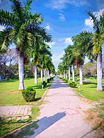 Kaveri park
 -
 Horticulture department, where the 'Phala Pushpa Pradarshana' happens every year in Mandya
 -
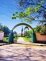
 Entrance of Carmel convent school, Mandya
 -
 Court complex
 -
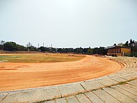 Vishveshwaraiah stadium


See also
- Tourist Attractions in Mandya
References
- ^ "City summary".
- ^ "Census Data Handbook 2011" (PDF). Retrieved 3 August 2023.
- ^ "Pin Code". citypincode.pk. Retrieved 6 May 2016.
- ^ Girish, M. B. (23 February 2016) [4 December 2015], "Another Jain centre under excavation in Mandya district", Deccan Chronicle
- ^ "Eighth Century Jain Temple Discovered in Maddur", The New Indian Express, Express News Service, 7 January 2015, archived from the original on 10 January 2015
- ^ "Sugar industry". karnataka.com. Retrieved 6 May 2016.
- ^ "Falling Rain Genomics, Inc - Mandya". fallingrain.com. Retrieved 6 May 2016.
- ^ "Census of India 2011". Census Commission of India.
- ^ "Station: Mandya Climatological Table 1981–2010" (PDF). Climatological Normals 1981–2010. India Meteorological Department. January 2015. pp. 473–474. Archived from the original (PDF) on 5 February 2020. Retrieved 19 April 2020.
- ^ "Extremes of Temperature & Rainfall for Indian Stations (Up to 2012)" (PDF). India Meteorological Department. December 2016. p. M100. Archived from the original (PDF) on 5 February 2020. Retrieved 18 April 2020.
External links
| International | |
|---|---|
| National | |