
Manganese, Minnesota
Manganese | |
|---|---|
UTC−5 (CDT) | |
| GNIS feature ID | 654881[1] |
Manganese is a
Manganese was one of the last of the Cuyuna Range communities to be established, and was named after the mineral located in abundance near the town. Manganese was an incorporated community, built on land above the Trommald Formation, the main ore-producing unit of the North Range district of the Cuyuna Iron Range, unique due to the amount of manganese in part of the iron formation and ore. The Trommald Formation and adjacent Emily District are the largest resource of manganese in the United States. The community was composed of many immigrants who had fled the natural disasters and social and political upheavals in Europe during the decades before World War I.
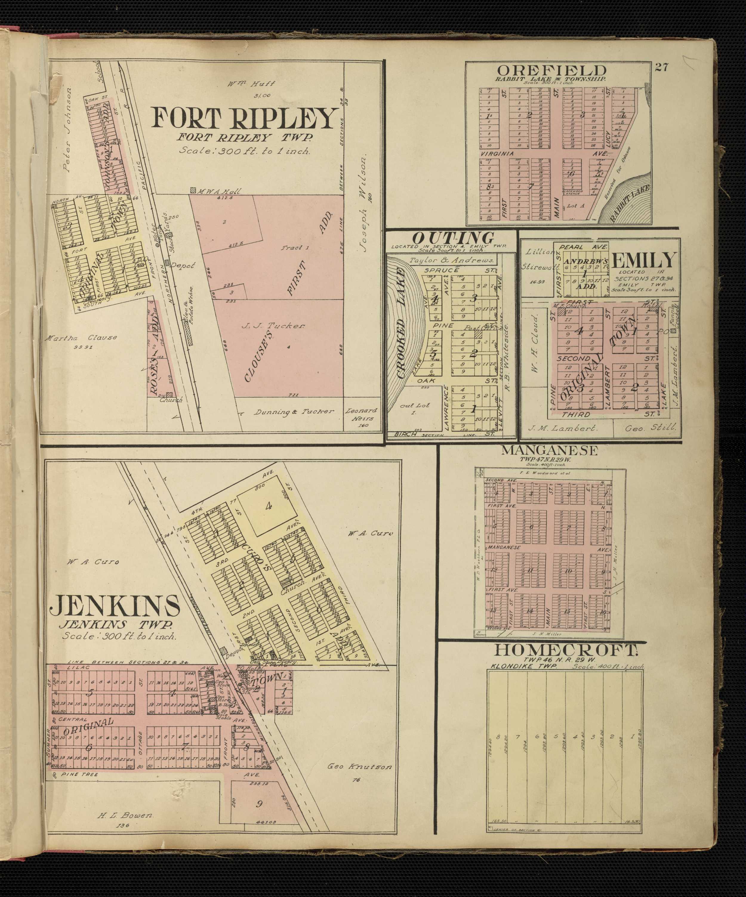
Manganese was laid out with three north–south and five east–west streets. Concrete sidewalks and curbing lined the clay streets, which were never paved. At its peak around 1919, Manganese had two hotels, a bank, two grocery stores, a barbershop, a show hall, and a two-room school, and housed a population of nearly 600. After World War I, the population of Manganese went into steady decline as mining operations shut down; along with the quagmire of the clay streets due to spring rains, this led to the community's eventual abandonment and formal dissolution in 1961. The privately owned land started to be resettled in 2017, as the old wooded lots were cleared and redeveloped as primitive campsites.
History
The area around Manganese, and modern-day Crow Wing County, was inhabited in the mid-to-late 1600s by three distinct populations of Native Americans vying for control of the lands that would become the Cuyuna Range. The Arapaho living along the western border of the Great Lakes were quickly displaced by the Dakota and Ojibwe nations; frequent conflicts between the Dakota and Ojibwe eventually resulted in undisputed control of the region by the Ojibwe. In 1855, a treaty between the Ojibwe and the U.S. government was signed by chief Hole in the Day in what was then Minnesota Territory. This treaty secured Ojibwe hunting and fishing rights while ceding land which would become the Cuyuna Range to European-Americans looking to build new settlements in the region.[2] The Minnesota Territorial Legislature enacted the creation of Crow Wing County on May 23, 1857.[3] Minnesota was admitted as the 32nd U.S. state on May 11, 1858, and Deerwood (originally named Withington), was the first Cuyuna Range community, settled in 1871.[4][5]
The discovery of the Cuyuna Iron Range was an accident, made by the chance observation of a
Establishment and community

Manganese was
An official U.S. Post Office opened in 1912 and remained in operation through 1924.[12] In 1914, the town site had a crew of men and teams building streets with concrete sidewalks and curbing (although the clay roads were never paved).[23] The Fitger Brewing Company also built a $10,000, two-story hotel in 1914, complete with a bar and restaurant. By 1919, Manganese had two hotels, a bank, two grocery stores, two butcher shops, a lumber yard, a bakery, a livery stable, a barbershop, a pool room, a show hall, a dog pound, and a two-room school, and housed a population of nearly 600.[13][24][25] That same year, the village issued a bond for a $30,000 waterworks project, and the Pastoret Company of Duluth built a 100-foot (30 m) water tower with a 30,000-US-gallon (110,000 L) capacity.[26][27][28] Manganese and other Cuyuna Range communities benefited greatly from an unusual situation created by an ad valorem property tax on unmined natural ore,[29] resulting in huge amounts of unforeseen revenue, great expenditures of which were made on public works and improvements.[30]

After the discovery of ore near Deerwood, Adams approached
The community was composed of many immigrants, including Finns, Croatians, Austrians, Swedes, Irish, Australians, English, Norwegians, Slovenians, and Serbs.[24][38] Children attended school in Manganese through the eighth grade, attending high school in nearby Crosby, Minnesota. Known then as Independent School District No. 86,[39] the school had indoor plumbing and later its own well, constructed by the Works Progress Administration.[24][40] Over time, the village of Manganese had three wells, all of which collapsed at some point due to the heavy clay soils.[24]
During late World War I, all of the mines surrounding the community were running at full capacity, furnishing about 90% of the manganese used during the war. By 1920, the combined payrolls of these mines totaled $160,000 (approximately $9.6 million in adjusted 2020 production worker compensation).[13][25][41] Seven citizens from Manganese served in the military during World War I, including Harry Hosford,[42] who later survived the Milford mine disaster.
Decline
After the World War I armistice was signed, the demand for manganiferous ore decreased, and Manganese experienced a sharp drop in population from its peak of nearly 600 in 1919 to 183 in 1920.[25][37][43] Many of the remaining residents worked in the Milford mine, which flooded on February 5, 1924, a result of blasting in a drift that extended beneath Foley (now Milford) Lake. Forty-one miners were killed in what was Minnesota's worst mining disaster; only seven, including Hosford, made it to safety.[44][45] Many Manganese residents were superstitious and convinced that both the town of Manganese, and the Milford mine, were cursed.[46]

With the advent of the Great Depression, mining operations ceased. The Soo Line tore up the track to Manganese in 1930.[24][28] The last shipment of ore from the Gloria mine occurred in 1931; the Milford mine closed in 1932, although the Merritt mine continued to produce ore intermittently until 1943, and stockpile shipments from the Algoma mine continued through 1980.[44][48][49] Very few photos of Manganese are known to exist. Never a wealthy community, residents had no money for cameras, a luxury item during the Depression.[24]
In 1938, a Wesleyan Methodist Church and Sunday school was founded. Up to four Sunday school classes were offered depending on the ages of the children, and guest pastors would come to conduct services when occasional revival meetings were held. The congregation came from Trommald, Mission, Wolford, and Perry Lake, in addition to Manganese. The church was sold and torn down after World War II when the congregation was no longer able have a pastor appointed.[50] As mining operations began to shut down, little employment was left in the community, and residents gradually started moving their homes out of town, relocating to other communities in the region to find new jobs.[51]
Abandonment and later use
| Census | Pop. | Note | %± |
|---|---|---|---|
| 1920 | 183 | — | |
| 1930 | 96 | −47.5% | |
| 1940 | 62 | −35.4% | |
| 1950 | 41 | −33.9% | |
| U.S. Decennial Census[52] | |||
Most of the remaining residents moved out around 1955.

After the town was abandoned, only remnants of sidewalks, rubble, building foundations, old tires, plastic, pieces of clothing, beer cans, and other abandoned items remained.[28][60] Willow, aspen, and other trees covered what was once a land occupied by numerous buildings; roots, shrubs, and grass began to heave and crack the concrete sidewalks and overtake the remaining grid pattern of roads, and the entire town site was consumed by the steady growth of natural vegetation. Most of the remaining structures succumbed to the elements. Old building foundations and basements, covered with graffiti, were engulfed by the brush.[60] In 2003, the majority of the land which comprised the former town site was purchased, and a gate was posted along with a "no trespassing" sign at the southeast entrance to the former town. In 2006, the privately owned land was sold again; limited resettlement began in 2017.[61] Called Manganese Base Camp, the old wooded lots, about 0.3 acres (0.12 ha) each, were being cleared and redeveloped as primitive campsites, without electricity, running water, or waste disposal services. Since then, Base Camp has hosted an annual Manganese Days Festival. The event is open to the public as a way to honor the former village, learn of its history, and explore the old town.[62]
Geography
Manganese lay at an elevation of 1,250 feet (380 m) in Crow Wing County, Minnesota, about 15 miles (24 km) northeast of Brainerd and 91 miles (146 km) west-southwest of Duluth.[1][63] The nearest cities to Manganese were Trommald, approximately 2 miles (3 km) to the south-southwest, and Wolford, approximately 2 miles (3 km) to the northeast.[35] Manganese was located to the west of Crow Wing County Road 30, about 5 miles (8 km) north of Minnesota State Highway 210 and 3 miles (5 km) west of Minnesota State Highway 6.[64]
Manganese was laid out with three primary north–south streets: First Street East, Main Street, and First Street West. Second Avenue North, First Avenue North, Manganese Avenue, First Avenue South (now Old Manganese Road), and Second Avenue South traversed Manganese from east to west.[65] The Soo Line right of way bisected the community on the east side of Manganese from the northeast to the southwest.[25][66] First Avenue North extended about 1.9 miles (3.1 km) to the Milford mine.[67]
Geology
Manganese lay atop the iron-rich Trommald Formation, the main ore-producing unit of the North Range district of the Cuyuna Iron Range.[68]
The Trommald Formation and adjacent Emily District are the largest resource of manganese in the United States.[63][69][70] The largest high-grade deposit of manganiferous ore is located about 14 miles (23 km) north of Manganese on a 5-acre (2.0 ha) site at the edge of Emily.[71][72] Valuable in steel and aluminum production, manganese is also used to make batteries.[73][74] There is a local push to "scram"[75] the stockpiles of ore found in the old waste rock of the Cuyuna Iron Range. This mining process is significantly less invasive than traditional blasting and crushing, producing iron ore and iron ore concentrates from previously developed waste rock stockpiles, tailings basins, open pit, or underground mines on land not previously affected by mining. However, the processing of some stockpiles would disrupt the Cuyuna Lakes Mountain Bike Trails,[76] which opened in June 2011,[77] and have been economically beneficial to the region after the last manganiferous ore was shipped from the Cuyuna Range in 1984, resurrecting many Cuyuna Range communities that had been on the brink of economic collapse.[6][78] This potential for ore processing has created debate as to whether mining and mountain biking can coexist.[79] The use of former underground Cuyuna Range mines as a means of compressed-air energy storage has also been investigated by researchers at the University of Minnesota.[80]
Climate
Manganese was in the
July is the warmest month, when the average high temperature is 80 °F (27 °C) and the average low is 56 °F (13 °C). January is the coldest, with an average high temperature of 20 °F (−7 °C) and average low of 0 °F (−18 °C).[82] The spring rains wreaked havoc on Manganese's clay streets, which was cited as one of the reasons for its abandonment.[24][28]
See also
- Iron Range
- List of ghost towns in the United States
References
- ^ a b c "Manganese". Geographic Names Information System. United States Geological Survey. Archived from the original on August 1, 2021. Retrieved March 29, 2020.
- ^ Sutherland 2016, pp. 47, 48, 50, 51.
- ^ "Crow Wing County History & Facts". Crow Wing County, Minnesota. Archived from the original on January 28, 2021. Retrieved August 1, 2021.
- ^ Cuyuna Iron Range Heritage Network (March 2022). "Deerwod is 150 Years Old". Newsletter: 3.
- ^ "About Deerwood". City of Deerwood, Minnesota. Archived from the original on March 20, 2022. Retrieved March 31, 2022.
- ^ Minneapolis Star Tribune. Archivedfrom the original on August 15, 2021. Retrieved August 15, 2021.
- ^ a b Clark, Neil M. (February 1922). "How the Needle of a Compass Pointed the Way to Fortune". The American Magazine. 93. New York: The Crowell Publishing Company: 86–93. Archived from the original on April 28, 2016. Retrieved April 4, 2020.
- ^ Havinghurst 1958, pp. 75–76.
- ^ Borchert 1959, p. 64.
- ^ Upham 2001, p. 158.
- ^ Himrod c. 1944, p. 45.
- ^ a b c Upham 2001, p. 160.
- ^ a b c d Village of Manganese. "Welcome Letter". Archival Material, File: Manganese, Minnesota. Crosby, Minnesota: Cuyuna Iron Range Heritage Network.
- ^ Hansen 1976, p. 48.
- ^ a b Duluth Land and Timber Co. "Newspaper Clipping". Archival Material, File: Manganese, Minnesota. Crosby, Minnesota: Cuyuna Iron Range Heritage Network.
- ^ Minnesota Historical Records Survey Project 1940, pp. 110, 114, 117, 119.
- ^ Lake Superior Iron Ore Association 1952, pp. 29, 31, 36, 38.
- hdl:11299/59306. Archivedfrom the original on September 6, 2015. Retrieved August 9, 2020.
- ^ Upham 2001, pp. 157, 158, 159, 162.
- ^ Sutherland 2016, p. 11.
- ^ "Hibbing History". Hibbing Chamber of Commerce. Archived from the original on March 5, 2021. Retrieved August 12, 2021.
- ^ "Facts and History". City of Hibbing. Archived from the original on May 15, 2021. Retrieved August 12, 2021.
- ^ a b "Manganese a Busy Town". Brainerd Dispatch. July 3, 1914. p. 5.
- ^ a b c d e f g h Sloan, Jim (May 8, 1985). "Manganese Revisited". Brainerd Dispatch. pp. 1N, 3N.
- ^ a b c d e Welton, Jim (Winter 1993). "Soo Line's Cuyuna Range Ore Operations Part 3: The Communities of the Cuyuna Range". The Soo. 15 (1). Appleton, Wisconsin: The Soo Line Historical and Technical Society: 9–28.
- ^ Village of Manganese. "1919 Waterworks Bond". Archival Material, File: Manganese, Minnesota. Crosby, Minnesota: Cuyuna Iron Range Heritage Network.
- ^ Foote, L. L. (March 24, 1954). "Manganese – Ghost Town". Crosby-Ironton Courier. p. 1.
- ^ a b c d Cuyuna Country Heritage Preservation Society 2002, p. 190.
- ^ Roberts, David R. (April 1950). "Tax Valuation of Minnesota Iron Ore". Minnesota Law Review. 34 (5). Minneapolis: University of Minnesota: 400. Archived from the original on August 1, 2021. Retrieved August 5, 2020.
- ^ a b "Nomination Form: Cuyuna Iron Range Municipally-Owned Elevated Metal Water Tanks Thematic Resources" (PDF). National Register of Historic Places. 1979. Retrieved February 22, 2007.
- ^ Sutherland 2016, pp. 65, 78.
- ^ Schmidt, Andrew J.; Pratt, Daniel R.; Vermeer, Andrea C.; Bradley, Betsy H. (2013). "Railroads in Minnesota, 1862–1956 MPS, Section E" (PDF). National Register of Historic Places. p. 113. Archived (PDF) from the original on April 14, 2021. Retrieved August 1, 2021.
- ^ "New Soo Depot for Manganese". Brainerd Dispatch. August 7, 1914. p. 5.
- ^ Leighton 1998, p. 19.
- ^ a b Welton, Jim (October 1992). "Soo Line's Cuyuna Range Ore Operations Part 2: The Cuyuna Range Line Becomes Operational". The Soo. 14 (4). Appleton, Wisconsin: The Soo Line Historical and Technical Society: 13–29.
- ^ "Henry Ford's Private Railroad Car "Fair Lane", 1921". The Henry Ford. Archived from the original on November 6, 2016. Retrieved July 3, 2020.
- ^ a b Anon. Archival Material, File: Manganese, Minnesota. Crosby, Minnesota: Cuyuna Iron Range Heritage Network.
- ^ Sutherland 2016, pp. 89, 90, 94.
- ^ Himrod c. 1944, p. 35.
- ^ a b Cuyuna Country Heritage Preservation Society 2002, p. 191.
- ^ Williamson, Samuel H. (2020). "Seven Ways to Compute the Relative Value of a U.S. Dollar Amount, 1790 to present". Measuring Worth. Archived from the original on October 22, 2018. Retrieved October 12, 2021.
- ^ Minnesota War Records Commission. "Manganese, Minnesota". World War I Military Service Records, 1918–1920. St. Paul, Minnesota: Minnesota Historical Society. Retrieved July 27, 2017.
- ^ Census 1922, p. 238.
- ^ a b Fitzgerald, John (October 31, 2013). "Milford Mine Disaster, 1924". MNopedia. Minnesota Historical Society. Archived from the original on September 14, 2016. Retrieved April 1, 2020.
- ^ Sutherland 2016, pp. 5, 22, 144, 231.
- ^ Jones, Hannah (September 16, 2019). "The ghostly legacy of Minnesota's Milford Mine disaster". City Pages. Archived from the original on October 14, 2019. Retrieved July 25, 2020.
- ^ Anon. "Manganese Original Owners, Block and Lot Descriptions". Archival Material, File: Manganese, Minnesota. Crosby, Minnesota: Cuyuna Iron Range Heritage Network.
- ^ Schmidt 1963, pp. 67, 68, 69.
- ^ Welton, Jim (Spring 1993). "Soo Line's Cuyuna Range Ore Operations Part 4: The Mines of the Cuyuna Range". The Soo. 15 (2). Appleton, Wisconsin: The Soo Line Historical and Technical Society: 10–16.
- ^ Cuyuna Country Heritage Preservation Society 2002, p. 193.
- ^ Sutherland 2016, pp. 186, 240.
- ^ United States Census Bureau. "Census of Population and Housing". Archived from the original on July 19, 2018. Retrieved May 10, 2019.
- ^ Sutherland 2016, p. 186.
- ^ Radinovich, Mary. "Personal Correspondence". Archival Material, File: Manganese, Minnesota. Crosby, Minnesota: Cuyuna Iron Range Heritage Network.
- ^ Bergan & Lammi 2015, p. 101.
- ^ a b Manganese, Minnesota. "Crow Wing County: Manganese". Records, 1913–1960. St. Paul, Minnesota: Minnesota Historical Society. Retrieved October 27, 2017.
- ^ Sutherland 2016, p. 212.
- ^ Census 1964, p. 26.
- ^ "Landview". Minnesota Department of Natural Resources. Archived from the original on July 15, 2017. Retrieved March 24, 2020.
- ^ a b Perrine, Jessie (August 14, 2014). "Manganese–Local Ghost Town". Brainerd Dispatch. p. W4.
- ^ "Property Information". Crow Wing County, Minnesota. Archived from the original on December 28, 2019. Retrieved July 2, 2020.
- ^ "Manganese Base Camp". Manganese Base Camp. Archived from the original on March 30, 2020. Retrieved March 30, 2020.
- ^ hdl:11299/122265. Archivedfrom the original on September 6, 2015. Retrieved April 2, 2020.
- ^ Minnesota Official Highway Map (Map). [1:760,320]. Minnesota Department of Highways. 1960. Archived from the original on December 7, 2017. Retrieved December 6, 2017.
- ^ Standard Atlas, Crow Wing County, Minnesota (Map). [1:4,800]. Chicago: Geo. A. Ogle & Co. 1913. Archived from the original on September 7, 2015. Retrieved April 5, 2020.
- ^ "Crow Wing County GIS Public Map Service". Crow Wing County, Minnesota. Archived from the original on March 24, 2020. Retrieved April 14, 2020.
- ^ Terrell, Michelle M.; Gronhovd, Amanda (March 2015). Milford Mine National Register Historic District, Crow Wing County, Minnesota: Cultural Landscape Report (Report). Crow Wing County, Minnesota. p. 51. Archived from the original on August 1, 2021. Retrieved April 14, 2020.
- hdl:11299/60800. Archivedfrom the original on March 30, 2020. Retrieved March 30, 2020.
- ^ Robertson, Tom (June 4, 2009). "Underground in Emily, a mother lode of manganese". Minnesota Public Radio. Archived from the original on August 1, 2021. Retrieved March 30, 2020.
- ^ Sutherland 2016, p. 4.
- ^ Johnson, Brooks; Lovrien, Jimmy (September 1, 2018). "Minnesota manganese deposit sits untapped despite growing market". Duluth News Tribune. Archived from the original on October 13, 2019. Retrieved April 22, 2020.
- ^ "Crow Wing Power announces partnership to develop Emily manganese deposit". Brainerd Dispatch. June 7, 2019. Archived from the original on August 1, 2021. Retrieved April 22, 2020.
- ^ Burton, Michael; Egan, Kevin (January 2015). "Bringing Mining Back to the Cuyuna Range?" (PDF). Laurentian Vision Project. Brainerd Lakes Area Economic Development Corporation. p. 18. Archived (PDF) from the original on August 1, 2021. Retrieved March 30, 2020.
- ^ Sutherland 2016, pp. 184, 243.
- ^ "Minnesota Statutes 2020, Mineral Lands, Land Reclamation". Section 93, Subdivision No. 10 of 2020. Minnesota Legislature Revisor of Statutes. p. 28. Archived from the original on August 13, 2021. Retrieved August 12, 2021. Archived August 13, 2021, at the Wayback Machine
- ^ "Cuyuna Mountain Bike Trail System". Minnesota Department of Natural Resources. Archived from the original on December 9, 2018. Retrieved April 2, 2020.
- ^ "Brainerd MN Bike Trails: Cuyuna Mountain Bike Trail System". Brainerd.com. Archived from the original on June 24, 2020. Retrieved August 11, 2020.
- ^ Rosemore, Lisa (February 28, 2014). "Cuyuna: The Lost Range". Hibbing Daily Tribune. Archived from the original on April 26, 2016. Retrieved March 31, 2020.
- ^ Richardson, Renee (July 12, 2014). "Mining, mountain biking come head to head on Cuyuna Range". Inforum. Forum Communications Company. Archived from the original on August 1, 2021. Retrieved April 15, 2020.
- ^ Fosnacht, D. R.; Wilson, E. J.; Marr, J. D.; Carranza-Torres, C.; Hauck, S. A.; Teasley, R. L. (2015). Compressed-Air Energy Storage (CAES) in Northern Minnesota Using Underground Mine Workings and Above Ground Features (PDF) (Report). University of Minnesota Duluth: Natural Resources Research Institute. Archived (PDF) from the original on July 13, 2017. Retrieved March 30, 2020.
- ^ "Laurentian Mixed Forest Province". Minnesota Department of Natural Resources. Archived from the original on May 20, 2014. Retrieved May 23, 2014.
- ^ "Manganese, MN Monthly Weather". The Weather Channel. Archived from the original on August 1, 2021. Retrieved April 1, 2020.
Sources
- Bergan, Kathleen M.; Lammi, Michelle M. (2015). Iron Range Ghost Locations. OCLC 946962834.
- Borchert, John R. (1959). Minnesota's Changing Geography. Minneapolis: ISBN 978-0-8166-6839-7. Archivedfrom the original on August 10, 2021. Retrieved July 5, 2020.
- Cuyuna Country Heritage Preservation Society (2002). Cuyuna Country: A People's History. Vol. II (First ed.). Brainerd, Minnesota: Bang Printing Company. ISBN 978-0-9677450-0-8.
- Hansen, Arvy (1976). Cuy-Una! A Chronicle of the Cuyuna Range. Crosby, Minnesota: Cuyuna Range Bicentennial Committee. ASIN B0006XIW3I.
- Havinghurst, Walter (1958). Vein of Iron: The Pickands-Mather Story. ASIN B0007DMAS0. Archivedfrom the original on June 9, 2021. Retrieved November 5, 2013.
- Himrod, Anna (c. 1944). Historical Handbook, Crow Wing County Histories. OCLC 313860231.
- Klemic, Harry (1970). Survey of World Iron Resources: Iron Ore Deposits of the United States of America, Puerto Rico, Mexico and Central America. New York: OCLC 105522.
- Lake Superior Iron Ore Association (1952). Lake Superior Iron Ores: Mining Directory and Statistical Record of the Lake Superior Iron Ore District of the United States and Canada (Second ed.). Cleveland: Lake Superior Iron Ore Association. OCLC 1025093.
- Leighton, Hudson (1998). Gazetteer of Minnesota Railroad Towns, 1861–1997. ISBN 978-0-915709-61-8. Archivedfrom the original on June 9, 2021. Retrieved July 27, 2017.
- Minnesota Historical Records Survey Project (1940). The Cuyuna Range: A History of a Minnesota Iron Mining District. St. Paul, Minnesota: Works Progress Administration Division of Professional and Service Projects. ASIN B07HV921QQ. Archivedfrom the original on August 10, 2021. Retrieved August 12, 2020.
- Morey, G. B. (1990). Geology and Manganese Resources of the Cuyuna Iron Range, East-Central Minnesota (PDF) (Report). St. Paul, Minnesota: Minnesota Geological Survey. (PDF) from the original on August 8, 2017. Retrieved March 30, 2020.
- Schmidt, Robert Gordon (1963). Geology and Ore Deposits of the Cuyuna North Range Minnesota (PDF) (Report). ISBN 978-1-288-96476-5. Archived(PDF) from the original on May 2, 2019. Retrieved March 30, 2020.
- Sutherland, Frederick (2016). The Cuyuna Iron Range: Legacy of a 20th Century Industrial Community (PhD thesis). from the original on July 14, 2020. Retrieved July 13, 2020.
- ISBN 978-1-396-46429-4. Archived(PDF) from the original on September 21, 2013. Retrieved May 10, 2019.
- United States, Bureau of the Census (1964). U.S. Census of Population, 1960 (PDF). Vol. I, Pt. 25. Washington: Government Printing Office. ISBN 978-1-390-26083-0. Archived(PDF) from the original on June 9, 2011. Retrieved May 10, 2019.
- Upham, Warren (2001). Minnesota Place Names: A Geographical Encyclopedia (Third ed.). St. Paul, Minnesota: Minnesota Historical Society. ISBN 978-0-87351-396-8. Archivedfrom the original on June 9, 2021. Retrieved July 27, 2017.
Further reading
- Brightman, George F. (July 1942). "Cuyuna Iron Range". JSTOR 141127. Retrieved August 16, 2021.
External links
Municipalities and communities of Crow Wing County, Minnesota, United States | ||
|---|---|---|
| Cities |  | |
| Townships | ||
| Unorganized territories | ||
| CDP | ||
| Unincorporated communities | ||
| Indian reservation | ||
| Ghost towns | ||
| Footnotes | ‡This populated place also has portions in an adjacent county or counties | |
| ||