
Mani Peninsula

The Mani Peninsula (
Etymology
You can help expand this section with text translated from the corresponding article in Greek. (December 2022) Click [show] for important translation instructions.
|
There are many theories regarding the etymology of the word Mani. The most accepted one is that it represents the natural evolution of the medieval name of the region, which was Maini or Maini, of uncertain origin. The name "Mani" may come from the name of the Frankish castle le Grand Magne.[1]
Geography

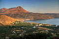
The terrain is mountainous and inaccessible.
Until recent years many Mani villages could be reached only by sea. Today a narrow and winding road extends along the west coast from Kalamata to Areopoli, then south to Akrotainaro (the pointed cape, which is the southernmost point of continental Greece) before it turns north toward Gytheio. Another road, that is used by the public buses of the Piraeus–Mani line, which has existed for several decades, comes from Tripoli through Sparta, Gytheio, Areopoli and ends in the Gerolimenas port near Cape Matapan. Mani has been traditionally divided into three regions:
- Exo Mani (Έξω Μάνη) or Outer Mani to the northwest,
- Kato Mani (Κάτω Μάνη) or Lower Mani to the east,
- Mesa Mani (Μέσα Μάνη) or Inner Mani to the southwest.
A fourth region named Vardounia (Βαρδούνια) to the north is also sometimes included but was never historically part of Mani. Vardounia served as a buffer between the Ottoman-Turkish controlled Evrotas plains and Mani. A contingent of Muslim Albanian settlers were relocated to the region by the Ottomans. These settlers formed a large segment of the local population until the Greek War of Independence when they fled to the Turkish stronghold at Tripoli.[2] Following the war Vardounia's Greek population was reinforced by settlers from Lower Mani and central Laconia.
Administratively, Mani is now divided between the prefectures of Laconia (Kato Mani, Mesa Mani) and Messenia (Exo Mani), in the periphery of Peloponnesos, but in ancient times it lay entirely within Laconia, the district dominated by Sparta. The Messenian Mani (also called aposkiaderi, a local expression meaning "shady") receives somewhat more rainfall than the Laconian (called prosiliaki, a local expression meaning "sunny"), and is consequently more productive in agriculture. Maniots from what is now Messenian Mani have surnames that uniformly end in -éas, whereas Maniots from what is now Laconian Mani have surnames that end in -ákos; additionally there is the -óggonas ending, a corruption of éggonos, "grandson".
History
.svg)


A skull of
As the power of the
After the
In 1460, after the
The first of these was
Following the failure of the
- Tzanetos Koutoufaris (1776–1779)
- Michalbey Troupakis, known as Mourtzinos (1779–1782)
- Tzanetos Kapetanakis Grigorakisor Tzanetbey (1782–1798)
- Panagiotis Koumoundouros (1798–1803)
- Antonbey Grigorakis (1803–1808)
- Konstantinos Zervakos or Zervobey (1808–1810)
- Theodorobey Tzanetakis (1811–1815)
- Petrobey Mavromichalis (1815–1821)
As Ottoman power declined, the mountains of the Mani became a stronghold of the
In 1878 the national government reduced the local autonomy of the Mani, and the area gradually became a backwater; inhabitants abandoned the land through emigration, with many going to major Greek cities, as well as to western Europe and the United States. It was not until the 1970s, when the construction of new roads supported the growth of the tourist industry, that the Mani began to regain population and become prosperous.
Economy
Despite the region's aridity, Mani is known for its unique culinary products such as glina or syglino (pork or pork sausage smoked with aromatic herbs such as thyme, oregano, mint, etc. and stored in lard along with orange peel). Mani is also known for honey and extra-virgin olive oil, soft-pressed from partially ripened olives of the Koroneiki variety, which are grown on mountain terraces.
Today the Mani's coastal villages are full of cafés and souvenir shops. The peninsula attracts visitors for its Byzantine churches, Frankish castles, sandy beaches and scenery. Some popular beaches during the summer are Kalogria and the beaches by
Gytheio, Areopoli, Kardamyli, and Stoupa are filled with tourists during the summer months, but the region is generally quiet during the winter. Many inhabitants work as olive farmers, and devote the winter months to the olive harvest and processing. Some of the villages in the mountains are less tourist oriented and often have very few inhabitants.
Religion
The introduction of Christianity came late in the Mani: the first Greek temples began to be converted into Christian churches during the 11th century A.D. A
St. Nikon was sent to the Mani in the latter half of the 10th century to preach Christianity to the Maniots. Although the Maniots began to convert to Christianity century due to Nikon's preaching, it took more than 200 years, i.e. until the 11th and 12th centuries to eliminate most of the pagan Greek religion and traditions and for the Maniots to fully accept Christianity. After his sanctification by the Greek Orthodox Church, St. Nikon became patron saint of the Mani as well as Sparta.
Patrick Leigh Fermor wrote of them:
Sealed off from outside influences by their mountains, the semi-
Kent.[5]
Gallery
-
 Tower houses in Skoutari
 -
 Oitylo village
 -
 Diros cave
 -
 Landscape
 -
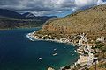 Limeni (port) of Areopoli
 -
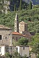 The Church of St. Spyridon in Kardamyli
 -
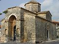 Byzantine Saints Theodoroi church in Kampos


See also
References
- ^ Patrick Leigh Fermor, Mani: Travels in the Southern Peloponnese, p. 94
- ^ "Mani - Kato Mani - from Kelefa to Vardounia and on to Githeon". www.zorbas.de.
- ISBN 978-1-78570-648-6.
- ^ a b Leigh Fermor, Patrick (1958). Mani: Travels in the Southern Peloponnese. John Murray. p. 48.
- ^ Leigh Fermor, Patrick (1958). Mani: Travels in the Southern Peloponnese. John Murray. p. 46.
Further reading
- ISBN 0-7195-6691-6.
- Mickey Demos, Life in Mani Today: The Road to Freedom. 2011
- Alta Ann Parkins, "Pictures of the Mani", Athens 1971.
External links
- . Encyclopædia Britannica (11th ed.). 1911.
36°33′32″N 22°25′49″E / 36.5590°N 22.4303°E
| International | |
|---|---|
| National | |