
Mansface Hill
| Mansface Hill | |
|---|---|
.jpg) Mansface Hill, the north face. | |
| Highest point | |
| Elevation | 6,690 ft (2,040 m) |
| Coordinates | 41°30′51.92″N 109°28′46.60″W / 41.5144222°N 109.4796111°W |
| Geography | |
| Location | Green River, Wyoming, U.S. |
| Climbing | |
| Easiest route | Access Road |
Mansface Hill is a mountain located in Green River, Wyoming. The mountain is named for its rock outcroppings, which form the shape of a face looking up into the sky.
Access
Mansface is accessible from Green River via two access roads. The first road begins at the top of an area known as South Hill on
Summit
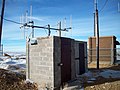
On the summit of the hill are various radio towers for both local business and government entities. A tower for the city of Green River 's
Christmas tree
Every year in either late November or early December, several local residents haul a Christmas tree to the summit. The tree is decorated and is lit at night. Power to the tree comes from the tower farm located nearby. In 2007, the tree was placed by members of the local business "The Radio Network", which owns radio stations KFRZ, KYCS, KUGR, and KZWB.[4]
-
 The east face with the Christmas tree, 2008
 -
 K232CU's tower, located at the heart of the tower farm
 -
 A close up of the Christmas tree, with deer below
 -
 Green River, looking east from Mansface


References
- ^ "ASR Registration 1228606". Retrieved 13 March 2017.
- ^ "K232CU-FM 94.3 MHz Radio Station Information". Retrieved 13 March 2017.
- ^ K232CU FCC Query
- ^ Green River City Council Meeting 2007 Archived 2012-07-31 at archive.today
See also
This article about a location in Wyoming is a stub. You can help Wikipedia by expanding it. |