
Maramureș
This article needs additional citations for verification. (March 2010) |


Maramureș (
Alternatively, the term Maramureș is also used for the Maramureș County of Romania, which contains the southern section of the historical region.
Name in other languages
Alternative names for Maramureș include
Geography
Maramureș is a valley enclosed by the Oaș, Gutâi, Țibleș and Rodnei mountains (the northern section of the
The limits of the region are between the parallels of 47°33' N and 47°02' N and the meridians of 23°15' E and 25°03' E. Maramureș represents one of the largest depressions in the Carpathians, covering an area of about 10,000 km2.
Its length from Khust to Prislop Pass is about 150 km and width from North to South is up to 80 km.
The main mountain passes linking Maramureș with the neighboring regions are high and in the past were hardly accessible in the winter. The Prislop Pass (1,416 m high) links the east of the region with Moldavia, Dealul Ștefăniței (1,254 m) links the south to Transylvania, the Pintea Pass (987 m) towards Baia Mare, Fărgău (587 m) in the west links the region to Oaș Country, while Frasini Pass (Yasinia; 931 m) links the north of the region to Galicia.
The mountains surrounding this region occupy more than half of the area. A few peaks reach above 2,000 m, such as Pietrosul (2,303 m) in the Rodnei Mountains to the south and Hovârla (2,061 m) in Muntele Negru (Cernahora) to the north.
The heavy forested mountains sustain many protected species of plants, such as
The last
Several protected areas have been created in Maramureș. The Rodna Mountains National Park was designated in 1990, the Maramureș Mountains Natural Park in 2004, and there are many other caves, gorges, cliff formations, and lakes which are officially-protected areas.
History


In ancient times, this area was settled by
The territory was part of the
In the 16th century, the Kingdom of Hungary was invaded and all but destroyed by the
After the
People
_-_IMG_11.jpg)
In the
In the northern area most people speak
Gallery
-
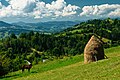 Haystacks Borșa Rodna Mountains National Park
 -
-
 Lala Mare Lake, Rodna Mountains
 -
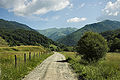
 Winter landscape
 -
 Baia Sprie
 -
 Fortress of Ardud
 -
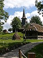
 Borșa
Borșa -
 Ethnographic Museum in Baia Mare
 -
 Ethnographic Museum of the Oaș Country
 -
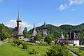 Bârsana Orthodox Monastery
 -
 Rohia Orthodox Monastery
 -
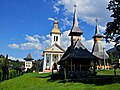 Moisei Monastery
 -
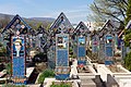 Merry Cemetery in Săpânța
 -
 Village Museum in Baia Mare
 -
 The Curtea Veche in Sighet
 -

-

-
 Bastion of Baia Mare
 -
 Degenfeld House in Baia Mare
 -
 Horses Waterfall
 -
 Quartz Rhodochrosite from Cavnic Mine
 -
 Fluorite Quartz from Boldut Mine
 -
 Mocăniță Railway
 -
 Iza River


.jpg)
.jpg)

.jpg)


.jpg)

.jpg)


_-_Baia_Mare.jpg)


See also
Further reading
- Atlas and Gazetteer of Historic Hungary 1914, Talma Kiadó ISBN 963-85683-4-8
- Sighetul Marmatiei, Culture and Tourism 2007, ISBN 973-7663-12-8
References
- ^ Hutsul coup. The Ukrainian Week. November 14, 2010
- ^ "Maramureș region". Internet Encyclopedia of Ukraine. Mykola Pavliuk, Arkadii Zhukovsky. Retrieved 11 February 2017.
External links
- Things to do when visiting Maramureș
- English translation of the Máramaros Yizkor Book Sefer Marmarosh; mea ve-shishim kehilot kedoshot be-yishuvan u-ve-hurbanan published in 1983 and 1996 (history and remembrance book of the approximately 160 Máramaros area Jewish shtetls and communities, and their destruction in the Holocaust)
| Banat |
|
|---|---|
| Dobruja |
|
| Moldavia |
|
| Transylvania | |
| Wallachia | |
| |