
Mare Orientale
Coordinates 19°24′S 92°48′W / 19.4°S 92.8°W | | |
| Diameter | 294 km (183 mi)[1] | |
|---|---|---|
| Eponym | Eastern Sea | |
Mare Orientale /ɔːriɛnˈteɪliː/ (Latin orientāle, the "eastern sea") is a lunar mare. It is located on the western border of the near side and far side of the Moon,[2] and is difficult to see from an Earthbound perspective. Images from spacecraft have revealed it to be one of the most striking large scale lunar features, resembling a target ring bullseye.
Geology
During the 1960s, rectified images of Mare Orientale by
The
Located at the antipode of Mare Orientale is Mare Marginis.
A
Discovery and name
Mare Orientale is difficult to observe from Earth, as it lies at the extreme western edge of the near side. All that can be seen are the rough mountain ranges—the Montes Rook and the Montes Cordillera—and some glimpses of the dark mare material beyond them.[12] However, the Moon's libration means that on rare occasions Mare Orientale is turned slightly more toward the Earth, and becomes a little more discernible.[13]
Although various astronomers had observed hints of the mare, it was first fully described by the German astronomer Julius Franz in his 1906 book Der Mond ("The Moon"). Franz also gave the mare its name, the "Eastern Sea", as it was located on what the convention at the time considered was the eastern side of the Moon as viewed from Earth,[14] though it is the western side as viewed by an astronaut walking on the Moon. In 1961, however, the International Astronomical Union adopted the astronautic convention for East and West on the Moon and this limb became the western edge.[13]
The first detailed study of the Mare Orientale was by Hugh Percy Wilkins, who called it "Lunar Mare X".[15] Franz's discoveries were not well known,[15] and in the 1976 edition of his book Guide to the Moon, Patrick Moore claims that he and Wilkins discovered and named Mare Orientale in 1946. However, Moore credits Franz as discoverer in his 2009 Yearbook of Astronomy (p. 133-135).
Gallery
-
 Topographic map
 -
 Gravity map based onGRAIL
 -
 Albedo mosaic of Clementine images
 -

-
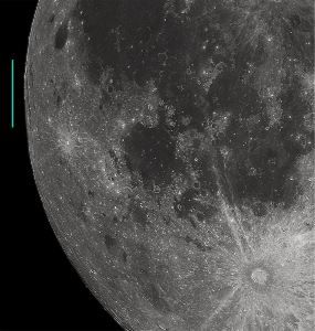 Photograph from Earth at full moon with Mare Orientale marked on the limb
 -
 Dome-shaped hills at the southern edge of Mare Orientale Basin, possibly formed by lava flows.
 -
 Apollo 17 photographed eastern Mare Orientale in the faint light of earthshine.


See also
References
- ^ "Mare Orientale". Gazetteer of Planetary Nomenclature. USGS Astrogeology Research Program.
- ^ Head 1991.
- ^ Beals & Tanner 1975, p. 299-306.
- ^ Hartmann & Kuiper 1962, pp. 51–66.
- ^ a b c d Kiefer, Walter S. "Lunar Orbiter: Impact Basin Geology". Lunar and Planetary Institute. Retrieved 29 October 2013.
- ^ Benningfield, Damond (17 June 2008). "Mare Orientale". StarDate.org. McDonald Observatory. Retrieved 29 October 2013.
- ^ Schwenzer, Susanne (3 November 2016). "Study sheds light on violent asteroid crash that caused mysterious 'crater rings' on the moon". The Conversation. Retrieved 3 November 2016.
- PMID 27789836.
- ^ "The Isabel Williamson Lunar Observing Program" (PDF). Royal Astronomical Society of Canada. March 2013. Archived from the original (PDF) on 5 July 2013. Retrieved 29 October 2013.
- USGS Professional Paper 1348. By Don E. Wilhelms, John F. McCauley, and Newell J. Trask. U.S. Government Printing Office, Washington: 1987. Chapter 10.
- S2CID 40110502.
- ^ Consolmagno & Davis 2011.
- ^ a b Baum & Whitaker 2007, p. 129.
- ^ Baum & Whitaker 2007, p. 132.
- ^ a b Baum & Whitaker 2007, p. 133.
Bibliography
- Beals, C. S.; Tanner, R. W. (December 1975). "On the Age of Mare Orientale". Journal of the Royal Astronomical Society of Canada. 69: 299–306. Bibcode:1975JRASC..69..299B.
- Baum, R.; Whitaker, E. A. (June 2007). "Mare Orientale: The Eastern Sea in the west - Discovery and nomenclature". Journal of the British Astronomical Association. 117 (3): 129–135. Bibcode:2007JBAA..117..129B.
- Consolmagno, G.; Davis, D. M. (2011). Turn Left at Orion (4th ed.). Cambridge University Press. p. 39. ISBN 9780521153973.
- Hartmann, W. K.; Kuiper, G. P. (1962). "Concentric Structures Surrounding Lunar Basins". Communications of the Lunar and Planetary Laboratory. 1 (1): 51–66. Bibcode:1962CoLPL...1...51H.
- Head, J.; et al. (1991). Orientale and South Pole-Aitken Basins on the Moon: Preliminary Galileo Imaging Results (PDF). 22nd Lunar and Planetary Science Conference. 18-22, 1991. Houston, Texas. pp. 23–26. Bibcode:1991LPICo.758...23H. NASA Accession No. N91-20002.
- Ulrich, G. E.; Saunders, R. S. (July 1968). "Advanced Systems Traverse Research Project Report" (PDF). Astrogeology (7). United States Geological Survey: 47–48. )
| Authority control databases: National |
|---|