Marine coastal ecosystem
| Marine habitats |
|---|
 |
| Coastal habitats |
| Ocean surface |
|
| Open ocean |
| Sea floor |
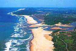
A marine coastal ecosystem is a marine ecosystem which occurs where the land meets the ocean. Marine coastal ecosystems include many very different types of marine habitats, each with their own characteristics and species composition. They are characterized by high levels of biodiversity and productivity.
For example,
Further examples are
Directly and indirectly, marine coastal ecosystems provide vast arrays of
These ecosystems are vulnerable to various anthropogenic and natural disturbances, such as
Overview
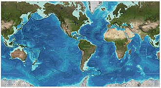
Coastal seas are highly productive systems, providing an array of ecosystem services to humankind, such as processing of nutrient effluents from land and climate regulation.
Coastal systems also contribute to the regulation of climate and nutrient cycles, by efficiently processing anthropogenic emissions from land before they reach the ocean.[2][3][4][5] The high value of these ecosystem services is obvious considering that a large proportion of the world population lives close to the coast.[6][7][1]
Currently, coastal seas around the world are undergoing major ecological changes driven by human-induced pressures, such as climate change, anthropogenic nutrient inputs, overfishing and the spread of invasive species.[8][9] In many cases, the changes alter underlying ecological functions to such an extent that new states are achieved and baselines are shifted.[10][11][1]
In 2015, the United Nations established 17
Coastal habitats
Intertidal zone

Intertidal zones are the areas that are visible and exposed to air during low tide and covered up by saltwater during high tide.[14] There are four physical divisions of the intertidal zone with each one having its distinct characteristics and wildlife. These divisions are the Spray zone, High intertidal zone, Middle Intertidal zone, and Low intertidal zone. The Spray zone is a damp area that is usually only reached by the ocean and submerged only under high tides or storms. The high intertidal zone is submerged at high tide but remains dry for long periods between high tides.[14] Due to the large variance of conditions possible in this region, it is inhabited by resilient wildlife that can withstand these changes such as barnacles, marine snails, mussels and hermit crabs.[14] Tides flow over the middle intertidal zone two times a day and this zone has a larger variety of wildlife.[14] The low intertidal zone is submerged nearly all the time except during the lowest tides and life is more abundant here due to the protection that the water gives.[14]
Estuaries
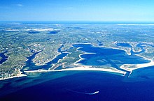
Estuaries occur where there is a noticeable change in salinity between saltwater and freshwater sources. This is typically found where rivers meet the ocean or sea. The wildlife found within estuaries is unique as the water in these areas is brackish - a mix of freshwater flowing to the ocean and salty seawater.[15] Other types of estuaries also exist and have similar characteristics as traditional brackish estuaries. The Great Lakes are a prime example. There, river water mixes with lake water and creates freshwater estuaries.[15] Estuaries are extremely productive ecosystems that many humans and animal species rely on for various activities.[16] This can be seen as, of the 32 largest cities in the world, 22 are located on estuaries as they provide many environmental and economic benefits such as crucial habitat for many species, and being economic hubs for many coastal communities.[16] Estuaries also provide essential ecosystem services such as water filtration, habitat protection, erosion control, gas regulation nutrient cycling, and it even gives education, recreation and tourism opportunities to people.[17]

Lagoons
Lagoons are areas that are separated from larger water by natural barriers such as coral reefs or sandbars. There are two types of lagoons, coastal and oceanic/atoll lagoons.[18] A coastal lagoon is, as the definition above, simply a body of water that is separated from the ocean by a barrier. An atoll lagoon is a circular coral reef or several coral islands that surround a lagoon. Atoll lagoons are often much deeper than coastal lagoons.[19] Most lagoons are very shallow meaning that they are greatly affected by changed in precipitation, evaporation and wind. This means that salinity and temperature are widely varied in lagoons and that they can have water that ranges from fresh to hypersaline.[19] Lagoons can be found in on coasts all over the world, on every continent except Antarctica and is an extremely diverse habitat being home to a wide array of species including birds, fish, crabs, plankton and more.[19] Lagoons are also important to the economy as they provide a wide array of ecosystem services in addition to being the home of so many different species. Some of these services include fisheries, nutrient cycling, flood protection, water filtration, and even human tradition.[19]
Reefs
Coral reefs
Coral reefs are one of the most well-known marine ecosystems in the world, with the largest being the Great Barrier Reef. These reefs are composed of large coral colonies of a variety of species living together. The corals from multiple symbiotic relationships with the organisms around them.[20] Coral reefs are being heavily affected by global warming. They are one of the most vulnerable marine ecosystems. Due to marine heatwaves that have high warming levels coral reefs are at risk of a great decline, loss of its important structures, and exposure to higher frequency of marine heatwaves.[21]
-
Coral reef
-
Global distribution of coral, mangrove, and seagrass diversity
Bivalve reefs
Bivalve reefs provide coastal protection through erosion control and shoreline stabilization, and modify the physical landscape by
Vegetated
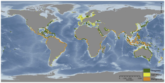
Vegetated coastal ecosystems occur throughout the world, as illustrated in the diagram on the right.
Rapid loss of vegetated coastal ecosystems through land-use change has occurred for centuries, and has accelerated in recent decades. Causes of habitat conversion vary globally and include conversion to aquaculture, agriculture, forest over-exploitation, industrial use, upstream dams, dredging, eutrophication of overlying waters, urban development, and conversion to open water due to accelerated sea-level rise and subsidence.[25][24]
Vegetated coastal ecosystems typically reside over organic-rich sediments that may be several meters deep and effectively lock up carbon due to low-oxygen conditions and other factors that inhibit decomposition at depth.[26] These carbon stocks can exceed those of terrestrial ecosystems, including forests, by several times.[27][28] When coastal habitats are degraded or converted to other land uses, the sediment carbon is destabilised or exposed to oxygen, and subsequent increased microbial activity releases large amounts of greenhouse gasses to the atmosphere or water column.[29][26][30][31][32][33] The potential economic impacts that come from releasing stored coastal blue carbon to the atmosphere are felt worldwide. Economic impacts of greenhouse gas emissions in general stem from associated increases in droughts, sea level, and frequency of extreme weather events.[34][24]
-
Conceptual diagram of estuarine vegetation
-
Ecosystem services provided by a vegetated coastal ecosystem.Penaeid prawn lifecycle indicating that valuations for harvest areas may overlook critical importance within the lifecycle.[35]
Coastal wetlands
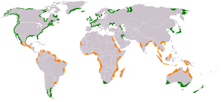
Coastal wetlands are among the most productive ecosystems on Earth and generate vital services that benefit human societies around the world. Sediment-stabilization by wetlands such as salt marshes and mangroves serves to protect coastal communities from storm-waves, flooding, and land erosion.[39] Coastal wetlands also reduce pollution from human waste,[40][41] remove excess nutrients from the water column,[42] trap pollutants,[43] and sequester carbon.[44] Further, near-shore wetlands act as both essential nursery habitats and feeding grounds for game fish, supporting a diverse group of economically important species.[45][46][47][48][49]
Mangrove forests
Mangroves are trees or shrubs that grow in low-oxygen soil near coastlines in tropical or subtropical latitudes.[50] They are an extremely productive and complex ecosystem that connects the land and sea. Mangroves consist of species that are not necessarily related to each other and are often grouped for the characteristics they share rather than genetic similarity.[51] Because of their proximity to the coast, they have all developed adaptions such as salt excretion and root aeration to live in salty, oxygen-depleted water.[51] Mangroves can often be recognized by their dense tangle of roots that act to protect the coast by reducing erosion from storm surges, currents, wave, and tides.[50] The mangrove ecosystem is also an important source of food for many species as well as excellent at sequestering carbon dioxide from the atmosphere with global mangrove carbon storage is estimated at 34 million metric tons per year.[51]
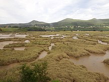
Salt marshes
Salt marshes are a transition from the ocean to the land, where fresh and saltwater mix.[52] The soil in these marshes is often made up of mud and a layer of organic material called peat. Peat is characterized as waterlogged and root-filled decomposing plant matter that often causes low oxygen levels (hypoxia). These hypoxic conditions causes growth of the bacteria that also gives salt marshes the sulfurous smell they are often known for.[53] Salt marshes exist around the world and are needed for healthy ecosystems and a healthy economy. They are extremely productive ecosystems and they provide essential services for more than 75 percent of fishery species and protect shorelines from erosion and flooding.[53] Salt marshes can be generally divided into the high marsh, low marsh, and the upland border. The low marsh is closer to the ocean, with it being flooded at nearly every tide except low tide.[52] The high marsh is located between the low marsh and the upland border and it usually only flooded when higher than usual tides are present.[52] The upland border is the freshwater edge of the marsh and is usually located at elevations slightly higher than the high marsh. This region is usually only flooded under extreme weather conditions and experiences much less waterlogged conditions and salt stress than other areas of the marsh.[52]
Seagrass meadows
Seagrasses evolved from marine algae which colonized land and became land plants, and then returned to the ocean about 100 million years ago. However, today seagrass meadows are being damaged by human activities such as pollution from land runoff, fishing boats that drag dredges or trawls across the meadows uprooting the grass, and overfishing which unbalances the ecosystem. Seagrass meadows are currently being destroyed at a rate of about two football fields every hour.
-
Seagrass meadow
-
Kelp forest
| External videos | |
|---|---|
Kelp forests
Kelp forests occur worldwide throughout
Physically formed by brown
However, the influence of humans has often contributed to kelp
Coastal ecology
Coastal food webs
| External videos | |
|---|---|
– David Attenborough, full episode, Netflix |
Coastal waters include the waters in
Ecosystems, even those with seemingly distinct borders, rarely function independently of other adjacent systems.[66] Ecologists are increasingly recognizing the important effects that cross-ecosystem transport of energy and nutrients have on plant and animal populations and communities.[67][68] A well known example of this is how seabirds concentrate marine-derived nutrients on breeding islands in the form of feces (guano) which contains ~15–20% nitrogen (N), as well as 10% phosphorus.[69][70][71] These nutrients dramatically alter terrestrial ecosystem functioning and dynamics and can support increased primary and secondary productivity.[72][73] However, although many studies have demonstrated nitrogen enrichment of terrestrial components due to guano deposition across various taxonomic groups,[72][74][75][76] only a few have studied its retroaction on marine ecosystems and most of these studies were restricted to temperate regions and high nutrient waters.[69][77][78][79] In the tropics, coral reefs can be found adjacent to islands with large populations of breeding seabirds, and could be potentially affected by local nutrient enrichment due to the transport of seabird-derived nutrients in surrounding waters. Studies on the influence of guano on tropical marine ecosystems suggest nitrogen from guano enriches seawater and reef primary producers.[77][80][81]
Reef building corals have essential nitrogen needs and, thriving in nutrient-poor tropical waters[82] where nitrogen is a major limiting nutrient for primary productivity,[83] they have developed specific adaptations for conserving this element. Their establishment and maintenance are partly due to their symbiosis with unicellular dinoflagellates, Symbiodinium spp. (zooxanthellae), that can take up and retain dissolved inorganic nitrogen (ammonium and nitrate) from the surrounding waters.[84][85][86] These zooxanthellae can also recycle the animal wastes and subsequently transfer them back to the coral host as amino acids,[87] ammonium or urea.[88] Corals are also able to ingest nitrogen-rich sediment particles[89][90] and plankton.[91][92] Coastal eutrophication and excess nutrient supply can have strong impacts on corals, leading to a decrease in skeletal growth,[85][93][94][95][81]
-
Pathways for guano-derived nitrogen to enter marine food webs[81]
-
Seabird colonies are nutrient hot spots, especially, for nitrogen and phosphorus[65]
Coastal predators
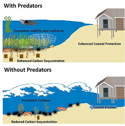
Food web theory predicts that current global declines in marine predators could generate unwanted consequences for many marine ecosystems. In coastal plant communities, such as kelp, seagrass meadows, mangrove forests and salt marshes, several studies have documented the far-reaching effects of changing predator populations. Across coastal ecosystems, the loss of marine predators appears to negatively affect coastal plant communities and the ecosystem services they provide.[96]
The green world hypothesis predicts loss of predator control on herbivores could result in runaway consumption that would eventually denude a landscape or seascape of vegetation.[97] Since the inception of the green world hypothesis, ecologists have tried to understand the prevalence of indirect and alternating effects of predators on lower trophic levels (trophic cascades), and their overall impact on ecosystems.[98] Multiple lines of evidence now suggest that top predators are key to the persistence of some ecosystems.[98][96]
With an estimated habitat loss greater than 50 percent, coastal plant communities are among the world’s most endangered ecosystems.
There is little doubt that collapsing marine predator populations results from
Understanding the importance of predators in coastal plant communities has been bolstered by their documented ability to influence ecosystem services. Multiple examples have shown that changes to the strength or direction of predator effects on lower trophic levels can influence
Seascape ecology

Seascape ecology is the marine and coastal version of landscape ecology.[117] It is currently emerging as an interdisciplinary and spatially explicit ecological science with relevance to marine management, biodiversity conservation, and restoration.[116] Seascapes are complex ocean spaces, shaped by dynamic and interconnected patterns and processes operating across a range of spatial and temporal scales.[118][119][120] Rapid advances in geospatial technologies and the proliferation of sensors, both above and below the ocean surface, have revealed intricate and scientifically intriguing ecological patterns and processes,[121][122][123] some of which are the result of human activities.[124][125] Despite progress in the collecting, mapping, and sharing of ocean data, the gap between technological advances and the ability to generate ecological insights for marine management and conservation practice remains substantial.[126][127] For instance, fundamental gaps exist in the understanding of multidimensional spatial structure in the sea,[123][120][128] and the implications for planetary health and human wellbeing.[127] Deeper understanding of the multi-scale linkages between ecological structure, function, and change will better support the design of whole-system strategies for biodiversity preservation and reduce uncertainty around the consequences of human activity. For example, in the design and evaluation of marine protected areas (MPAs) and habitat restoration, it is important to understand the influence of spatial context, configuration, and connectivity, and to consider effects of scale.[129][130][131][132][116]
-
Fish migrations between coral reef, macroalgae, seagrass and mangrove habitats:ontogeneticmigration of juvenile coral reef fish.
-
The ecosystem cascade to structure the stock-taking and scenario analysis steps in the marine spatial planning process.[134]
Interactions between ecosystems
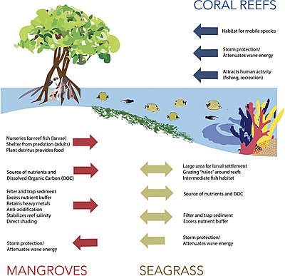
The diagram on the right shows the principal interactions between mangroves, seagrass, and coral reefs.[135] Coral reefs, seagrasses, and mangroves buffer habitats further inland from storms and wave damage as well as participate in a tri-system exchange of mobile fish and invertebrates. Mangroves and seagrasses are critical in regulating sediment, freshwater, and nutrient flows to coral reefs.[135]
The diagram immediately below shows locations where mangroves, coral reefs, and seagrass beds exist within one km of each other. Buffered intersection between the three systems provides relative co-occurrence rates on a global scale. Regions where systems strongly intersect include Central America (Belize), the Caribbean, the Red Sea, the Coral Triangle (particularly Malaysia), Madagascar, and the Great Barrier Reef.[135]
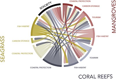
The diagram at the right graphically illustrates the ecosystem service synergies between mangroves, seagrasses, and coral reefs. The ecosystem services provided by intact reefs, seagrasses, and mangroves are both highly valuable and mutually enhance each other. Coastal protection (storm/wave attenuation) maintains the structure of adjacent ecosystems, and associated ecosystem services, in an offshore-to-onshore direction. Fisheries are characterized by migratory species, and therefore, protecting fisheries in one ecosystem increases fish biomass in others. Tourism benefits from coastal protection and healthy fisheries from multiple ecosystems. Here, we do not draw within-ecosystem connections in order to better emphasise synergies between systems.[135]
Network ecology
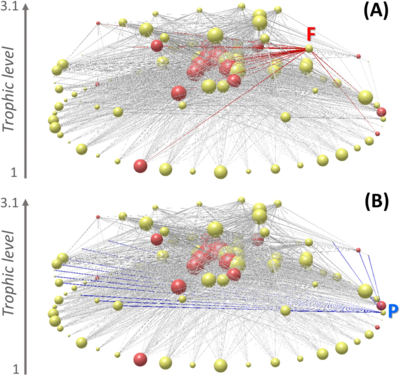
To compound things, removal of biomass from the ocean occurs simultaneously with multiple other stressors associated to climate change that compromise the capacity of these socio-ecological systems to respond to perturbations.
Coastal biogeochemistry
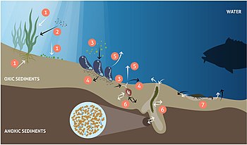
Globally,
Efforts to mitigate eutrophication through nutrient load reductions are hampered by the effects of climate change.[9] Changes in precipitation increase the runoff of N, P and carbon (C) from land, which together with warming and increased CO2 dissolution alter the coupled marine nutrient and carbon cycles.[170][171][1]
In contrast to the
Changes in
Artisan fisheries
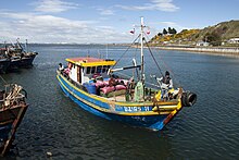
Direct human impacts and the full suite of drivers of global change are the main cause of species extinctions in Anthropocene ecosystems,[190][105] with detrimental consequences on ecosystem functioning and their services to human societies.[191][192] The world fisheries crisis is among those consequences, which cuts across fishing strategies, oceanic regions, species, and includes countries that have little regulation and those that have implemented rights-based co-management strategies to reduce overharvesting.[193][194][195][196][136]
Chile has been one of the countries implementing Territorial Use Rights (TURFs)[197][198] over an unprecedented geographic scale to manage the diverse coastal benthic resources using a co-management strategy.[199][200] These TURFS are used for artisanal fisheries. Over 60 coastal benthic species are actively harvested by these artisanal fisheries,[201] with species that are extracted from intertidal and shallow subtidal habitats.[202][203] The Chilean TURFs system brought significant improvements in sustainability of this complex socio-ecological system, helping to rebuild benthic fish stocks,[201][199] improving fishers’ perception towards sustainability and increasing compliance9, as well as showing positive ancillary effects on conservation of biodiversity.[204][205] However, the situation of most artisanal fisheries is still far from sustainable, and many fish stocks and coastal ecosystems show signs of overexploitation and ecosystem degradation, a consequence of the low levels of cooperation and low enforcement of TURF regulations, which leads to high levels of free-riding and illegal fishing.[206][207][208] It is imperative to improve understanding of the effects of these multi-species artisanal fisheries which simultaneously harvest species at all trophic levels from kelp primary producers to top carnivores.[203][209][136]
Remote sensing
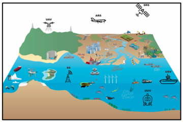
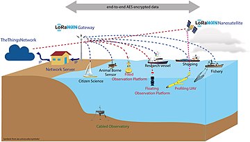
Coastal zones are among the most populated areas on the planet.[212][213] As the population continues to increase, economic development must expand to support human welfare. However, this development may damage the ability of the coastal environment to continue supporting human welfare for current and future generations.[214] The management of complex coastal and marine social-ecological systems requires tools that provide frameworks with the capability of responding to current and emergent issues.[215][210] Remote data collection technologies include satellite-based remote sensing, aerial remote sensing, unmanned aerial vehicles, unmanned surface vehicles, unmanned underwater vehicles, and static sensors.[210]
Frameworks have been developed that attempt to address and integrate these complex issues, such as the Millennium Ecosystem Assessment framework which links drivers, ecosystem services, and human welfare[216][210] However, obtaining the environmental data that is necessary to use such frameworks is difficult, especially in countries where access to reliable data and their dissemination are limited or non-existent[217] and even thwarted.[210] Traditional techniques of point sampling and observation in the environment do deliver high information content,[218] but they are expensive and often do not provide adequate spatial and temporal coverage, while remote sensing can provide cost-effective solutions, as well as data for locations where there is no or only limited information.[219][210]
Coastal observing systems are typically nationally funded and built around national priorities. As a result, there are presently significant differences between countries in terms of sustainability, observing capacity and technologies, as well as methods and research priorities.
Coastal areas are the most dynamic and productive parts of the oceans, which makes them a significant source of human resources and services. Coastal waters are located immediately in contact with human populations and exposed to anthropogenic disturbances, placing these resources and services under threat.[221] These concerns explain why, in several coastal regions, a rapidly increasing number of observing systems have been implemented in the last decade.[222] Expansion of coherent and sustained coastal observations has been fragmented and driven by national and regional policies and is often undertaken through short-term research projects.[223] This results in significant differences between countries both in terms of sustainability and observing technologies, methods and research priorities.[211]
Unlike the open ocean, where challenges are rather well-defined and stakeholders are fewer and well-identified, coastal processes are complex, acting on several spatial and temporal scales, with numerous and diversified users and stakeholders, often with conflicting interests. To adapt to such complexity coastal ocean observing system must be an integrated, multidisciplinary and multiscale system of systems.[224][211]
Regime shifts
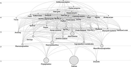
Marine ecosystems are affected by diverse pressures and consequently may undergo significant changes that can be interpreted as regime shifts.[225] Marine ecosystems worldwide are affected by increasing natural and anthropogenic pressures and consequently undergo significant changes at unprecedented rates. Affected by these changes, ecosystems can reorganise and still maintain the same function, structure, and identity.[226] However, under some circumstances, the ecosystem may undergo changes that modify the system’s structure and function and this process can be described as a shift to a new regime.[226][227][228][225]
Usually, a regime shift is triggered by large-scale climate-induced variations,[229] intense fishing exploitation[230] or both.[231] Criteria used to define regime shifts vary and the changes that have to occur in order to consider that a system has undergone a regime shift are not well-defined.[232] Normally, regime shifts are defined as high amplitude, low-frequency and often abrupt changes in species abundance and community composition that are observed at multiple trophic levels (TLs).[233] These changes are expected to occur on a large spatial scale and take place concurrently with physical changes in the climate system.[233][228][234][235][236][237][232][225]
Regime shifts have been described in several marine ecosystems including Northern
There is evidence, that changes in the intensity of the Iberian coastal upwelling (resulting from the strengthening or weakening northern winds) had occurred in the last decades. However, the character of these changes is contradictory where some authors observed intensification of upwelling-favourable winds[252][253] while others documented their weakening.[254][255] A 2019 review of upwelling rate and intensity along the Portuguese coast documented a successive weakening of the upwelling since 1950 that lasted till mid/late 1970s in the north-west and south-west and till 1994 in the south coast.[256] An increase in upwelling index over the period 1985–2009 was documented in all studied regions while additionally upwelling intensification were observed in the south.[256] A continuous increase in water temperature, ranging from 0.1 to 0.2 °C per decade has also been documented.[257][225]
Threats and decline
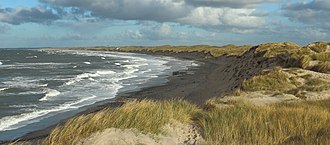
Many marine fauna utilise coastal habitats as critical nursery areas, for shelter and feeding, yet these habitats are increasingly at risk from agriculture, aquaculture, industry and urban expansion.[258] Indeed, these systems are subject to what may be called "a triple whammy" of increasing industrialisation and urbanisation, an increased loss of biological and physical resources (fish, water, energy, space), and a decreased resilience to the consequences of a warming climate and sea level rise.[259] This has given rise to the complete loss, modification or disconnection of natural coastal ecosystems globally. For example, almost 10% of the entire Great Barrier Reef coastline in Australia (2,300 km) has been replaced with urban infrastructure (e.g., rock seawalls, jetties, marinas), causing massive loss and fragmentation of sensitive coastal ecosystems.[260] Global loss of seagrass reached around 7% of seagrasses area per year by the end of the twentieth century.[261] A global analysis of tidal wetlands (mangroves, tidal flats, and tidal marshes) published in 2022 estimated global losses of 13,700 km2 (5,300 sq mi) from 1999-2019, however, this study also estimated that these losses were largely offset by the establishment of 9,700 km2 (3,700 sq mi) of new tidal wetlands that were not present in 1999.[262] Approximately three-quarters of the 4,000 km2 (1,500 sq mi) net decrease between 1999 and 2019 occurred in Asia (74.1%), with 68.6% concentrated in three countries: Indonesia (36%), China (20.6%), and Myanmar (12%).[262] Of these global tidal wetland losses and gains, 39% of losses and 14% of gains were attributed to direct human activities.[262]
Approximately 40% of the global mangrove has been lost since the 1950's[263] with more than 9,736 km2 of the world's mangroves continuing to be degraded in the 20 years period between 1996 and 2016.[264] Saltmarshes are drained when coastal land is claimed for agriculture, and deforestation is an increasing threat to shoreline vegetation (such as mangroves) when coastal land is appropriated for urban and industrial development,[263] both of which may result in the degradation of blue carbon storages and increasing greenhouse gas emissions.[265]
These accumulating pressures and impacts on coastal ecosystems are neither isolated nor independent, rather they are synergistic, with feedbacks and interactions that cause individual effects to be greater than their sums.[266] In the year before the ecosystem restoration Decade commences, there is a critical knowledge deficit inhibiting an appreciation of the complexity of coastal ecosystems that hampers the development of responses to mitigate continuing impacts—not to mention uncertainty on projected losses of coastal systems for some of the worst-case future climate change scenarios.[267]
Restoration
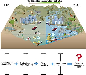
The United Nations has declared 2021–2030 the UN Decade on Ecosystem Restoration. This call to action has the purpose of recognising the need to massively accelerate global restoration of degraded ecosystems, to fight the climate heating crisis, enhance food security, provide clean water and protect biodiversity on the planet. The scale of restoration will be key. For example, the Bonn Challenge has the goal to restore 350 million km2, about the size of India, of degraded terrestrial ecosystems by 2030. However, international support for restoration of blue coastal ecosystems, which provide an impressive array of benefits to people, has lagged.
The diagram on the right shows the current state of modified and impacted coastal ecosystems and the expected state following the decade of restoration.[267] Also, shown is the uncertainty in the success of past restoration efforts, current state of altered systems, climate variability, and restoration actions that are available now or on the horizon. This could mean that delivering the Decade on Ecosystem Restoration for coastal systems needs to be viewed as a means of getting things going where the benefits might take longer than a decade.[267]
Only the Global Mangrove Alliance[268] comes close to the Bonn Challenge, with the aim of increasing the global area of mangroves by 20% by 2030.[267] However, mangrove scientists have reservations about this target, voicing concerns that it is unrealistic and may prompt inappropriate practices in attempting to reach this target.[269][267]
Conservation and connectivity
There has recently been a perceptual shift away from habitat representation as the sole or primary focus of conservation prioritisation, towards consideration of ecological processes that shape the distribution and abundance of biodiversity features.[270][271][272][273] In marine ecosystems, connectivity processes are paramount,[274] and designing systems of marine protected areas that maintain connectivity between habitat patches has long been considered an objective of conservation planning.[270][275] Two forms of connectivity are critical to structuring coral reef fish populations:[276] dispersal of larvae in the pelagic environment,[277] and post-settlement migration by individuals across the seascape.[278] Whilst a growing literature has described approaches for considering larval connectivity in conservation prioritisation,[279][280][281] relatively less attention has been directed towards developing and applying methods for considering post-settlement connectivity[274][282][283]
Seascape connectivity (connectedness among different habitats in a seascape, c.f. among patches of the same habitat type
There is clear empirical evidence that proximity to nursery habitats can enhance the effectiveness (i.e. increasing the abundance, density, or biomass of fish species) of marine protected areas on coral reefs.[131][290][291][292][293] For example, at study sites across the western Pacific, the abundance of harvested fish species was significantly greater on protected reefs close to mangroves, but not on protected reefs isolated from mangroves.[292] The functional role of herbivorous fish species that perform ontogenetic migrations may also enhance the resilience of coral reefs close to mangroves.[294][295] Despite this evidence, and widespread calls to account for connectivity among habitats in the design of spatial management,[285][292][293] there remain few examples where seascape connectivity is explicitly considered in spatial conservation prioritisation (the analytical process of identifying priority areas for conservation or management actions).[283]
See also
References
- ^ doi:10.3389/fmars.2020.00450..
 Material was copied from this source, which is available under a Creative Commons Attribution 4.0 International License
 - .
- S2CID 130818402.
- S2CID 53418968.
- .
- S2CID 672256.
- S2CID 15215236.
- S2CID 26206024.
- ^ S2CID 35848588.
- ^ S2CID 12703389.
- .
- ^ United Nations (2017) Resolution adopted by the General Assembly on 6 July 2017, Work of the Statistical Commission pertaining to the 2030 Agenda for Sustainable Development (A/RES/71/313)
- ISSN 2296-7745.
- ^ a b c d e US Department of Commerce, National Oceanic and Atmospheric Administration. "What is the intertidal zone?". oceanservice.noaa.gov. Retrieved 2019-03-21.
- ^ a b US Department of Commerce, National Oceanic and Atmospheric Administration. "What is an estuary?". oceanservice.noaa.gov. Retrieved 2019-03-22.
- ^ a b US Department of Commerce, National Oceanic and Atmospheric Administration. "Estuaries, NOS Education Offering". oceanservice.noaa.gov. Retrieved 2019-03-22.
- ^ "Estuaries". www.crd.bc.ca. 2013-11-14. Retrieved 2019-03-24.
- ^ US Department of Commerce, National Oceanic and Atmospheric Administration. "What is a lagoon?". oceanservice.noaa.gov. Retrieved 2019-03-24.
- ^ a b c d Miththapala, Sriyanie (2013). "Lagoons and Estuaries" (PDF). IUCN, International Union for Conservation of Nature. Archived from the original (PDF) on 2016-11-23. Retrieved 2021-10-31.
- ^ "Corals and Coral Reefs". Ocean Portal | Smithsonian. 2012-09-12. Retrieved 2018-03-27.
- ^ IPCC. Chapter 3: Oceans and Coastal Ecosystems and their Services. IPCC Sixth Assessment Report. 1 October 2021. https://report.ipcc.ch/ar6wg2/pdf/IPCC_AR6_WGII_FinalDraft_Chapter03.pdf.
- OCLC 34319364.
- ^ PMID 22962585..
 Material was copied from this source, which is available under a Creative Commons Attribution 0.0 International License
 - ^ PMID 22962585.
- ^ .
- doi:10.1038/ngeo1123.
- PMID 22325586.
- .
- .
- .
- S2CID 18477012.
- .
- PMID 21738628.
- ^ ISSN 2296-7745..
 Material was copied from this source, which is available under a Creative Commons Attribution 4.0 International License
 - .
- S2CID 133926655.
- PMID 24379379.
- S2CID 17867808.
- )
- PMID 18342338.
- PMID 26706768.
- PMID 34872228.
- doi:10.1890/110004.
- .
- ^ .
- PMID 18645185.
- .
- doi:10.3389/fevo.2019.00131..
 Material was copied from this source, which is available under a Creative Commons Attribution 4.0 International License
 - ^ a b US Department of Commerce, National Oceanic and Atmospheric Administration. "What is a mangrove forest?". oceanservice.noaa.gov. Retrieved 2019-03-21.
- ^ a b c "Mangroves". Smithsonian Ocean. 30 April 2018. Retrieved 2019-03-21.
- ^ a b c d "What is a Salt Marsh?" (PDF). New Hampshire Department of Environmental Services. 2004. Archived from the original (PDF) on 2020-10-21. Retrieved 2021-10-31.
- ^ a b US Department of Commerce, National Oceanic and Atmospheric Administration. "What is a salt marsh?". oceanservice.noaa.gov. Retrieved 2019-03-20.
- ^ Mann, K.H. 1973. Seaweeds: their productivity and strategy for growth. Science 182: 975-981.
- ^ Graham, M.H., B.P. Kinlan, L.D. Druehl, L.E. Garske, and S. Banks. 2007. Deep-water kelp refugia as potential hotspots of tropical marine diversity and productivity. Proceedings of the National Academy of Sciences 104: 16576-16580.
- ^ Christie, H., Jørgensen, N.M., Norderhaug, K.M., Waage-Nielsen, E., 2003. Species distribution and habitat exploitation of fauna associated with kelp (Laminaria hyperborea) along the Norwegian coast. Journal of the Marine Biological Association of the UK 83, 687-699.
- ^ Jackson, G.A. and C.D. Winant. 1983. Effect of a kelp forest on coastal currents. Continental Shelf Report 2: 75-80.
- J.M. Erlandson, J.A. Estesand M.J. Tegner. 2002. Kelp forest ecosystems: biodiversity, stability, resilience and future. Environmental Conservation 29: 436-459.
- ^ Sala, E., C.F. Bourdouresque and M. Harmelin-Vivien. 1998. Fishing, trophic cascades, and the structure of algal assemblages: evaluation of an old but untested paradigm. Oikos 82: 425-439.
- ^ Dayton, P.K. 1985a. Ecology of kelp communities. Annual Review of Ecology and Systematics 16: 215-245.
- ^ Norderhaug, K.M., Christie, H., 2009. Sea urchin grazing and kelp re-vegetation in the NE Atlantic. Marine Biology Research 5, 515-528
- ^ Morton, Adam; Cordell, Marni; Fanner, David; Ball, Andy; Evershed, Nick. "The dead sea: Tasmania's underwater forests disappearing in our lifetime". the Guardian. Retrieved 2020-10-22.
- ^ Steinbauer, James. "What Will It Take to Bring Back the Kelp Forest? - Bay Nature Magazine". Bay Nature. Retrieved 2020-10-22.
- .
- ^ doi:10.1038/s41467-017-02446-8. Material was copied from this source, which is available under a Creative Commons Attribution 4.0 International License.
- .
- S2CID 84701185.
- ISSN 0006-3568.
- ^ PMID 23593452.
- .
- PMID 18837063.
- ^ PMID 22723945.
- ISBN 9780199735693.
- S2CID 6021420.
- S2CID 12110520.
- PMID 26504209.
- ^ S2CID 87850538.
- .
- S2CID 83734364.
- .
- ^ S2CID 6539261..
 Material was copied from this source, which is available under a Creative Commons Attribution 4.0 International License
 - ISBN 9781351092777.
- PMID 21232343.
- JSTOR 1312147.
- ^ S2CID 85085823.
- ^ Muscatine, L. (1990) "The role of symbiotic algae in carbon and energy flux in reef corals", Ecosystem World, 25: 75–87.
- S2CID 25973061.
- PMID 21676806.
- S2CID 13212636.
- S2CID 84698653.
- .
- S2CID 44869188.
- S2CID 83654833.
- .
- .
- ^ PMID 30233626..
 Material was copied from this source, which is available under a Creative Commons Attribution 4.0 International License
 - S2CID 84548124.
- ^ S2CID 7752940.
- .
- PMID 19587236.
- .
- PMID 26058068.
- PMID 11344287.
- S2CID 1459898.
- ^ S2CID 2500224.
- PMID 19251340.
- S2CID 35892592.
- .
- S2CID 22332630.
- hdl:10261/102715.
- PMID 24675669.
- doi:10.1890/110176.
- ^ .
- S2CID 15168162.
- ISBN 9789280730654.
- ^ S2CID 233453217..
 Material was copied from this source, which is available under a Creative Commons Attribution 4.0 International License
 - OCLC 993642256.
- ISBN 978-1-4899-2197-0.
- JSTOR 1941447.
- ^ OCLC 993642256.
- .
- S2CID 27798897.
- ^ hdl:1834/30670.
- hdl:10026.1/9695.
- PMID 31406130.
- hdl:10400.1/14027.
- ^ S2CID 211352061.
- PMID 32075534.
- S2CID 85630092.
- PMID 20808833.
- ^ .
- S2CID 219767109.
- doi:10.3389/fmars.2019.00130..
 Material was copied from this source, which is available under a Creative Commons Attribution 4.0 International License
 - S2CID 212792922..
 Material was copied from this source, which is available under a Creative Commons Attribution 4.0 International License
 - ^ S2CID 236255580..
 Material was copied from this source, which is available under a Creative Commons Attribution 4.0 International License
 - ^ PMID 33469119..
 Material was copied from this source, which is available under a Creative Commons Attribution 4.0 International License
 - S2CID 16838841.
- S2CID 206526700.
- PMID 23007078.
- PMID 22457967.
- ^ S2CID 52930402.
- S2CID 32516158.
- S2CID 85126141.
- ^ Thiel, M., Castilla, J.C., Fernández, M. and Navarrete, S., (2007). "The Humboldt current system of northern and central Chile". Oceanography and Marine Biology: An Annual Review, 45: 195-344
- .
- hdl:10261/73010.
- ^ PMID 23007086.
- .
- .
- S2CID 12403222.
- S2CID 224872806.
- .
- OCLC 727944896.
- ^ S2CID 2114852.
- ^ .
- ^ PMID 22313043.
- ^ .
- ^ PMID 19730676.
- hdl:11336/7024.
- S2CID 84592425.
- PMID 20482578.
- S2CID 4351240.
- S2CID 146077530.
- S2CID 4319289.
- PMID 33148659.
- S2CID 54722438.
- PMID 22926877.
- S2CID 55439201.
- PMID 23341613.
- PMID 11030643.
- S2CID 4318396.
- PMID 22119025.
- .
- S2CID 83974188.
- S2CID 32818786.
- S2CID 206657115.
- S2CID 13874905.
- ^ Cederwall, H. and Elmgren, R. (1980) "Biomass increase of benthic macrofauna demonstrates eutrophication of the Baltic Sea". In: Symposium of the Baltic Marine Biologists: relationship and exchange between the pelagic and benthic biota.
- ^ Pearson, T. H., and Rosenberg, R. (1987). “Feast and famine: Structuring factors in marine benthic communities”, in Organization Of Communities:The 27th Symposium of the British Ecological Society, Aberystwyth 1986, Eds: P. S. Giller and J. H. R. Gee (Oxford: Blackwell), 373–395.
- ^ .
- .
- ^ Newell R.I. (2004) "Ecosystem influences of natural and cultivated populations of suspension-feeding bivalve molluscs: a review". Journal of Shellfish Research, 23(1): 51–62.
- ISBN 9780120139293.
- S2CID 155821874.
- .
- PMID 24358713.
- .
- .
- S2CID 129291436.
- S2CID 4424650.
- S2CID 205006508.
- PMID 16895442.
- S2CID 2805799.
- S2CID 6912211.
- PMID 26784963.
- .
- ^ Sustainable fisheries: Territorial Use Rights for Fishing (TURF) Programs Fishery Solutions Center, Environmental Defense Fund. Retrieved: 2 November 2021.
- ^ Christy, F.T. (1982) "Territorial use rights in marine fisheries: definitions and conditions", Food and Agriculture Organisation, Fishing Technical Paper 227. United Nations, Rome.
- ^ PMID 20837530.
- .
- ^ ISBN 9780470996072.
- PMID 26236914.
- ^ .
- .
- S2CID 12693228.
- S2CID 3703022.
- PMID 32719385.
- PMID 28666013.
- PMID 10370266.
- ^ hdl:10400.1/14723..
 Material was copied from this source, which is available under a Creative Commons Attribution 4.0 International License
 - ^ ISSN 2296-7745..
 Material was copied from this source, which is available under a Creative Commons Attribution 4.0 International License
 - ^ Small, Christopher and Nicholls, Robert J. (2003) "A global analysis of human settlement in coastal zones". Journal of Coastal Research, 19(3): 584-599
- ^ Balk, D., Montgomery, M.R., McGranahan, G., Kim, D., Mara, V., Todd, M., Buettner, T. and Dorélien, A. (2009) "Mapping urban settlements and the risks of climate change in Africa, Asia and South America". Population dynamics and climate change, 80: 103.
- PMID 25104138.
- hdl:10400.1/13958.
- OCLC 560102324.
- S2CID 55168956.
- PMID 28118970.
- S2CID 140161355.
- .
- PMID 25517905.
- ISSN 2296-7745.
- ISSN 2296-7745.
- ^ GOOS (2012). "Requirements for Global Implementation of the Strategic Plan for Coastal GOOS". Rep. Glob. Ocean Observ. Syst., 193: 200. Intergovernmental Oceanographic Commission, UNESCO.
- ^ ISSN 2296-7745..
 Material was copied from this source, which is available under a Creative Commons Attribution 4.0 International License
 - ^ hdl:10535/3282.
- S2CID 4283750.
- ^ S2CID 8001853.
- .
- .
- PMC 3597262.
- ^ .
- ^ .
- ^ .
- .
- .
- .
- ^ .
- .
- PMID 24116045.
- .
- ^ Wooster, W. S., Bakun, A., and McLain, R. M. (1976). "Seasonal upwelling cycle along the Eastern boundary of the North Atlantic". J. Mar. Res., 34: 131–141.
- ^ Fiúza, A. F. D., de Macedo, M. E., and Guerreiro, M. R. (1982). "Climatological space and time variation of the Portuguese coastal upwelling". Oceanol. Acta, 5: 31–40.
- ^ ICES (2008). ICES IBTSWG REPORT 2012, Report of the International Bottom Trawl Survey Working Group (IBTSWG). Lisbon: ICES, 27–30.
- ^ ICES (2017). Report of the Working Group on Southern Horse Mackerel, Anchovy and Sardine (WGHANSA), 24–29 June 2017. Bilbao: ICES.
- .
- S2CID 86970659.
- .
- hdl:10400.1/8855.
- .
- S2CID 92274693.
- S2CID 140670266.
- S2CID 131408682.
- hdl:10261/80552.
- S2CID 206555669.
- ^ hdl:10400.1/12712.
- S2CID 134746927.
- PMID 21876770.
- .
- .
- PMID 19587236.
- ^ S2CID 248749118.
- ^ S2CID 4848686.
- PMID 28594908.
- hdl:10072/346256.
- S2CID 86131712.
- ^ hdl:2440/123896..
 Material was copied from this source, which is available under a Creative Commons Attribution 4.0 International License
 - ^ The Global Mangrove Alliance Home page.
- S2CID 139106235.
- ^ .
- .
- PMID 21311757.
- PMID 17981360.
- ^ PMID 28753647.
- S2CID 26332636.
- PMID 27859092.
- PMID 21141044.
- OCLC 489216282.
- PMID 27168206.
- S2CID 53605848.
- .
- .
- ^ PMID 28753647..
 Material was copied from this source, which is available under a Creative Commons Attribution 4.0 International License
 - S2CID 55137201.
- ^ .
- ISBN 9781316105412.
- S2CID 86729880.
- hdl:10072/60422.
- S2CID 11931956.
- hdl:10072/124967.
- S2CID 3958145.
- ^ hdl:10072/55829.
- ^ PMID 22675474.
- .
- PMID 17927771.
Further reading
- Horn, Michael (1999). Intertidal fishes : life in two worlds. San Diego: Academic Press. OCLC 237380300.


![A shy but threatened dugong grazes a seagrass meadow, encouraging regrowth[22]](http://upload.wikimedia.org/wikipedia/commons/thumb/9/91/Dugong_Marsa_Alam.jpg/400px-Dugong_Marsa_Alam.jpg)

![Ecosystem services provided by a vegetated coastal ecosystem.[35] Diagram showing connectivity between a vegetated coastal ecosystem for the Penaeid prawn lifecycle indicating that valuations for harvest areas may overlook critical importance within the lifecycle.[35]](http://upload.wikimedia.org/wikipedia/commons/thumb/f/f1/Ecosystem_services_provided_by_a_vegetated_coastal_ecosystem.jpg/668px-Ecosystem_services_provided_by_a_vegetated_coastal_ecosystem.jpg)



![Pathways for guano-derived nitrogen to enter marine food webs[81]](http://upload.wikimedia.org/wikipedia/commons/thumb/1/12/Pathways_for_guano-derived_nitrogen_to_enter_marine_food_webs.webp/528px-Pathways_for_guano-derived_nitrogen_to_enter_marine_food_webs.webp.png)
![Seabird colonies are nutrient hot spots, especially, for nitrogen and phosphorus[65]](http://upload.wikimedia.org/wikipedia/commons/thumb/6/64/Seabird_ornitheutrophication_coupling.png/565px-Seabird_ornitheutrophication_coupling.png)
![Fish migrations between coral reef, macroalgae, seagrass and mangrove habitats:[133] (a) diel and tidal foraging migrations, (b) ontogenetic migration of juvenile coral reef fish.](http://upload.wikimedia.org/wikipedia/commons/thumb/3/3e/Fish_migrations_between_coral_reef%2C_macroalgae%2C_seagrass%2C_and_mangrove_habitats.jpg/575px-Fish_migrations_between_coral_reef%2C_macroalgae%2C_seagrass%2C_and_mangrove_habitats.jpg)
![The ecosystem cascade to structure the stock-taking and scenario analysis steps in the marine spatial planning process.[134]](http://upload.wikimedia.org/wikipedia/commons/thumb/f/f9/Ecosystem_cascade_for_structuring_marine_spatial_planning.jpg/618px-Ecosystem_cascade_for_structuring_marine_spatial_planning.jpg)
