
Marine habitat
.jpg)
| Marine habitats |
|---|
| Coastal habitats |
| Ocean surface |
|
| Open ocean |
| Sea floor |
A marine habitat is a
The marine environment supports many kinds of these habitats.Marine habitats can be divided into
Alternatively, marine habitats can be divided into pelagic and demersal zones. Pelagic habitats are found near the surface or in the open water column, away from the bottom of the ocean. Demersal habitats are near or on the bottom of the ocean. An organism living in a pelagic habitat is said to be a pelagic organism, as in pelagic fish. Similarly, an organism living in a demersal habitat is said to be a demersal organism, as in demersal fish. Pelagic habitats are intrinsically shifting and ephemeral, depending on what ocean currents are doing.
Marine habitats can be modified by their inhabitants. Some marine organisms, like corals, kelp, mangroves and seagrasses, are ecosystem engineers which reshape the marine environment to the point where they create further habitat for other organisms. By volume the ocean provides most of the habitable space on the planet.[2]
Overview
| Part of a series of overviews on |
| Marine life |
|---|
 |
In contrast to terrestrial habitats, marine habitats are shifting and ephemeral. Swimming organisms find areas by the edge of a continental shelf a good habitat, but only while upwellings bring nutrient rich water to the surface. Shellfish find habitat on sandy beaches, but storms, tides and currents mean their habitat continually reinvents itself.
The presence of seawater is common to all marine habitats. Beyond that many other things determine whether a marine area makes a good habitat and the type of habitat it makes. For example:
- temperature – is affected by geographical ocean currents, weather, the discharge of rivers, and by the presence of hydrothermal vents or cold seeps
- sunlight – turbidthe water is
- nutrients – are transported by ocean currents to different marine habitats from land runoff, or by upwellings from the deep sea, or they sink through the sea as marine snow
- salinity – varies, particularly in estuaries or near river deltas, or by hydrothermal vents
- dissolved gases – oxygen levels in particular, can be increased by wave actions and decreased during algal blooms
- acidity – this is partly to do with dissolved gases above, since the acidity of the ocean is largely controlled by how much carbon dioxide is in the water.
- turbulence – ocean waves, fast currents and the agitation of water affect the nature of habitats
- cover – the availability of cover such as the adjacency of the sea bottom, or the presence of floating objects
- substrate – The slope, orientation, profile and unconsolidatedsediment bottoms can make a big difference to the life forms that can settle on it.
- the occupying organisms themselves – since organisms modify their habitats by the act of occupying them, and some, like corals, kelp, mangroves and seagrasses, create further habitats for other organisms.

There are five major oceans, of which the Pacific Ocean is nearly as large as the rest put together. Coastlines fringe the land for nearly 380,000 kilometres.
| Ocean | Area million km2 |
% | Volume[3] million cu km |
% | Mean depth km |
Max depth km |
Coastline km |
% | Ref |
|---|---|---|---|---|---|---|---|---|---|
| Pacific Ocean | 155.6 | 46.4 | 679.6 | 49.6 | 4.37 | 10.924 | 135,663 | [4] | |
| Atlantic Ocean | 76.8 | 22.9 | 313.4 | 22.5 | 4.08 | 8.605 | 111,866 | [5] | |
| Indian Ocean | 68.6 | 20.4 | 269.3 | 19.6 | 3.93 | 7.258 | 66,526 | [6] | |
| Southern Ocean | 20.3 | 6.1 | 91.5 | 6.7 | 4.51 | 7.235 | 17,968 | [7] | |
| Arctic Ocean | 14.1 | 4.2 | 17.0 | 1.2 | 1.21 | 4.665 | 45,389 | [8] | |
| Overall | 335.3 | 1370.8[9] | 4.09 | 10.924 | 377,412 |
Altogether, the ocean occupies 71 percent of the world surface, averaging nearly four kilometres in depth. By volume, the ocean contains more than 99 percent of the Earth's liquid water.[10][11][12] The science fiction writer Arthur C. Clarke has pointed out it would be more appropriate to refer to the planet Earth as the planet Sea or the planet Ocean.[13][14]
Marine habitats can be broadly divided into
The land-based ecosystem depends on topsoil and fresh water, while the marine ecosystem depends on dissolved nutrients washed down from the land.[15]
Ocean deoxygenation poses a threat to marine habitats, due to the growth of low oxygen zones.[16]
Ocean currents

In marine systems,
Ocean currents can be generated by differences in the density of the water. How dense water is depends on how
The rotation of the Earth affects the direction ocean currents take, and explains which way the large circular
Topography

Seabed topography (ocean topography or marine topography) refers to the shape of the land (topography) when it interfaces with the ocean. These shapes are obvious along coastlines, but they occur also in significant ways underwater. The effectiveness of marine habitats is partially defined by these shapes, including the way they interact with and shape ocean currents, and the way sunlight diminishes when these landforms occupy increasing depths. Tidal networks depend on the balance between sedimentary processes and hydrodynamics however, anthropogenic influences can impact the natural system more than any physical driver.[18]
Marine topographies include
Biomass
One measure of the relative importance of different marine habitats is the rate at which they produce biomass.
| Producer | Biomass productivity (gC/m2/yr) |
Ref | Total area (million km2) |
Ref | Total production (billion tonnes C/yr) |
Comment |
|---|---|---|---|---|---|---|
| swamps and marshes | 2,500 | [21] | Includes freshwater | |||
| coral reefs | 2,000 | [21] | 0.28 | [22] | 0.56 | |
| algal beds | 2,000 | [21] | ||||
| river estuaries | 1,800 | [21] | ||||
| open ocean | 125 | [21][23] | 311 | 39 |
Coastal

The main agents responsible for deposition and erosion along coastlines are waves, tides and currents. The formation of coasts also depends on the nature of the rocks they are made of – the harder the rocks the less likely they are to erode, so variations in rock hardness result in coastlines with different shapes.
Tides often determine the range over which sediment is deposited or eroded. Areas with high tidal ranges allow waves to reach farther up the shore, and areas with lower tidal ranges produce deposition at a smaller elevation interval. The tidal range is influenced by the size and shape of the coastline. Tides do not typically cause erosion by themselves; however, tidal bores can erode as the waves surge up river estuaries from the ocean.[24]
Shores that look permanent through the short perceptive of a human lifetime are in fact among the most temporary of all marine structures.[25]
Waves erode coastline as they break on shore releasing their energy; the larger the wave the more energy it releases and the more sediment it moves. Sediment deposited by waves comes from eroded cliff faces and is moved along the coastline by the waves. Sediment deposited by rivers is the dominant influence on the amount of sediment located on a coastline.[26]
The
- Primary coasts are shaped by non-marine processes, by changes in the land form. If a coast is in much the same condition as it was when sea level was stabilised after the last ice age, it is called a primary coast.[27] "Primary coasts are created by erosion (the wearing away of soil or rock), deposition (the buildup of sediment or sand) or tectonic activity (changes in the structure of the rock and soil because of earthquakes). Many of these coastlines were formed as the sea level rose during the last 18,000 years, submerging river and glacial valleys to form bays and fjords."[28] An example of a primary coast is a river delta, which forms when a river deposits soil and other material as it enters the sea.[28]
- Secondary coasts are produced by marine processes, such as the action of the sea or by creatures that live in it. Secondary coastlines include mangrove swamps and salt marshes.[28]
Continental coastlines usually have a
As a result, coastal marine life is the most abundant in the world. It is found in
Coastal habitats are the most visible marine habitats, but they are not the only important marine habitats. Coastlines run for 380,000 kilometres, and the total volume of the ocean is 1,370 million cu km. This means that for each metre of coast, there is 3.6 cu km of ocean space available somewhere for marine habitats.

Intertidal
Shore habitats range from the upper intertidal zones to the area where land vegetation takes prominence. It can be underwater anywhere from daily to very infrequently. Many species here are scavengers, living off of sea life that is washed up on the shore. Many land animals also make much use of the shore and intertidal habitats. A subgroup of organisms in this habitat bores and grinds exposed rock through the process of bioerosion.
Sandy shores
_-_geograph.org.uk_-_785899.jpg)
Sandy shores, also called
Sandy shores are full of life, The grains of sand host diatoms, bacteria and other microscopic creatures. Some fish and turtles return to certain beaches and spawn eggs in the sand. Birds habitat beaches, like gulls, loons, sandpipers, terns and pelicans. Aquatic mammals, such sea lions, recuperate on them. Clams, periwinkles, crabs, shrimp, starfish and sea urchins are found on most beaches.[34]
Sand is a
Ocean processes grade loose sediments to
Rocky shores
The relative solidity of rocky shores seems to give them a permanence compared to the shifting nature of sandy shores. This apparent stability is not real over even quite short geological time scales, but it is real enough over the short life of an organism. In contrast to sandy shores, plants and animals can anchor themselves to the rocks.[36]
Competition can develop for the rocky spaces. For example, barnacles can compete successfully on open intertidal rock faces to the point where the rock surface is covered with them. Barnacles resist desiccation and grip well to exposed rock faces. However, in the crevices of the same rocks, the inhabitants are different. Here mussels can be the successful species, secured to the rock with their byssal threads.[36]
Rocky and sandy coasts are vulnerable because humans find them attractive and want to live near them. An increasing proportion of the humans live by the coast, putting pressure on coastal habitats.[36]
Mudflats

Mangrove forests and salt marshes

Mangroves are species of shrubs and medium size trees that grow in saline coastal sediment habitats in the tropics and subtropics – mainly between latitudes 25° N and 25° S. The saline conditions tolerated by various species range from brackish water, through pure seawater (30 to 40 ppt), to water concentrated by evaporation to over twice the salinity of ocean seawater (up to 90 ppt).[37][38] There are many mangrove species, not all closely related. The term "mangrove" is used generally to cover all of these species, and it can be used narrowly to cover just mangrove trees of the genus Rhizophora.
Mangroves form a distinct characteristic saline
Estuaries
An
Most estuaries were formed by the flooding of river-eroded or glacially scoured valleys when sea level began to rise about 10,000-12,000 years ago.[42] They are amongst the most heavily populated areas throughout the world, with about 60% of the world's population living along estuaries and the coast. As a result, estuaries are suffering degradation by many factors, including sedimentation from soil erosion from deforestation; overgrazing and other poor farming practices; overfishing; drainage and filling of wetlands; eutrophication due to excessive nutrients from sewage and animal wastes; pollutants including heavy metals, PCBs, radionuclides and hydrocarbons from sewage inputs; and diking or damming for flood control or water diversion.[42]
Estuaries provide habitats for a large number of organisms and support very high productivity. Estuaries provide habitats for
Kelp forests

Kelp forests provide a unique three-dimensional habitat for marine organisms and are a source for understanding many ecological processes. Over the last century, they have been the focus of extensive research, particularly in
However, humans have contributed to kelp
Frequently considered an
- The holdfast is a root-like mass that anchors the thallus to the sea floor, though unlike true roots it is not responsible for absorbing and delivering nutrients to the rest of the thallus;
- The stipe is analogous to a plant stalk, extending vertically from the holdfast and providing a support framework for other morphological features;
- The frondsare leaf- or blade-like attachments extending from the stipe, sometimes along its full length, and are the sites of nutrient uptake and photosynthetic activity.
In addition, many kelp species have pneumatocysts, or gas-filled bladders, usually located at the base of fronds near the stipe. These structures provide the necessary buoyancy for kelp to maintain an upright position in the water column.
The environmental factors necessary for kelp to survive include hard substrate (usually rock), high nutrients (e.g., nitrogen, phosphorus), and light (minimum annual
Seagrass meadows
.jpg)
Seagrasses are flowering plants from one of four plant families which grow in marine environments. They are called seagrasses because the leaves are long and narrow and are very often green, and because the plants often grow in large meadows which look like grassland. Since seagrasses photosynthesize and are submerged, they must grow submerged in the photic zone, where there is enough sunlight. For this reason, most occur in shallow and sheltered coastal waters anchored in sand or mud bottoms.
Seagrasses form extensive
.Seagrasses are
Reefs

A reef is a ridge or
Rocky reefs
This section is empty. You can help by adding to it. (March 2021) |
Coral reefs
Much attention in marine biology is focused on coral reefs and the
Surface waters
Surface microlayer
The surface microlayer of the ocean serves as the transitional area between the atmosphere and the ocean. It covers around 70% of the Earth's surface as it covers most of the ocean waters on the planet.[64] The microlayer is known for its unique biological and chemical properties which give it a small ecosystem of its own and serves as a distinct habitat from the deeper ocean waters.
The surface microlayer is not in fact entirely aqueous like the rest of the ocean, but is closer to a kind of hydrated gel composed of concentrated nutrients forming a biological film over the water it covers. This film is rich in microbes which mediate the interactions between the sun, the atmosphere, and the waters below.
Although thin, the surface microlayer is critical for life beneath it. Because of the environment rich in microbes and nutrients, larvae of fish and other aquatic animals are often laid in the microlayer to incubate. The plankton in the microlayer are distinctly adapted to withstand high levels of radiation, and serve as buffers to prevent this potentially harmful radiation from reaching the deeper water. Environmental changes such as aerosols or dust storms can cause these surface plankton to become overproductive, leading to blooms.[64]

Because of the unique properties of the microlayer, pollutants often accumulate within and use it to reach other parts of the ocean. Hydrophobic compounds, such as petroleum, flame retardants, and heavy metals, have a particular affinity for the surface microlayer. Recently, the abundance of aerosols and microplastics has also had an impact on the SML and their accumulation has led to many problems, such as animal ingestion of these compounds leading to widespread disruption of balance and spread of these compounds among marine communities.
The surface microlayer is also critical to gas exchange between the atmosphere and the ocean. Because the microlayer is filled with microbes, it is widely theorized that it plays a critical role in gas exchange and uptake of nutrients, but relatively little data on this has been collected. The central feature of the microlayer is the temperature, as it is an indicator of how pollutants and human activity affects the ocean.[64]
Epipelagic zone
The surface waters are sunlit. The waters down to about 200 metres are said to be in the
In some places, like at the edge of continental shelves, nutrients can
"Phytoplankton are eaten by
Open ocean

The open ocean is relatively unproductive because of a lack of nutrients, yet because it is so vast, it has more overall primary production than any other marine habitat. Only about 10 percent of marine species live in the open ocean. But among them are the largest and fastest of all marine animals, as well as the animals that dive the deepest and migrate the longest. In the depths lurk animal that, to our eyes, appear hugely alien.[65]
Deep sea


The
In the deep ocean, the waters extend far below the epipelagic zone, and support very different types of pelagic life forms adapted to living in these deeper zones.[67]
Much of the
Some deep-sea pelagic groups, such as the
The fish in the different pelagic and deep water benthic zones are physically structured, and behave in ways, that differ markedly from each other. Groups of coexisting species within each zone all seem to operate in similar ways, such as the small mesopelagic

Ray finned species, with spiny fins, are rare among deep sea fishes, which suggests that deep sea fish are ancient and so well adapted to their environment that invasions by more modern fishes have been unsuccessful.[70] The few ray fins that do exist are mainly in the Beryciformes and Lampriformes, which are also ancient forms. Most deep sea pelagic fishes belong to their own orders, suggesting a long evolution in deep sea environments. In contrast, deep water benthic species, are in orders that include many related shallow water fishes.[71]
The umbrella mouth gulper is a deep sea eel with an enormous loosely hinged mouth. It can open its mouth wide enough to swallow a fish much larger than itself, and then expand its stomach to accommodate its catch.[72]
Sea floor
| Part of a series related to |
| Benthic life |
|---|
 |
Vents and seeps
Trenches
The deepest recorded
Seamounts
Marine life also flourishes around seamounts that rise from the depths, where fish and other sea life congregate to spawn and feed.
Anthropogenic impacts

Mudflats are typically important regions for wildlife, supporting a large population, although levels of biodiversity are not particularly high. They are of particular importance to
Although many parts of the seafloor have yet to be explored, researchers have found that parts of it have been greatly affected by human activity. Bottom trawling, microplastic pollution, and industrial metals have slowly changed and altered the composition of the sea floor. Bottom trawling refers to a commercial deep sea fishing technique in which the equipment drags across the sea floor.[77] This has had an adverse effect on the seafloor as it changes the surface structure and composition. In addition, microplastic pollution has become an increasing problem to the seafloor as plastics and other debris are found in many of the sediments.[78] Due to the build up of litter, the habitats and environments of organisms on the seafloor are being impacted and changed. This includes industrial facilities dumping new metals and minerals, such as cadmium, onto the seafloor that change the chemical composition of the water and poison the inhabitants.[79]
-
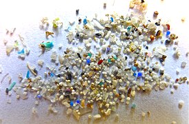 Microplastics found in sediments on the seafloor
 -
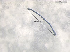 640 µm microplastic found in the deep sea amphipod Eurythenes plasticus

_Figure_3.jpg)
There are also negative anthropogenic impacts on deep sea habitats, including trash pollution and chemical pollution.
Gallery
-
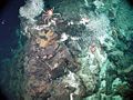
 Deepseamushroom corals growing on the chimney of an Explorer Ridgehydrothermal vent
 -
 Deep sea crab found on hydrothermal vents in the Philippine Sea
 -
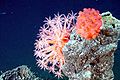
 Deep sea anemone onBlake Ridge
 -
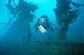 Submerged wrecks create artificial reef habitat
 -
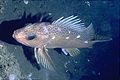 Versatile rockfish can be found living in almost any habitat from rocky bottoms to sand and mud, and from vertical faces to horizontal plains.
 -
 Marine life within the kelp forest and rocky reef habitat
 -
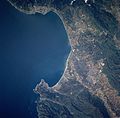 Monterey Bay, the largest marine sanctuary in the United States, is home to the world's largest group of marine research institutions
 -
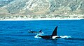 Thekiller whale, apex predatorof the ocean, cruises a huge range of different marine habitats
 -
 Laysan albatross chick in a contemporary modified habitat, surrounded by human marine debris
 -
 Zooarium chimney provides a habitat for vent biota


See also
- Effects of climate change on oceans
- Future of Marine Animal Populations
- Maritime forest
- Seashore wildlife
- Underwater habitat (underwater habitats for humans)
References
- ^ Abercrombie, M., Hickman, C.J. and Johnson, M.L. 1966.A Dictionary of Biology. Penguin Reference Books, London
- ^ Living Ocean NASA Science. Retrieved 17 December 2016.
- ^ The World's Oceans and Seas. Archived 2006-02-24 at the Wayback Machine Encarta. Retrieved 19 April 2008.
- ^ CIA Factbook: Pacific ocean. Archived 2008-08-13 at the Wayback Machine
- ^ CIA Factbook: Atlantic ocean.
- ^ CIA Factbook: Indian ocean.
- ^ CIA Factbook: Southern ocean.
- ^ CIA Factbook: Arctic ocean.
- ^ Elert, Glenn Volume of Earth's Oceans. The Physics Factbook. Retrieved 19 April 2008.
- ^ Where is Earth's water?, United States Geological Survey.
- , 2010.
- ^ Water in Crisis: Chapter 2, Peter H. Gleick, Oxford University Press, 1993.
- ^ Planet "Earth": We Should Have Called It "Sea" Quote Invertigator, 25 January 2017.
- ^ Unveiling Planet Ocean NASA Science, 14 March 2002.
- S2CID 129262186. Retrieved 4 February 2007.
- PMID 21141663. Archived from the original(PDF) on 1 March 2016.
- ^ a b c Ocean Habitats Archived 2011-05-23 at the Wayback Machine Marietta College. Retrieved 17 April 2011.
- ^ Giovanni Coco, Z. Zhou, B. van Maanen, M. Olabarrieta, R. Tinoco, I. Townend. Morphodynamics of tidal networks: Advances and challenges. Marine Geology Journal. 1 December 2013.
- ^ Sandwell, D. T.; Smith, W. H. F. (7 July 2006). "Exploring the Ocean Basins with Satellite Altimeter Data". NOAA/NGDC. Retrieved 21 April 2007.
- hdl:1912/3862.
- ^ ISBN 978-0-7167-2829-0.
- ^ Spalding, Mark, Corinna Ravilious, and Edmund Green. 2001. World Atlas of Coral Reefs. Berkeley, CA: University of California Press and UNEP/WCMC.
- ISBN 978-0-415-21770-5.
- ^ Davidson (2002), p.421.
- ISBN 978-0-495-11286-0
- ^ Easterbrook (1999).
- ^ a b Shepard FP (1937) Revised "Classification of Marine Shorelines" The Journal of Geology, 45(6): 602–624.
- ^ a b c Habitats: Beaches - Coasts Archived 2011-04-26 at the Wayback Machine Office of Naval Research. Retrieved 17 April 2011.
- ^ Continental shelf areas Archived 2008-12-02 at the Wayback Machine Earth trends. Retrieved 25 February 2010.
- ^ World The World Factbook, CIA. Retrieved 26 February 2010.
- ^ Moyle and Cech, 2004, page 572
- ISBN 978-0-08-037718-6. Retrieved 21 November 2008.)
{{cite book}}: CS1 maint: multiple names: authors list (link - ^ a b c Habitats: Beaches - Characteristics Archived 2011-05-26 at the Wayback Machine Office of Naval Research. Retrieved 17 April 2011.
- ^ Habitats: Beaches - Animal & Plant Life Archived 2011-05-26 at the Wayback Machine Office of Naval Research. Retrieved 17 April 2011.
- ^ Wentworth CK (1922) "A scale of grade and class terms for clastic sediments" J. Geology, 30: 377–392.
- ^ a b c Tour of Rocky Shoreline Habitats Archived 2011-05-24 at the Wayback Machine Marietta College. Retrieved 17 April 2011.
- ^ "Mangal (Mangrove). World Vegetation. Mildred E. Mathias Botanical Garden, University of California at Los Angeles". Archived from the original on 9 February 2012.
- ^ a b "Mangrove Morphology & Physiology". www.nhmi.org. Archived from the original on 4 February 2012.
- ISBN 0-19-850222-2
- ^ Pritchard, D. W. (1967) What is an estuary: physical viewpoint. p. 3–5 in: G. H. Lauf (ed.) Estuaries, A.A.A.S. Publ. No. 83, Washington, D.C.
- ISBN 0-19-852508-7
- ^ ISBN 978-0-444-53066-0
- ^ Bronwyn M. Gillanders, Evidence of connectivity between juvenile and adult habitats for mobile marine fauna: an important component of nurseries. 2003. Marine Ecology Progress Series
- ^ Jennifer A. Gill, The buffer effect and large-scale population regulation in migratory birds. 2001. Nature 412, 436-438
- ^ a b Mann, K.H. 1973. Seaweeds: their productivity and strategy for growth. Science 182: 975-981.
- ^ Jackson, G.A. and C.D. Winant. 1983. Effect of a kelp forest on coastal currents. Continental Shelf Report 2: 75-80.
- ^ Steneck, R.S., M.H. Graham, B.J. Bourque, D. Corbett, J.M. Erlandson, J.A. Estes and M.J. Tegner. 2002. Kelp forest ecosystems: biodiversity, stability, resilience and future. Environmental Conservation 29: 436-459.
- ^ Sala, E., C.F. Bourdouresque and M. Harmelin-Vivien. 1998. Fishing, trophic cascades, and the structure of algal assemblages: evaluation of an old but untested paradigm. Oikos 82: 425-439.
- ^ a b c Dayton, P.K. 1985a. Ecology of kelp communities. Annual Review of Ecology and Systematics 16: 215-245.
- ^ Jones, C.G., J. H. Lawton and M. Shachak. 1997. Positive and negative effects of organisms as physical ecosystem engineers. Ecology 78: 1946-1957.
- ^ a b Druehl, L.D. 1981. The distribution of Laminariales in the North Pacific with reference to environmental influences. Proceedings of the International Congress on Systematic Evolution and Biology 2: 248-256.
- ^ Wheeler, W.N. 1980. Effect of boundary layer transport on the fixation of carbon by the giant kelp Macrocystis pyrifera. Marine Biology 56: 103-110.
- ^ Steneck, R.S. and M.N. Dethier. 1994. A functional group approach to the structure of algal-dominated communities. Oikos 69: 476-498.
- ^ Laffoley, Dan (26 December 2009). "To Save the Planet, Save the Seas". The New York Times. Retrieved 17 April 2011.
- ^ a b "Resource Library: Encyclopedic Entry: Reef". nationalgeographic.org. Washington, DC: National Geographic Society. 30 September 2011. Retrieved 15 March 2021.
- ^ US Department of Commerce, National Oceanic and Atmospheric Administration. "How Do Coral Reefs Form: Corals Tutorial". oceanservice.noaa.gov. Retrieved 16 January 2022.
- ^ NOAA (1998) Record-breaking coral bleaching occurred in tropics this year. National Oceanic and Atmospheric Administration, Press release (October 23, 1998).
- ^ ICRS (1998) Statement on Global Coral Bleaching in 1997-1998. International Coral Reef Society, October 15, 1998.
- ^ Bryant, D., Burke, L., McManus, J., et al. (1998) "Reefs at risk: a map-based indicator of threats to the world's coral reefs". World Resources Institute, Washington, D.C.
- ^ Goreau, T. J. (1992) "Bleaching and Reef Community Change in Jamaica: 1951 - 1991". Am. Zool. 32: 683-695.
- ^ Sebens, K. P. (1994) "Biodiversity of Coral Reefs: What are We Losing and Why?" Am. Zool., 34: 115-133
- ^ Wilkinson, C. R., and Buddemeier, R. W. (1994) "Global Climate Change and Coral Reefs:Implications for People and Reefs". Report of the UNEP-IOC-ASPEI-IUCN Global Task Team on the Implications of Climate Change on Coral Reefs. IUCN, Gland, Switzerland.
- ^ a b c d e Ocean ecology: sunlit surface waters WWF. Retrieved 17 May 2011.
- ^ ISSN 2325-1026.
- ^ Blue Planet: Open ocean WWF. Retrieved 17 May 2011.
- doi:10.3389/fmars.2017.00222..
 Material was copied from this source, which is available under a Creative Commons Attribution 4.0 International License
 - ^ Moyle and Cech, 2004, page 585
- ^ US Department of Commerce, National Oceanic and Atmospheric Administration. "What is marine snow?". oceanservice.noaa.gov. Retrieved 28 June 2022.
- ^ Moyle and Cech, 2004, p. 591
- ^ Haedrich RL (1996) "Deep-water fishes: evolution and adaptation in the earth's largest living spaces" Journal of Fish Biology 49(sA):40-53.
- ^ Moyle and Cech, 2004, page 586
- ISBN 978-0-12-547665-2.
- ^ Seven Miles Down: The Story of The Bathyscaph Trieste. Archived 2007-02-02 at the Wayback Machine, Rolex Deep Sea Special, January 2006.
- S2CID 84996718.
- S2CID 214704574.
- ISSN 2073-4441.
- S2CID 2840371.
- PMID 31036875.
- .
- ^ S2CID 234024346.
- S2CID 234849315.
- S2CID 6539536.
Sources
- Kritzer JP; Sale PF (2006). Marine metapopulations. Academic Press. ISBN 978-0-12-088781-1.
- Moyle, PB and Cech, JJ (2004) Fishes, An Introduction to Ichthyology. 5th Ed, Benjamin Cummings. ISBN 978-0-13-100847-2.
- Nybakken JW; Bertness MD (2005) Marine biology: an ecological approach. Sixth edition. Pearson/Benjamin Cummings. ISBN 978-0-8053-4582-7– organized by habitat, not classification
- Pidwirny, Michael (2006). "Fundamentals of Physical Geography (2nd Edition)". PhysicalGeography.net. Retrieved 19 April 2011.
External links

Fishery science topics | |||||||||||||||||||||
|---|---|---|---|---|---|---|---|---|---|---|---|---|---|---|---|---|---|---|---|---|---|
| |||||||||||||||||||||
| |||||||||||||||||||||

