
Matamata
Matamata | |
|---|---|
UTC+13 (NZDT) | |
| Postcode | 3400 |
| Area code | 07 |
Matamata (Māori:
A nearby farm was the location for the Hobbiton Movie Set in Peter Jackson's The Lord of the Rings. The New Zealand government decided to leave the Hobbit holes built on location as tourist attractions. During the period between the filming of The Lord of the Rings: The Return of the King and The Hobbit: An Unexpected Journey they had no furniture or props, but could be entered with vistas of the farm viewed from inside them.[3] A "Welcome to Hobbiton" sign has been placed on the main road. In 2011, parts of Hobbiton began to close in preparation for the three new movies based on the first Tolkien novel, The Hobbit.
Demographics
Matamata covers 6.15 km2 (2.37 sq mi)[1] and had an estimated population of 9,130 as of June 2023,[2] with a population density of 1,485 people per km2.
| Year | Pop. | ±% p.a. |
|---|---|---|
| 2006 | 6,297 | — |
| 2013 | 7,086 | +1.70% |
| 2018 | 7,806 | +1.95% |
| Source: [4] | ||

Matamata had a population of 7,806 at the
Ethnicities were 84.5% European/Pākehā, 15.7% Māori, 1.7% Pacific peoples, 5.9% Asian, and 1.4% other ethnicities. People may identify with more than one ethnicity.
The percentage of people born overseas was 16.6, compared with 27.1% nationally.
Although some people chose not to answer the census's question about religious affiliation, 49.2% had no religion, 37.2% were Christian, 1.2% had Māori religious beliefs, 1.0% were Hindu, 0.2% were Muslim, 0.7% were Buddhist and 1.8% had other religions.
Of those at least 15 years old, 678 (10.5%) people had a bachelor's or higher degree, and 1,848 (28.7%) people had no formal qualifications. 774 people (12.0%) earned over $70,000 compared to 17.2% nationally. The employment status of those at least 15 was that 2,763 (43.0%) people were employed full-time, 849 (13.2%) were part-time, and 198 (3.1%) were unemployed.[4]
| Name | Area (km2) |
Population | Density (per km2) |
Households | Median age | Median income |
|---|---|---|---|---|---|---|
| Matamata North | 2.13 | 3,174 | 1,490 | 1,326 | 46.5 years | $27,100[5] |
| Matamata South | 4.03 | 4,632 | 1,149 | 1,785 | 45.7 years | $26,800[6] |
| New Zealand | 37.4 years | $31,800 |
History
In the early nineteenth century, the area including and surrounding the present-day Matamata township was part of the territory of the Ngāti Hinerangi iwi and
The first European thought to have visited the Matamata area was the trader
Peria, on the outskirts of Matamata, was the scene of the Kīngitanga meeting of 1863.[8][9]
Firth's estate later failed and by 1904 had been wholly obtained by the Crown and was subdivided into dairy farm units[10] to take advantage of the new technology of refrigeration.[11] It became a dependent Town District in 1917, an independent Town District in 1919 and was constituted a borough in 1935.[7] With the re-organisation of territorial authorities in New Zealand in 1989, Matamata became part of the Matamata-Piako District.
Railway station

Matamata was a station on the Kinleith Branch, from Monday 8 March 1886.[14] It was built by Mr D Fallon for the Thames Valley & Rotorua Railway Co. New Zealand Railways Department took over the line on 1 April 1886.[15] Initially 40 minutes north of the temporary terminus at Oxford (Tirau) and about an hour from Morrinsville.[16] For a while Matamata seems to have become a flag station,[17][18] though it did have cattle yards and a 60 ft (18 m) by 30 ft (9.1 m)[15] a goods shed.[19] By 1886 it also had a coal shed able to hold 50 tons, a stationmaster's house, 2 cottages, urinals and a 20,000 imp gal (91,000 L) brick water tank supplied by a 60 ft (18 m) diameter windpump from a well, which was deepened that year. By 1896 Matamata had gained a 4th class station, platform, cart approach and a passing loop for 32 wagons. A telephone came in 1912 and a verandah in 1914. Authority to shift the verandah at Avondale station to Matamata when new station is built, and re-erect, amount £35. House for stationmaster. Platform extended to 175 feet. To extend it to 300 feet will cost £90. Authority for £60 for platform extension. 1919 extension of the verandah have been authorised. In 1919 part of the old Drury station building was erected as a luggage room at Matamata. Improvements are to be put in hand, estimated cost £6,000. Lighting of station and houses. 1927 Additional seating accommodation on platform. 1953 Approval for bicycle shed, estimated cost £90.[15] There was a Post Office at the station until 1911.[15] It had two members of staff from 1913.[20] Matamata was included in the annual returns of railway traffic. For example, in 1924 it sold 26,367 tickets and exported 26,084 sheep and pigs.[21] In 1950 8,868 tickets were sold and it transported 42,322 sheep and pigs.[22] A petrol engined shunter was used in the station yard from 1936.[23] Several Drewry 0-4-0 shunters were introduced in 1936.[24]
The station building was replaced on Monday 17 May 1965 by a new £23,500 steel
Matamata closed to passengers on 12 November 1968,[14] but reopened to serve the Geyserland Express[25] from 9 December 1991 until 7 October 2001.[26]
Since closure the station has been the Railside by the Green community centre since 2002,[27] though it is fenced off from the platform.[28] Occasional excursions still use the platform.[29][30]
Sports
Matamata is home to the
Educational institutions
Matamata College is the town's co-educational state secondary school,[32][33] with a roll of 781 as of February 2024.[34]
Matamata Intermediate is the town's co-educational state intermediate school,[35][36] with a roll of 431.[37]
There are two co-educational state primary schools: Matamata Primary School,[38][39] with a roll of 436;[40] and Firth School,[41] with a roll of 188.[42] The motto for Firth School is E Tipu E Rea, which translates as Grow and Flourish.[43]
Matamata Christian School is a co-educational state integrated Christian primary school,[44][45] with a roll of 98.[46]
St Joseph's Catholic School is a co-educational state integrated Catholic school,[47] with a roll of 32.[48]
-
 Aerial view of Matamata College in the 1940s
 -
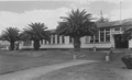 Front of Matamata College in the 1950s
 -
 Matamata Public School from around 1909.
 -
 Matamata Public School around 1919.


.jpg)
Notable people
- Shane Dye
- Casey Kopua
- Lance O'Sullivan
- Tim Mikkelson
- Hon Mike Rann CNZM
- Dame Patsy Reddy
- Dame Catherine Tizard
- Matthew Stanley
- Claudia Pond Eyley
- Kyle Wealleans
- Kristine Crabb
- Tom Sainsbury
Nearby towns
Smaller towns nearby are:
- Hinuera
- Peria
- Turanga-O-Moana
- Te Poi
- Waharoa
- Walton, New Zealand
- Wardville, New Zealand
See also
References
- ^ a b "ArcGIS Web Application". statsnz.maps.arcgis.com. Retrieved 13 October 2022.
- ^ a b c "Subnational population estimates (RC, SA2), by age and sex, at 30 June 1996-2023 (2023 boundaries)". Statistics New Zealand. Retrieved 25 October 2023. (regional councils); "Subnational population estimates (TA, SA2), by age and sex, at 30 June 1996-2023 (2023 boundaries)". Statistics New Zealand. Retrieved 25 October 2023. (territorial authorities); "Subnational population estimates (urban rural), by age and sex, at 30 June 1996-2023 (2023 boundaries)". Statistics New Zealand. Retrieved 25 October 2023. (urban areas)
- ^ "Matamata Area Guide". Archived from the original on 17 February 2009. Retrieved 7 January 2009.
- ^ a b "Statistical area 1 dataset for 2018 Census". Statistics New Zealand. March 2020. Matamata North (174900) and Matamata South (175000).
- ^ 2018 Census place summary: Matamata North
- ^ 2018 Census place summary: Matamata South
- ^ a b c d e 'MATAMATA', from An Encyclopaedia of New Zealand, edited by A. H. McLintock, originally published in 1966. Te Ara – the Encyclopedia of New Zealand, updated 22 April 2009
- ^ Peria Topo Map
- ^ "Maori Report Of The Speeches At The Meeting At Peria". Press. 3 January 1863. p. 3. Retrieved 20 June 2016.
- ^ D. B. Waterson. 'Firth, Josiah Clifton', from the Dictionary of New Zealand Biography. Te Ara – the Encyclopedia of New Zealand, updated 18-Sep-2013
- ^ Waterson, D. B. (1969). "The Matamata Estate, 1904-1959: Land Transfers and Subdivision in the Waikato" (PDF). New Zealand Journal of History. 3 (1): 36.
- ^ "Beautifying on the Railways — Activities Of The Railway Department. — Trees and Gardens. — Co-operation of Local Bodies and Clubs". nzetc.victoria.ac.nz. Retrieved 20 April 2021.
- ^ "Matamata-Piako District Plan". www.mpdc.govt.nz. Retrieved 31 May 2018.
- ^ a b Scoble, Juliet (2010). "Names & Opening & Closing Dates of Railway Stations" (PDF). Rail Heritage Trust of New Zealand.
- ^ a b c d e "Stations" (PDF). NZR Rolling Stock Lists. Retrieved 10 August 2020.
- ^ "Page 7 Advertisements Column 4". Te Aroha News. 29 May 1886. p. 7. Retrieved 31 May 2018.
- ^ "Matamata". nzetc.victoria.ac.nz. 1902. Retrieved 31 May 2018.
- ^ Representatives, New Zealand Parliament House of (1908). Parliamentary Debates.
- ^ "Railway Station Matamata, showing two steam locomotive trains stopped". www.aucklandcity.govt.nz. Retrieved 31 May 2018.
- ^ "Parliamentary Papers | Appendix to the Journals of the House of Representatives | 1913 Session I". paperspast.natlib.govt.nz. Retrieved 31 May 2018.
- ^ "RAILWAYS STATEMENT BY THE MINISTER OF RAILWAYS, HON. J.G. COATES". paperspast.natlib.govt.nz. 1924. Retrieved 20 April 2021.
- ^ "Parliamentary Papers | Appendix to the Journals of the House of Representatives | 1950 Session I". paperspast.natlib.govt.nz. Retrieved 31 May 2018.
- ^ "LOCAL AND GENERAL. THAMES STAR". paperspast.natlib.govt.nz. 11 November 1936. Retrieved 20 April 2021.
- ^ "New Zealand Rolling Stock Register". www.nzrsr.co.nz. Retrieved 21 April 2021.
- ^ "Inter-regional Rail service distances and times". www.bettertransport.org.nz. Retrieved 31 May 2018.
- ^ "Passenger rail routes farewelled | NATIONAL News". 7 October 2001. Archived from the original on 16 May 2011. Retrieved 20 April 2021.
- ^ "home". www.railsidematamata.co.nz. Retrieved 31 May 2018.
- ^ "Matamata: New Zealand's re-cycled Station". Phillip Overton. 13 December 2013. Retrieved 31 May 2018.
- ^ "Photos – Silver Fern to Matamata". nzrailphotos.co.nz. Retrieved 31 May 2018.
- ^ "Glenbrook to Matamata & Return – Waikato Explorer – RES Excursions – Glenbrook Vintage Railway". www.gvr.co.nz. Retrieved 31 May 2018.
- ISBN 9780900609923.
- ^ "Matamata College Official School Website". matamatacollege.school.nz.
- ^ "Matamata College Ministry of Education School Profile". educationcounts.govt.nz. Ministry of Education.
- Education Review Office.
- ^ "Matamata Intermediate Official School Website". matamataintermediate.school.nz.
- ^ "Matamata Intermediate Ministry of Education School Profile". educationcounts.govt.nz. Ministry of Education.
- Education Review Office.
- ^ "Matamata Primary School Official School Website". matamataprimary.school.nz.
- ^ "Matamata Primary School Ministry of Education School Profile". educationcounts.govt.nz. Ministry of Education.
- Education Review Office.
- ^ "Firth School Ministry of Education School Profile". educationcounts.govt.nz. Ministry of Education.
- Education Review Office.
- ^ "Firth School Official School Website". firth.school.nz.
- ^ "Matamata Christian School Official School Website". matamata.school.nz.
- ^ "Matamata Christian School Ministry of Education School Profile". educationcounts.govt.nz. Ministry of Education.
- Education Review Office.
- ^ "St Joseph's Catholic School Ministry of Education School Profile". educationcounts.govt.nz. Ministry of Education.
- Education Review Office.
| International | |
|---|---|
| National | |