
Mayer, Arizona
Mayer, Arizona | ||
|---|---|---|
CDP | ||
FIPS code 04-45180 | | |
| GNIS feature ID | 31605 | |
Mayer is a
History
The place was originally called Wi:kidoʼyoʼ in
2017 wildfire
The Goodwin Fire sparked on June 24, 2017, in the
Geography
Mayer is located at 34°25′9″N 112°14′59″W / 34.41917°N 112.24972°W (34.419154, −112.249779).[6]
According to the United States Census Bureau, the CDP has a total area of 20.1 square miles (52 km2), all land.
Climate
According to the
Demographics
| Census | Pop. | Note | %± |
|---|---|---|---|
| 2000 | 1,408 | — | |
| 2010 | 1,497 | 6.3% | |
| 2020 | 1,558 | 4.1% | |
| U.S. Decennial Census[8] | |||

At the
The age distribution was 24% under the age of 18, 6% from 18 to 24, 23% from 25 to 44, 28% from 45 to 64, and 19% 65 or older. The median age was 44 years. For every 100 females, there were 99.2 males. For every 100 females age 18 and over, there were 97.6 males.
The median household income was $28,412 and the median family income was $33,988. Males had a median income of $38,304 versus $21,417 for females. The per capita income for the CDP was $14,297. About 14% of families and 19% of the population were below the
Education
Most of Mayer CDP is in the
National Register of Historic Places
The following pictured properties in Mayer are listed in the National Register of Historic Places:[11]

-
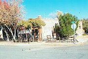 Historic Mayer Business Block.
 -
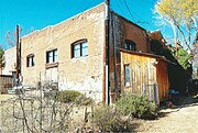 Rear view of the Mayer General Market Store.
 -
 Mayer Apartment #1.
 -
 Mayer Apartment #2.
 -
 Mayer Red Brick Schoolhouse.
-Historic_Mayer_Business_Block-1902.jpg)


See also
References
- ^ "2020 U.S. Gazetteer Files". United States Census Bureau. Retrieved October 29, 2021.
- ^ http://www.ansac.az.gov/UserFiles/PDF/10132015/C028_SLD-AG%20Supplement%202/298%20-%20Gifford,%20Northeastern%20and%20Western%20Yavapai.pdf [bare URL PDF]
- ^ Masumoto, Marie. "Mayer (detention facility)" Densho Encyclopedia. Retrieved June 23, 2014.
- ^ "One year anniversary of Goodwin Fire". fox10phoenix.com. Fox10. June 21, 2018. Retrieved April 24, 2021.
- ^ "Goodwin Fire Firefighter Injury". walkercommunity.com. Conrad Walton. July 2017. Retrieved September 26, 2021.
- ^ "US Gazetteer files: 2010, 2000, and 1990". United States Census Bureau. February 12, 2011. Retrieved April 23, 2011.
- ^ Climate Summary for Mayer, Arizona
- ^ "Census of Population and Housing". Census.gov. Retrieved June 4, 2016.
- ^ "U.S. Census website". United States Census Bureau. Retrieved January 31, 2008.
- U.S. Census Bureau. Retrieved January 30, 2022.
- ^ National Register of Historic Properties: Yavapai County
External links
![]() Media related to Mayer, Arizona at Wikimedia Commons
Media related to Mayer, Arizona at Wikimedia Commons
 | ||||
Towns |
| |||
| CDPs | ||||
| Populated places |
| |||
| Indian reservations |
| |||
| Ghost towns | ||||
| Footnotes | ‡This populated place also has portions in an adjacent county or counties | |||
| ||||
| International | |
|---|---|
| National | |