
Meiktila
Meiktila
မိတ္ထီလာမြို့ | |
|---|---|
City | |
MST ) |
Meiktila (
History

The name Meiktila comes from Mithila, the name of an ancient Indian kingdom.
The history of Meiktila is closely tied to that of central Myanmar's Dry Zone, home of the Bamar people. The region had been part of various Bamar kingdoms at least from 11th century CE to 19th century CE before the British Empire took over all of Upper Myanmar in 1885.
Meiktila was part of the 1945 Battle of Meiktila and Mandalay, during which the Allied forces under William Slim defeated the Japanese forces. Soon after Burma's independence from Britain in 1948, Meiktila briefly fell under the insurgent Karen forces.
On 22 March 2013, a state of emergency was imposed in the town after
Geography
Meiktila district is the most easterly of the districts in Myanmar's central dry zone.
Climate
Meiktila has a
| Climate data for Meiktila (1991–2020) | |||||||||||||
|---|---|---|---|---|---|---|---|---|---|---|---|---|---|
| Month | Jan | Feb | Mar | Apr | May | Jun | Jul | Aug | Sep | Oct | Nov | Dec | Year |
| Record high °C (°F) | 37.0 (98.6) |
39.5 (103.1) |
41.5 (106.7) |
43.0 (109.4) |
44.0 (111.2) |
40.0 (104.0) |
41.2 (106.2) |
37.0 (98.6) |
37.0 (98.6) |
37.0 (98.6) |
36.0 (96.8) |
36.0 (96.8) |
44.0 (111.2) |
| Mean daily maximum °C (°F) | 30.1 (86.2) |
33.5 (92.3) |
36.9 (98.4) |
38.7 (101.7) |
36.3 (97.3) |
33.4 (92.1) |
32.9 (91.2) |
32.4 (90.3) |
32.9 (91.2) |
32.6 (90.7) |
31.2 (88.2) |
29.3 (84.7) |
33.3 (91.9) |
| Daily mean °C (°F) | 22.4 (72.3) |
25.1 (77.2) |
29.0 (84.2) |
31.9 (89.4) |
30.8 (87.4) |
29.1 (84.4) |
28.7 (83.7) |
28.4 (83.1) |
28.6 (83.5) |
28.0 (82.4) |
25.7 (78.3) |
22.7 (72.9) |
27.5 (81.5) |
| Mean daily minimum °C (°F) | 14.6 (58.3) |
16.7 (62.1) |
21.2 (70.2) |
25.1 (77.2) |
25.3 (77.5) |
24.7 (76.5) |
24.5 (76.1) |
24.3 (75.7) |
24.3 (75.7) |
23.5 (74.3) |
20.1 (68.2) |
16.2 (61.2) |
21.7 (71.1) |
| Record low °C (°F) | 9.0 (48.2) |
10.0 (50.0) |
12.0 (53.6) |
18.3 (64.9) |
19.0 (66.2) |
20.0 (68.0) |
19.0 (66.2) |
20.2 (68.4) |
20.0 (68.0) |
16.2 (61.2) |
12.7 (54.9) |
10.0 (50.0) |
9.0 (48.2) |
| Average precipitation mm (inches) | 4.3 (0.17) |
1.3 (0.05) |
5.1 (0.20) |
28.7 (1.13) |
141.0 (5.55) |
110.5 (4.35) |
77.5 (3.05) |
133.5 (5.26) |
165.1 (6.50) |
152.5 (6.00) |
34.4 (1.35) |
8.0 (0.31) |
861.9 (33.93) |
| Average precipitation days (≥ 1.0 mm) | 0.6 | 0.3 | 0.7 | 2.5 | 9.6 | 10.1 | 9.3 | 12.9 | 12.1 | 9.9 | 3.0 | 1.0 | 71.9 |
| Source: World Meteorological Organization[8] | |||||||||||||
Culture
Meiktila has 44 Buddhist pagodas as of 2020. The most well-known pagodas are located on the lakefront, although they exist throughout the town in both upland and lowland areas. Below is a table of 10 of the main pagodas in Meiktila:[7]: 235–7
| Pagoda name[7]: 237 | Location[7]: 237 | Type of structure[7]: 237–9 | Date of present structure (if listed)[7]: 240 | Donor (if known)[7]: 240 |
|---|---|---|---|---|
| Shwe Myin Tin | Yadana Man Aung | Stupa with spire | 1112 | Narapati Sithu |
| Phaung Taw U | Myoma Lay | Stupa only | ||
| Su Taung Pyi | Myoma Lay | Stupa only | 1888 | Narapati Sithu |
| Naga Yone Maha Bodhi | Nantaw Gone | Stupa with temple | 11.5% | Narapati Sithu |
| Chantha Gyi | Ashae Byin | Stupa only | Narapati Sithu | |
| Aung Theikdi | Near Seven Waterfalls | Stupa only | 2000 | |
| Aunt Ta Ku | Nantaw Gone | Stupa only | ||
| Wun Taw Pyi | Kyitaw Gone | Stupa with temple | 1853 | Naung Taung Mya (early 1200s) |
| Shwe Saw Lu | Nantaw Gone | Stupa with spire | Saw Lu Min and Narapati Sithu | |
| Htee Thone Sint | Wunzin | Stupa with spire | 1201 | Narapati Sithu |
Other, lesser-visited pagodas include ones in the Aung Zaya and Yan Myo Aung quarters.[7]: 237
The city's well-known pagodas are Shwemyintin, Shweyinmi (asa Hteethonesint),
Education
Meiktila is home to the
Of the city's six public
Military
Meiktila is home to two Myanmar Air Force air bases:
- Meiktila Air Base and home to Central Command
- Shante Air Base - located north of Meiktila in Pyitharyar
Gallery
-
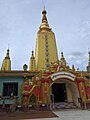 Nagayon pagoda
 -
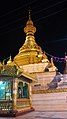 Shwe Myin Tin pagoda
 -
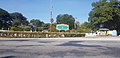
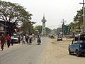 Clock tower in central Meiktila
 -
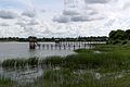 View of Meiktila Lake
 -
 Aunt Ta Ku pagoda, built on a pier in the lake
 -
 Shante Airbase entrance
 -
 Meiktila Education College entrance


References
- ^ Min Lwin (2008-12-01). "Junta Orders Major Air Force Base Relocated". The Irrawaddy News. Archived from the original on 2008-12-11.
- ^ "Population of Cities in Myanmar (2021)". worldpopulationreview.com. Retrieved 2021-04-01.
- ^ "Burma: State of emergency imposed in Meiktila". BBC News. 2013-03-22. Retrieved 2023-01-31.
- ISSN 0362-4331. Retrieved 2023-03-25.
- ISSN 0013-0613. Retrieved 2023-03-25.
- ^ a b Chisholm, Hugh, ed. (1911). . Encyclopædia Britannica. Vol. 18 (11th ed.). Cambridge University Press. pp. 82–83.
- ^ a b c d e f g h Moe Moe Oo; Thida Myint; Hninn Ngwe; Su Su Win; Sein Sein Win; Soe Soe (2020). "Buddhist Culture in Meiktila" (PDF). University of Mandalay Research Journal. 11: 235–43. Retrieved 12 December 2023.
- ^ "World Meteorological Organization Climate Normals for 1991–2020". World Meteorological Organization. Retrieved 16 October 2023.
20°53′N 95°53′E / 20.883°N 95.883°E
Capital: Mandalay | ||
| Kyaukse District |   | |
| Mandalay District | ||
| Meiktila District | ||
| Myingyan District | ||
| Nyaung-U District | ||
Pyinoolwin District | ||
| Yamethin District | ||
| Main cities and towns | ||