
Merck-Saint-Liévin
You can help expand this article with text translated from the corresponding article in French. (September 2021) Click [show] for important translation instructions.
|
Merck-Saint-Liévin | |
|---|---|
 Aa river | |
 Coat of arms | |
Location of Merck-Saint-Liévin  | |
 Merck-Saint-Liévin  Merck-Saint-Liévin | |
| Coordinates: 50°37′40″N 2°06′55″E / 50.6278°N 2.1153°E | |
| Country | France |
| Region | Hauts-de-France |
| Department | Pas-de-Calais |
| Arrondissement | Saint-Omer |
| Canton | Fruges |
| Intercommunality | Pays de Saint-Omer |
| Government | |
| • Mayor (2020–2026) | Philippe Hochart[1] |
| Area 1 | 11.85 km2 (4.58 sq mi) |
| Population (2021)[2] | 674 |
| • Density | 57/km2 (150/sq mi) |
| Time zone | UTC+01:00 (CET) |
| • Summer (DST) | UTC+02:00 (CEST) |
| INSEE/Postal code | 62569 /62560 |
| Elevation | 56–172 m (184–564 ft) (avg. 68 m or 223 ft) |
| 1 French Land Register data, which excludes lakes, ponds, glaciers > 1 km2 (0.386 sq mi or 247 acres) and river estuaries. | |
Merck-Saint-Liévin (French pronunciation: West Flemish: Sint-Lievens-Merk) is a commune in the Pas-de-Calais department in the Hauts-de-France region of France.[3]
Geography
Merck-Saint-Liévin lies about 10 miles (16 km) southwest of Saint-Omer, on the D225 roads. The river Aa flows through the village.
Toponym
The name apparently refers to Saint Livinus of Ghent (martyred in 657 or 663), an Irish bishop who evangelized Flanders and Brabant, and is highly venerated in northern France.
Population
| Year | Pop. | ±% p.a. |
|---|---|---|
| 1968 | 550 | — |
| 1975 | 547 | −0.08% |
| 1982 | 514 | −0.88% |
| 1990 | 517 | +0.07% |
| 1999 | 507 | −0.22% |
| 2007 | 569 | +1.45% |
| 2012 | 620 | +1.73% |
| 2017 | 656 | +1.14% |
| Source: INSEE[4] | ||
Places of interest
- An eighteenth-century mill.
- The church of St. Omer, dating from the seventeenth century
-
 View from the south
 -
 Cemetery gate
 -
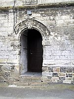 The side entrance
 -
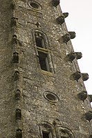 Features on the spire
 -
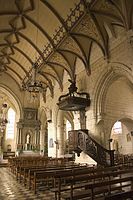 The nave
 -
 The font


See also
References
- ^ "Répertoire national des élus: les maires" (in French). data.gouv.fr, Plateforme ouverte des données publiques françaises. 13 September 2022.
- ^ "Populations légales 2021". The National Institute of Statistics and Economic Studies. 28 December 2023.
- ^ INSEE commune file
- ^ Population en historique depuis 1968, INSEE
External links
Wikimedia Commons has media related to Merck-Saint-Liévin.
- Statistical data, INSEE
| International | |
|---|---|
| National | |
This Pas-de-Calais geographical article is a stub. You can help Wikipedia by expanding it. |