
Merv
مرو Marw | |
Turkmen | |
| Site notes | |
|---|---|
| Condition | In ruins |
Asia-Pacific | |
 | |
| History of Greater Iran | |
|---|---|
| 1407–1468 | |
| Aq Qoyunlu Turcomans | 1378–1508 |
| Safavid Empire | 1501–1722 |
| Mughal Empire | 1526–1857 |
| Hotak dynasty | 1722–1729 |
| Afsharid Iran | 1736–1750 |
| Zand dynasty | 1750–1794 |
| Durrani Empire | 1794–1826 |
| Qajar Iran | 1794–1925 |
Merv (
Merv was the capital city of several
Merv was also a popular place for
During the 12th and 13th centuries, Merv may have been the world's largest city, with a population of up to 500,000. During this period, Merv was known as "Marw al-Shāhijān" (Merv the Great), and frequently referred to as the "capital of the eastern Islamic world". According to geographer
Today the site is preserved by the Government of Turkmenistan as the State Historical and Cultural Park "Ancient Merv". It was established in 1987 and is regulated by Turkmenistan's legislation. It is the oldest and most perfectly preserved of the oasis cities along the historical Silk Road in Central Asia. A few buildings and structures still stand today, especially those constructed in the last two millennia. UNESCO has listed the site of ancient Merv as a World Heritage Site.[15]
History
.jpg)
Merv has prehistoric roots: archaeological surveys have revealed many traces of village life as far back as the 3rd millennium BC and have associated the area culturally with the
Under the
Hellenistic era

The Seleucid ruler
Parthian era
After the fall of the Seleucid dynasty (63 BC),
Merv was a major city of
Sasanian era
After the Sasanid
Arab conquest and influence
Merv gained renewed importance in February 748 when the Iranian general
.jpg)
Throughout the Abbasid era, Merv remained the capital and most important city of Khurasan. During this time, the Arab historian
Merv was also known for its high-quality textiles. A 12th-century Arab geographer
In the period from 813 to 818, the temporary residency of the caliph,
During this period Merv, like
As the caliphate weakened, Persian general
Turkmens in Merv
.jpg)
In 1037, the

Nearing the end of the 11th century, Merv became the eastern capital of the split Seljuq state. However, starting from 1118, it served as the capital of the whole empire.[35] During this period, Merv expanded to its greatest size—Arab and Persian geographers termed it "the mother of the world", the "rendezvous of great and small", the "chief city of Khurasan" and the "capital of the eastern Islamic world". Written sources also attest to a large library and madrasa founded by Nizam al-Mulk, vizier of the Seljuq empire, as well as many other major cultural institutions. Perhaps most importantly, Merv had a market described as "the best of the major cities of Iran and Khurasan".[36]
Sanjar's rule, marked by conflict with the
Mongols in Merv
_(44747314854).jpg)
In 1221, Merv opened its gates to Tolui, son of Genghis Khan, chief of the Mongols. Most of the inhabitants are said to have been butchered. Arab historian Ibn al-Athir described the event basing his report on the narrative of Merv refugees:
Genghis Khan sat on a golden throne and ordered the troops who had been seized should be brought before him. When they were in front of him, they were executed and the people looked on and wept. When it came to the common people, they separated men, women, children and possessions. It was a memorable day for shrieking and weeping and wailing. They took the wealthy people and beat them and tortured them with all sorts of cruelties in the search for wealth ... Then they set fire to the city and burned the tomb of Sultan Sanjar and dug up his grave looking for money. They said, 'These people have resisted us' so they killed them all. Then Genghis Khan ordered that the dead should be counted and there were around 700,000 corpses.[8]
A Persian historian,
Excavations revealed the drastic rebuilding of the city's fortifications in the aftermath of their destruction, but the city's prosperity had passed. The Mongol invasion spelled the eclipse of Merv and other major centres for more than a century. After the Mongol conquest, Merv became part of the
Uzbeks in Merv and its final destruction
_%D9%88_%D8%B3%D9%BE%D8%A7%D9%87_%D8%A7%D8%B2%D8%A8%DA%A9_%D8%A8%D9%87_%D9%81%D8%B1%D9%85%D8%A7%D9%86%D8%AF%D9%87%DB%8C_%D8%B4%DB%8C%D8%A8%DA%A9_%D8%AE%D8%A7%D9%86.jpg)
In 1505, the
After Shah Ismail's death, the region became a dependency of
The entire population of the city and the surrounding oasis of about 100,000 were then deported in several stages to the Bukharan oasis and the
Nineteenth century
| History of Turkmenistan |
|---|
.jpg) |
|
|
Merv passed to the
A future viceroy of
Remains
Some exploratory excavations at Merv were conducted in 1885[50] by the Russian general A.V. Komarov, the governor of the Transcaspian oblast, 1883–89; Komarov employed his Tsarist troops as excavators and published his collection of trophy artifacts and coins from the area in 1900.[51] Valentin Alekseevich Zhukovsky of the Imperial Archaeological Commission directed the first fully professional dig in 1890 and published in 1894. Geologist Raphael Pumpelly and a German archaeologist, Hubert Schmidt, directed the American Carnegie Institute's excavations.[52]
Merv is the focus of the Ancient Merv Project (initially called the International Merv Project).[53] From 1992 to 2000, a joint team of archaeologists from Turkmenistan and the UK have made remarkable discoveries. In 2001, the Institute of Archaeology, University College London and the Turkmen authorities started a new collaboration. This Ancient Merv Project is concerned with the complex conservation and management issues posed by this site, furthering understanding of the site through archaeological research, and disseminating the results of the work to the widest possible audience.[54]
Organization of remains
Merv consists of a few discrete walled cities very near to each other constructed on uninhabited land by builders of different eras, used, and then abandoned and never rebuilt. Four walled cities correspond to the chief periods of Merv's importance: the oldest, Erkgala, corresponds to Achaemenid Merv, the smallest of the three. Gäwürgala (also known as Gyaur Gala), which surrounds Erkgala, comprises the
Erk Gala
Gäwürgala
The foundation of Gäwürgala (Turkmen from the Persian "
Gäwürgala's most visible remaining structures are its defensive installations. Three walls, one built atop the next, are in evidence. A Seleucid wall, graduated in the interior and straight on the exterior, forms a platform for the second, larger wall, built of mudbricks and stepped on the interior. The form of this wall is like other Hellenistic fortresses found in
Soltangala
.jpg)
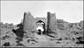
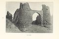
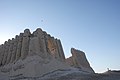
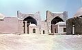
Soltangala (from "Sultan Qala", the sultan's fortress) is by far the largest of Merv's cities. Textual sources establish it was Abu Muslim, the leader of the Abbasid rebellion, who symbolised the beginning of the new Caliphate by commissioning monumental structures to the west of the Gäwürgala walls, in what then became Soltangala.[58] The area was quickly walled and became the core of medieval Merv; the many Abbasid-era köshks (fortified building) discovered in and outside Soltangala attest to the centuries of prosperity which followed. Kushks (Persian, Kushk, "pavilion", "kiosk"), which comprise the chief remains of Abbasid Merv, are a building type unique to Central Asia during this period. A kind of semi-fortified two-story palace, whose corrugated walls give it a unique and striking appearance, köshks were the residences of Merv's elite. The second storey of these structures comprised living quarters; the first storey may have been used for storage. Parapets lined the roof, which was often used for living quarters as well. Merv's largest and best-preserved Abbasid köşk is the Greater Gyzgala (Turkmen, "maiden's fortress"), located just outside Soltangala's western wall; this structure consisted of 17 rooms surrounding a central courtyard. The nearby Lesser Gyzgala had extraordinarily thick walls with deep corrugations, as well as multiple interior stairways leading to second storey living quarters. All of Merv's kushks are in precarious states of preservation.[59]
However, the most important of Soltangala's surviving buildings are Seljuq constructions. Seljuq leader Toghrul's conquest of Merv in 1037 revitalised the city; under his descendants, especially Sanjar, who made it his residence, Merv found itself at the centre of a large multicultural empire.[60]

Evidence of this prosperity is found throughout the Soltangala. Many of these buildings are concentrated in Soltangala's citadel, the Shahryar Ark (Persian, "the Sovereign's citadel"), is on its east side. In the centre of the Sharhryar Ark is the Seljuk palace, probably built by Sanjar. The surviving mud brick walls lead to the conclusion that this palace, though relatively small, was composed of tall, single-storey rooms surrounding a central court along with four axial iwans at the entrance to each side. Low areas nearby seem to indicate a large garden, which included an artificial lake; similar gardens were found in other Central Asian palaces. Any remnants of interior or exterior decoration have been lost because of erosion or theft.[61]
Another notable Seljuk structure within the Shahryar Ark is the kepderihana (from the Persian, "Kaftar Khaneh", or "pigeon house", i.e., the columbarium). This mysterious building, among the best-preserved in the whole Merv oasis, comprises one long and narrow windowless room with many tiers of niches across the walls. Some sources Believe the kepter khana (there are more elsewhere in Merv and Central Asia) was a pigeon roost used to raise pigeons, to collect their dung, which was used in growing the melons for which Merv was famous. Others see the kepderihanas as libraries or treasuries, because of their location in high status areas next to important structures.[62]

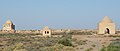
The best-preserved of all the structures in Merv is the 12th-century
A final set of

Many ceramics have been recovered from the Abbasid and Seljuk eras, primarily from Gäwürgala, the city walls of Soltangala, and the Shahryar Ark. The Gäwürgala ware was primarily late Abbasid and consisted primarily of red slip-painted bowls with geometric designs. The pottery recovered from the Sultan Gala walls is dominated by 11th to 12th-century colour-splashed yellow and green pottery, similar to contemporary styles common in
Shaim Kala
Shaim Kala was built in the 7th AD. Shaim Kala was a self-contained walled city intended to relieve over-crowding, and to deal with the religious and political discontent of the newly arrived peoples.[66]
Abdyllahangala
Abdyllahangala is the post medieval
Demographics
Today, the site of the ancient Merv is located near Baýramali city of Mary velayat, Turkmenistan. It is a city in and the seat of
The present inhabitants of the oasis are primarily
Economy

An elaborate system of canals cut from the Murghab irrigates the oasis. The country is renowned throughout the East for its fertility. Every kind of cereal and many fruits grow in great abundance, e.g. wheat, millet, barley and melons, also rice and cotton. Cotton seeds from archaeological levels as far back as the 5th century are the first indication that cotton textiles were already an important economic component of the Sassanian city.
Geography

The oasis of Merv is situated on the Murghab River that flows down from
Merv is advantageously situated in the inland delta of the Murghab River, which flows from its source in the Hindu Kush northwards through the Garagum desert. The Murghab delta region, known to the Greeks as
This place was a stop on the Silk Road during the time of the Han dynasty. Here merchants could trade for fresh horses or camels at this oasis city.[74]
Climate
Merv is dry and hot in summer and cold in winter. The heat of summer is oppressive. The wind raises clouds of fine dust which fill the air, rendering it opaque, almost obscuring the noonday sun. These clouds make breathing difficult. In winter the climate is pleasant. Snow falls rarely, and when it does, it melts at once. The annual rainfall rarely exceeds 125 mm (4.9 in), and there is often no rain from June until October. In summer temperatures can reach 45 °C (113 °F), while in winter they can be as low as −7 °C (19 °F). The average yearly temperature is 16 °C (61 °F).
International relations
UNESCO has listed the site of ancient Merv as a World Heritage Site.[15]
Twin towns – sister cities
Merv is twinned with:
 Aleppo, Syria
 Balkh, Afghanistan
 Baghdad, Iraq
 Bukhara, Uzbekistan
- Damascus, Syria
 Dubai, United Arab Emirates
 Gaza City, Palestine
 Jerusalem, Israel
- Karbala, Iraq
 Khujand, Tajikistan
- Kirkuk, Iraq
 Konye-Urgench, Turkmenistan
 Kuwait City, Kuwait
 Lahore, Pakistan
 Mecca, Saudi Arabia
- Medina, Saudi Arabia
- Nisa, Turkmenistan
 Nishapur, Iran
- Samarkand, Uzbekistan
Gallery
-
 Photo-textured3D laser scanimage of Gäwürgala town walls
 -
 Interior of Kepderihana, with a3D laser scannerpositioned for work
 -
 Landmarks of ancient Merv on a 1993 Russian commemorative coin
 -
 Merv Mosque (end of the 19th century)
 -
 Ancient Merv (end of the 19th century)
 -
 Merv, 1899
 -
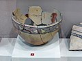 Merv pottery
 -
 Great Kyz Kala
 -
 Interior of the Ice House
 -
 Kyz Bibi mausoleum complex
 -
 1981 photo of the tomb of the Eskhab brothers on the territory of ancient Merv


.png)
.jpg)
.jpg)

.jpg)

.jpg)


See also
- Greater Khorasan
- Nishapur
- Herat
- Balkh
- Gunar Tepe
- Margiana
- List of cities founded by Alexander the Great
- Mary, Turkmenistan
- Bayramali
- Murghab river
- List of World Heritage Sites in Turkmenistan
- Tahmuras, the mythical father and founder of Merv
References
Citations
- doi:10.5334/ai-395.
- ISBN 978-9004153882. Archivedfrom the original on 13 July 2021. Retrieved 1 November 2020.
Merv, the conventional form of the Arabic Marw or Marw al-Shāhijān, an ancient city of the northeastern part of the Iranian world, in medieval Islamic times, in the province of Khurasan. The site of Merv now lies over the border from the Islamic Republic of Iran and within the Turkmen Republic, near the modern town of what was in Soviet times Mary. The form of the name Marw al-Shāhijān clearly related to the city's position in pre-Islamic and early Islamic times as the seat of the representatives of royal authority, the marzbāns of the East, and its role as a bastion of this part of the Iranian world as a bastion against barbarian pressure from the inner Asian steppes.
- ^ Encyclopedia Britannica. Archivedfrom the original on 7 June 2021. Retrieved 9 June 2021.
Al-Maʾmūn, having become caliph of the entire ʿAbbāsid empire, decided to continue to reside at Merv, assisted by his faithful Iranian vizier al-Faḍl.
- ^ Herrmann 1999, p. 33.
- ^ Starr, Frederick (2015). Lost Enlightenment. Central Asia's Golden Age from the Arab Conquest to Tamerlane. Princeton University Press. p. 425.
Sanjar's capital at Merv was not the ancient center around the ErkKala but a ...
- Elsevier Science. p. 232.
Hence under 125000 and probably under 100000—as Merv rose very fast as a Seljuk capital
- ^ Brummel, Paul (2005). Turkmenistan. Bradt Travel Guides. p. 7.
The Seljuks were to establish a mighty empire stretching right to the Mediterranean, with Merv as its capital.
- ^ a b c d e f g Tharoor, Kanishk (12 August 2016). "Lost cities #5: how the magnificent city of Merv was razed – and never recovered". The Guardian. Archived from the original on 29 April 2021. Retrieved 18 March 2019.
- ^ a b "Why was Imam al-Reza (A.S.) Invited to Khurasan?". Imam Reza Network. Retrieved 3 July 2021.
- ^ Encyclopaedia of Islam, Vol. 7 (2nd ed.). Brill. 1993. p. 500.
- ISBN 9780199765263.
The city of Merv fell in February 1221 to Tolui, Genghis Khan's youngest son, who is said to have massacred 700,000 persons while sparing some eighty craftsmen.
- ISBN 9781101549087.
- ISBN 9781441902177.
- ^ Herrmann 1999, pp. 122–123.
- ^ a b "State Historical and Cultural Park "Ancient Merv"". UNESCO. Archived from the original on 22 May 2019. Retrieved 19 February 2007.
- ^ Vendidad, Faragard-1
- Archaeology International, Issue 15 (2011–2012), pp. 74–88.
- ^ Tarn, W.W (2003). Alexander the Great: Volume 2, Sources and Studies. Cambridge University Press. pp. 232–236.
- ^ "Isidoros of Charax, Parthian Stations, 14". Archived from the original on 25 June 2020. Retrieved 4 April 2020.
- ^ Marcianus (of Heraclea); Artemidorus (Daldianus) (1839). "Isidoros of Charax, Parthian Stations, p.254 - GR". Archived from the original on 25 June 2020. Retrieved 4 April 2020.
- ^ Fisher, Greg (2021). The Roman World from Romulus to Muhammad: A New History. Taylor & Francis. pp. 42–60.
- ^ Anur Tour Uzbekistan. "Merv, Ruins in Merv, Sights of Turkmenistan, Tours to Turkmenistan". Tourstoturkmenistan.com. Archived from the original on 2 April 2015. Retrieved 21 October 2016.
- ^ "The Buddhizm of Ancient Merv". 12 February 2013. Archived from the original on 2 April 2015.
- ^ "Ancient Merv- the Queen of the W". Asthabharati.org. Retrieved 21 October 2016.
- ^ West, Barbara (2010). Encyclopedia of the Peoples of Asia and Oceania. Facts on File Incorporated. p. 663.
- ^ Muir pp. 295–6
- ^ Harvard University. Center for Middle Eastern Studies (1999). Harvard Middle Eastern and Islamic review, Volumes 5–7. Center for Middle Eastern Studies, Harvard University. p. 89. Archived from the original on 22 September 2021. Retrieved 28 November 2010.
- ^ Lowe, Roy (2016). The Origins of Higher Learning Knowledge Networks and the Early Development of Universities. Taylor & Francis. pp. 95–98.
- ^ Herrmann, Georgina (1999). Monuments of Merv: Traditional Buildings of the Karakum. London: Society of Antiquaries of London. p. 113.
- ^ Cary-Elwes, Columba. China and the Cross. (New York: P. J. Kennedy and Sons, 1956)
- ^ "The International Merv Project Preliminary Report on the Ninth Year (2000)". Iran: Journal of the British Institute of Persian Studies. 39. Michigan University: 41.
- ^ Keresztély, Kata (14 December 2018). Fiction Painting : a Medieval Arabic Tradition. p. 351.
- ISBN 978-0-87099-777-8.
- ^ Gye, David; Hillenbrand, Robert (2001). "Mausolea at Merv and Dehistan." Iran: Journal of the British Institute of Persian Studies. 39 5. https://www.jstor.org/stable/4300597 Archived 22 May 2021 at the Wayback Machine
- ^ Peacock, Andrew (2015). The Great Seljuk Empire. Edinburgh University Press. pp. 35–47.
The earlier parts of Sanjar's reign in some respects represented a second zenith of Seljuk rule, marked by successful campaigns across Central Asia and a flourishing intellectual and cultural life at his oasis capital of Merv
- ^ Herrmann 1999, p. 123.
- ^ Starr, Frederick (2015). Lost Enlightenment. Central Asia's Golden Age from the Arab Conquest to Tamerlane. Princeton University Press. p. 425.
The late Tertius Chandler, in his study Four Thousand Years of Urban Growth, concluded that by 1150 Merv was the largest city in the world, with a population of 200,000.
- ISBN 0-9676230-1-4. Figures in main tables are preferentially cited. Part of former estimates can be read at Evolutionary World Politics Homepage Archived 2008-12-28 at the Wayback Machine.
- ISBN 0-88946-207-0. Figures in main tables are preferentially cited. Part of Chandler's estimates are summarized or modified at The Institute for Research on World-Systems Archived 24 February 2021 at the Wayback Machine; Largest Cities Through History by Matt T. Rosenberg Archived 14 July 2007 at the Wayback Machine; or The Etext Archives Archived 2008-02-11 at the Wayback Machine. Chandler defined a city as a continuously built-up area (urban) with suburbs but without farmland inside the municipality.
- ^ Alāʼ al-Dīn ʻAṭā Malik Juvaynī, History of the World Conqueror, J.A. Boyle, transl., pp.163-4 (Harvard Univ. Press. 1968).
- ^ Cambridge History of Iran, Vol. V, Ch. 4, "Dynastic and Political History of the Il-Khans" (John Andrew Boyle), p.313 (1968).
- ^ Stubbs, Kim. "Facing the Wrath of Khan." Military History, May, 2006. p. 30–37.
- ^ Griffel, Frank (2021). The Formation of Post-Classical Philosophy in Islam. Oxford University Press. p. 42.
- ^ ISBN 978-90-474-0121-6.
- ^ ISBN 978-3-7001-7202-4.
- ^ ProQuest 304448359.
- ^ Vambery, Armin (1864). Travels in Central Asia. Joh Murray. p. 16.
- from the original on 29 April 2021. Retrieved 18 March 2019.
- ^ Ewans, Martin (2008). Britain and Russia in Central Asia, 1880-1907. Routledge. pp. 341–360.
- ^ Merv, controlling the route from Herat, was conquered by Komarov's troops without much resistance in 1885, part of the Great Game: André Kamev, Le Turkménistan 2005:104
- ^ Fredrik T. Hiebert, Kakamyrat Gurbansähedow and Hubert Schmidt, A Central Asian Village at the Dawn of Civilization, Excavations at Anau (University of Pennsylvania) 2003:3.
- ^ V.A. Zhukovsky, Razvalinii starogo Merva (St Peterburg, 1894).
- ^ "Ancient Merv Project". Ucl.ac.uk. Archived from the original on 10 June 2008. Retrieved 21 October 2016.
- ^ "Ancient Merv Project". ucl.ac.uk. 22 January 2019. Archived from the original on 17 August 2021. Retrieved 17 August 2021.
- ^ Herrmann, Georgina; Kurbansakhatov, K. (1993). "The International Merv Project, Preliminary Report on the Second Season (1992)". Iran. pp=53–75
- ^ "golden age". Turkmenistan.gov.tm. Archived from the original on 22 November 2016. Retrieved 21 October 2016.
- ^ Sicker, Martin (2000). The Islamic World in Ascendancy From the Arab Conquests to the Siege of Vienna. Praeger. p. 27.
- ^ Herrmann 1999, pp. 30–34.
- ^ Herrmann 1999, pp. 80–83.
- ^ Bradley, Mayhew (2000). Central Asia. Lonely Planet. p. 482.
- ^ Williams, Tim; Kurbansakhatov, K (2002), "The Ancient Merv Project, Turkmenistan. Preliminary Report on the First Season (2001)", Iran, 40, pp. 15–42.
- ^ Herrmann 1999, pp. 101–105.
- ^ Ettinghausen, Richard; Grabar, Oleg (1994), The Art and Architecture of Islam 650–1250, New Haven: Yale University Press
- ^ a b Herrmann, Georgina; Kurbansakhatov, K. (2000), "The International Merv Project, Preliminary Report on the Ninth Year (2000).", Iran, pp=9–52.
- ^ Herrmann 1999, pp. 112–116.
- ^ "Merv". Ucl.ac.uk. Archived from the original on 22 October 2016. Retrieved 21 October 2016.
- ^ "State Historical and Cultural Park "Ancient Merv" - UNESCO World Heritage Centre". 27 February 2006. Archived from the original on 27 February 2006. Retrieved 18 March 2019.
- ^ Population census 1989 Archived 2012-01-18 at the Wayback Machine, Demoscope Weekly, No. 359-360, 1–18 January 2009 (search for Туркменская ССР) (in Russian)
- ^ Pountney, Laura (2021). Introducing Anthropology: What Makes Us Human?. Wiley Publishers. pp. 180–191.
- S2CID 136714557.
- ^ Donald B. Wagner (continuing from Joseph Needham), Science and Civilisation in China: 5. Chemistry and Chemical Technology: part 11 Ferrous Metallurgy (Cambridge University Press 2008), 265 357.
- ^ Ramamoorthy, Gopalakrishnan (1982). The Geography and Politics of Afghanistan. Concept. pp. 75–84.
- ^ Thubron, Colin (2012). Shadow of the Silk Road. Random House. pp. 2–78.
- ^ O'Donovan, Edmund (1883). The Merv Oasis Travels and Adventures East of the Caspian During the Years 1879-80-81, Including Five Months' Residence Among the Tekkés of Merv. Harvard University. p. 422.
Sources
- This article incorporates text from a publication now in the public domain: Bealby, John Thomas (1911). "Merv". Encyclopædia Britannica. Vol. 18 (11th ed.). pp. 175–176.
- Ettinghausen, Richard; Grabar, Oleg (1994), The Art and Architecture of Islam 650–1250, New Haven: Yale University Press
- ISBN 0854312757
- Herrmann, Georgina; Masson, VM; Kurbansakhatov, K (1992), "The International Merv Project, Preliminary Report on the First Season (1992).", Iran, 31, pp. 39–62.
- Herrmann, Georgina; Kurbansakhatov, K (1993), "The International Merv Project, Preliminary Report on the Second Season (1992).", Iran, 32, pp. 53–75.
- Herrmann, Georgina; Kurbansakhatov, K (2000), "The International Merv Project, Preliminary Report on the Ninth Year (2000).", Iran, 39, pp. 9–52.
- Herrmann, Georgina; Kurbansakhatov, K (1999), "The International Merv Project, Preliminary Report on the Seventh Season (1998).", Iran, 37, pp. 9–52.
- Williams, Tim; Kurbansakhatov, K (2002), "The Ancient Merv Project, Turkmenistan. Preliminary Report on the First Season (2001)", Iran, 40, pp. 15–42.
- Williams, Tim; Kurbansakhatov, K (2003), "The Ancient Merv Project, Turkmenistan. Preliminary Report on the First Season (2002)", Iran, 41, pp. 139–172.
- British Museum Research Project
- Hazlitt's Classical Gazetteer
- Ancient Merv Project UCL
- Merv Digital Media Archive (creative commons-licensed photos, laser scans, panoramas), particularly focusing on Sultan Kala (Gala), with data from a University College London/CyArk research partnership
- O'Donovan, Edmund (1882). The Merv Oasis, travels and adventures east of the Caspian during the years 1879-80-81 including five months' residence among the Tekkés of Merv. Smith, Elder & co.
External links
 Merv travel guide from Wikivoyage
| Periods |
|  | ||||
|---|---|---|---|---|---|---|
| Types | ||||||
| Elements | ||||||
| Traditional cities | ||||||
| Theory and analysis | ||||||
| Lists | ||||||
| International | |
|---|---|
| National | |
| Geographic | |
| Other | |