
Metula
Metula
| |
|---|---|
| Hebrew transcription(s) | |
| • ISO 259 | Mṭulla |
| • Also spelled | Metulla (unofficial) |
 | |
 Metula  Metula | |
| Coordinates: 33°16′44″N 35°34′28″E / 33.27889°N 35.57444°E | |
| Country | |
| District | Northern |
| Founded | 1896 |
| Government | |
| • Head of Municipality | David Azulai |
| Area | |
| • Total | 9,413 dunams (9.413 km2 or 3.634 sq mi) |
| Population (2022)[1] | |
| • Total | 1,740 |
| • Density | 180/km2 (480/sq mi) |
| Name meaning | "Belle vue"[2] |
| Website | http://www.metulla.muni.il/ |
Metula (
History
Bronze and Iron Age
Metula is located near the sites of the
Roman and Byzantine periods
A settlement existed in the area in the Roman and Byzantine periods.[3][4] Ancient wine presses and a mosaic pavement have been found here.[5] A tomb excavated in 1967 contained at least four graves dating from between the late third century and the late sixth century.[5]
Ottoman period

The origin of the town's name is
In 1816 the notable travellerFounding of the Jewish moshava
When the
The Jewish moshava settlement was founded in June 1896 by 60 farming families from more established settlements and 20 families of non-farming professions. Most of the founders were immigrants from Russia. Pioneers (halutzim) from Petah Tikva also joined in settling Metula, as did some religious scholars from Safed.[citation needed]
Mandatory period

At the end of World War I, Metula was in the area of French military occupation.[16] The British Zionist Norman Bentwich wrote in 1919:
Metullah, the most northern outpost, is acquiring a new function as a summer resort for the rest of the country. Its mountain air and its splendid site, high up above a ravine, down which a stream dashes headlong to Jordan, makes it a chosen place in the dry days, and already its few homesteads are crowded in July and August. Metullah is a summer station for the hardy men and women of the colonies; it lies too far from the high road to attract the tourist, but in course of time it, or some other place in the highland region, will become for the Jewish dwellers of the lowlands what a number of hill stations in the Lebanon are already to the Syrians of the plains.[17]
The
-
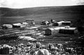
 Metula 1926
 -
 Metula 1937
 -
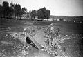
 British army camp
 -
 The bridge over Nahal Ayun after being blown up, 15 February 1948
 -
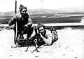 Members of Yiftach Brigade (which blew up the bridge)
 -
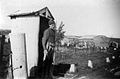 Metula camp after Yiftach Brigade takeover, 1948


Nahal Ayyun Bridge

The bridge over Nahal Ayun was built by the British in the years 1943–44. On June 17, 1946 (
State of Israel
In modern Israel, Metula is known as a wealthy town popular as a tourist destination, especially for Israeli schoolchildren on summer vacation.[19]
The "Good Fence" (1976–2000)
The
1985 attack

The Safari Disaster occurred during the South Lebanon conflict (1985–2000). On the afternoon of Sunday, March 10, 1985, a convoy of IDF soldiers in "Safari" model trucks were driving from Metula towards the Lebanese town of Marjayoun. Dozens of soldiers, having just attended Shabbat, were on their way back to duty. In accordance with regulations, one armed jeep in the forefront and two in the rear, and helmets and bullet-proof vests were worn. As they were crossing the narrow bridge over Nahal Ayyun at 13:45 a red Chevrolet pickup truck drove towards them. The soldiers of the first jeep noticed that the driver had friendly smile, and he was signaled to pull over to let the convoy pass. The first jeep and the first safari truck did so. At 13:50 the driver of the Chevrolet detonated a tremendous explosion which shattered windows in Metula itself. Twelve soldiers were killed and 14 wounded.[20]
2006 Lebanon War
During the 2006 Lebanon War, Metula became a temporary ghost town when its populace fled Hezbollah rocket fire. It was hit by 120 rockets during the war.[19]
Israel–Hamas war
In the midst of the Israel–Hamas war, Hezbollah targeted northern Israeli border communities with rockets and missiles, prompting the evacuation of several, including Metula. On October 17, a Hezbollah-launched anti-tank missile struck Metula, resulting in the injury of one civilian and two IDF reservists.[21]
On 19 December, Hezbollah fired artillery shells at the town.[22]
Area and population

The municipality governs a land area of 2,000
- 1948 – 172
- 1961 – 261
- 1972 – 333
- 1983 – 589
- 1995 – 942
- 2008 – 1,500
- 2022 – 1,740
Geography and climate

Metula lies in the northernmost point of Israel, next to the Lebanese border 6 kilometres (3.7 mi) at 520 m above sea level.
Winters are usually cold and wet, with an average annual rainfall of 900 mm, whereas summers are warm and dry. The river Nahal Ayoun has its sources in Lebanon, about seven kilometers north of Metula.
Notable residents
- Olga Danilov (born 1973), Israeli Olympic speed skater
- Alexandra Zaretsky (born 1987), Israeli ice dancer
- Roman Zaretsky (born 1983), Israeli ice dancer
Notes
- ^ "Regional Statistics". Israel Central Bureau of Statistics. Retrieved 21 March 2024.
- ^ Palmer, 1881, p. 30
- ^ Alexandre, 2008, Metulla
- ^ Jaffe, 2010, Metulla
- ^ a b Dauphin, 1998, p. 641
- ISBN 978-1-85828-248-0.
- ^ Buckingham, 1825, p. 407
- ^ Guérin, 1880, pp. 345–346
- ^ Conder and Kitchener, 1881, SWP I, p. 89
- ^ a b Morris, 2001, p. 55
- ^ a b c d e f Avneri, 1984, pp. 96-98
- ^ Marom, Roy (January 2021). "The Abu Hameds of Mulabbis: An Oral History of a Palestinian Village Depopulated in the Late Ottoman Period". British Journal of Middle Eastern Studies. 48: 2.
- ^ ISBN 978-0-19-822721-2.
- S2CID 144575833.
- ISBN 978-965-223-589-3.
- ^ a b c Biger, 2004, p. 134
- ^ Bentwich, 1919, p. 96
- ^ See municipality plaque at the site
- ^ a b Calm Returns to Israeli Border Town Two Years After War
- ^ "Israel in Mourning as 12 Killed in Suicide-truck Bombing Are Buried". 12 March 1985.
- ^ Fabian, Emanuel. "Metula missile attack injures 3; IDF kills Hezbollah cell trying to infiltrate border". www.timesofisrael.com. Retrieved 2023-10-22.
- ^ الدهيبي, جنى. "هل ينجح الغرب في سحب حزب الله من جنوب الليطاني؟". الجزيرة نت (in Arabic). Retrieved 2023-12-20.
Bibliography
- Alexandre, Yardenna (2008-12-30). "Metulla Final Report" (121). Hadashot Arkheologiyot – Excavations and Surveys in Israel.
{{cite journal}}: Cite journal requires|journal=(help) - Avneri, Arieh L. (1984). The Claim of Dispossession: Jewish Land-settlement and the Arabs, 1878-1948. Transaction Publishers. ISBN 0-87855-964-7.
- Bentwich, N. (1919). Palestine of the Jews: past, present and future. London: K. Paul, Trench, Trubner.
- Biger, Gideon (2004). The boundaries of modern Palestine, 1840-1947. Routledge. ISBN 978-0-7146-5654-0.
- Buckingham, J.S. (1825). Travels among the Arab Tribes inhabiting the countries east of Syria and Palestine…. London: Longman, Hurst, Rees, Orme, Brown and Green.
- Conder, C.R.; Kitchener, H.H. (1881). The Survey of Western Palestine: Memoirs of the Topography, Orography, Hydrography, and Archaeology. Vol. 1. London: Committee of the Palestine Exploration Fund.
- ISBN 0-860549-05-4.
- Guérin, V. (1880). Description Géographique Historique et Archéologique de la Palestine (in French). Vol. 3: Galilee, pt. 2. Paris: L'Imprimerie Nationale.
- Hadawi, S. (1970). Village Statistics of 1945: A Classification of Land and Area ownership in Palestine. Palestine Liberation Organization Research Center.
- Jaffe, Gilad Bezal'el (2010-02-28). "Metulla Final Report" (122). Hadashot Arkheologiyot – Excavations and Surveys in Israel.
{{cite journal}}: Cite journal requires|journal=(help) - Mills, E., ed. (1932). Census of Palestine 1931. Population of Villages, Towns and Administrative Areas. Jerusalem: Government of Palestine.
- ISBN 0-679-42120-3.
- Palmer, E.H. (1881). The Survey of Western Palestine: Arabic and English Name Lists Collected During the Survey by Lieutenants Conder and Kitchener, R. E. Transliterated and Explained by E.H. Palmer. Committee of the Palestine Exploration Fund.
External links
- Metula municipality
- Places To Visit in Metula (English)
- Canada Centre
- Israel Nature and National Parks Protection Authority, Eng+Heb
- Survey of Western Palestine, Map 2: IAA, Wikimedia commons
.svg)
| International | |
|---|---|
| National | |