
Miami Avenue
SR 854 in Miami Gardens | |
| Construction | |
|---|---|
| Inauguration | 1920 |
Miami Avenue is a 16.8-mile (27.0 km) main north–south street running through
Route description

The southern terminus is on South Bayshore Drive in the
It continues north through El Portal a short distance until it crosses North 90th Street and enters the village of
The road resumes north from Miami Gardens Drive, terminating at Ives Dairy Road.
Brickell
In Brickell, Miami Avenue is Brickell's main restaurant and nightlife avenue, with many bars, restaurants, and lounges, including the now-demolished Tobacco Road.
In 2022, Miami-Dade County commissioners and the City of Miami co-designated a stretch of South Miami Avenue (from Southeast 15th Road to Southeast 13th) as Alicia Cervera Way, honoring the Peruvian-American businesswoman and real estate figure.[3][4][5]
Major intersections
Miami Avenue is the dividing line between Northwest and Northeast streets. The entire route is in Miami-Dade County.
| Location | mi[1] | km | Destinations | Notes | |||
|---|---|---|---|---|---|---|---|
Miami | 0.0 | 0.0 | Mercy Way | ||||
| 0.8 | 1.3 | ||||||
| 2.3 | 3.7 | SR 90 ) | |||||
| 2.7 | 4.3 | Downtown Distributor (SR 970) | |||||
| 2.9 | 4.7 | SR 968 (Flagler Street) | Central Miami | ||||
| 5.4 | 8.7 | ||||||
| 5.5 | 8.9 | Exit 2A on I-195 | |||||
| 6.4 | 10.3 | ||||||
| 8.0 | 12.9 | ||||||
| Miami Shores | 9.5 | 15.3 | |||||
| | 10.5 | 16.9 | |||||
| North Miami | 10.9 | 17.5 | |||||
| 11.5 | 18.5 | ||||||
| North Miami Beach | 13.5 | 21.7 | To Palmetto Expressway | ||||
| 13.9 | 22.4 | North 173rd Street | |||||
| Golden Glades Interchange, gap in route | |||||||
| Miami Gardens | 0.0 | 0.0 | |||||
| 1.0 SR 854 | |||||||
| 1.000 mi = 1.609 km; 1.000 km = 0.621 mi | |||||||
See also
- Brickell Avenue
- Biscayne Boulevard
- Flagler Street
- Brickell
- Downtown Miami
Gallery
-
 Miami Avenue facing south as it crosses the Miami River into Brickell
 -
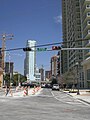 Miami Avenue facing north in Brickell
 -
 Mary Brickell Village on Miami Avenue


References
- ^ a b Google (May 17, 2019). "Miami Avenue" (Map). Google Maps. Google. Retrieved May 17, 2019.
- ^ a b Google (May 17, 2019). "Miami Avenue" (Map). Google Maps. Google. Retrieved May 17, 2019.
- ^ Bandell, Brian (2023-02-17). "Alicia Cervera Sr. named SFBJ's 2023 Lifetime Achievement Award honoree". www.bizjournals.com. Retrieved 2023-10-13.
- ^ Cela, Victoria (2022-04-25). "County commisioners co-designate part of S. Miami Ave. as 'Alicia Cervera Way' | Biscayne Bay Tribune#". Retrieved 2023-10-13.
- ^ "Honran a empresaria Alicia Cervera con calle en Miami-Dade". diariolasamericas.com (in Spanish). 2022-04-14. Retrieved 2023-10-13.
28°04′31″N 80°41′26″W / 28.0752843°N 80.6906824°W