
Mid-Atlantic (United States)
Mid-Atlantic | |
|---|---|
   .jpg)   .jpg)  Left to right from top: | |
| Largest city | New York |
| Area | |
| • Total | 191,299.86 sq mi (495,464.4 km2) |
| • Land | 174,468.45 sq mi (451,871.2 km2) |
| • Water | 16,831.41 sq mi (43,593.2 km2) 8.80% |
| Population | |
| • Total | 60,783,913 |
| • Density | 320/sq mi (120/km2) |
| GDP (nominal) | |
| • Q3 2022 | $5.233 trillion |
The Mid-Atlantic is a region of the United States located in the overlap between the Northeastern and Southeastern states of the United States. Its exact definition differs upon source, but the region typically includes Delaware, the District of Columbia, Maryland, New Jersey, New York, Pennsylvania, Virginia, and West Virginia[3] with other sources including or excluding other states or areas in the Northeast and Southeast.[3][4][5][6][7][8][9] The region has its origin in the Middle Colonies of the 18th century, its states being among the Thirteen Colonies of pre-revolutionary British America. As of the 2020 census, the region had a population of 60,783,913, representing slightly over 18% of the nation's population.
The Mid-Atlantic region played an instrumental and historic role in the nation's founding and the development of the nation. Each of the seven states were members of the Thirteen Colonies that sent delegates to the Second Continental Congress, which assembled in Philadelphia and unanimously adopted the Declaration of Independence, and formalized the Continental Army under George Washington's command during the American Revolutionary War. Following independence, the states again gathered in Philadelphia at the Constitutional Convention, in 1788, where they ratified the United States Constitution, which remains the oldest and longest-standing written and codified national constitution in force in the world.[10]
The Mid-Atlantic region was settled during the colonial era between the early 17th century and the conclusion of the American Revolutionary War in 1783 by European Americans of primarily Dutch, German, Swedish, English, and other Western European ethnicities. Religious pluralism and freedoms existed in the original Thirteen Colonies and were particularly prevalent in Province of Pennsylvania and the geographic region that ultimately broke from Pennsylvania to form the Delaware Colony. Among the 13 colonies, the Province of Maryland was the only colony with a substantial Catholic population.
Following the American Revolutionary War, the Mid-Atlantic region hosted each of the historic capitals of the United States. The nation's capital was constructed in Washington, D.C. in the late 18th century, and relocated there from Philadelphia in 1800.
In the early part of the 19th century, New York and Pennsylvania overtook Virginia as the nation's two most populous states, and the Mid-Atlantic region overtook
In the late 19th century, the region played a vital and historic role in the development of
The
The region is home to eight of the top 25 ranked universities in the nation: Cornell University in Ithaca, New York, Columbia University and NYU in New York City, Princeton University in Princeton, New Jersey, the University of Pennsylvania in Philadelphia, Carnegie Mellon University in Pittsburgh, Johns Hopkins University in Baltimore, Georgetown University in Washington, D.C., and the University of Virginia in Charlottesville, Virginia according to U.S. News & World Report Best Colleges Ranking.[12][13][14]
Composition
Definitions of the geographic components of the Mid-Atlantic region differ slightly among sources.[15] Generally speaking, the region is inclusive of the states and federal district of Delaware, the District of Columbia, Maryland, New Jersey, New York, Pennsylvania, Virginia, and West Virginia, with some additional sources including or excluding other areas in parts of the Northeast region and the South Atlantic states, for practical reasons.[3][4][5][6][7][8][9]
The United States Census Bureau defines the Mid-Atlantic as a sub-region of the Northeast and only includes New Jersey, New York, and Pennsylvania.[5] The Bureau of Labor Statistics excludes New York;[3] the Environmental Protection Agency excludes New York and New Jersey;[7] and the U.S. Department of Transportation - United States Maritime Administration includes North Carolina.[8] In 2004, the United States Geological Survey within the context of Ground-Water Vulnerability to Nitrate Contamination, defined the region as including Delaware, Maryland, Pennsylvania, Virginia, and Washington, D.C., and parts of New Jersey, New York, and North Carolina.[6]
West Virginia and Virginia are atypical of this region in a few ways. These states both primarily lie within the Southern American dialect region,[16] and the major religious tradition is largely Evangelical Christian, with 30% in Virginia and 39% in West Virginia identifying as evangelicals.[17] Although a few of West Virginia's eastern panhandle counties are considered part of the Washington metropolitan area, the major portion of the state is rural and there are no major or even large cities.[18]
-
![A USGS fact sheet on the Mid-Atlantic region's groundwater[19]](//upload.wikimedia.org/wikipedia/commons/thumb/4/4f/Mid-Atlantic_Region_location_map.gif/117px-Mid-Atlantic_Region_location_map.gif)
-
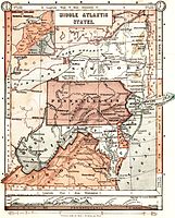 An 1897 map displaying a broad definition of the Mid-Atlantic region
 -
 An 1886 Harper's School Geography map showing the region, which excludes Virginia and West Virginia
 -
 The U.S. Census Bureau's geographic definition of the Mid-Atlantic includes three states, New Jersey, New York, and Pennsylvania
![A USGS fact sheet on the Mid-Atlantic region's groundwater[19]](/File:Mid-Atlantic_Region_location_map.gif)


History

Shipping and trade have been important to the Mid-Atlantic economy since the beginning of the colonial era. The explorer Giovanni da Verrazzano was the first European to see the region in 1524. Henry Hudson later extensively explored that region in 1611 and claimed it for the Dutch, who then created a fur-trading post in Albany in 1614. Jamestown, Virginia was the first permanent English colony in North America, it was established seven years earlier in 1607.
From early colonial times, the Mid-Atlantic region was settled by a wider range of European people than in New England or the South. The Dutch
The area that came to be known as the
While early settlers were mostly farmers, traders, and fishermen, the Mid-Atlantic states provided the young United States with heavy industry and served as the "melting pot" of new immigrants from Europe. Cities grew along major ports, shipping routes, and waterways, including New York City and Newark on opposite sides of the Hudson River, Philadelphia on the Delaware River, Allentown on the Lehigh River, and Baltimore on the Chesapeake Bay.
Major states, cities, and urban areas


Metropolitan areas
| MSA | 2020 Census | 2010 Census | |
|---|---|---|---|
| 1 | New York-Newark-Jersey City, NY-NJ-PA | 20,140,470 | 18,897,109 |
| 2 | Washington-Arlington-Alexandria, DC-VA-MD-WV | 6,385,162 | 5,649,540 |
| 3 | Philadelphia-Camden-Wilmington, PA-NJ-DE-MD | 6,245,051 | 5,965,343 |
| 4 | Baltimore-Columbia-Towson, MD | 2,844,510 | 2,710,489 |
| 5 | Pittsburgh, PA |
2,370,930 | 2,356,285 |
| 6 | Virginia Beach-Norfolk-Newport News, VA-NC | 1,799,674 | 1,713,954 |
| 7 | Richmond, VA | 1,314,434 | 1,186,501 |
| 8 | Buffalo-Cheektowaga, NY |
1,166,902 | 1,135,509 |
| 9 | Rochester, NY | 1,090,135 | 1,079,671 |
| 10 | Albany-Schenectady-Troy, NY |
899,262 | 870,716 |
| City | 2020 Census | Total area | |
|---|---|---|---|
| 1 | New York, NY | 8,804,190 | 472.43 sq mi |
| 2 | Philadelphia, PA | 1,603,797 | 142.70 sq mi |
| 3 | Washington, D.C. | 689,545 | 68.35 sq mi |
| 4 | Baltimore, MD | 585,708 | 92.05 sq mi |
| 5 | Virginia Beach, VA | 459,470 | 497.50 sq mi |
| 6 | Newark, NJ | 311,549 | 25.88 sq mi |
| 7 | Pittsburgh, PA | 302,971 | 58.35 sq mi |
| 8 | Jersey City, NJ |
292,449 | 21.03 sq mi |
| 9 | Buffalo, NY |
278,349 | 52.48 sq mi |
| 10 | Chesapeake, VA | 249,422 | 350.95 sq mi |
| Township | 2020 Census | |
|---|---|---|
| 1. | Hempstead, NY | 793,409 |
| 2. | Brookhaven, NY | 485,773 |
| 3. | Islip, NY | 339,938 |
| 4. | Oyster Bay, NY | 301,332 |
| 5. | N. Hempstead, NY | 237,639 |
| 6. | Babylon, NY | 218,223 |
| 7 | Huntington, NY | 204,127 |
| 8 | Ramapo, NY | 148,919 |
| 9 | Lakewood Township, NJ | 135,158 |
| 10. | Amherst, NY | 129,595 |
States and federal district
| State or federal district | 2020 Census | Total area | |
|---|---|---|---|
| 1 | New York | 20,201,249 | 54,555 sq mi |
| 2 | Pennsylvania | 13,002,700 | 46,055 sq mi |
| 3 | New Jersey | 9,288,994 | 8,722.58 sq mi |
| 4 | Virginia | 8,631,393 | 42,774.2 sq mi |
| 5 | Maryland | 6,177,224 | 12,407 sq mi |
| 6 | West Virginia | 1,793,716 | 24,230 sq mi |
| 7 | Delaware | 989,948 | 2,489 sq mi |
| 8 | District of Columbia | 689,545 | 68.35 sq mi |
| Census | Pop. | Note | %± |
|---|---|---|---|
| 1790 | 2,085,066 | — | |
| 1800 | 2,702,679 | 29.6% | |
| 1810 | 3,466,545 | 28.3% | |
| 1820 | 4,278,349 | 23.4% | |
| 1830 | 5,362,691 | 25.3% | |
| 1840 | 6,357,873 | 18.6% | |
| 1850 | 8,046,649 | 26.6% | |
| 1860 | 9,929,648 | 23.4% | |
| 1870 | 11,515,592 | 16.0% | |
| 1880 | 13,887,075 | 20.6% | |
| 1890 | 16,566,269 | 19.3% | |
| 1900 | 19,919,159 | 20.2% | |
| 1910 | 24,427,360 | 22.6% | |
| 1920 | 28,144,267 | 15.2% | |
| 1930 | 32,768,581 | 16.4% | |
| 1940 | 34,870,074 | 6.4% | |
| 1950 | 38,951,029 | 11.7% | |
| 1960 | 44,306,759 | 13.7% | |
| 1970 | 48,818,784 | 10.2% | |
| 1980 | 49,532,898 | 1.5% | |
| 1990 | 51,637,657 | 4.2% | |
| 2000 | 55,210,865 | 6.9% | |
| 2010 | 57,999,602 | 5.1% | |
| 2020 | 60,783,913 | 4.8% | |
| Source:1790–2020[21] | |||
State capitals and federal district
| Capital | 2020 Census | Total area | |
|---|---|---|---|
| 1 | Washington, D.C. | 689,545 | 68.35 sq mi |
| 2 | Richmond, Virginia | 226,610 | 62.57 sq mi |
| 3 | Albany, New York | 99,224 | 21.94 sq mi |
| 4 | Trenton, New Jersey | 90,871 | 8.20 sq mi |
| 5 | Harrisburg, Pennsylvania | 50,099 | 11.86 sq mi |
| 6 | Charleston, West Virginia | 48,864 | 32.64 sq mi |
| 7 | Annapolis, Maryland | 40,812 | 8.11 sq mi |
| 8 | Dover, Delaware | 39,403 | 23.97 sq mi |
Note: The Mid-Atlantic region is also home to the nation's capital, Washington, D.C.
In presidential elections
| Parties | |||||||||
| Nonpartisan | Federalist | Democratic-Republican | National Republican | Democratic | Whig | Know Nothing | Republican | Constitutional Union | Progressive
|
- Bold denotes election winner.
Culture
Sports
The Mid-Atlantic is home to 33 professional sports franchises in the five major leagues and the two most prominent women's professional leagues:
NFL |
NHL |
MLB |
NBA |
MLS |
WNBA |
NWSL | |
|---|---|---|---|---|---|---|---|
| New York/New Jersey | Giants Jets |
Devils Islanders Rangers |
Mets Yankees |
Knicks Nets |
NYC FC Red Bulls |
Liberty | Gotham FC
|
| Washington | Commanders | Capitals | Nationals | Wizards | United | Mystics | Spirit |
| Philadelphia | Eagles | Flyers | Phillies | 76ers | Union | ||
| Pittsburgh | Steelers | Penguins | Pirates | ||||
| Baltimore | Ravens | Orioles | |||||
| Buffalo | Bills | Sabres |
Notable golf tournaments in the Mid-Atlantic include the
Two high-level professional tennis tournaments are held in the region. The
Notable motorsports tracks include
Economy
With a GDP nominal of over $5.2 trillion, the Mid-Atlantic economy would be third-largest in the world if calculated separately, only behind the remaining United States and China and nearly $1 trillion larger than next place Japan. This economic prosperity is buoyed by a significant financial services and banking sector, healthcare and chemicals industry, and telecommunications and entertainment conglomerates.
According to the Global Financial Centres Index,[22] the Mid-Atlantic region is home to the leading financial center in the world (New York) at #1, with Washington also present at #15.
Notable companies (over $100 billion market cap) headquartered in the region include:
| Company | Headquarters | Market cap ($ billions) | Global rank |
|---|---|---|---|
| Chase | New York, New York | $447.91 | 13 |
| Johnson and Johnson | New Brunswick, New Jersey | $430.06 | 15 |
| Mastercard | Harrison, New York | $364.48 | 22 |
| Pfizer | New York, New York | $272.39 | 29 |
| PepsiCo | Harrison, New York | $232.01 | 40 |
Verizon Communications
|
New York, New York | $225.96 | 45 |
| Comcast-NBC | Philadelphia, Pennsylvania | $211.42 | 50 |
| Merck | Kenilworth, New Jersey | $192.90 | 60 |
| Danaher | Washington, District of Columbia | $190.74 | 61 |
| Morgan Stanley | New York, New York | $169.08 | 73 |
| American Express | New York, New York | $147.98 | 89 |
| Bristol Myers Squibb | New York, New York | $147.23 | 91 |
| Citigroup | New York, New York | $127.27 | 105 |
| Goldman Sachs | New York, New York | $115.43 | 118 |
| BlackRock | New York, New York | $114.67 | 120 |
| International Business Machines | North Castle, New York | $111.45 | 124 |
| Estee Lauder | New York, New York | $108.67 | 130 |
| Lockheed Martin | Bethesda, Maryland | $105.24 | 137 |
See also
References
- ^ "2020 Census Apportionment Results". The United States Census Bureau.
- ^ "GDP by State | U.S. Bureau of Economic Analysis (BEA)" (PDF).
- ^ a b c d "Mid-Atlantic Home : Mid–Atlantic Information Office : U.S. Bureau of Labor Statistics". www.bls.gov. Retrieved January 14, 2024.
- ^ a b Schultz, Alex. "7 Beautiful Mid-Atlantic States". Touropia. Retrieved January 14, 2024.
- ^ a b c "Census Regions and Divisions of the United States" (PDF). United States Department of Commerce, Economics and Statistics Administration, United States Census Bureau, Geography Division. Archived from the original (PDF) on September 21, 2013.
- ^ a b c Earl A. Greene et al. "Ground-Water Vulnerability to Nitrate Contamination in the Mid-Atlantic Region". Archived November 17, 2017, at the Wayback Machine USGS Fact Sheet FS 2004-3067. 2005. Retrieved April 25, 2013. Note: Although the locator map appears to exclude part of northwestern Pennsylvania, other more detailed maps in this article include all of the state. Often, when discussing climate, southern Connecticut is included with the Middle Atlantic.
- ^ a b c EPA Region 3 (Mid-Atlantic) | Serving Delaware, District of Columbia, Maryland, Pennsylvania, Virginia, West Virginia and 7 federally recognized tribes. U.S. Environmental Protection Agency (EPA). (n.d.). https://www.epa.gov/aboutepa/epa-region-3-mid-atlantic
- ^ a b c Mid-Atlantic Gateway (Washington, DC). Mid-Atlantic Gateway (Washington, DC) | MARAD. (n.d.). https://www.maritime.dot.gov/about-us/gateway-offices/mid-atlantic-gateway-office-washington-dc
- ^ a b U.S. Department of Defense - Office of Small Business Programs. "Mid-Atlantic Regional Council". business.defense.gov. Retrieved January 14, 2024.
{{cite web}}:|last=has generic name (help) - ^ Goodlatte says U.S. has the oldest working national constitution, Politifact Virginia website, September 22, 2014.
- ^ "United States". Encyclopædia Britannica. 2009. Retrieved April 9, 2009.
- ^ "National University Rankings". U.S. News & World Report. Retrieved February 21, 2022.
- ^ "Best Global Universities Rankings". U.S. News & World Report. Retrieved February 21, 2022.
- ^ "U.S. News & World Report Best Colleges Ranking". U.S. News & World Report. Retrieved January 14, 2024.
- ^ "Merriam-Webster". Merriam-webster.com. Retrieved August 30, 2017.
- ^ Labov, William, Sharon Ash and Charles Boberg, Atlas of North American English: Phonetics, Phonology and Sound Change, Mouton de Gruyter, 2005 Southern Regional Map Archived June 5, 2017, at the Wayback Machine
- ^ "Religious Landscape Study". Religions.pewforum.org. May 11, 2015. Retrieved November 2, 2017.
- ^ "U.S. Census 2000 Report" (PDF). Census.gov. Retrieved November 2, 2017.
- ^ Earl A. Greene et al. "Ground-Water Vulnerability to Nitrate Contamination in the Mid-Atlantic Region" Archived 2017-11-17 at the Wayback Machine. USGS Fact Sheet FS 2004-3067. 2005. Retrieved 25 April 2013. Note: Although the locator map appears to exclude part of northwestern Pennsylvania, other more detailed maps in this article include all of the state.
- ^ "The Demographic Statistical Atlas of the United States - Statistical Atlas". statisticalatlas.com. Retrieved September 18, 2023.
- ^ "Historical Population Change Data (1910–2020)". Census.gov. United States Census Bureau. Archived from the original on April 29, 2021. Retrieved May 1, 2021.
- ^ "The Global Financial Centres Index 30" (PDF). Retrieved February 21, 2022.
Bibliography
- Bodle, Wayne, "The Mid-Atlantic and the American Revolution", Pennsylvania History 82 (Summer 2015), 282–99.
- Heineman, Kenneth J., "The Only Things You Will Find in the Middle of the Road are Double Yellow Lines, Dead Frogs, and Electoral Leverage: Mid-Atlantic Political Culture and Influence across the Centuries", Pennsylvania History, 82 (Summer 2015), 300–13.
- Landsman, Ned C. Crossroads of Empire: The Middle Colonies in British North America (2010)
- Longhurst, James. "'Typically American': Trends in the History of Environmental Politics and Policy in the Mid-Atlantic Region". Pennsylvania History: A Journal of Mid-Atlantic Studies 79.4 (2012): 409–427.
- Magoc, Chris J., "In Search of a Useable—and Hopeful—Environmental Narrative in the Mid-Atlantic", Pennsylvania History, 82 (Summer 2015), 314–28.
- Mancall, Peter C., Joshua L. Rosenbloom, and Thomas Weiss. "Exports from the Colonies and States of the Middle Atlantic Region 1720–1800". Research in Economic History 29 (2013): 257–305.
- Marzec, Robert. The Mid-Atlantic Region: The Greenwood Encyclopedia of American Regional Cultures (2004)
- Richter, Daniel K, "Mid-Atlantic Colonies, R.I.P.", Pennsylvania History, 82 (Summer 2015), 257–81.
- Rosenbloom, Joshua L., and Thomas Weiss. "Economic growth in the Mid-Atlantic region: Conjectural estimates for 1720 to 1800". Explorations in Economic History 51 (2014): 41–59.