
Midcontinent Rift System

The Midcontinent Rift System (MRS) or Keweenawan Rift is a 2,000 km (1,200 mi) long geological
Formation and failure

The rock formations created by the rift included
The southwest and southeast extensions represent two arms of the triple junction while a third failed arm extends north into Ontario as the Nipigon Embayment.[3][5] This failed arm includes Lake Nipigon, Ontario.
The rift system may have been the result of extensional forces behind the continental collision of the
The rift today

Lake Superior occupies a basin created by the rift.[3] Near the present lake, rocks produced by the rift can be seen on the surface of Isle Royale and the Keweenaw Peninsula of the Upper Peninsula of Michigan,[9] northwest Wisconsin,[10] and on the North Shore of Superior in Minnesota and Ontario.[4] Similar rocks are exposed as far south as Interstate Park near Saint Paul, Minnesota,[3][11][12] but elsewhere the rift is buried beneath more recent sedimentary rocks up to 9 km (6 mi) thick.[13] Where buried, the rift has been mapped by gravity anomalies (its dense basaltic rock increases gravity locally),[14]
A slightly older but possibly related geologic feature is the 2,700,000 km2 (1,000,000 sq mi) Mackenzie Large Igneous Province in Canada, which extends from the Arctic in Nunavut to near the Great Lakes in Northwestern Ontario.[16]
Natural resources

The Proterozoic Nonesuch Shale formation in the Keweenawan Rift contains enough organic carbon (greater than 0.5%) to be considered a potential source rock for petroleum. Oil identified as Precambrian has been found seeping out of the Nonesuch Shale in the White Pine mine in Michigan.[18] A few deep wells were drilled to explore for oil and gas in rift rocks as far southwest as Kansas. No oil and gas were found, but the explorations did make some deep rock samples available.[13] These include two "dry holes" drilled by Amoco: a 7,238 ft (2,206 m) well in Alger County, Michigan in 1987 and 1988, and one in Bayfield County, Wisconsin to a depth of 4,966 ft (1,514 m) in 1992.[19] In 1987 Amoco also drilled a 17,851 ft (5,441 m) dry hole that penetrated rift sediments in Iowa.[20]
The Michigan
White hydrogen
Gallery
-
 Geological map of North America showing the Midcontinent Rift in white, here labeled Keweenawan Rift. Lake Superior now occupies the apex of the rift; the section to its north marked "SUPERIOR" is the Superior Craton
 -

-
 Eroded volcanic strata at Isle Royale in Michigan
 -
 A mafic sill at Thunder Bay, Ontario
 -
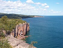 Cliffs at Palisade Head and Shovel Point in Minnesota
 -
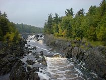 Saint Louis River in Jay Cooke State Park in Minnesota
 -
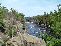 Dalles of theInterstate State Park, Minnesota-Wisconsin


See also
- Coldwell Complex – Landform in Thunder Bay district, Ontario
- Geology of Ontario
- Mamainse Point Formation
- Volcanology of Canada– Volcanic activity in Canada
- Volcanology of Eastern Canada– volcanic areas and lava formations in Eastern Canada
References
- . Retrieved 1 May 2018.
- ^ a b "Middle Proterozoic and The Mid-continent Rift". Minnesota's Rocks and Waters. Winona State University. Retrieved 13 April 2008.(Powerpoint presentation)
- ^ hdl:1808/104. Retrieved 10 June 2007.
- ^ ISBN 978-0-8166-0953-6.
- ^ Kean, William F. (24 November 2000). "Keweenawan Rift System". Field Trips, Northern Wisconsin and Upper Michigan. University of Wisconsin-Milwaukee. Archived from the original on 6 July 2008. Retrieved 8 June 2007.
{{cite web}}: CS1 maint: bot: original URL status unknown (link) - ^ . (Abstract)
- ^ )
- Bibcode:2006AGUFM.T42A..06S. Abstract #T42A-06.
- ^ a b Huber, Norman King (1975). "The story of Isle Royale National Park". Bulletin 1309. United States Geological Survey.
- ^ Anderson, Raymond R. (25 November 2014). "Introduction to the Midcontinental Rift". Iowa Department of Natural Resources Geological Survey. Archived from the original on 4 January 2019. Retrieved 27 May 2016.
- ^ Jol, Harry M. (2006). "Interstate State Park, A Brief Geologic History". University of Wisconsin at Eau Claire. Archived from the original on 15 December 2012.
- ^ Interstate State Park Management Plan, Minnesota Department of Natural Resources Division of Parks and Trails] (2009), p. 26.
- ^ a b Palacas, James G. (1995). "Superior Province (051)" (PDF). National Oil and Gas Assessment. United States Geological Survey. Retrieved 10 June 2007.
- hdl:11299/60081.
- ^ Hinze, W.; Kellogg, D.; Merritt, D. (1971). "Gravity and Aeromagnetic Anomaly Maps of the Southern Peninsula of Michigan" (PDF). Report of Investigation 14. Michigan State Geological Survey.
- ISBN 978-0-309-02928-5.)
{{cite book}}: CS1 maint: multiple names: authors list (link - ^ Kucks, Robert P.; Hill, Patricia L. (2005). "Iowa magnetic and gravity maps and data". U.S. Geological Survey. Retrieved 3 September 2009.
- ^ J.A. Seglund, "Midcontinent rift continues to show promise as petroleum prospect," Oil and Gas Journal, 15 May 1989, p.55-58.
- ^ Albert B. Dickas, Results of the Middle Proterozoic Midcontinent rift frontier play along Lake Superior's south shore, Oil & Gas Journal, 18 September 1995, pp. 80–82.
- ^ "Exploring the Midcontinent Rift". Iowa Geological Survey Resource Information Fact Sheet 2006-2.
- ^ Kraker, Dan (2 December 2013). "FAQ: Everything you need to know about PolyMet". Retrieved 10 December 2013.
- ^ Jira, Mark; David Southwick. "Mineral potential and geology of the Duluth Complex". Mineral Potential and Geology of Minnesota. Minnesota Geological Survey, University of Minnesota. Retrieved 13 April 2008.
- ^ Kraker, Dan (5 December 2013). "PolyMet's copper-nickel mine rekindles decades-old environmental debate". Minnesota Public Radio. Retrieved 10 December 2013.
- ^ "The Potential for Geologic Hydrogen for Next-Generation Energy | U.S. Geological Survey".
External links
- "Mineral Deposits of the Midcontinent Rift System". United States Geological Survey Mineral Resources Program, Eastern Mineral and Environmental Resources Science Center. A detailed and well-illustrated resource focusing on the mineral resources of the Midcontinent Rift and its geologic history.
- Stein, Seth et al. (2016) "New Insights into North America’s Midcontinent Rift". Eos, 97, https://doi.org/10.1029/2016EO056659.