
Mishmi Hills
| Mishmi Hills | |
|---|---|
 Snow capped Tops of Mishmi Hills, view from Mayodia Pass, Hunli town at the bottom left | |
| Highest point | |
| Coordinates | 29°6′N 96°22′E / 29.100°N 96.367°E |
| Geography | |
 Mishmi Hills Location of the Mishmi Hills  Mishmi Hills Mishmi Hills (India)  Mishmi Hills Mishmi Hills (Tibet) | |
| Country | India |
| State | Arunachal Pradesh |
The Mishmi Hills are located at the northeastern tip of
These hills occur at the junction of Northeastern Himalaya and Indo-Burma ranges. The Himalayan arc takes a sharp turn and meets Indo-Burma ranges. The rocks of eastern lesser Himalaya and the central crystallines appear to be largely attenuated and truncated in Mishmi Hills.[2]
Geography
Geomorphically, the Mishmi Hills are divided into 2 sections – the flood plains of tributaries of

Highest point of the Mishmi Hills
- Lohitang Peak at 5,256.25 metres (17,244.9 ft). Lohitang means The Blood Red coloured Mountain. It is the Last point of Eastern India located at 28°21′N 97°38′E / 28.350°N 97.633°E in Arunachal Pradesh
- Lama Peak at 5,184 metres (17,008 ft). It is the 2nd highest point of the Mishmi Hills located at 29°35′N 96°15′E / 29.583°N 96.250°E in Arunachal Pradesh
- Arunachal Peak at 5,148 metres (16,890 ft). It is the 3rd highest point of the Mishmi Hills & The Easternmost point of India located at 28°02′N 97°44′E / 28.033°N 97.733°E in Arunachal Pradesh
Administration
In India, the Mishmi Hills were declared as a district after its bifurcation of Sadiya Frontier Tract in 1948. Again in 1951, the plains area were transferred to the administrative jurisdiction of Assam.[5] In 1952, the headquarters was shifted from Sadiya to Tezu. When the North-East Frontier Agency (NEFA) formed in 1954, Mishmi Hills District became Lohit Frontier Division.
In China, the western parts of the Hills fall under the administration of
Flora and fauna
The Mishmi Hills experience heavy rainfall with pre-monsoon showers from March. The humidity and rainfall is about 90%. There are about 6000 plant species, 100 mammal species and about 700 bird species. There are also a large number of butterflies and other insects. Temperate conifers, sub-alpine woody shrubs, alpine meadows, bamboos and grasslands are found in this region. Tiger, common leopard, clouded leopard, snow leopard, golden cat, jungle cat, marbled cat and the leopard cat are found. The endangered red panda is seen in the northern reaches and the hoolock gibbon is in the lower areas. A new subspecies of hoolock gibbon has been described from this area which has been named as Mishmi Hills hoolock H. h. mishmiensis.[6] A new giant flying squirrel named as Mishmi Hills giant flying squirrel has also been described from the region.[7]
One of the most unusual ungulates found here is the Mishmi takin. Himalayan serow, musk deer and the Himalayan black bear are also found.[3]
There are about 680 bird species.
The major part of Dihang-Dibang Biosphere Reserve and the whole of Dibang Wildlife Sanctuary falls within the area of Mishmi Hills [9]
Climate
Temperatures ranges from below 5 °C in winter to 38 °C in summer.
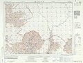
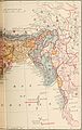
Maps
-
 1936
1936 -
 1954
1954 -
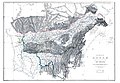 1891
1891 -
 1891
1891 -
 1960
1960


References
- ISBN 978-81-7099-788-7. Retrieved 27 July 2012.
- ISBN 978-1-4020-8179-8. Retrieved 28 July 2012.
- ^ a b c "Mishmi Hills, Arunachal Pradesh". Archived from the original on 30 January 2017. Retrieved 27 July 2012.
- ISBN 978-81-86030-89-9. Retrieved 27 July 2012.
- ISBN 978-81-313-0379-5. Retrieved 28 July 2012.
- ^ .A. U. Choudhury (2013). Description of a new subspecies of hoolock gibbon Hoolock hoolock from North East India. The Newsletter & Journal of the Rhino Foundation for nat. in NE India 9: 49–59.
- ^ .A. U. Choudhury (2009). One more new species of giant flying squirrel of the genus Petaurista Link, 1795 from Arunachal Pradesh in north-east India. Newsletter & J. Rhino Foundation NE India 8: 27-35, plates".
- ^ "Mishmi Hills and adjoining areas Checklist of Birds". Archived from the original on 23 July 2017.
- ISBN 978-3-8433-6088-3.
Further reading
- Cooper, Thomas Thornville (1873). The Mishmee Hills: An Account of a Journey Made in an Attempt to Penetrate Thibet from Assam to Open New Routes for Commerce. H.S. King & Company.