
Mitcham
Mitcham is an area within the
Amenities include Mitcham Library and Mitcham Cricket Green. Nearby major districts are Croydon, Sutton, Streatham, Brixton and Merton. Mitcham, most broadly defined, had a population of 63,393 in 2011, formed from six wards including Pollards Hill.[2]
Location
Mitcham is in the east of the London Borough of Merton. Mitcham is close to Streatham, Croydon, Norbury, Morden, Sutton, Wimbledon, and Tooting. The River Wandle bounds the town to the southwest.[3] The original village lies in the west. Mitcham Common takes up the greater part of the boundary and the area to the south part of the CR4 postcode is in the area of Pollards Hill. Some of the area which includes Mitcham Common and parts of Mitcham Junction are in the CR0 postcode area.
History
.jpg)

The
What became the parish lands could have hosted the
The Domesday Book records Mitcham as Michelham. It was held partly by the Canons of
During her reign
When industrialisation occurred, Mitcham quickly grew to become a town and most of the farms were swallowed up in the expansion. Remnants of this farming history today include: Mitcham Common itself; Arthur's Pond on the corner of Watney's Road and Commonside East, and named for a local farmer; Alfred Mizen School (Garden Primary School), named after a local nurseryman charitable towards the burgeoning town; and the road New Barnes Avenue, replacing part of New Barn(e)s Farm.

Many
Mitcham was industrialised first along the banks of the Wandle, where
Activity along the Wandle led to the building of the
In 1829 Miss Mary Tate donated land and money to build almshouses on the site of the former Tate family home in Cricket Green. The buildings were designed in a Tudor style by John Butcher and established to accommodate twelve poor widows or spinsters of the parish. Miss Tate was the only surviving member of the Tate family, who had lived from about 1700 in a large mansion on the site of the almshouses.[7][8] The gardens at the rear of the property were originally provided for the use of residents, but later informally rented out as allotments.[9]
Mitcham became a borough, within a two-tier council system, on 19 September 1934 with the charter of incorporation being presented to the 84-year-old mayor, R.M. Chart, by the
| 19th Century | 20th Century | ||
|---|---|---|---|
| 1801 | 3,466 | 1901 | 14,903 |
| 1811 | 4,175 | 1911 | 29,606 |
| 1821 | 4,453 | 1921 | 35,119 |
| 1831 | 4,387 | 1931 | 56,859 |
| 1841 | 4,532 | 1941¹ | war |
| 1851 | 4,641 | 1951 | 67,269 |
| 1861 | 5,078 | 1961 | 63,690 |
| 1871 | 6,498 | 1971 | 60,608 |
| 1881 | 8,960 | 1981 | 57,158 |
| 1891 | 12,127 | 1991² | n/a |
| |||
| source: UK census | |||
Social housing schemes in the 1930s included New Close, aimed at housing people made homeless by a factory explosion in 1933 [citation needed] and Sunshine Way, for housing the poor from inner London.[11] This industry made Mitcham a target for German bombing during World War II. During this time Mitcham also returned to its agricultural roots, with Mitcham Common being farmed to help with the war effort.[citation needed]
From 1929 the electronics company Mullard had a factory on New Road.[citation needed]
Postwar, the areas of
The ground is also notable for having a road separate the pavilion from the pitch.[12] Local folklore claims Mitcham has the oldest fair in England, believing it to have been granted a charter by Queen Elizabeth I, a claim never proven.
- Literature
Nimrod, sporting writer of the early 19th century, advocated against the grazing on grass of racehorses. He finds a very fast donkey chaise, investigates the donkey's owner and finds it is a Mitcham blacksmith, who never turns out the donkey in summer onto Mitcham Common but keeps it fed with oats and beans as if a hunter racing horse.[13]
Mitcham appears in local variants of mildly vulgar rhymes of 18th and 19th centuries, all beginning with:
One variant ends with "Mitcham for a thief", another "
Open spaces

Mitcham is home to a large area (460 acres) of South London's open green space in the form of Mitcham Common, studded with a few ponds and buildings.
The buildings comprising the Windmill Trading Estate have existed in one form or another since 1782. The Mill House Ecology Centre and the Harvester (formerly the Mill House Pub) are located near the site of an old windmill, the remnants of which still exist.
The Seven Islands pond is the largest of all the ponds, created following
Notable buildings
-
 Eagle House, Mitcham
 -
 Old Mitcham Station
 -
 Mitcham Library, London Rd
 -
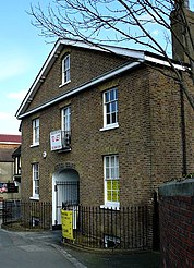
 Elm Lodge, Cricket Green
 -
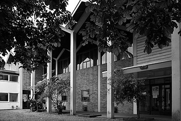 Mitcham Methodist Church
 -
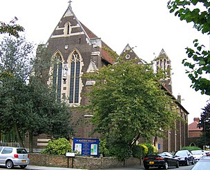 St Barnabas Church
 -
 The White House, Mitcham
 -
 The Burn Bullock
 -
 The White Hart Public House
 -


.jpg)


.jpg)
.jpg)
- The Canons. House originally built in 1680; it was the home of the family Cranmer until it was sold to the local council in 1939. The name originates from an Augustinian priory that was given this site in the 12th Century. The pond next to which it is located and the dovecote both predate the house.[16]
- Eagle House, built in 1705. Eagle House is a Queen Anne house built in the Dutch style on land formerly owned by Sir Walter Raleigh. It is on London Road, Mitcham, the grounds forming a triangle bounded by London Road, Bond Road and Western Road. The building was commissioned by the marranodoctor Fernando Mendes (1647–1724), former physician to King Charles II.
- Mitcham Common Windmill, a post mill dating from 1806.
- Old Mitcham Station, on the Surrey Iron Railway route. Now called Station Court, the building was a former merchant's home and is possibly the oldest station in the world.
- The Tate Almshouses, built in 1829 to provide for the poor by Mary Tate.
- The Watermead Fishing Cottages.
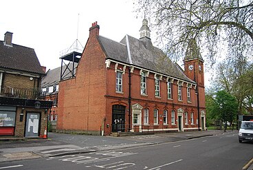
- Mitcham Vestry Hall, the annex of which now houses the Wandle Industrial Museum.
- Mitcham Public Library, built in 1933.
- Elm Lodge, 1808. This listed Sir William Nicholson. The curved canopy over the entrance door is a typical feature of this period.[citation needed]
- Mitcham Court. The centre portion, first known as Elm Court, was built in 1840, the wings later. Caesar Czarnikow, a sugar merchant, lived here ca. 1865–86 and presented the village with a new horse-drawn fire engine. Sir Harry Mallaby-Deeley, M.P., conveyed the house to the borough in the mid-1930s. The Ionic columned porch and the ironwork on the ground floor windows are notable features.
- Renshaw's factory, a marzipan factory, founded in 1898 in the City and thus one of the earliest in the country, which came to Mitcham in 1924.[citation needed] It was on Locks Lane until 1991, when the company moved its operations to Liverpool. The factory was featured in three 1950s British Pathé News shorts. The building has lent its name to the area where it stood, Renshaw Corner.
- Poulters Park, Home to Mitcham Rugby Union Football Club
- Imperial Fields, Tooting & Mitcham United F.C.'s home ground.
- Mitcham Methodist Church was designed by the architect Edward Mills (1915–1998), and built in 1958–9. Regarded as the best surviving work by the most successful Nonconformist architect of the period. A radical and inspiring building that was forwarded by the 20th Century Society for listing as it was under threat. Grade II listed on 5 March 2010.[17]
- St Barnabas church, Gorringe Park Avenue, Mitcham. Built in the gothic style, on 17 May 1913 the foundation stone of the church building was laid, and on 14 November 1914 the church was consecrated – by the bishop of Southwark. The architect was HP Burke-Downing. The building is still in use as an Anglican church. Both the church itself and the adjacent parish hall are Grade II listed.
- The White House, Mitcham on which the wall plaque says: "This 18th Century house was renovated in the Regency style in 1826 by Dr. A.C. Bartley, a village doctor, whose daughter wrote reminiscences of old Mitcham. The house remained in his family until 1919. Fluted Greek Doric columns support a slightly altered porch with a bowed front." It is Grade II listed.[18]
- The Burn Bullock Public House, London Road, Mitcham is a three-storey Grade II listed building originally called the King's Head Hotel. The front of the building dates from the 18th century whilst its wing dates from the 16th and 17th centuries.[19] It is named after a well known, former cricket player from the locality.[20][12]
- The White Hart public house is Mitcham's earliest recorded inn, rebuilt in 1749–50 after serious fire damage. The central porch, with frieze and balustrade, is supported by four Tuscan columns. Stagecoaches used to start from a yard at the rear. It is Grade II listed. It is located in London Road, opposite Cricket Green.[21]
Notable people
- Ramz (rapper) - singer, rapper[22]
- John Donne – Jacobean poet and churchman[23]
- James Chuter Ede – politician, MP for Mitcham 1923, resident till 1937, later Home Secretary[24]
- Michael Fielding and Noel Fielding – The Mighty Boosh comedians and brothers[25]
- Mike Fillery – Association football[26]
- David Gibson – cricketer[27]
- Florence Harmer – historian[28]
- opera singer[29]
- M.I.A. – singer, songwriter and rapper[30]
- Peter D. Mitchell — Nobel prizewinner, born in Mitcham in 1920[31]
- Slick Rick – East coast Rapper, born in Surrey, moved to USA aged 11[32]
- Alex Stepney – former Manchester United footballer and 1968 European Cup winner[33]
- Herbert Strudwick – cricket wicket-keeper[34]
- William Allison White – recipient of the Victoria Cross[35]
- Faryadi Sarwar Zardad – Afghan warlord; lived in Mitcham for a time, later convicted and imprisoned for war crimes[36]
Demography and economics
- Mitcham and Morden (Westminster Parliamentary Constituency)
- Population – 103,298[37]
- Ethnic Group[38]
British – 40,608, Irish – 1,840, Gypsy or Irish Traveller – 161, Other White – 12,899
White and Black Caribbean – 1,862, White and Black African – 856, White and Asian – 1,163, Other Mixed – 1,444
Indian – 4,536, Pakistani – 5,054, Bangladeshi – 1,484, Chinese – 1,169, Other Asian – 10,194
- Black/African/Caribbean
African – 9,036, Caribbean – 7,029, Other Black – 1,912
- Other Ethnic Group
Arab – 670, Other ethnic group – 1,381
- Religion[39]
Buddhist – 862, Sikh – 252, Jewish – 147, Other Religion – 362
- Gender[40]
- Female: 52,237
- Male: 51,061
| By property type | Number of sales last 12 months | Average price achieved last 12 months | Average price change per square foot |
|---|---|---|---|
| Detached | 5 | £525,404 | –20.9% |
| Semi-detached | 46 | £531,304 | 6.5% |
| Terraced | 279 | £478,749 | 3.3% |
| Flat/Apartment | 212 | £276,956 | 4.9% |
Transport and locale

Mitcham is served by two railway stations:
Trains on the Thameslink route from Central London continue on via the
with a change at Croydon.Bus
Bus services operated by
Coach
National Express services 028 London Victoria to Eastbourne, 025 London Victoria to Brighton and Worthing via Gatwick Airport, 026 London Victoria to Bognor Regis and A3 London Victoria to Gatwick Airport hourly shuttle all stop at Mitcham (Downe Road/Mitcham Library bus stop)[45]
Neighbouring areas | ||||||||||||||||
|---|---|---|---|---|---|---|---|---|---|---|---|---|---|---|---|---|
| ||||||||||||||||
Footnotes
- "Merry Making at Mitcham". Wayback Machine. The University of Sheffield's National Fairground Archive. Archived from the original on 21 December 2004.
- "Making Merton". Merton Council. Archived from the original on 26 April 2009.
- "A Brief History of Merton by John Precedo: Part 1 – Romans to the Norman Conquest". Wayback Machine. Tooting Community Website. Archived from the original on 13 April 2005.
- Eric Norman Montague (1976). The 'Canons' Mitcham. Merton Historical Society. ISBN 0-9501488-3-0.
- Eric Norman Montague (2001). North Mitcham. Merton Historical Society. ISBN 1-903899-07-9.
- Eric Norman Montague (1996). The Historic River Wandle: Phipps Bridge to Morden Hall. Merton Historical Society. ISBN 0-905174-25-9.
References
- ^ Mitcham is made up of 6 wards in the London Borough of Merton: Cricket Green, Figge's Marsh, Graveney, Lavender Fields, Longthornton, and Pollards Hill."2011 Census Ward Population Estimates | London DataStore". Archived from the original on 22 February 2014. Retrieved 9 June 2014.
- ^ "2011 Census Ward Population Estimates | London DataStore". Archived from the original on 22 February 2014. Retrieved 9 June 2014.
- ^ Ordnance Survey
- ^ "Surrey". The Domesday Book online – Surrey.
- ^ "Open Domesday: Mitcham". Retrieved 30 October 2022.
- ^ "Potter and Moore – An Introduction". Potter & Moore.
- ^ "Mary Tate Almshouses – Merton Memories Photographic Archive". photoarchive.merton.gov.uk. Retrieved 13 June 2019.
- ^ MISS TATE'S ALMSHOUSES, MITCHAM.
- ^ "Mary Tate Almshouses". www.londongardensonline.org.uk. Retrieved 13 June 2019.
- ^ Daily Mirror page 13, 19 September 1934
- ^ "New cottages by the church army". Church Times. 13 November 1936. Retrieved 16 November 2022.
- ^ a b c Siddique, Haroon (19 August 2018). "World's oldest village cricket green under threat from developers, club says". The Guardian. Retrieved 19 August 2018.
- ^ Pierce Egan, Pierce Egan's Anecdotes (original and Selected) of the Turf, the Chase, the Ring, and the Stage, Knight & Lacey, 1827, at page 57
- ^ "Chapter XIV: Local Allusions to Women". sacred-texts.com. Retrieved 5 December 2013.
- ^ wandlevalleypark.co.uk
- ^ "The Canons, Mitcham: Dovecote – Merton Memories Photographic Archive". photoarchive.merton.gov.uk. Retrieved 26 January 2016.
- ^ "Mitcham Methodist Church, exterior (E. Mills)". Flickr. 8 April 2010.
- ^ Historic England
- ^ "British Listed Buildings: Burn Bullock Public House, Merton". britishlistedbuildings.co.uk.
- ^ "Burn Bullock, Mitcham, Surrey". ukpubfinder.com.
- ^ Mitcham History Notes
- ^ Amarudontv (26 December 2017), Ramz [Interview] Overcoming Exclusion From Secondary School And Growing Up In South London, retrieved 3 January 2018
- doi:10.1093/ref:odnb/7819. (Subscription or UK public library membershiprequired.)
- ^ 'Lady Griffith-Boscawen cries over Mitcham result', Daily Graphic (4 March 1923), and other newspaper articles
- ^ Rumbelow, Helen (28 November 2009). "The Mighty Boosh's Noel Fielding says that 'Kids are frightened of me'". The Sunday Times. London. Retrieved 19 October 2010.
- ^ Mitcham at Post War English & Scottish Football League A–Z Player's Transfer Database
- ISBN 0-7470-2010-8, p253.
- ^ Dorothy Whitelock, 'Florence Elizabeth Harmer', in Interpreters of Early Medieval Britain, pp. 369-380
- ISBN 0-948875-53-4.
- ^ Wheaton, Robert (6 May 2005). "London Calling – For Congo, Columbo, Sri Lanka." PopMatters. Archived from the original on 24 January 2009. Retrieved 6 May 2007.
- doi:10.1093/ref:odnb/51236. (Subscription or UK public library membershiprequired.)
- ^ Bush, John. "Slick Rick Biography and History". AllMusic. Retrieved 11 April 2016.
- ISBN 0-7524-2187-5.
- ^ Mitcham at ESPNcricinfo
- ^ "Merton: Carved in Stone: William Allison White". Retrieved 30 October 2022.
- ^ John Simpson (18 July 2005). "How Newsnight found Zardad". BBC News. Retrieved 12 April 2007.
- ^ "Population Density, 2011". Area: Mitcham and Morden (Westminster Parliamentary Constituency). Office for National Statistics. Archived from the original on 2 June 2015. Retrieved 23 November 2013.
- ^ "Ethnic Group, 2011". Area: Mitcham and Morden (Westminster Parliamentary Constituency). Office for National Statistics.
- ^ "Religion, 2011". Area: Mitcham and Morden (Westminster Parliamentary Constituency). Office for National Statistics.
- ^ "Se, 2011". Area: Mitcham and Morden (Westminster Parliamentary Constituency). Office for National Statistics.
- ^ "Mitcham Property Market Snapshot". Truuli. Retrieved 11 March 2023.
- ^ Mitcham Junction National Rail
- ^ Mitcham Eastfields National Rail
- ^ Buses and trams from Mitcham Junction Transport for London
- ^ "London (Mitcham) — National Express Coach Tracker". coachtracker-embed.nationalexpress.com. Retrieved 5 October 2019.
External links


| International | |
|---|---|
| National | |
| Geographic | |