
Modrý Kameň
Modrý Kameň | ||
|---|---|---|
Town | ||
 Modrý Kameň Castle | ||
|
Car plate VK | | |
| Website | www.modrykamen.sk | |
Modrý Kameň (lit. "Blue Stone"; German: Blauenstein; Hungarian: Kékkő) is a town and municipality in the Veľký Krtíš District of the Banská Bystrica Region of southern Slovakia.
Geography
It is located in the Krupina Plain (Slovak: Krupinská planina) on the Krtíš and Riečka rivers. It is around 5 km from Veľký Krtíš and 50 km from Zvolen. With a population of around 1,600 it is the second smallest town in Slovakia.
History
The name of the town was first mentioned as Keykkw in 1290. The name of the settlement means "Blue rock". Ruins of the castle Modrý Kameň stand on a rock pinnacle above the town. The castle was built in the second half of the 13th century by the ancestors of the
In 1910 the settlement had 1347 mostly
During World War II, an illegal antifascist communist organization operated in the settlement. During the Slovak National Uprising, Modrý Kameň was the center of the national revolutionary committee of the district, and partisan groups operated on the outskirts.
Modrý Kameň was pronounced a town in 1969.
Demographics
According to the 2001
Sights
- Roman Catholic church was built in 1879
- Baroque chapel of St Anna was built in 1759
- Modrý kameň Castle Museum (Marionette and toy museum, Valentine Balassi poet's life and work, Ethnographic exhibition of the region, A look at the history of dental technology and stomatology)
Twin towns

Modrý Kameň is
Gallery
-
 Aerial photo of the castle
 -
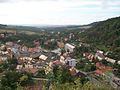 View from the castle to the city


References
- ^ Statistical Office of the Slovak Republic (www.statistics.sk). "Hustota obyvateľstva - obce". www.statistics.sk. Retrieved 2024-02-08.
- ^ a b c d "Základná charakteristika". www.statistics.sk (in Slovak). Statistical Office of the Slovak Republic. 2015-04-17. Retrieved 2022-03-31.
- ^ Statistical Office of the Slovak Republic (www.statistics.sk). "Počet obyvateľov podľa pohlavia - obce (ročne)". www.statistics.sk. Retrieved 2024-02-08.
- ^ a b "Municipal Statistics". Statistical Office of the Slovak republic. Archived from the original on 2007-11-16. Retrieved 2007-12-15.
External links
 Media related to Modrý Kameň at Wikimedia Commons
- Official website

- Castle Museum
| International | |
|---|---|
| National | |