
Molenbeek-Saint-Jean
Molenbeek-Saint-Jean
| |
|---|---|
 | |
 Flag  Coat of arms | |
Location of Molenbeek-Saint-Jean  | |
 Molenbeek-Saint-Jean Location in Belgium
Molenbeek municipality in the Brussels-Capital Region MR | |
| Area | |
| • Total | 6.02 km2 (2.32 sq mi) |
| Population (2020-01-01)[1] | |
| • Total | 97,979 |
| • Density | 16,000/km2 (42,000/sq mi) |
| Postal codes | 1080 |
| NIS code | 21012 |
| Area codes | 02 |
| Website | molenbeek.irisnet.be/fr (in French) molenbeek.irisnet.be/nl (in Dutch) |
Molenbeek-Saint-Jean (
From its origins in the
Molenbeek is a mostly residential municipality consisting of several historically and architecturally distinct districts.[13][14] As of 1 January 2022[update], the municipality had a population of 97,697 inhabitants.[15] The total area is 6.02 km2 (2.32 sq mi), which gives a population density of 16,268/km2 (42,130/sq mi), twice the average of Brussels.[15] Its upper area is greener and less densely populated.
Toponymy
Etymology

The name Molenbeek derives from two Dutch words: molen, meaning "mill", and beek, meaning "brook";[16] and could be literally translated as "Millbrook" in English.[17] It is a very common name for brooks in the Netherlands and Belgium, such as the Molenbeek (Erpe-Mere Bovenschelde), as well as the Molenbeek-Ter Erpenbeek, both in the Denderstreek, Belgium.
Although first applied to the brook that flowed through the village,[2] the name Molenbeek (originally spelled Molembecca) eventually came to be used to designate the village itself, around the year 985.[16] The suffix Saint-Jean in French or Sint-Jans in Dutch, meaning "Saint John", refers to the parish's patron saint, Saint John the Baptist, though it is seldom used in everyday speech, today's inhabitants—whether French or Dutch speaking—usually shortening the name to simply Molenbeek.[4]
Pronunciation
In French, Molenbeek-Saint-Jean is pronounced [molənbeːk sɛ̃ ʒɑ̃] (the "-beek" is pronounced with a long "a", like "bake" in English), and in Dutch, Sint-Jans-Molenbeek is pronounced [sɪɲˈcɑns ˈmoːlə(m)ˌbeːk] ⓘ. Inhabitants of Molenbeek are known in French as Molenbeekois (pronounced [molənbeːkwa]) and in Dutch as Molenbeekenaars (pronounced [ˈmoːlə(m)ˌbeːkənaːrs]). In France, the pronunciations [molənbɛk sɛ̃ ʒɑ̃] ("-bek" with a short "e", like "beck" in English) and [molənbɛkwa] (for molenbeekois) are often heard, but are rather rare in Belgium. The dialectal forms Muilebeik and Meulebeik are still used by older adults of Belgian ancestry, whilst the abbreviations Molen and Molem are common among younger speakers.[4]
History
Rural beginnings
As early as the 9th century, Molenbeek was the site of a church dedicated to Saint John the Baptist. The parish boundaries of St. John's Church were much greater than today, reaching as far as the river Senne,[18][19] and from the end of the 12th century, included a chapel dedicated to Saint Catherine.[20] This chapel was split off from the rest of the parish following the construction of Brussels' second city walls and gradually became the current St. Catherine's Church in the Sainte-Catherine/Sint Katelijne neighbourhood of Brussels.[21][19] The first documented mention of Molenbeek was made on 9 April 1174 in a papal bull by Pope Alexander III listing the property of the chapter of the Collegiate Church of St. Michael and St. Gudula (now a cathedral) in Brussels, which included St. John's Church, as well as other property.[22][23] The Brussels Beguinage, founded before 1247 outside the city walls,[24] also depended on Molenbeek.
_by_Pieter_Brueghel_II.jpg)
In the early
Molenbeek was made part of
Industrialisation

At the end of the 18th century, the Industrial Revolution brought prosperity back to Molenbeek through commerce and manufacturing. In 1795, under the French regime, the town regained its status as an independent municipality.[19][27][28] Around that time, Molenbeek experienced its first wave of urbanisation with the development of a neighbourhood, known as the Faubourg Saint-Martin, around a number of streets to the immediate west of the City of Brussels, as well as another, the Faubourg de Flandre, a little more to the north.[29]
During the first quarter of the 19th century, several hundred workers were employed in Molenbeek's chemical and textile industries.[3] In total, there were fifty companies in Molenbeek in 1829. The opening of the Brussels–Charleroi Canal in 1832 greatly increased the traffic of coal and thus the mechanisation of industry, which led to the development of foundries, engineering and metalworking companies in the municipality.[3][30] Attracted by the industrial opportunities, many workers moved in, first from the other Belgian provinces (mainly rural residents from Flanders)[31] and France, then from Southern European, and more recently from Eastern European and African countries.
_12-02-2010_15-07-38.jpg)
The growth of the community continued unabated throughout the 19th century, leading to cramped living conditions, especially near the canal.
20th century
Until the early 20th century, Molenbeek was a booming suburb which attracted a large working-class population. Remarkable new urban developments and garden cities such as the Cité Diongre were built at the beginning of the century to house the influx of newcomers.[35][36] The Church of St. John the Baptist was also rebuilt between 1930 and 1932 in Art Deco style to accommodate this growing populace.[37][38] The industrial decline, however, which had already started before World War I, accelerated after the Great Depression and World War II.[36]
Following the industrial decline after the war, the old districts bordering the City of Brussels began to decrease in population. Much of the original Belgian working-class population, when its financial means allowed it, left the lower Molenbeek for Brussels' newly developing suburbs. In this lower part of the town, new immigrant populations moved in, leading to the present-day urban fabric. The depopulation was not addressed until the 1960s through the construction of new residential areas in the then-rural west of the municipality. In the 1990s, this expansion was halted, leaving some woods and meadows in Molenbeek, such as the semi-natural site of the Scheutbos.[39][40]

Where Molenbeek was once a centre of intense industrial activity, concentrated around the canal and the railway, most of those industries have disappeared to make way for large-scale
21st century
In some areas of Molenbeek, the ensuing poverty left its mark on the urban landscape and scarred the social life of the community, leading to rising crime rates and pervading cultural intolerance. Various local revitalisation programmes are currently under way, aiming at relieving the municipality's most impoverished districts.

Attempts at revitalising the municipality have, however, not always been successful. In June 2011, the multinational company BBDO, citing over 150 attacks on their staff by locals, posted an open letter to then-mayor Philippe Moureaux, announcing its withdrawal from the municipality.[43] As a result, serious questions were raised about governance, security and the administration of Moureaux.[44] Following a general decrease in crime, the company finally decided to remain in Molenbeek.[45]
Terrorism
According to
November 2015 Paris attacks
At least four of the terrorists in the
Police investigation
Since several of the attackers in the Brussels and Paris terrorist attacks had connections to the area, Belgian police started door-to-door checks in which a quarter of Molenbeek's inhabitants were investigated, a total of 22,668. This operation resulted in that of the 1,600 organisations investigated, 102 were found to be involved with crime and a further 52 were involved with terrorism. 72 individuals were found to have a terrorist connection and were subject to future surveillance.[61][62]
Geography
Location

Molenbeek is located in the north-central part of Belgium, about 110 kilometres (68 mi) from the Belgian coast and about 180 km (110 mi) from Belgium's southern tip. It is located in the heartland of the Brabantian Plateau, about 45 km (28 mi) south of
Climate
Molenbeek, in common with the rest of Brussels, experiences an oceanic climate (Köppen: Cfb) with warm summers and cool winters.[63] Proximity to coastal areas influences the area's climate by sending marine air masses from the Atlantic Ocean. Nearby wetlands also ensure a maritime temperate climate. On average (based on measurements in the period 1981–2010), there are approximately 135 days of rain per year in the region. Snowfall is infrequent, averaging 24 days per year. It also often experiences violent thunderstorms in summer months.
The Royal Meteorological Institute of Belgium (IRM/KMI) is located in Uccle, in the south of Brussels. The meteorological records which are carried out there are similar to those which could be carried out in Molenbeek.
| Climate data for Brussels-Capital Region (1981–2010) | |||||||||||||
|---|---|---|---|---|---|---|---|---|---|---|---|---|---|
| Month | Jan | Feb | Mar | Apr | May | Jun | Jul | Aug | Sep | Oct | Nov | Dec | Year |
| Mean daily maximum °C (°F) | 5.9 (42.6) |
6.8 (44.2) |
10.5 (50.9) |
14.2 (57.6) |
18.3 (64.9) |
20.9 (69.6) |
23.3 (73.9) |
23.0 (73.4) |
19.5 (67.1) |
15.1 (59.2) |
9.8 (49.6) |
6.3 (43.3) |
14.5 (58.1) |
| Daily mean °C (°F) | 3.2 (37.8) |
3.5 (38.3) |
6.5 (43.7) |
9.5 (49.1) |
13.5 (56.3) |
16.1 (61.0) |
18.4 (65.1) |
18.0 (64.4) |
14.9 (58.8) |
11.1 (52.0) |
6.8 (44.2) |
3.8 (38.8) |
10.4 (50.7) |
| Mean daily minimum °C (°F) | 0.7 (33.3) |
0.6 (33.1) |
2.9 (37.2) |
4.9 (40.8) |
8.7 (47.7) |
11.5 (52.7) |
13.6 (56.5) |
13.0 (55.4) |
10.5 (50.9) |
7.5 (45.5) |
4.5 (40.1) |
1.5 (34.7) |
6.7 (44.1) |
| Average precipitation mm (inches) | 75.2 (2.96) |
61.6 (2.43) |
69.5 (2.74) |
51.0 (2.01) |
65.1 (2.56) |
72.1 (2.84) |
73.6 (2.90) |
76.8 (3.02) |
69.6 (2.74) |
75.0 (2.95) |
77.0 (3.03) |
81.4 (3.20) |
848.0 (33.39) |
| Average precipitation days (≥ 1 mm) | 12.8 | 11.1 | 12.7 | 9.9 | 11.3 | 10.5 | 10.1 | 10.1 | 10.4 | 11.2 | 12.6 | 13.0 | 135.6 |
| Mean monthly sunshine hours | 58 | 75 | 119 | 168 | 199 | 193 | 205 | 194 | 143 | 117 | 65 | 47 | 1,583 |
| Source: KMI/IRM[64] | |||||||||||||
Districts

There are two distinct areas in Molenbeek: a lower area and an upper area. The lower area, next to the canal, consists of
The territory of Molenbeek is very heterogeneous and is characterised by a mixture of larger districts including smaller residential and (formerly) industrial neighbourhoods. The area along the canal is currently experiencing a large revitalisation programme, as part of the Plan Canal of the Brussels-Capital Region.[14]
Lower Molenbeek
Historical centre
.jpg)
The historical centre of Molenbeek is the municipality's central district. It developed during the Industrial Revolution along the Brussels–Charleroi Canal and is currently in a fragile social and economic situation due to the decline of its economy and the poor quality of some of its housing. The Municipal Hall of Molenbeek is located on the Place Communale/Gemeenteplein ("Municipal Square"), at the heart of this district.[65]
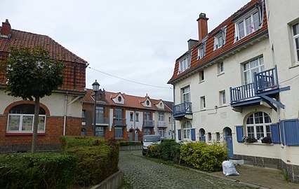
Duchesse (Quatre-vents)

Located to the south of the historical centre of Molenbeek, this district is centred on the Place de la Duchesse de Brabant/Hertogin van Brabantplein. The square was created in 1847 on the grounds of the Hospices de Bruxelles, of which only the neoclassical facade remains. The hospice buildings now house a primary school (municipal school no. 5). In 1869, the Church of St. Barbara was erected there for the Catholic worship of the new parish.[66] The Rue de Birmingham/Birminghamstraat, the Rue de Manchester/Manchesterstraat, the Rue de la Princesse/Prinsesstraat, the Rue Vanderstraeten/Vanderstraetenstraat and the Rue Isidoor Teirlinck/Isidoor Teirlinckstraat also end there.
Heyvaert
Located in the south-east of Molenbeek, near the Abattoirs of Anderlecht (the main slaughterhouse in Brussels) and along the Charleroi Canal, Heyvaert is part of the larger Cureghem/Kuregem district and is bounded by the Rue Nicolas Doyen/Nicolas Doyenstraat, the Rue de Birmingham, the Place de la Duchesse de Brabant, the Rue Isidoor Teirlinck, the Rue Delaunoy/Delaunoystraat, and the Rue Heyvaert/Heyvaertstraat (formerly the Rue de l'Écluse/Sasstraat, because of its proximity to the canal lock; écluse meaning "lock" in French).
Maritime

Located in the north of Molenbeek, the Maritime district was born, around 1900, from the implementation of the
Upper Molenbeek
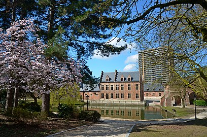
Karreveld
Located in the north of the upper part of Molenbeek, Karreveld Park and its surrounding district are named after the former domain of Karreveld Castle, which now covers 3 ha (7.4 acres). Today, it is a mostly residential neighbourhood between the Avenue de la Liberté/Vrijheidslaan, the Chaussée de Gand/Gentsesteenweg and the railroad.
Korenbeek
Located in the north-east of Molenbeek, Korenbeek is home to Molenbeek Cemetery between the Chaussée de Gand and the Boulevard Louis Mettewie/Louis Mettewielaan. This cemetery was inaugurated on 16 August 1864 to replace the old parish cemetery around the Church of St. John the Baptist, which had become too small, and whose last remains were cleared in 1932.[67][68]
Machtens (Marie-José)

Located in the upper part of Molenbeek, this district is located in the valley of the Maalbeek (or Molenbeek) that gave the municipality its name. Originally, the area was part of the former Oostendaal estate. In 1920, it was purchased by the municipality and partly turned into two parks, Albert Park and Marie-José Park, in the triangle formed by the Boulevard Edmond Machtens/Edmond Machtenslaan, the Avenue De Roovere/De Rooverelaan and the Boulevard Joseph Baeck/Joseph Baecklaan. They were designed by the architect and urban planner Louis Van der Swaelmen, and are named after King
Osseghem/Ossegem
Osseghem/Ossegem is centrally located in the upper part of Molenbeek, west of the municipality's historical centre. The neighbourhood used to be a rural
Scheutbos (Mettewie)
Located in the extreme west of Molenbeek, near the Boulevard Louis Mettewie, the Scheutbos (or Scheutbosch) is the municipality's remaining "green" area, home to the likewise named semi-natural site of the Scheutbos.[39][40]
Main sights

Molenbeek-Saint-Jean has a rich cultural and architectural heritage.[69] Some of the main points of interest include:
- The Municipal Hall of Molenbeek, located on the Place Communale/Gemeenteplein, designed in eclectic style by the architect Jean-Baptiste Janssens, which was opened in 1889.[65]
- The Church of St. John the Baptist, a Catholic parish church designed in Art Deco style by the architect Joseph Diongre and built in 1931–32,[70] which has been listed as a protected monument since 1984.[38]
- The Church of St. Remigius, located on the Boulevard du Jubilé/Jubelfeestlaan, a neo-Gothic building completed in 1907.[71]
- The Church of St. Barbara, located on the Place de la Duchesse de Brabant/Hertogin van Brabantplein, another neo-Gothic building completed in 1894 and listed since 1998.[66]
- Molenbeek Cemetery, which contains remarkable monuments, including funerary galleries and a columbarium built in 1880.[67][68]
- Karreveld Castle and its surrounding park, which are used for cultural events and meetings of the municipal council. At the beginning of the 20th century, it was one of the birthplaces of Belgian Cinema. At the request of Charles Pathé (Pathé Cinéma), the director Alfred Machin commissioned the first film studio in the country, together with a workshop for the construction of film sets and a mini zoological garden for exotic animals, such as bears, camels and panthers used as 'extras' in films. Several films, including the first two Belgian feature films La Fille de Delft and the sadly prophetic Maudite soit la guerre (in hand-painted colours) were shot by Alfred Machin in the studio of Karreveld Castle. Since 1999, the castle hosts from mid-July to September the Festival Bruxellons!, a theatre festival open to other performing arts (i.e. magic, music, circus, etc.).[72]
- The Municipal Museum of Molenbeek (MoMuse), housed in the prestigious building of the Academy of Drawing and Visual Arts.[73][74]
- The Vaartkapoen statue, on the Place Sainctelette/Sainctelettesquare.[75]
Moreover, several rundown industrial buildings have been renovated and converted into prime real estate and other community functions. Examples include:
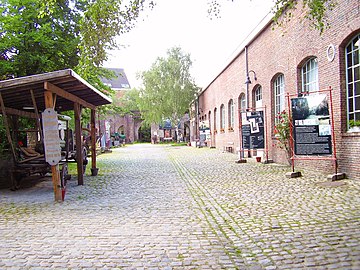
- The Fonderie, a former smelter of the Compagnie des Bronzes de Bruxelles, operational from 1854 to 1979, now home to Brussels' Museum of Industry and Labour. The museum focuses on the industry, coupled with the social history of Molenbeek, and the impact of industrialisation on the development of the municipality.[41][42]
- The Raffinerie, a former sugar refinery, now the site of a cultural and modern dance complex.
- The Bottelarij, a bottling plant that housed the Royal Flemish Theatre during its renovation in the centre of Brussels.
- The Millennium Iconoclast Museum of Art (MIMA), a museum dedicated to culture 2.0 and to urban art opened in April 2016, in the former buildings of the Belle-Vue brewery, and is the first of the kind in Europe.[73][76]
- The impressive buildings of the former goods station of Tour & Taxis and the surrounding area bordering the municipality, which are being turned into residences, as well as commercial enterprises.[77]
- Brussels' Circus School, installed in the buildings of Tour & Taxis.[78]
-
-

-
 Cité Diongre garden city
 -
 The Fonderie, Brussels' Museum of Industry and Labour


Demographics
Historical population
Historically, the population of Molenbeek was quite low. The municipality counted fewer than 2,000 inhabitants at the beginning of the 19th century. However, following the Industrial Revolution, the population underwent a remarkable growth, peaking at 72,783 in 1910. From then, it began to decrease slightly during the first half of the 20th century to a low of 63,528 in 1961, before increasing again rapidly in recent years.[79]
As of 1 January 2020[update], the population was 97,979.[15] The area is 6.02 km2 (2.32 sq mi), making the density 16,314/km2 (42,250/sq mi).[15] The population is relatively young—the average age is 35 years—with nearly 29% under 18 years old, and fewer than 12% over 65.[15] This population, while already impoverished and overcrowded, has further increased by 24.5% in the last decade.[80]

- Sources: INS: 1806 to 1981= census; 1990 and later = population on 1 January
Foreign population
| 5,960 | |
| 4,242 | |
| 2,255 | |
| 1,956 | |
| 1,759 | |
| 1,666 | |
| 1,040 |
The population has been described as "mainly Muslim" in the media;[82] however, actual figures are estimated to range between 25% and 40%, depending on the catchment area.[7] Belgium does not collect statistics by religious beliefs, so exact figures are unknown, but the Muslim minority in the community is visibly significant.[6]
As of 2016[update], there is one main minority group in Molenbeek,
As of 2023[update], taking into account the nationality of birth of the parents, 69.16% of Molenbeek's population has recent heritage from non-European countries (predominantly Morocco and Syria), 17.49% is from another European country (mainly Romania, Spain, France, Italy, and Poland), while the native Belgian population is 13.31%.[84] Among all major migrant groups from outside the EU, a majority of the permanent residents have acquired Belgian nationality.[85]
| Group of origin | Year | |
|---|---|---|
| 2023[86] | ||
| Number | % | |
| Belgians with Belgian background | 13,083 | 13.31% |
| Belgians with foreign background | 56,630 | 57.63% |
| Neighbouring country | 1,873 | 1.91% |
| EU27 (excluding neighbouring country) | 3,338 | 3.4% |
| Outside EU 27 | 51,419 | 52.32% |
| Non-Belgians | 28,557 | 29.06% |
| Neighbouring country | 2,301 | 2.34% |
| EU27 (excluding neighbouring country) | 9,709 | 9.88% |
| Outside EU 27 | 16,547 | 16.84% |
| Total | 98,270 | 100% |
Politics
Molenbeek is governed by an elected municipal council and an executive college of the mayor and aldermen. The longtime mayor from 1992 to 2012 was
The 2018 local elections saw PS return to the majority, with a coalition between the aforementioned and MR being agreed upon.[87] The current mayor is Catherine Moureaux.
 | ||||||||||
| Party | ||||||||||
|---|---|---|---|---|---|---|---|---|---|---|
| Votes | % | Swing (pp) | Elected 2018 |
Change | ||||||
sp.a
|
12,122 | 31.34 | 17 / 45 (38%)
|
|||||||
| MR – Open Vld | 9,268 | 23.96 | 13 / 45 (29%)
|
|||||||
| PVDA-PTB | 5,262 | 13.61 | 7 / 45 (16%)
|
|||||||
| cdH – CD&V | 3,246 | 8.39 | 3 / 45 (7%)
|
|||||||
| Ecolo | 3,163 | 8.18 | 3 / 45 (7%)
|
|||||||
| DéFI | 1,842 | 4.76 | 1 / 45 (2%)
|
|||||||
| N-VA | 1,307 | 3.38 | 1 / 49 (2%)
|
|||||||
| Groen | 940 | 2.43 | New | 0 / 49 (0%)
|
- | |||||
| Molenbeek Act | 734 | 1.90 | New | 0 / 45 (0%)
|
- | |||||
ISLAM (political party)
|
695 | 1.80 | 0 / 45 (0%)
|
|||||||
| CITOYEN D'EUROPE M3E | 95 | 0.25 | New | 0 / 45 (0%)
|
- | |||||
Mayors

Historical list of mayors or burgomasters of Molenbeek:[89]
Pre-independence (before 1830)
- 1800–1812: J.-B. De Roy
- 1812–1818: FR. De Putte
- 1818–1819: V. Van Espen
- 1819–1830: F. Vanderdussen
Kingdom of Belgium (1830–present)
| Name | Start date | End date | Length | Political Party | |
|---|---|---|---|---|---|
| Charles De Roy | 1830 | 1836 | 6 years | ||
| Pierre-Joseph Meeûs | 1836 | 1842 | 6 years | ||
| Albert Vanderkindere | 1843 | 1848 | 5 years | ||
| H.-J.-L. Stevens | 1848 | 1860 | 12 years | ||
| J.-B. Debauche | 1861 | 1863 | 2 years | ||
| L.-A. De Cock | 1864 | 1875 | 11 years | ||
| Guillaume Mommaerts | 1876 | 1878 | 2 years | ||
| Henri Hollevoet | 1879 | 1911 | 32 years | Liberal | |
| Julien Hanssens | 1912 | 1914 | 2 years | Liberal | |
| Louis Mettewie | 1914 | 1938 | 24 years | Liberal | |
| Edmond Machtens | 1938 | 1978 | 40 years | PSB | |
| Marcel Piccart | 1978 | 1989 | 11 years | PS
| |
| FDF | |||||
| Léon Spiegels | 1989 | 1992 | 3 years | PRL | |
| Philippe Moureaux | 1992 | 2012 | 20 years | PS | |
| Françoise Schepmans | 2012 | 2018 | 6 years | MR
| |
| Catherine Moureaux | 2018 | Present | Ongoing | PS | |
Sports
As in the rest of Brussels, sport in Molenbeek is under the responsibility of the
Football

Molenbeek's historical football club,
Other sports
The municipality is home to the Royal Daring Hockey Club Molenbeek, a field hockey club.[94]
Education
Most of Molenbeek pupils between the ages of 3 and 18 go to schools organised by the
Primary education
There are 17 French-language and six Dutch-language primary schools in Molenbeek.[95]
Secondary education
Transportation
Road network
The Boulevard Léopold II/Leopold II-laan in the north of Molenbeek is part of a monumental east–west axis, at the end of which is the National Basilica of the Sacred Heart in Koekelberg. Some other main roads that cross the municipality are the Chaussée de Gand/Gentsesteenweg, the Boulevard Edmond Machtens/Edmond Machtenslaan and the Chaussée de Ninove/Ninoofsesteenweg running east–west, as well as the Boulevard Louis Mettewie/Louis Mettewielaan running north–south.
Public transport
Molenbeek is served by
Waterways
Molenbeek is on the route of the second largest axis of the Belgian network of inland waterways, that is the Antwerp–Brussels–Charleroi axis via the maritime Scheldt, the Maritime Canal and the Brussels–Charleroi Canal.
Parks and green spaces
Green spaces in the municipality include:[40]
- Scheutbos Park, a regional nature park of 6 ha (15 acres)
- Semi-natural site of the Scheutbos, a protected area of 44 ha (110 acres)
- Karreveld Park 3 ha (7.4 acres)
- Marie-José Park 6 ha (15 acres)
- Albert Park
- Muses' Park
- Hauwaert Park
- Bonnevie Park
- Fonderie Park
-
![Scheutbos [fr; nl] regional nature park](//upload.wikimedia.org/wikipedia/commons/thumb/5/55/Scheutbospark.jpg/180px-Scheutbospark.jpg) Scheutbos regional nature park
Scheutbos regional nature park -
 Albert Park
 -
 Tour & Taxis Park
![Scheutbos [fr; nl] regional nature park](/File:Scheutbospark.jpg)


Notable inhabitants
- Salah Abdeslam (b. 1989), French jihadist terrorist involved in the November 2015 Paris attacks
- Montasser AlDe'emeh (b. 1989), Belgian-Palestinian researcher
- Richard Beauthier (1913–1999), politician, senator, and mayor of Jette, was born there.
- Norbert Benoit (Norbert Benoit Van Peperstaete) (1910–1993), filmmaker
- Louis Bertrand (1856–1943), politician, author, and Minister of State
- Ado Chale (b. 1928), artist
- Serge Creuz (1924–1996), painter
- Jean De Middeleer (1908–1986), musician
- Eugène Demolder (1862–1919), writer
- Joseph Diongre (1878–1963), modernist architect
- Alfred Dubois (1898–1949), professor at the Brussels Conservatory, violinist, and teacher of the violinist Arthur Grumiaux
- Alexis Dumont (1877–1962), architect of the Citroën building (now part of KANAL - Centre Pompidou), was born there.
- Ferdinand Elbers (1862–1943), mechanic, trade unionist, politician, and senator
- Hendrik Fayat (1906–1997), politician
- Eugene Hins (1839–1923), founder of the newspaper La Pensée, leader of the Belgian freethinking movement, and co-founder of the Socialist International
- Marcel Josz (1899–1984), actor, was born there.
- Eugène Laermans (1864–1940), painter and engraver
- Daniel Leyniers, Esq. (1881–1957), politician, senator, and mayor of Itterbeek, was born there.
- Marka, Serge Van Laeken (b. 1961), singer, songwriter, composer, and filmmaker
- Neder-over-Heembeek in 1830 and Molenbeek from 1836 to 1842, registrar of the Court of Audit from 1831 to 1836, decorated with the Belgian Iron Cross. He lived at 7, Faubourg de Flandre.
- Henry Meuwis (1870-1935), painter
- Georges Mogin, also known as Norge (1898–1990), poet
- Economic History at the Université libre de Bruxelles(ULB)
- Michel Mourlon (1845–1915), geologist, palaeontologist, and curator of the Museum of Natural Sciences of Belgium
- Jean Muno (1924–1988), writer
- Zeynep Sever (b. 1989), Miss Belgium 2008
- Robert Schuiten (1912–1997), architect and painter
- Jean Stampe (1889–1978), war pilot and aircraft manufacturer including of the famous Stampe SV-4
- Eric Struelens (b. 1969), professional basketballplayer
- Herman Teirlinck (1879–1967), writer
- Pierre Tetar van Elven (1828–1908), painter
- Toots Thielemans (1922–2016),[99] jazz artist
- Henri Joseph Thomas (1878–1972), painter
- Pierre Van Humbeeck (1829–1890), politician and Minister of Education
- Leon Vanderkindere (1842–1906), historian and prominent professor at the Free University of Brussels, was born there.
- Philippe Vandermaelen (1795–1869), world-renowned geographer and cartographer. He founded the geographical establishment of Brussels in Molenbeek.
- Franky Vercauteren (b. 1956), football personality
- Firmin Verhevick (1874–1962), painter, was born there.
- Thierry Zéno (1950–2017), author-filmmaker
International relations
Twin towns and sister cities
Molenbeek is twinned with:
 Oujda, Morocco
 Levallois-Perret, France
References
Citations
- ^ "Bevolking per gemeente op 1 januari 2020". Statbel.
- ^ a b Demanet & De Zuttere 2023, p. 6–7.
- ^ a b c Charruadas 2005.
- ^ a b c d Steffens 2007.
- ^ a b c d e f "Histoire en quelques mots – Français". molenbeek.irisnet.be. Retrieved 12 January 2017.
- ^ a b Torrekens 2007.
- ^ a b "781.887 musulmans vivent en Belgique: découvrez la carte, commune par commune". sudinfo.be (in French). Retrieved 26 September 2021.
- ^ Levitt, Matthew (27 March 2016). "My Journey To Brussels' Terrorist Safe Haven". Politico.
- ^ "Brussels attacks: Molenbeek's gangster jihadists". BBC. 24 March 2016. Retrieved 13 April 2016.
- ^ "The Belgian neighborhood indelibly linked to jihad". The Washington Post. 15 November 2015. Retrieved 13 April 2016.
- ^ "Beleaguered Molenbeek struggles to fend off jihadist recruiters". The Times of Israel. 3 April 2016. Retrieved 13 April 2016.
- ^ "World points to "jihad Capital" Molenbeek". Het Niuewsblad. 16 November 2015. Retrieved 13 April 2016.
- ^ a b "Molenbeek-Saint-Jean". be.brussels. Retrieved 18 November 2015.
- ^ a b c "Plan canal: des ambitions, une méthode, une équipe | Canal.brussels". canal.brussels. Retrieved 28 April 2017.
- ^ a b c d e "Molenbeek-Saint-Jean | IBSA". ibsa.brussels. Retrieved 24 September 2021.
- ^ a b Anne-Cécile Wagner, Molenbeek entre moulins et ruisseau, Le Soir (in French), 15 July 2005
- ^ Demanet & De Zuttere 2023, p. 7.
- ^ Verbesselt 1965, p. 159–199.
- ^ a b c d Onclincx 1977, p. 34.
- ^ Lefèvre 1942, p. 206–208.
- ^ Laurent 1963, p. 161–235.
- ^ a b Onclincx 1977, p. 34–35.
- ^ Demanet & De Zuttere 2023, p. 3.
- ^ Mardaga 1989, p. 104.
- ^ Onclincx 1977, p. 35.
- ^ Demanet & De Zuttere 2023, p. 3–4.
- ^ Demanet & De Zuttere 2023, p. 8.
- ^ "Molenbeek, les grandes lignes de son développement au 19e siècle" (PDF). 2020. Retrieved 4 June 2023.
- ^ Demanet & De Zuttere 2023, p. 10.
- ^ Demanet & De Zuttere 2023, p. 8–9, 14–26.
- ^ Buron 2016, p. 80–82.
- ^ Demanet & De Zuttere 2023, p. 24–26.
- ^ Wolmar 2010, p. 18–20.
- ^ Demanet & De Zuttere 2023, p. 14.
- ^ "Cité Diongre – Inventaire du patrimoine architectural". monument.heritage.brussels (in French). Retrieved 16 November 2023.
- ^ a b "Étude de cas. Le quartier rural de Molenbeek-Saint-Jean 1869-1930" (PDF). 2020. Retrieved 4 June 2023.
- ^ Demanet & De Zuttere 2023, p. 38–39.
- ^ a b "Molenbeek-Saint-Jean – église Saint-Jean-Baptiste – Parvis Saint-Jean-Baptiste – DIONGRE Joseph". irismonument.be. Retrieved 1 September 2019.
- ^ a b "Scheutbos: grand espace vert bruxellois". scheutbos.be. Retrieved 1 September 2019.
- ^ a b c "Espaces verts à Molenbeek-Saint-Jean – Français". molenbeek.irisnet.be. Retrieved 29 December 2016.
- ^ a b Demanet & De Zuttere 2023, p. 18–19.
- ^ a b "La Fonderie - Brussels Museum of Industry and Work". Brussels Museums. 14 September 2023. Retrieved 16 November 2023.
- ^ "Insécurité à Molenbeek" [Insecurity in Molenbeek]. La Capitale (in French). 17 June 2011. Retrieved 18 November 2015.
- ^ "BBDO zwaar ontgoocheld in Moureaux" [BBDO greatly disappointed by Moureaux]. De Standaard (in Dutch). 17 June 2011. Retrieved 18 November 2015.
- ^ "Reclamebureau BBDO: 'Geen incidenten meer'". bruzz.be (in Dutch). Retrieved 27 September 2021.
- ^ Stroobants, Jean Pierre (16 November 2015). "Molenbeek, la plaque tournante belge du terrorisme islamiste". Le Monde (in French). Retrieved 12 April 2016.
c'est de Molenbeek que sont partis les tueurs du commandant afghan Ahmed Shah Massoud, principal adversaire du régime des talibans, assassiné par deux faux journalistes.
- ^ Bartunek, Robert-Jan; Lewis, Barbara (15 November 2015). "Belgian connection: three held in Brussels over Paris attacks". Reuters. Retrieved 11 April 2016.
A prominent, Moroccan-born member of the group behind the 2004 Madrid train bombings that killed 191 was from Molenbeek.
- ^ "Why did the bombers target Belgium?". The Guardian. 22 March 2016. Retrieved 11 April 2016.
Hassan el-Haski – Madrid and Casablanca bombings – A Spanish judge sentenced Haski to 14 years in jail for belonging to a terrorist organisation, in connection with the March 2004 attacks on Madrid.
- ^ Newton-Small, Jay (16 November 2015). "The Belgian Suburb at the Heart of the Paris Attacks Probe". Time. Retrieved 11 April 2016.
May 2014, three people were killed and one injured in a shooting at the Jewish Museum of Belgium by alleged terrorist Mehdi Nemmouche, who is awaiting trial and spent time in Molenbeek
- De Redactie.
- ^ Lewis, Barbara; Bartunek, Robert-Jan (15 November 2015). "Belgian connection: three held in Brussels over Paris attacks". Reuters. Retrieved 11 April 2016.
Molenbeek. The area has been connected with two attacks in France this year. Security officials have said the Islamist who killed people at a Paris kosher grocery in January at the time of the attack on the magazine Charlie Hebdo acquired weapons in the district.
- ^ Lynch, Julia (5 April 2016). "Here's why so many of Europe's terrorist attacks come through this one Brussels neighborhood". The Washington Post. Retrieved 11 April 2016.
Molenbeek had been linked to radical Islamist terrorism. One of 19 'communes' in the Brussels metro area, the neighborhood was home to one of the attackers in the 2004 commuter train bombings in Madrid and to the Frenchman who shot four people at the Jewish Museum in Brussels in August 2014. The Moroccan shooter on the Brussels-Paris Thalys train in August 2015 stayed with his sister there. French police suspect that the weapons used in the Paris supermarket attack connected with the Charlie Hebdo attack in January 2015 were acquired in Molenbeek, and the attackers in the November 2015 Paris bombings were traced to Brussels by way of a parking ticket issued on a rental car in Molenbeek.
- ^ "Belgian minister says many Muslims 'danced' after attacks". Agence France-Presse. 16 April 2016. Archived from the original on 27 May 2018. Retrieved 26 May 2018.
They threw stones and bottles at police and press during the arrest of Salah Abdeslam. That is the real problem.
- ^ "Brussels station suspect had 'nail bomb'". BBC News. 21 June 2017.
- ^ "L'auteur de l'attentat manqué de Bruxelles avait des "sympathies" pour l'État islamique". Le Figaro (in French). Retrieved 21 June 2017.
L'homme abattu par les soldats à la gare centrale de Bruxelles était un Marocain de 36 ans. Il vivait à Molenbeek
- ^ "Paris attacks: Belgian Abdelhamid Abaaoud identified as presumed mastermind". CBC News. 16 November 2015. Retrieved 16 November 2015.
- ^ "Shots in Brussels raid tied to Paris attacks". CNN. 15 March 2016. Retrieved 15 March 2016.
- ^ "Gunfire in Brussels raid on 'Paris attacks suspects'". BBC News. 15 March 2016. Retrieved 15 March 2016.
- ^ "Paris attacks: Salah Abdeslam 'worth his weight in gold'". BBC News. 21 March 2016. Retrieved 21 March 2016.
- ^ "Schietpartij in Anderlecht was fait divers". Het Laatste Nieuws. 2 February 2010. Retrieved 23 March 2016.
- ^ "Belgium's Molenbeek home to 51 groups with terror links: report". Politico. 20 March 2017. Retrieved 28 March 2017.
- ^ "51 Molenbeekse vzw's verdacht van terreurbanden". De Morgen. 20 March 2017. Retrieved 28 March 2017.
- ^ "Brussels, Belgium Köppen Climate Classification (Weatherbase)". Weatherbase. Retrieved 2 July 2019.
- ^ "Klimaatstatistieken van de Belgische gemeenten, Brussel" (PDF). KMI/IRM. Archived from the original (PDF) on 2 March 2021. Retrieved 3 January 2021.
- ^ a b "The Maison Communale at Molenbeek". visit.brussels. Retrieved 30 April 2018.
- ^ a b "Molenbeek-Saint-Jean – Eglise Sainte-Barbe – Place de la Duchesse de Brabant – PEPERMANS Léopold". irismonument.be. Retrieved 1 September 2019.
- ^ a b Celis 2004, p. 12–17.
- ^ a b "Le Cimetière Communal de Molenbeek-Saint-Jean" (PDF). Retrieved 9 October 2021.
- ^ "Molenbeek-Saint-Jean – Inventaire du patrimoine architectural". monument.heritage.brussels (in French). Retrieved 6 October 2021.
- ^ "Church of St John the Baptist in Molenbeek". visit.brussels. Retrieved 30 April 2018.
- ^ "Molenbeek-Saint-Jean – Eglise Saint-Rémi – VERAART Chrétien". irismonument.be. Retrieved 14 December 2019.
- ^ "Festival Bruxellons!".
- ^ a b Demanet & De Zuttere 2023, p. 42.
- ^ "MoMuse – MuséeMolenbeekMuseum". momuse.be. Retrieved 1 September 2019.
- ^ "Le Vaartkapoen – Molenbeek-Saint-Jean | BE-monumen". be-monumen.be (in French). 1 April 2020. Retrieved 25 June 2022.
- ^ "MIMA : ouverture d'un musée du street art au coeur de Molenbeek". Retrieved 26 July 2016.
- ^ "Tour & Taxis | perspective.brussels". perspective.brussels (in French). 22 August 2017. Retrieved 7 June 2022.
- ^ "École de Cirque de Bruxelles – École de Cirque de Bruxelles" (in French). Retrieved 1 September 2019.
- ^ Sources: INS: 1806 to 1981= census; 1990 and later = population on 1 January
- ^ "La population de Molenbeek augmente de 25% en 10 ans" [The population of Molenbeek increases 25% in 10 years]. l'avenir.net (in French). Retrieved 18 November 2015.
- ^ Nationalités | IBSA (Report) (in French). Brussels Institute for Statistics and Analysis. Retrieved 10 July 2023.
- ^ "Paris attacks: Visiting Molenbeek, the police no-go zone that was home to two of the gunmen". The Independent. 17 November 2015. Retrieved 18 November 2015.
- ^ a b Capadites, Christina (11 April 2016). "Molenbeek and Schaerbeek: A tale of two tragedies". CBS News. Retrieved 12 September 2016.
- ^ "Origin | Statbel". statbel.fgov.be. Retrieved 4 July 2023.
- ^ "2.738.486 inwoners van vreemde afkomst in België op 01/01/2012" [2,738,486 inhabitants of foreign origin in Belgium on 01/01/2012]. Npdata.be (in Dutch). Archived from the original on 22 October 2019. Retrieved 12 March 2013.
- ^ "Origin | Statbel". statbel.fgov.be. Retrieved 2 July 2023.
- ^ "Molenbeek: accord de majorité entre le PS de Catherine Moureaux et le MR de Françoise Schepmans" (in French). RTBF. 29 October 2018. Retrieved 17 July 2021.
- ^ "Molenbeek-Saint-Jean" (in French). Retrieved 17 July 2021.
- ^ Maurissen 1980, p. 245.
- ^ "Portail officiel du sport en fédération Wallonie-Bruxelles" [Official sports portal in the Wallonia-Brussels Federation]. sport-adeps.be (in French). Archived from the original on 16 November 2017. Retrieved 11 November 2017.
- ^ "Doe aan sport" [Do sports]. Sport.Vlaanderen (in Dutch). Retrieved 11 November 2017.
- ^ "RWDM promoveert! Brusselse traditieclub volgend seizoen opnieuw in hoogste klasse na zege tegen RSCA Futures". hln.be (in Dutch). 13 May 2023. Retrieved 11 February 2024.
- ^ "Stade & Mobilité". RWDM (in French). Retrieved 11 February 2024.
- ^ "Royal Daring". royaldaring.be. Retrieved 23 October 2021.
- ^ "Ecoles communales fondamentales"/"Gemeentelijke basisscholen." Sint-Jans-Molenbeek. Retrieved on 8 September 2016.
- ^ "Autres écoles – Français". Retrieved 8 September 2016.
- ^ "Campus Toverfluit".
- ^ "Andere scholen – Nederlands". Retrieved 8 September 2016.
- ^ "Toots, an icon of the Brussels jazz scene". Visitbrussels.be. Archived from the original on 8 December 2015.
Bibliography
- Buron, Thierry (2016). "Molenbeek, de sainte Gertrude au djihadisme". Conflits (in French). 9. Paris.
- Celis, Marcel (2004). Cimetières et nécropoles. Bruxelles, ville d'Art et d'Histoire (in French). Vol. 38. Brussels: Éditions de la Région de Bruxelles-Capitale.
- Charruadas, Paulo (2005). "La formation de Molenbeek : industrialisation et urbanisation". Les Cahiers de la fonderie (in French). 33. Brussels.
- Demanet, Marie; De Zuttere, Catherine (2023). The heart of Molenbeek. Brussels, City of Art and History. Vol. 61. Brussels: urban.brussels (Regional Public Service of Brussels, Urbanism and Heritage). ISBN 978-2-87584-205-3.
- Laurent, René (1963). "Les limites des paroisses à Bruxelles aux XIVe et XVe siècles". Les Cahiers bruxellois (in French). 8. Brussels.
- Lefèvre, Pl.-F. (1942). L'Organisation ecclésiastique de la Ville de Bruxelles au Moyen-Age (in French). Leuven: Bibliothèque de l'Université catholique de Louvain.
- Maurissen, Antoon-Willem (1980). Bijdrage tot de geschiedenis van Sint-Jans-Molenbeek (in Dutch). Puurs: Baeté.
- Onclincx, Georges (1977). "Molenbeek-Saint-Jean. Histoire d'un village". L'École et la ville (in French). 11. Brussels: Commission française de la culture de l'agglomération de Bruxelles.
- Steffens, Sven (2007). "Urban popular place names past and present: the case of Molenbeek-Saint-Jean/Sint-Jans-Molenbeek". Brussels Studies: The Journal of Research on Brussels. 9. Brussels.
- Torrekens, Corinne (2007). "Concentration of Muslim populations and structure of Muslim associations in Brussels". Brussels Studies: The Journal of Research on Brussels. 4. Brussels.
- Verbesselt, Jan (1965). Het Parochiewezen in Brabant tot het einde van de 13e eeuw (in Dutch). Vol. 4. Zoutleeuw: Peeters.
- ISBN 978-1-84887-171-7.
- Le Patrimoine monumental de la Belgique: Bruxelles (PDF) (in French). Vol. 1A: Pentagone A-D. Liège: Pierre Mardaga. 1989.
Further reading
- Lamfalussy, Christophe; Martin, Jean-Pierre (2017). Molenbeek-sur-djihad. Paris: Grasset. ISBN 9782246862765.
- Chalmers, Robert (April 2017). "Is Molenbeek really a no-go zone?". British GQ.
- "Molenbeek: Life Inside the So-Called 'Jihadi Capital of Europe". ABC News. 3 April 2016. Archived from the original on 11 December 2021.
External links
 Media related to Molenbeek-Saint-Jean at Wikimedia Commons
- Official website
 (in French and Dutch)
Places adjacent to Molenbeek-Saint-Jean | ||||||||||||||||
|---|---|---|---|---|---|---|---|---|---|---|---|---|---|---|---|---|
| ||||||||||||||||

| International | |
|---|---|
| National | |
| Geographic | |