
Montagne d'Ambre National Park
| Montagne d'Ambre National Park | |
|---|---|
 Location of Amber Mountain National Park | |
| Location | Diana Region, Madagascar |
| Nearest city | Antsiranana |
| Coordinates | 12°35′42″S 49°09′18″E / 12.595°S 49.155°E |
| Area | 182 km2 (70 sq mi) |
| Established | 28 October 1958 |
| Governing body | Madagascar National Parks (PNM-ANGAP) |
| Website | https://www.parcs-madagascar.com/parcs/montagne%20d%20ambre.php |
Montagne d'Ambre National Park is a

Geography
The park covers an area of 18,200 ha (45,000 acres) on an isolated volcanic massif, of mostly basaltic rock, above the surrounding dry region.[1] Attractions include spectacular waterfalls and several crater lakes. There are numerous rivers and streams and the park is a water catchment area for the town of Antsiranana, which is surrounded by dry, sparse forests and semi-desert with succulent plants. Annual rainfall in the park is 3,585 mm (141.1 in) compared with 1,000 mm (39 in) around the town.[2] The area is named after the deposits of copal, a soft form of amber.[3]
Amber is one of the most accessible parks in northern Madagascar. Bush taxis travel to Joffreville daily from Antsiranana, taking about 45 minutes. On the trip up the mountain to the entrance of the park there are a few small villages and there is a lodge for guests at Joffreville.[2] Living in and around the park are the Sakavala and Antankarana peoples.[1]
Flora and fauna
Most of the park is covered
Of the twenty-five species of mammals in the park, endemics include eight species of
-
 Amber mountain rock thrush, male
 -
 Amber mountain rock thrush, female
 -
 Montagne d'Ambre leaf chameleon, male
 -
 Montagne d'Ambre leaf chameleon, female
 -
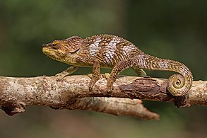 Amber Mountain chameleon, male
_male_2.jpg)
_female.jpg)
_male_2.jpg)
_female_2.jpg)
_male_Montagne_d%E2%80%99Ambre_2.jpg)
See also
- List of national parks of Madagascar
- Amber Forest Reserve
References
- ^ a b c d e "Amber Mountain National Park". Madagascar Travel Guide. Retrieved 29 October 2016.
- ^ ISBN 0-8160-2403-0.
- ^ "Madagascar Copal". Retrieved 2020-04-04.
- ^ "Monticola erythronotus". IUCN Red List of Threatened Species. Retrieved 29 October 2016.
Sources
| Strict Nature Reserves |  | |
|---|---|---|
| National parks |
| |
| Marine National Parks | ||
| Special Reserves | ||
| Other protected areas | ||