
Montauk, New York
Montauk, New York | |
|---|---|
2020) | |
| • Total | 4,318 |
| • Density | 233.53/sq mi (90.17/km2) |
| Time zone | UTC−05:00 (Eastern (EST)) |
| • Summer (DST) | UTC−04:00 (EDT) |
| ZIP Code | 11954 |
| Area code(s) | 631, 934 |
| FIPS code | 36-48054 |
| GNIS feature ID | 957540[2] |
| Website | ehamptonny |
Montauk (
The CDP encompasses an area that stretches approximately 13 miles (21 km) from Napeague, New York, to the easternmost tip of New York State at Montauk Point Light. The hamlet encompasses a small area about halfway between the two points.
Located at the tip of the South Fork peninsula of Long Island, 118 miles (190 km) east of Midtown Manhattan, Montauk has been used as an Army, Navy, Coast Guard, and Air Force base. The Montauk Point Light was the first lighthouse in New York state and is the fourth oldest active lighthouse in the United States.
Montauk is a major tourist destination with six state parks. It is particularly famous for its fishing, claiming to have more world saltwater fishing records than any other port in the world.[4] Located 20 miles (32 km) off the Connecticut coast, it is home to the largest commercial and recreational fishing fleet in New York state.[5]
History
17th century
Montauk derives its name from the Montaukett tribe, an Algonquian-speaking tribe who lived in the area. In 1614, Dutch explorer Adriaen Block encountered the tribe at Montauk Point, which he named Hoeck van de Visschers, or "Point of the Fishers".[6] Two decades later, in 1637, the Montauketts sided for their own protection with the New England settlers in the Pequot War in Connecticut. In the aftermath the Montauketts were to sell Gardiners Island. In 1648 what would become the Town of Easthampton[7] (first Maidstone) was sold to settlers by the colony of Connecticut and the colony of New Haven while retaining the lands to the east, from the hills rising above where the first fort stood (Napeague, New York) to Montauk Point. The western boundary of today's Hither Hills State Park is also known as the 1648 purchase line.[citation needed]
In 1653, the Narragansett-Montaukett War started. Narragansetts under Ninigret attacked and burned the Montaukett village, killing 30 and capturing one of Chief Wyandanch's daughters. The daughter was recovered with the aid of Lion Gardiner (who in turn was given a large portion of Smithtown, New York in appreciation). The Montauketts, ravaged by smallpox and fearing extermination by the Narragansetts, were provided temporary refuge by white settlers in East Hampton. Many short but famous battles ensued.[8] The skirmishes ended in 1657. Fort Pond Bay derives its name from a Montaukett "fort" on its shore. A deed was issued in 1661 titled "Ye deed of Guift" which granted all of the lands east of Fort Pond to be for the common use of both the indigenous people and the townsmen.[9]
Further purchase agreements were entered into in 1661, 1672 and 1686 which, among other things, allowed a group of Easthampton townsmen to graze cattle on the Montaukett lands. While some lands were protected in the agreements as forest land, for the most part, all of Montauk was maintained by the townsmen as a private livestock and fisheries operation. As a result of Montauk being operated as a livestock operation, it is considered to be the oldest
In 1660, Wyandanch's widow sold all of Montauk from Napeague to the tip of the island for 100 pounds to be paid in 10 equal installments of "
In 1686,

18th century
During the Siege of Boston in the Revolutionary War, a British ship visited Fort Pond Bay in 1775 in search of provisions—notably cattle. John Dayton, who had limited troops at his disposal on a hill above the bay, feigned that he had more by walking them back and forth across a hill turning their coats inside out to make it look like there were more of them (a tactic referred to as "Dayton's Ruse").[12]
In 1781, the British HMS Culloden ran aground near what today is called Culloden Point while pursuing a French frigate. The ship was scuttled, but its remains were discovered in the 1970s. It is now on the National Register of Historic Places and is the only underwater park in the state of New York.[citation needed]
The first hamlet of Montauk was built on Fort Pond Bay near what is now the train station for the Long Island Rail Road.[citation needed]
In 1792, Congress authorized construction of the
19th century
_restored.jpg)
.jpg)
In 1839, slaves who had seized the schooner La Amistad came ashore in the hamlet looking for provisions after being told by the white crew they had returned to Africa. American authorities were alerted, and the slaves were recaptured and ultimately freed in a historically significant trial.[citation needed]
A judgment was entered in 1851 against the Trustees of the Freeholders and Commonalty of the Town of Easthampton, and on March 9, 1852, a deed to Montauk was given to plaintiffs Henry P. Hedges and others, because their predecessors had contributed the money to purchase Montauk from the native Montaukett Indians in the 1600s. This deed caused the lands covered by the Dongan Patent to be split, leaving the still unsettled lands at Montauk without government. Less than one month later, on April 2, 1852, a state law was passed that incorporated the Proprietors Montauks, establishing the corporation of the trustees of Montauk and affirming its right to govern.[citation needed]
Stephen Talkhouse was displayed in 1867 by P. T. Barnum as "the last king of the Montauks." Talkhouse became famous for his walks from Indian Fields to New York City.[citation needed]
In 1879, Arthur W. Benson paid US$151,000 for 10,000 acres (40 km2) for the east end. The deed releasing claim to Montauk was entered on March 9, 1852. Benson also received clear title to the Montaukett property at Big Reed Pond, buying it from tribesmen for $10 each, and in one case one of the tribesmen's houses was burned down. The legitimacy of the transaction is still being contested in court by the tribe. Construction began in 1882 on seven Shingle-style "cottages" designed by Stanford White, which were the centerpiece of Benson's plans. The most prominent of the six Montauk Association houses is Tick Hall, which was owned by entertainer Dick Cavett from 1967 to October 2021, when he sold it for $23.6 million.[13]
The first train from the Austin Corbin extension of the Long Island Rail Road pulled into Montauk in 1895, the land having been bought in 1882. Corbin planned to turn Montauk into a "shortcut", saving a day each way for voyages between New York City and London: ships would dock at the Fort Pond Bay terminal and passengers would travel by rail to New York City at 60 miles per hour (97 km/h)). Corbin built the dock on Fort Pond Bay, but the plans never materialized when, among other things, Fort Pond Bay was found to be too shallow and rocky to handle oceangoing ships.[citation needed]
In 1898, after the Benson/Corbin plan did not work out as planned, the
20th century
Early 20th century
In 1924,
In 1926,
In the
Mid 20th century
During
In 1951, sport fisherman Frank Mundus began to lead charter fishing trips out of Lake Montauk, initially looking for bluefish but soon found fishing for sharks was more lucrative. The sport of "monster fishing" became Montauk's signature draw.
On September 1, 1951, the Pelican, captained by Eddie Carroll, capsized in the shoals off Montauk Point, resulting in the deaths of 45 passengers and crew. The 42-foot (13 m) Pelican was carrying 64 people, most of whom had taken the Fisherman's Special trains to the Montauk LIRR station from New York City. The boat left the Fishangrila Dock at Fort Pond Bay at 7:30 a.m., severely overloaded. After fishing in the Atlantic Ocean on the south side of Montauk for several hours, it returned home, encountering engine trouble on the way. The weather turned stormy, and a northeast wind developed against an outgoing tide, resulting in standing waves of several feet at Endeavor Shoals, just off the Point. The vessel, wallowing in the heavy seas, became unstable in its overloaded state, capsized and then foundered at 2:10 p.m. Nearby vessels were only able to rescue 19 passengers. The wreck was secured by fabled sport fisherman Frank Mundus and towed into Lake Montauk by the Coast Guard. As a result of the disaster, strict new regulations regarding overloading of fishing vessels were adopted nationwide.[15]
In 1957, the Army closed Camp Hero, and it was taken over by the United States Air Force, which in 1958 built a 100-foot-wide (30 m) AN/FPS-35 radar. A massive building was erected to house its computers.

Late 20th century
In 1959, following the
In 1967, the United States Coast Guard announced plans to tear down the Montauk Lighthouse and replace it with a taller steel tower. Erosion had reduced its buffer from the edge of a cliff from 300 feet (91 m) when it was built to less than 100 feet (30 m). After protests, the Coast Guard backed down from the plan. In 1982, the Air Force base formally closed, and the military began selling its surplus property.
Montauk Friends of Olmsted Parks LLC was established in 1994 to protect an extensive system of beaches and waterfront properties and roadways.
In 1995, Montauk became the birthplace of the extreme surfcasting technique known as skishing. The sport involves donning a wetsuit and flippers and swimming into the ocean with rod and reel to catch fish while drifting offshore.[16][17][18]
21st century

In October 2007, a fishing boat dragged up a large 19th-century anchor, which was speculated to have been lost by the SS Great Eastern in 1862.[19] In 2008, an unidentifiable carcass known as the "Montauk Monster" was discovered near the hamlet's business district, with much speculation as to its identity. In August 2016 OCEARCH designated the waters off of Montauk and the rest of the South Shore of Long Island as a birthing ground for great white sharks.
Geography
According to the United States Census Bureau, the hamlet has a total area of 19.8 square miles (51 km2), of which 17.5 square miles (45 km2) is land and 2.3 square miles (6.0 km2), or 11.53%, is water.
Climate
Montauk has a humid subtropical climate (Cfa), under the Köppen climate classification, and using the 0 °C (32 °F) isotherm, is one of the northernmost locations in North America with this climate type. The presence of the Atlantic Ocean brings warmer winters than inland areas of the same latitude as well as cooler springs and summers: despite an extensive urban heat island and warmer lows throughout much of the year, Central Park in Manhattan, as compared to Montauk, averages twice as many days with a low reaching 10 °F (−12 °C) or below.[20] The monthly daily average temperature ranges from 34.4 °F (1.3 °C) in January to 74.0 °F (23.3 °C) in July. There is 44.31 inches (1,130 mm) of precipitation annually, with a slight dry season in summer and wet season in late fall and early winter. Montauk's warm subtropical climate makes it a popular vacation destination in the winter for New Yorkers and people from upstate New York.
According to the United States Department of Agriculture's Agricultural Research Service, Montauk is in Plant Hardiness Zone 7b/8a, with an annual average extreme minimal temperature of 10 degrees Fahrenheit, which allows subtropical plants to grow that would otherwise only be able to grow in the Deep South.[21]
| Climate data for Montauk Airport, New York, 1991–2020 normals, extremes 1998–present | |||||||||||||
|---|---|---|---|---|---|---|---|---|---|---|---|---|---|
| Month | Jan | Feb | Mar | Apr | May | Jun | Jul | Aug | Sep | Oct | Nov | Dec | Year |
| Record high °F (°C) | 64 (18) |
64 (18) |
71 (22) |
89 (32) |
88 (31) |
92 (33) |
98 (37) |
98 (37) |
91 (33) |
84 (29) |
76 (24) |
70 (21) |
98 (37) |
| Mean maximum °F (°C) | 55.7 (13.2) |
54.0 (12.2) |
61.3 (16.3) |
70.8 (21.6) |
80.1 (26.7) |
86.0 (30.0) |
90.9 (32.7) |
88.5 (31.4) |
82.9 (28.3) |
75.5 (24.2) |
66.4 (19.1) |
60.3 (15.7) |
92.1 (33.4) |
| Mean daily maximum °F (°C) | 39.6 (4.2) |
40.5 (4.7) |
45.8 (7.7) |
55.0 (12.8) |
64.4 (18.0) |
74.2 (23.4) |
80.3 (26.8) |
79.6 (26.4) |
73.1 (22.8) |
63.3 (17.4) |
53.5 (11.9) |
45.3 (7.4) |
59.5 (15.3) |
| Daily mean °F (°C) | 33.7 (0.9) |
34.3 (1.3) |
39.5 (4.2) |
48.1 (8.9) |
57.0 (13.9) |
66.9 (19.4) |
73.2 (22.9) |
72.9 (22.7) |
66.7 (19.3) |
57.1 (13.9) |
47.6 (8.7) |
39.4 (4.1) |
53.0 (11.7) |
| Mean daily minimum °F (°C) | 27.7 (−2.4) |
28.1 (−2.2) |
33.2 (0.7) |
41.2 (5.1) |
49.6 (9.8) |
59.6 (15.3) |
66.2 (19.0) |
66.2 (19.0) |
60.4 (15.8) |
51.0 (10.6) |
41.6 (5.3) |
33.6 (0.9) |
46.5 (8.1) |
| Mean minimum °F (°C) | 11.3 (−11.5) |
14.1 (−9.9) |
19.7 (−6.8) |
30.1 (−1.1) |
38.9 (3.8) |
49.5 (9.7) |
58.9 (14.9) |
56.7 (13.7) |
49.5 (9.7) |
39.6 (4.2) |
28.1 (−2.2) |
20.5 (−6.4) |
9.4 (−12.6) |
| Record low °F (°C) | 5 (−15) |
−2 (−19) |
8 (−13) |
25 (−4) |
31 (−1) |
43 (6) |
51 (11) |
54 (12) |
39 (4) |
30 (−1) |
19 (−7) |
12 (−11) |
−2 (−19) |
| Average precipitation inches (mm) | 3.63 (92) |
3.20 (81) |
4.18 (106) |
3.66 (93) |
3.19 (81) |
3.50 (89) |
2.81 (71) |
4.02 (102) |
3.64 (92) |
4.22 (107) |
3.91 (99) |
4.35 (110) |
44.31 (1,123) |
| Average precipitation days (≥ 0.01 in) | 12.2 | 9.9 | 10.0 | 11.2 | 11.9 | 10.3 | 8.7 | 9.4 | 9.8 | 10.5 | 9.9 | 11.2 | 125.0 |
| Source 1: NOAA[22] | |||||||||||||
| Source 2: National Weather Service (mean maxima/minima 2006–2020)[23] | |||||||||||||
Demographics
| Census | Pop. | Note | %± |
|---|---|---|---|
| 2020 | 4,318 | — | |
| U.S. Decennial Census[24] | |||
As of the
There were 1,593 households, out of which 26.9% had children under the age of 18 living with them, 47.0% were married couples living together, 8.7% had a female householder with no husband present, and 37.7% were non-families. 28.6% of all households were made up of individuals, and 10.2% had someone living alone who was 65 years of age or older. The average household size was 2.41 and the average family size was 2.90.[28]
In the CDP, the population was spread out, with 20.0% under the age of 18, 6.6% from 18 to 24, 33.9% from 25 to 44, 25.0% from 45 to 64, and 14.5% who were 65 years of age or older. The median age was 39 years. For every 100 females, there were 105.4 males. For every 100 females age 18 and over, there were 109.2 males.[28]
The median income for a household in the CDP was $42,329, and the median income for a family was $50,493. Males had a median income of $40,063 versus $28,299 for females. The
Economy

Tourism
Montauk is considered a
The
Lake Montauk, a small bay on the north side of town, is home to a US Coast Guard station and a small fishing fleet, both commercial and recreational.
In 2007, Newsday listed 47 businesses in the category of "Hotel" in Montauk. They represented 2,030 rooms.[29]
Montauk is a favored destination for weekend partiers who, as of 2015, had exceeded the local inhabitants' tolerance for noise and disruption.[30]
Parks and recreation
Montauk's six state parks, from west to east, are:

- Hither Hills State Park
- Shadmoor State Park
- Montauk Downs State Park
- Amsterdam Beach State Park
- Camp Hero State Park
- Montauk Point State Park
In addition, there is
Notable people
- Edward Albee (1928 – 2016), Pulitzer Prize-winning playwright, who died in 2016 in his home there
- Peter Beard (1938 – 2020), photographer
- Perry B. Duryea Jr. (1921–2004), politician
- Tor Lundvall (born 1968), artist and musician
- Bernie Madoff (1938 – 2021), investment banker, fraudster, convicted felon, world's largest Ponzi scheme operator[31]
- Fred Melamed (born 1956), actor
- Paul Simon (born 1941), singer and songwriter[32]
- Toots Thielemans (1922 – 2016), jazz musician
- Rufus Wainwright (1973), singer-songwriter
- Andy Warhol (1928 – 1987), artist and entrepreneur, bought the Church Estate in Montauk − also known as Eothen − in 1972
- Tuesday Weld (born 1943), actress[33]
- Pinchas Zukerman (born 1948), conductor
- Chris Clemence (born 1986), tattoo artist and songwriter
In popular culture
Films

- 1964 – The science fiction thriller The Flesh Eaters began shooting on location in Montauk in 1962, when exterior sets and equipment suffered extensive damage from Hurricane Alma, halting production. Shooting was delayed for nearly a year while the producers regrouped to meet the escalating budget. The film was finally released on March 18, 1964.
- 1975 – The character Quint from the movie Jaws, played by Robert Shaw, was based on Frank Mundus, a shark hunter from Montauk. In the movie, Quint mentions he "caught a 16-footer [shark] off of Montauk."
- 1979 – Cocaine Cowboys was based almost entirely in Montauk, including at Andy Warhol's mansion.
- 1982 – In the film Deathtrap, thriller playwright Sidney Bruhl, played by Michael Caine, lives on Montauk, which he calls "the end of the line. Bloody symbolic."
- 1997 – Montauk is an important location in the film Commandments.
- 2004 – Montauk plays a prominent role in the film Eternal Sunshine of the Spotless Mind.
- 2009 – Montauk is the setting for the movie Paper Man starring Jeff Daniels and Ryan Reynolds.
- 2013 – Montauk is a major setting of the film Peeples.
- 2017 – The plot of the film Return to Montauk was inspired by Max Frisch's 1975 novel Montauk.
- 2017 – The fictional St. Martin's Orphanage in Death Note is in Montauk.
- 2023 – The film No Hard Feelings is set in Montauk.
Television
- 1991 – In the debut episode of Fishing with John, host John Lurie takes guest Jim Jarmusch off the coast of Montauk to catch a shark.
- 1997 – In the episode "The One at the Beach" in season 3 of the American sitcom Friends, the six friends go to Montauk to find out more about Phoebe Buffay's birth mother.
- 2007 – Montauk is the main setting of episode 208 of Engaged and Underage on MTV, with Maribel and Julio working, residing, and getting married in the town.[34]
- 2011–15 – The fictional bar "The Stowaway" in Montauk is a central location in the TV series Revenge.
- 2012 – The first episode of the reality TV series Hotel Impossible features Gurney's Inn in Montauk.
- 2014–19 – The Showtime TV series The Affair is set in Montauk.
- 2016–present: Montauk was the original title and setting of the Duffer Brothers.
- 2017 – The first season of the
Music
- 1975–76 – The Rolling Stones stayed at Andy Warhol's estate in Montauk when they were on tour in 1975–76. The Memory Motel was said to be the only place in the area, at the time, with a pool table and a piano, and the Stones were said to hang out at the bar. The song "Memory Motel" was written during this period.
- 1990 – The Downeaster Alexa", from his album Storm Front, tells the story of a Long Island fisherman's journey from Montauk through Block Island Sound on his ship.
- 2003 – Long Island indie rock band Play Crack the Sky", of their album Deja Entendu.
- 2005 – Circa Survive has a song titled "Meet Me in Montauk" from their album Juturna
- 2005 – Ryan Star's song "Losing Your Memory", from the album 11:59, references Montauk to demonstrate he still thinks of the girl he left behind.
- 2005 – Bayside, a punk band from Queens, has a song entitled "Montauk".
- 2008 – The trance group Signalrunnersreleased a song entitled "Meet Me in Montauk"
- 2012 – Rufus Wainwright wrote a song called "Montauk" which is dedicated to his daughter Viva and appears on his album Out of the Game.
Literature
- 1975 – Montauk is a novel by the Swiss writer Max Frisch which centers on the narrator's open relationship with Lynn, an American journalist; the novel inspired the 2017 film Return to Montauk.
- 1992 – Long Island residents Preston B. Nichols and Peter Moon wrote a science fiction novel, X-Filestelevision series.
- 2003 – In the novel The Interpreter, by Suki Kim, the female protagonist Suzy Park visits Montauk, where the ashes of her parents have been committed to the sea.
- 2005 – Percy Jackson and his mother visit Montauk on vacation and are attacked by a Minotaur there in the fantasy-adventure novel The Lightning Thief.
- 2013 – Montauk is the subject of a conspiracy theory in Thomas Pynchon's novel Bleeding Edge.
Comics
- 1968 – present The fictional Legion Academy, a training center for super-powered individuals run by the Legion of Super-Heroes in the 30th and 31st Centuries of the DC Universe is at Montauk Point.
Gallery
-
 Montauk's old LIRR station house, now an art gallery
 -
 The Montauk Community Presbyterian Church was built in 1927
 -

-
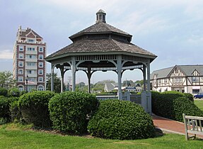 The gazebo on The Plaza.
Note the Tudor Revival architecture on the buildings behind it to the right, and the Tower at Montauk to the left. -
 The Tower at Montauk, originally the Carl Fisher Office Building


References
- ^ "ArcGIS REST Services Directory". United States Census Bureau. Retrieved September 20, 2022.
- ^ "Montauk". Geographic Names Information System. United States Geological Survey, United States Department of the Interior.
- ^ "Geographic Identifiers: 2010 Demographic Profile Data (G001): Montauk CDP, New York". U.S. Census Bureau, American Factfinder. Archived from the original on February 12, 2020. Retrieved January 3, 2013.
- ^ Rattiner, Dan (June 8, 2007). "Sharks to Vote?". Dan's Papers. Archived from the original on September 27, 2007. Retrieved January 30, 2010.
- ^ "Long Island Fishing Charters And Party Boats". NY Fisherman. Retrieved April 17, 2010.
- ^ Wick, Steve. "Property of the Netherlands". Newsday. Archived from the original on December 17, 2004.
- ^ 1686 Dongan Patent[full citation needed]
- ^ The Narragansetts "would have exterminated the whole Montauk tribe if they had not received help from the white settlers.” Cited in "Long Island Indians and The Early Settlers". Long Island Genealogy. Retrieved April 27, 2013.
- ^ "Ye Deed of Guift", 1661, pp. 11–19
- ^ Thompson, Benjamin Franklin (1839). History of Long Island; Containing an Account of the Discovery and Settlement; with Other Important and Interesting Matters to the Present Time. New York: E. French. p. 185. Retrieved April 17, 2010.
- ^ The Material History of the Montaukett, lecture by Gaynell Stone, East Hampton Public Library, January 31, 1998 Archived December 7, 2006, at the Wayback Machine
- ^ Mead, Julia C. (January 15, 1998). "An Old Dayton House Saved From Bulldozer". The East Hampton Star. Archived from the original on November 11, 2009. Retrieved January 30, 2010.
- ^ Holmberg, Anikka (October 23, 2011). "Dick Cavett Sells Legendary Montauk Home Known As Tick Hall for $23.6M". Cottages & Gardens. Archived from the original on November 19, 2021. Retrieved October 11, 2022.
- ^ a b Tuma, Debbie (August 11, 2002). "Montauk Embraces Its Legacy". The New York Times.
- ISBN 0-07-148659-3.
- ^ Rhoads, Christopher (July 26, 2010). "Swimming With The Fishes: Angler's Tangle Over 'Skishing'". The Wall Street Journal.
- ^ Burke, Monte (October 27, 2005). "Skishing". Forbes.
- ^ DeBenedetto, David (September 16, 2003). "Swimming With the Fishes". On The Run: An Angler's Journey Down Striper Coast.
- ^ Rattiner, Dan (October 19, 2007). "Great Eastern? Anchor from One of the World's Largest Ships Is Hauled Up off Montauk". Dan's Papers. Archived from the original on January 8, 2009. Retrieved February 11, 2010.
- ^ "Station Name: NY NEW YORK CNTRL PK TWR". National Oceanic and Atmospheric Administration. Retrieved June 27, 2013.
- ^ "Annual Average Extreme Minimal Temperature, 1976-2005" USDA Agricultural Research Service
- ^ "U.S. Climate Normals Quick Access – Station: Montauk AP, NY". National Oceanic and Atmospheric Administration. Retrieved September 14, 2023.
- ^ "NOAA Online Weather Data – NWS New York". National Weather Service. Retrieved September 14, 2023.
- ^ "Census of Population and Housing". Census.gov. Retrieved June 4, 2016.
- ^ "U.S. Census website". US Census Bureau. Retrieved November 16, 2016.
- ^ a b c d "Profile of General Population and Housing Characteristics: 2010 more information 2010 Demographic Profile Data". US Census Bureau. Retrieved November 16, 2016.
- ^ "Montauk, New York". City-data.com. Retrieved November 16, 2016.
- ^ a b c "U.S. Census website". United States Census Bureau. Retrieved January 31, 2008.
- ^ Newsday article
- ^ Rutenberg, Jim (August 28, 2015). "The Battle for the Soul of the Hamptons". The New York Times. Retrieved August 30, 2015.
...a new horde of speculators (moguls, nightclub impresarios and their yearly multiplying conspicuous consumers) drives and flies ever eastward from Manhattan toward that beguiling jewel of Long Island, the Hamptons.
- ^ Paynter, Sarah (March 20, 2023) "Bernie Madoff’s Former Hamptons Home Sells for $14 Million" The Wall Street Journal
- Patch, August 28, 2018
- ^ Laura Euler (September 17, 2021). "Tuesday Weld Scoops Up Compact Hamptons Condo". Yahoo!.
- ^ Full episode on MTV.com
- ^ Peterson, Oliver (December 8, 2016). "Rent Bravo's Summer House Near Montauk for $165,000". danspapers.com. Retrieved June 26, 2017.
- ^ http://www2.census.gov/geo/maps/dc10map/GUBlock/st36_ny/place/p3649424_napeague/DC10BLK_P3649424_001.pdf [bare URL PDF]
External links
| International | |
|---|---|
| National | |
| Geographic | |
| Other | |