
Monywa
This article needs additional citations for verification. (May 2019) |
Monywa
မုံရွာမြို့ | |
|---|---|
City | |
MST) | |
| Area code | 71[2] |
Monywa (Burmese: မုံရွာမြို့; MLCTS: muṃ rwa mrui.; pronounced [mòʊɰ̃jwà mjo̰]) is the largest city in Sagaing Region, Myanmar, located 136 kilometres (85 mi) north-west of Mandalay on the eastern bank of the River Chindwin. Monywa is one of the largest economic cities in Myanmar. It is also known as 'Neem City' because many of the city's streets are lined with neem trees.[citation needed]
Climate
Monywa and neighbouring parts of the “Dry Valley” are the only places in Southeast Asia where the hot semi-arid climate (Köppen BSh) occurs.[3][4] The city misses the tropical savanna climate (Köppen Aw) classification due to the very high temperatures and resultant high evaporation levels, alongside a long dry season. The semi-aridity has to do with the “Dry Valley” being located in the rain shadow of the Arakan Mountains. Temperatures are very high throughout the year, although the winter months from December to February are significantly milder at around 21 °C or 69.8 °F in January. The early monsoon months from April to July are especially hot, with average high temperatures reaching 38.4 °C (101.1 °F) in April.
Monywa received 139 millimetres or 5.47 inches of rainfall on 19 October 2011. This was a new record for rainfall within 24 hours in October in Monywa for the last 47 years. The previous record was 135 millimetres or 5.31 inches on 24 October 1967.[5]
| Climate data for Monywa (1991–2020) | |||||||||||||
|---|---|---|---|---|---|---|---|---|---|---|---|---|---|
| Month | Jan | Feb | Mar | Apr | May | Jun | Jul | Aug | Sep | Oct | Nov | Dec | Year |
| Record high °C (°F) | 34.6 (94.3) |
39.3 (102.7) |
42.4 (108.3) |
44.0 (111.2) |
45.8 (114.4) |
43.5 (110.3) |
42.0 (107.6) |
41.0 (105.8) |
38.9 (102.0) |
38.8 (101.8) |
37.4 (99.3) |
34.0 (93.2) |
45.8 (114.4) |
| Mean daily maximum °C (°F) | 29.2 (84.6) |
33.0 (91.4) |
37.0 (98.6) |
39.4 (102.9) |
38.1 (100.6) |
36.4 (97.5) |
36.2 (97.2) |
35.0 (95.0) |
34.1 (93.4) |
32.9 (91.2) |
31.3 (88.3) |
28.9 (84.0) |
34.3 (93.7) |
| Daily mean °C (°F) | 21.5 (70.7) |
24.4 (75.9) |
28.2 (82.8) |
31.4 (88.5) |
31.7 (89.1) |
31.1 (88.0) |
31.1 (88.0) |
30.3 (86.5) |
29.5 (85.1) |
28.2 (82.8) |
25.4 (77.7) |
22.1 (71.8) |
27.9 (82.2) |
| Mean daily minimum °C (°F) | 13.9 (57.0) |
15.8 (60.4) |
19.4 (66.9) |
23.5 (74.3) |
25.4 (77.7) |
25.9 (78.6) |
25.9 (78.6) |
25.5 (77.9) |
24.9 (76.8) |
23.5 (74.3) |
19.5 (67.1) |
15.3 (59.5) |
21.5 (70.7) |
| Record low °C (°F) | 7.2 (45.0) |
11.0 (51.8) |
14.2 (57.6) |
17.1 (62.8) |
17.2 (63.0) |
20.2 (68.4) |
23.1 (73.6) |
21.0 (69.8) |
20.4 (68.7) |
17.6 (63.7) |
12.0 (53.6) |
8.3 (46.9) |
7.2 (45.0) |
| Average precipitation mm (inches) | 2.9 (0.11) |
1.3 (0.05) |
7.0 (0.28) |
31.5 (1.24) |
97.5 (3.84) |
80.6 (3.17) |
62.4 (2.46) |
121.6 (4.79) |
172.3 (6.78) |
135.8 (5.35) |
23.3 (0.92) |
3.6 (0.14) |
739.8 (29.13) |
| Average precipitation days (≥ 1.0 mm) | 0.4 | 0.5 | 0.8 | 3.4 | 8.5 | 6.6 | 6.3 | 9.3 | 10.3 | 8.8 | 1.9 | 0.7 | 57.5 |
| Source 1: World Meteorological Organization[6] | |||||||||||||
| Source 2: Norwegian Meteorological Institute (extremes),[7] Ogimet.com[8] | |||||||||||||
Culture
Monywa is a national hub for poets, and is often described as the centre of poetry in Upper Myanmar. The town has served as home to many contemporary poets, including Min Swe Hnit, K Za Win, Kyi Zaw Aye, and Khat Thi.
Transport

Monywa is served by the Mandalay-
Economy


Monywa is a major centre for
Black market goods from India, especially saris and bicycle parts, pass through Monywa on their way to other parts of Myanmar.
Attractions

The major
Another attraction is the Phowintaung cave complex across the Chindwin River, approximately 25 kilometres (16 mi) west of Monywa.
Nyaung-gan Bronze Age cemetery, dated to between 1,500 BCE and 500 BCE, in Budalin with bronze tools, ceramics and stone artifacts is 60 minutes travel on a narrow road north of Monywa.[14]
Very few tourists visit Monywa as its facilities are limited.
Education

The city is home to several higher education institutions:
- Monywa University
- Monywa Education College
- Monywa University of Economics
- Technological University, Monywa[15]
- Computer University, Monywa[16]
Healthcare
Monywa has two public hospitals:
- Monywa General Hospital
- Monywa Women and Children Hospital
Politics
The insurgent
Notable residents
- Thant Sin Maung
- Tun Kyi
- Kyaw Hsan
- U Lu Tin
Gallery
-
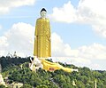 Giant reclining Buddha at Bodhi Tahtaung
 -
 Shwezigon-Paya
 -
 Aung Setkya Paya
.jpg)


Notes
- ^ The 2014 Myanmar Population and Housing Census The Union Report Census Report Volume 2. Department of Population, Ministry of Immigration and Population. May 2015. p. 52. Archived from the original on 2016-03-06. Retrieved 2018-09-06.
- ^ "Myanmar Area Codes". Archived from the original on 2009-12-01. Retrieved 2009-04-10.
- ^ Brzezina, Jachym. "Meteotemplate". Meteotemplate.
- ^ "Myanmar climate: Average Temperature, weather by month, Myanmar weather averages – Climate-Data.org". en.climate-data.org.
- ^ http://www.mrtv3.net.mm/newpaper/2110newsm.pdf[permanent dead link] Page 19 Col 2
- ^ "World Meteorological Organization Climate Normals for 1991–2020". World Meteorological Organization. Retrieved 16 October 2023.
- ^ "Myanmar Climate Report" (PDF). Norwegian Meteorological Institute. pp. 23–36. Archived from the original (PDF) on 8 October 2018. Retrieved 28 October 2018.
- ^ "48037: Monywa (Myanmar)". ogimet.com. OGIMET. 15 October 2021. Retrieved 15 October 2021.
- The New Light of Myanmar, December 3, 2002. Archived from the originalon 2009-02-28. Retrieved 2008-10-12.
- ^ "Chindwin River". Encyclopædia Britannica online. Retrieved 2008-10-12.
- ^ "Monywa Airport Profile | CAPA". centreforaviation.com.
- ^ Sandar Lwin (21 March 2011). "In Monywa, 'market economy' leaves some businesses behind". Myanmar Times. Archived from the original on 16 September 2011. Retrieved 23 August 2011.
- ^ "Nev World Wonders". Archived from the original on 2015-09-18. Retrieved 2011-12-29.
- ^ Once feted by Myanmar's junta, Bronze Age cemetery site returns to the spotlight, Forntier Myanmar.
- ^ "Ministry of Science and Technology". MOST, February 2009. Archived from the original on 2009-02-25. Retrieved 2009-04-14.
- ^ "Ministry of Science and Technology". MOST, February 2009. Archived from the original on 2011-07-19. Retrieved 2009-04-14.
External links
- City of Monywa Archived 2011-01-17 at the Wayback Machine
- Burman photograph album 1897 Old photos of Monywa
- Chindwin River - lifeblood of upper Sagaing Myanmar Times, January 16–22, 2006
Capital: Monywa | ||
| Hkamti District |
| .svg)  |
| Homalin District | ||
| Kale District |
| |
| Kanbalu District | ||
| Katha District | ||
| Kawlin District |
| |
| Mawlaik District | ||
| Monywa District | ||
| Naga Self-Administered Zone |
| |
| Sagaing District |
| |
| Shwebo District | ||
| Tamu District |
| |
| Ye-U District |
| |
| Yinmabin District |
| |
| 2,000,000 and more | |
|---|---|
| 1,000,000–1,999,999 | |
| 500,000–999,999 |
|
| 200,000–499,999 | |
| 100,000–199,999 | |
| International | |
|---|---|
| National | |