
Morava (river)
| Morava | ||
|---|---|---|
State (AT) Lower Austria | | |
| Cities | ||
| Physical characteristics | ||
| Source | ||
| • location | Králický Sněžník | |
| • coordinates | 50°12′18″N 16°50′57″E / 50.20500°N 16.84917°E | |
| • elevation | 1,275 m (4,183 ft)[1] | |
| Mouth | Danube | |
• location | Devín | |
• coordinates | 48°10′27″N 16°58′32″E / 48.17417°N 16.97556°E | |
| Length | 352 km (219 mi)[2] | |
| Basin size | 26,658 km2 (10,293 sq mi)[2] | |
| Discharge | ||
| • location | mouth | |
| • average | 110 m3/s (3,900 cu ft/s)[2] | |
| Basin features | ||
| Progression | Danube→ Black Sea | |
| Tributaries | ||
| • left | Krupá, Branná, Desná, Oskava, Bečva, Dřevnice, Olšava, Velička, Myjava | |
| • right | Mírovka, Moravská Sázava, Haná, Thaya | |
The Morava (German: March, Hungarian: Morva, Polish: Morawa) is a river in Central Europe, a left tributary of the Danube. It is the main river of Moravia, which derives its name from it. The river originates on the Králický Sněžník mountain in the north-eastern corner of Pardubice Region, near the border between the Czech Republic and Poland and has a vaguely southward trajectory. The lower part of the river's course forms the border between the Czech Republic and Slovakia and then between Austria and Slovakia.
Etymology
Though the German name March may refer to Mark, "border, frontier" (cf. English march), the river's name more probably is derived from Proto-Indo-European *mori, "waters" (mare), according to Bulgarian linguist Vladimir I. Georgiev. It was first documented as Maraha in an 892 deed.
History
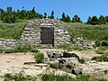
The shores of the Morava have been inhabited for a very long time. The village of Stillfried, on the Austrian part of the river, was the location of a human settlement already 30,000 years ago.[1] Agriculture began to be practiced in the Morava valley approximately 7,000 years ago, and fortified settlements began to appear during the New Stone Age.[1]
The lower part of the river, downstream of the confluence with the Thaya at
In July 1997, the Morava basin (especially its northern and eastern part) was affected by heavy
History of the river
-
 Skeletons of a family (9th century BC) of the Urnfield culture site at Stillfried
 -
 An allegorical representation of Morava at Schloss Hof in Austria
 -
 The flood of 1997 in Uherské Hradiště


Course
The river originates in the Králický Sněžník mountains in north-western Moravia, not far from the border with Poland. The lowlands formed by the river are the Upper Morava Valley and then the Lower Morava Valley in Moravia, the Morava Field or Marchfeld in Lower Austria, and the Záhorie Lowland in Slovakia. The latter three are actually continuous parts of one large basin, forming the major part of the Vienna Basin.
In the Czech Republic, there are some larger towns lying upon the Morava, particularly Olomouc, Kroměříž, Otrokovice, Uherské Hradiště and Hodonín. Brno, the second largest city of Czech Republic, lies within the river basin.[1] The catchment area of the river has a population of c. 3.5 million people.[1] Downstream of Hodonín, the river flows along sparsely inhabited, forested border area, all the way to its outfall into the Danube, just below Devín Castle on the outskirts of the Slovak capital Bratislava. After 352 km (219 mi) of its course, the Morava feeds the Danube with an average discharge rate of 110 m3/s (3,900 cu ft/s), collected from a drainage area of 26,658 km2 (10,293 sq mi).[2]
The river's longest tributary by far is the Thaya (Dyje in Czech),[1] flowing in at the tripoint of Austria, the Czech Republic and Slovakia. The confluence of the Thaya and Morava is the southernmost and the lowest point of Moravia. The biggest tributary from the left is the Bečva.
The Morava is a lowland river with a basin that consists of 51% plains; mountains make up only seven percent of the basin while 35% are considered highland. The average slope of the river is 1.8‰ and at the confluence 4‰.[1] The bedrock of the river basin is mostly crystalline bedrock and flysch.[1]
The Morava is unusual in that it is a European blackwater river.
Course of the river
-
 The source of the Morava on Králický Sněžník
 -
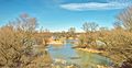
 The confluence of the Morava and the Danube
 -
 Morava in Olomouc
 -
 Thaya-Morava confluence – intersection of three borders: Austrian, Czech and Slovak
.JPG)


Ecology
The Morava river forms an important link between the Danube Valley and the plains of
Ecology of the river
-
 Flooded forest
 -
 Flooded meadow
 -
 One of many oxbow lakes of the Morava
 -
 Nature park Strážnické Pomoraví in Czech Republic, one of several protected natural areas along the Morava


See also
- March of Austria
- March of Moravia
References
- ^ ISBN 9780080919089.
- ^ a b c d "Danube River Basin District, Part A - Roof Report" (PDF). ICPDR. April 2004. p. 12.
External links
 Geographic data related to Morava (river) at OpenStreetMap
| Countries |  | |
|---|---|---|
| Cities | ||
| Tributaries | ||
| Canals | ||
| See also | ||
| International | |
|---|---|
| National | |