
Moselle
| Moselle | |
|---|---|
 Typical landscape of Moselle vineyards near Schweich | |
 Map of the Moselle River watershed | |
| Native name | |
| Location | |
| Countries |
|
| • elevation | 715 m (2,346 ft) |
| Mouth | |
• location | Rhine |
• coordinates | 50°21′58″N 7°36′25″E / 50.36611°N 7.60694°E |
| Length | 546 km (339 mi) |
| Basin size | 28,111 km2 (10,854 sq mi) |
| Discharge | |
| • average | 284 m3/s (10,000 cu ft/s) |
| Basin features | |
| Progression | Rhine→ North Sea |


,_2012-08_CN-01.jpg)


The Moselle (
Its lower course "twists and turns its way between
Name
The name Moselle is derived from the Celtic name form, Mosela, via the Latin Mosella, a diminutive form of Mosa, the Latin description of the Meuse, which used to flow parallel to the Moselle. So the Mosella was the "Little Meuse".
The Moselle is first recorded by
The
The river subsequently gave its name to two French republican
Geography

The source of the Moselle is at 715 m (2,346 ft) above sea level on the Col de Bussang on the western slopes of the Ballon d'Alsace in the Vosges. After 544 km (338 mi) it discharges into the Rhine at the Deutsches Eck in Koblenz at a height of 59 m (194 ft) above NHN sea level. The length of the river in France is 313 km (194 mi),[5] for 39 km (24 mi) it forms the border between Germany and Luxembourg, and 208 km (129 mi) is solely within Germany.
The Moselle flows through the
mountain regions.The average flow rate of the Moselle at its mouth is 328 m3/s (11,600 cu ft/s),[6] making it the second largest tributary of the Rhine by volume after the Aare (560 m3/s; 20,000 cu ft/s) and bigger than the Main and Neckar.[7]
River sections
The section of the Moselle from the France–Germany–Luxembourg tripoint near Schengen to its confluence with the Saar near Konz shortly before Trier is in Germany known (geographically incorrectly[citation needed]) as the Upper Moselle. The section from Trier to Pünderich is the Middle Moselle, the section between Pünderich and its mouth in Koblenz as the Lower Moselle or Terraced Moselle (Terrassenmosel). Characteristic of the Middle and Lower Moselle are its wide meanders cut deeply into the highlands of the Rhenish Massif, the most striking of which is the Cochemer Krampen between Bremm and Cochem. Also typical are its vineyard terraces.
From the tripoint the Moselle marks the entire Saarland–Luxembourg border.
Catchment
The catchment area of the Moselle is 28,286 km2 (10,921 sq mi) in area. The French part covers 15,360 km2 (5,930 sq mi), about 54 percent of the entire catchment. The German state of Rhineland-Palatinate has 6,980 km2 (2,690 sq mi), the Saarland 2,569 km2 (992 sq mi), Luxembourg 2,521 km2 (973 sq mi), Wallonia in Belgium 767 km2 (296 sq mi) and North Rhine-Westphalia, 88 km2 (34 sq mi).
Tributaries
The three largest
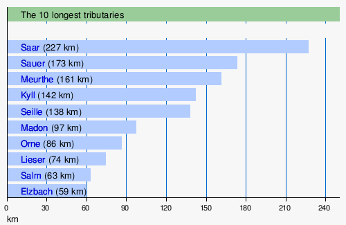


List of tributaries
- From the left
Madon, Terrouin, Esch, Rupt de Mad, Orne, Fensch, Gander, Syre, Sauer, Kyll, Salm, Lieser, Alf, Endert, Brohlbach, Elz.
- From the right
Moselotte, Vologne, Meurthe, Seille, Saar, Olewiger Bach, Avelsbach, Ruwer, Feller Bach, Dhron, Ahringsbach, Kautenbach, Lützbach, Flaumbach, Altlayer Bach, Baybach, Ehrbach.
Towns
Towns along the Moselle are:
- in France: Épinal, Toul, Pont-à-Mousson, Metz and Thionville
- in Luxembourg: Schengen, Remich, Grevenmacher and Wasserbillig
- in Germany: Konz, Trier, Schweich, Bernkastel-Kues, Traben-Trarbach, Zell, Cochem and Koblenz
Adjacent mountain ranges
From Trier downstream the Moselle separates the two
(to the southeast).Geology
The Vosges, the present source region of the Moselle, were formed about 50 million years ago. In the Miocene and Pliocene epochs the ancient Moselle (Urmosel) was already a tributary of the ancient Rhine (Ur-Rhein). When, in the Quaternary period, the Rhenish Massif slowly rose, the meanders of the Moselle were formed between the Trier Valley and the Neuwied Basin.
Water levels

The
- 11.28 m (37 ft 0 in), Trier Gauge on 21 December 1993
- 10.56 m (34 ft 8 in), Trier Gauge on 28 May 1983
- 10.33 m (33 ft 11 in), Trier Gauge on 23 January 1995
- 10.26 m (33 ft 8 in), Trier Gauge on 12 April 1983
- 9.92 m (32 ft 7 in), Trier Gauge on 27 February 1997
- 0.47 m (1 ft 7 in) in Bernkastel on 28 July 1921
History

The Moselle was known to the Romans by the name of Flumen Musalla (in the
During
On September 13, 1944, the 80th Division launched their assault accompanied by extensive artillery and air support, which helped to suppress the German defenses. The division managed to establish a foothold on the east bank of the river, securing a bridgehead at Dieulouard.
With the bridgehead secured, Combat Command A of the 4th Armored Division crossed the Moselle and advanced towards Nancy, encircling the city and cutting off German supply lines. The 80th Division continued its advance, pushing towards the northeast and engaging in fierce combat with German forces.
The operations to capture Nancy continued until September 15 when the city was liberated by the combined efforts of the 80th Infantry Division and the 4th Armored Division. The successful crossing of the Moselle River and the capture of Nancy dealt a significant blow to German defenses in northeastern France and further contributed to the Allied advance towards Germany.[8]
In the act of 10 April 1952 ratifying the treaty instituted by the
The River was canalised between
It is on the Moselle, at the site of the France–Germany–Luxembourg tripoint, that the
Economy
The Moselle valley between Metz and Thionville is an industrial area, with coal mining and steel manufacturers.
The Moselle valley is famous for its scenery and wine. Most well-known is the German
After the Second World War, France pressed to be able to ply the Moselle with larger ships in order to be able to link the industrial regions of
In 1921 the Moselle (Mo) became a Reich waterway,[13] today it is a federal waterway (Bundeswasserstraße)[14] from Apach at the tripoint to its mouth on the Rhine at kilometre point 592.29[15] in Koblenz. The waterway is 242 km (150 mi)[15] long and managed by the Trier and Koblenz Water and Shipping Offices (Wasser- und Schifffahrtsämtern Trier und Koblenz). It is categorized as a European waterway of Class Vb. Its kilometrage begins at its mouth at kilometre point 0 and runs upstream. Since 1816 it has formed a 36 km (22 mi) long[15] condominium from Apach, a common Germany–Luxembourg sovereign area with a division of responsibilities set out in a 1976 agreement. The International Moselle Company, initially set up in 1957 to finance the construction of the river's upgrade, manages the shipping charges and the operation and maintenance of the waterway which they are used to fund.

Today the Moselle is navigable for large
By 1970 more than 10 million tonnes of goods were being transported on the Moselle, the majority on towed barges. Upstream freight mainly comprised fuel and ores; downstream the main goods were steel products, gravel and rocks. There is an inland port at Trier, a transshipment site in Zell (Mosel); and there are other ports in Mertert, Thionville, Metz and Frouard. In addition to freighters there are also pleasure boats for tourists between the very busy wine villages and small towns of the Middle and Lower Moselle. There are also
Locks and dams (weirs)

There is a total of 28 changes of level on the Moselle:
- 16 in France near
- 2 between Luxembourg and Germany near Wellen
- 10 in Germany near Trier, Detzem, Wintrich, Zeltingen, Enkirch, St. Aldegund, Fankel, Müden, Lehmen and Koblenz. Detzem is the highest lock – 9 m (30 ft) – and at 29 km (18 mi) the upstream reach is the longest on the river; it is the only lock to be built on a canal of some length excavated outside the river bed.
With the exception of Detzem, all the structures at each change in level are laid out side by side; the
Tourism
Through the Moselle valley run the Moselle Wine Route and the Moselle Cycleway, which may be cycled from
A number of notable castles and ruins adorn the heights above the Moselle valley and many are visible on a boat trip on the Moselle.
In 1910, a hiking trail, the Moselle Ridgeway, was established which runs for 185 km (115 mi) on the Eifel side and 262 km (163 mi) on the Hunsrück side. Another unusual trail runs from Ediger-Eller via the Calmont Trail to Bremm through the steepest vineyard in Europe.
Before the construction of barrages the Moselle was a popular route for folding kayaks which is why many of the weirs have boat channels. The river is still used today by canoeists, especially during the annual week-long lock closures when no commercial shipping is permitted.
In April 2014 the Moselle Trail was opened, a path running for 365 km (227 mi) from Perl on the Upper Moselle to Koblenz. Numerous Moselle Trail "partner trails", the so-called side branches (Seitensprünge) and "dream paths" (Traumpfade) enhance the hiking network in the Moselle Valley.[18]
The
.At Koblenz Locks the Mosellum offers exhibitions about the migration of fish in the Moselle as well as water ecology, navigation and power generation. With the construction of the visitor and information centre the most modern fish ladder along the Moselle was opened.
Wine
The
The German Moselle wine region, including its tributaries, bears the growing and manufacturing name of "Mosel". For marketing reasons the agricultural authorities of the region have divided it into six winegrowing areas.[19] The wine literature and specialist press, by contrast, divide the region into four areas based on geomorphological, micro-climatic and also historical reasons:
- Upper Moselle
- The valley sides of the Pinot Noirgrapes.
- Trier Region
- Around the city of Ruwer with their side valleys, the Riesling is the predominant grape on the shale soils, with over 80% of the crop. One climatic feature of this area is the frequent orientation of often small southwest-southeast facing locations in which the vegetation is exposed to stronger, cooler winds and, especially in the light of recent global warming, often achieve lower degrees of maturity than in the narrow, often deeply incised valley of the Middle and Lower Moselle.[20]
- Middle Moselle
- With around 6,000 ha (15,000 acres) of vineyard the Middle Moselle is the largest winegrowing area of the Moselle. According to the wine experts and trade, the "greatest" wines of the Moselle, both in quantity and quality, are grown here on land that has been consolidated into large concerns with much vaunted steeply sloped vineyards.[21]
- Lower Moselle
- In the timber-framed houses, surrounded by steep slopes with small terraces in the narrow, winding valley. Here, cultivating vines is very labour-intensive and costly and it is difficult to make it economical. As a result, it is common for vineyards to fall into ruin here.
The wine industry on the German Moselle has been declining for decades. In 2005, statistics showed there were 10,375 ha (25,640 acres) of vineyard; by 2012 this had fallen to just 8,491 ha (20,980 acres).[22] The vineyards that have fallen fallow are mostly those on extremely steep hillsides. There has been a major decline in the number of so-called Nebenerwerbswinzer (vintners for whom it is a secondary occupation), and the small, family farming operations that, until the end of the 1960s formed the majority of wine businesses. Comparative figures by the Chamber of Agriculture for Rhineland-Palatinate for several wine villages on the Lower Moselle show that there were still 797 wine businesses in the early 1960s, but by the early 2000s there were only just under 100.
There has been the opposite trend amongst the established traditional wine estates and more recent vintners with a sound education in oenology and business management, who have increased their business through the reclamation of once renowned, but long forgotten sites. The end of the 20th century saw the rediscovery of the use of special terroir[23] in order to improve quality and value, which has led to a more nuanced view of Moselle wine that, a few years before, had been characterised by overproduction, label scandals and cheap offers.
Moselle umbrella brand
On 10 November 2006 in
Moselle slate
Moselle slate (Moselschiefer) is a manufacturing and trade description for slate from the municipalities of Mayen, Polch, Müllenbach, Trier and its surrounding area. Today only products from the roofing slate mines of Katzenberg in Mayen and Margareta in Polch bear the name Moselle Slate. The name is derived from the historical transport route for this slate along the Moselle to the Lower Rhine.
Railways
The following railway lines run or ran along the river:
- Koblenz–Trier railway (Moselstrecke), between Koblenz and Bullay, and in Trier, mostly on the left (northern) bank
- Pünderich–Traben-Trarbach railway, for its entire length, on the left (northern) bank
- Moselle Railway, between Bullay and Trier, on the right (southern) bank. Closed in the 1960s.
- Trier West Railway, between Ehrang and Igel, on the left (northern) bank
- Thionville–Trier railway (Obermoselstrecke), for its entire length, on the right (eastern) bank
- CFL line 1a, between Wasserbillig and Grevenmacher, on the left (western) bank. No passenger service remains.
- Metz–Luxembourg railway, between Thionville and Metz, mainly on the left bank
- Lérouville–Metz railway, between Metz and Novéant, mainly on the left bank
- Frouard–Novéant railway, mainly on the left bank
- Paris–Strasbourg railway, between Frouard and Toul
- Blainville-Damelevières–Lure railway, between Bayon and Épinal
- Épinal–Bussang railway, between Épinal and Remiremont, on the left bank
Literature
- Mosella, a Latin poem by Ausonius (4th century).
- In the tale, "The Seven Swabians" of the Brothers Grimm, these Swabians drown trying to cross the Moselle.
- Accounts of the river, its folklore and local history appear in Small Boat on the Moselle a 1968 book by Roger Pilkington.
Castles


- Château de Meinsberg (dit de Malbrouck): near Manderen, this castle was built in the 15th century but rebuilt in the 1990s. Today it is used for numerous cultural events.
- Vauban.
- Schloss Berg: a Renaissance castle at Nennig, today a hotel and a casino.
- Alte Burg: a manor house built in 1360 at Longuich. One of the few surviving manor houses in rural Rhineland-Palatinate.
- Lieser built from 1884 to 1887 in historistic style.
- Landshut Castle: a castle built by the Electorate of Trier in the 13th century at Bernkastel-Kues.
- Grevenburg: ruins of a castle at Traben-Trarbach built by Johann III of Sponheim-Starkenburg about 1350, destroyed, after many sieges, in 1734.
- Marienburg: a 12th-century castle and later monastery near Pünderich and Alf.
- Arras Castle: a 12th-century castle in Alf.
- Metternich Castle: a castle built around 1120 at Beilstein, today partly in ruins.
- soldiers in 1689. The present castle was rebuilt later in the 19th century.
- Thurant Castle: Above the town of Alken is Thurant Castle, built in the 13th century. It is the only twin-towered castle along the Moselle. The fortress was built by the Count Palatine Henry of the house of Guelph between 1198 and 1206. From 1246 to 1248, it was the two archbishops of Cologne and Trier. Following conquest, it was divided by a partition wall into two halves, each with a keep (tower). During the 19th century, Thurant disintegrated, becoming a ruin; and in 1911 was acquired by Privy Councilor, Dr. Robert Allmers, who had it rebuilt. Since 1973, the castle has been owned by the Allmers and Wulf families.[24]
- Ehrenburg: a 12th-century castle built by the Electorate of Trier at Brodenbach.
- Eltz Castle: The von Eltz family castle, whose history dates back to the 12th century. It remains in private hands to this day but it is open to visitors.
- Lower and Upper Castle, Kobern-Gondorf: two 11th-century castles, today mostly in ruins.
- Pyrmont Castle: This 13th-century castle near Roes was remodelled and extended several times during the Baroque era.
- Krefeld.
References
- ^ "Moselle". The American Heritage Dictionary of the English Language (5th ed.). HarperCollins. Retrieved 2019-10-01.
- ^ a b Moselle: Holidays in one of Germany's most beautiful river valleys at www.romantic-germany.info. Retrieved 23 Jan 2016.
- ^ Publius Cornelius Tacitus: Der Text ist verfügbar in der lateinischen Wikisource: Kapitel LIII, at la.wikisource.org
- ^ Publius Cornelius Tacitus: Der Text ist verfügbar in der lateinischen Wikisource; erwähnt ist die Mosel in Kapitel 71 und Kapitel 77, at la.wikisource.org
- . Retrieved 9 June 2022.
- ^ Hydrologischer Atlas der Schweiz 2002, Tab. 5.4 Natürliche Abflüsse 1961-1980 (natural discharges) (see map Archived 2011-07-07 at the Wayback Machine)
- ^ The Meuse, with a volumetric discharge of 350 m3/s (12,000 cu ft/s) is not considered, since it has not officially been a tributary of the Rhine since 1970 (although it is hydrologically).
- ^ "American Drive to the Moselle".
- ^ L'historique de la canalisation de la Moselle, par M. René Bour. pp.101 à 112
- ^ Levainville Jacques, La canalisation de la Moselle. In: Annales de Géographie. 1928, t. 37, no. 206. pp. 180–184.
- ^ "Rivière Moselle – Dictionnaire des canaux et rivières de France". Retrieved 3 May 2016.
- ^ Institut National de l’Audiovisuel – Ina.fr. "La canalisation de la Moselle". Ina.fr. Retrieved 3 May 2016.
- ^ Verzeichnis A, Lfd. Nr. 39 der Chronik Archived 2016-07-22 at the Wayback Machine, Wasser- und Schifffahrtsverwaltung des Bundes, at wsv.de
- ^ Verzeichnis E, Lfd. Nr. 34 der Chronik Archived 2016-07-22 at the Wayback Machine, Wasser- und Schifffahrtsverwaltung des Bundes, at wsv.de
- ^ a b c Gliederung Bundeswasserstraßen Archived 2016-01-21 at the Wayback Machine, mit Informationen u. a. zu Längen (in km) der Hauptschifffahrtswege (Hauptstrecken und bestimmte Nebenstrecken) der Binnenwasserstraßen des Bundes, bei der Wasser- und Schifffahrtsverwaltung des Bundes, at wsv.de
- ^ a b "Elwis database" (PDF). Archived from the original (PDF) on 2010-10-28. Retrieved 2010-03-17.
- ^ "DTNE : Direction territoriale Nord-Est VNF". Retrieved 3 May 2016.
- ^ Moselsteig entfacht das Wanderfieber. In: Trierischer Volksfreund, dated 26 September 2014. Retrieved 26 September 2014, at volksfreund.de
- ^ Von der Mehrzahl der Winzer nicht genutzte Herkunftsbezeichnung
- ISBN 978-3-502-15173-9, pp. 103 ff.
- ISBN 978-3-608-94073-2pp. 137–187
- ^ Publications by the Statistical Office of Rhineland-Palatinate.
- ^ Reinhard Löwenstein, Vom Öchsle zum Terroir, Frankfurter Allgemeine newspaper No. 232, 7 October 2003 and Die Zukunft liegt im Terroir, in the same paper dated 17 December 2005
- ^ "Burg Thurant – Wenn Sie etwas Besonderes suchen". thurant.de.
Bibliography
- Decimius Magnus Ausonius: Mosella [Description of a journey by ship on the Moselle around 371 A. D.] http://www.perseus.tufts.edu/hopper/text?doc=Perseus:text:2008.01.0619
- Jakob Hölscher (ed.): Das Moselthal von Trier bis Coblenz. In malerischen Ansichten, nach der Natur gezeichnet von C. Bodmer, in acqua tinta geätzt von R. Bodmer. 30 pages. Koblenz, 1831–1833
- Johann August Klein: Moselthal zwischen Koblenz und Konz, printed by Heriot, Coblenz, 1831
- Johann August Klein: Das Moselthal zwischen Koblenz und Zell mit Städten, Ortschaften, Ritterburgen, historisch, topographisch, malerisch. Heriot, Koblenz, 1831
- Wilhelm Haag: Ausonius und seine Mosella. Gaertner, Berlin, 1900
- Michael Gerhard: Die Mosel, dargestellt in ihrem Lauf, ihrer Entstehung und ihrer Bedeutung für den Menschen. Prüm, 1910. Online edition dilibri Rhineland-Palatinate
- Carl Hauptmann: Die Mosel von Cochem bis Bernkastel. Bonn 1910. Online edition dilibri Rhineland-Palatinate
- Carl Hauptmann: Die Mosel von Coblenz bis Cochem in Wanderbildern. Bonn, 1911. Online edition dilibri Rhineland-Palatinate
- Ludwig Mathar: Die Mosel (Die Rheinlande, Bilder von Land, Volk und Kunst, Zweiter Band: Die Mosel) Cologne o. J. (around 1925), 607 S. (with 117 illustrations and a map of the Moselle Valley from Trier to Coblenz)
- Rudolf G. Binding: Moselfahrt aus Liebeskummer – Novelle einer Landschaft, Frankfurt am Main, 1933 (51.–75. Tausend)
- Josef Adolf Schmoll alias Eisenwerth: Die Mosel von der Quelle bis zum Rhein (Deutsche Lande – Deutsche Kunst). 2nd edition, Munich/Berlin, 1972
- Willy Leson (ed.): Romantische Reise durch das Moseltal-Von Koblenz nach Trier (with graphics by Carl Bodmer and text by Johann August Klein and Christian von Stramberg), Cologne, 1978
- Heinz Cüppers, Gérard Collot, Alfons Kolling, Gérard Thill (Red.): Die Römer an Mosel und Saar (Zeugnisse der Römerzeit in Lothringen, in Luxemburg, im Raum Trier und im Saarland), Mainz, 1983, Zabern: 2nd revised edition (with 46 colour and 346 black and white photographs)
- Heinz Held: Die Mosel von der Mündung bei Koblenz bis zur Quelle in den Vogesen: Landschaft, Kultur, Geschichte (DuMont-Kunst-Reiseführer). 3rd edition, Cologne, 1989
- Jean-Claude Bonnefont, Hubert Collin (dir.), Meurthe-et-Moselle, edition Bonneton, Paris, 1996, 318 pages. ISBN 2-86253-203-7
- M. Eckoldt (ed.), Flüsse und Kanäle, Die Geschichte der deutschen Wasserstraßen, DSV-Verlag, 1998
- Ulrich Nonn: Eine Moselreise im 4. Jahrhundert-Decimus Magnus Ausonius und seine "Mosella". In: Koblenzer Beiträge zur Geschichte und Kultur, Vol. 8, Koblenz: Görres-Verlag 2000, pp. 8–24 (with map and illustrations)
- Reinhold Schommers: Die Mosel (DuMont-Reise-Taschenbücher). DuMont, Ostfildern 2001, ISBN 3-7701-3741-8
- Ludwin Vogel: Deutschland, Frankreich und die Mosel. Europäische Integrationspolitik in den Montan-Regionen Ruhr, Lothringen, Luxemburg und der Saar. Klartext, Essen, 2001, ISBN 3-89861-003-9
- ISBN 3-7608-1380-1
- Uwe Anhäuser: Die Ausoniusstraße. Ein archäologischer Reise- und Wanderführer. Rhein-Mosel, Alf/Mosel, 2006, ISBN 3-89801-032-5
- Karl-Josef Gilles: Das Moseltal zwischen Koblenz und Trier 1920 bis 1950 (series of archive photographs), Sutton, Erfurt, 2006, ISBN 978-3-89702-943-9.
- Wasser- und Schifffahrtsdirektion Südwest: Kompendium der Wasser- und Schifffahrtsdirektion Südwest. Organisatorische und technische Daten, Binnenschifffahrt, Aufgaben, Wasserstraßen. self-publication, Mainz, June 2007
- Alexander Thon / Stefan Ulrich: Von den Schauern der Vorwelt umweht... Burgen und Schlösser an der Mosel. Schnell + Steiner, Regensburg 2007, 1st edition, 180 pp. numerous photographs, 2 overview maps of the Moselle
- Wolfgang Lambrecht: Malerische Mosel – Gemälde und Druckgraphik aus 100 Jahren, [Farbbroschüre mit Werken u. a. von Carl Bodmer, Clarkson Stanfield, Rowbotham, Compton, Wolfsberger, Benekkenstein, Burger, Thoma, Nonn, Möhren, Zysing und Bayer, published by the Sparkasse Mittelmosel and the Lions-Förderverein Cochem], Cochem, 2007
- Karl-Josef Schäfer und Wolfgang Welter: Ein Jakobsweg von Koblenz-Stolzenfels nach Trier. Der Pilgerwanderführer für den Mosel-Camino. Books on Demand, Norderstedt, 2009 (2nd updated edition) ISBN 978-3-8334-9888-6
- Xavier Deru: Die Römer an Maas und Mosel, Zabern-Verlag, Mainz, 2010
- Groben, Josef: Mosella. Historisch-kulturelle Monographie, Trier, 2011, 311 pp., 237 photographs.
- Stefan Barme: Nacktarsch, Viez und Ledertanga – Ausflüge in die Kulturgeschichte des Mosellandes. Stephan Moll Verlag, 2012 (1st edition) ISBN 978-3-940760-37-1
- Joachim Gruber: Decimus Magnus Ausonius, "Mosella" Kritische Ausgabe, Übersetzung, Kommentar. Walter de Gruyter, Berlin. Series: Texts and commentaries, Vol. 42, 2013, XI, 370 pp.
External links
- mosel.de, mosel.de
- Die Mosel, die-mosel.de
- Moseltal, moseltal.de
- www.mosel.com, mosel.com
- HoloGuides – Moselle, hologuides.com
- River Moselle guide to the French section; maps and information on places, ports and moorings on the river from Neuves-Maisons to Apach, by the author of Inland Waterways of France, Imray
- Navigation details for 80 French rivers and canals (French waterways website section)
- Bibliography on Water Resources and International Law Peace Palace Library at ppl.nl
- Livecam Moselle river, webcam.cochem.c
- German-Luxembourgish-French Mosel Agency (in German/French)
- German Waterways Agency Trier (Wasser- und Schifffahrtsamt Trier) (in German)

| International | |
|---|---|
| National | |
| Geographic | |
| Other | |