
Mount Cameroon
| Mount Cameroon | |
|---|---|
Ultra | |
| Coordinates | 4°13′00″N 9°10′21″E / 4.21667°N 9.17250°E |
| Naming | |
| Native name | Mongo ma Ndemi (Duala) |
| Geography | |
 Mount Cameroon Cameroon | |
| Location | Southwest Region, Cameroon |
| Geology | |
| Mountain type | Stratovolcano |
| Last eruption | February 2012 |
| Climbing | |
| First ascent | Joseph Merrick, 1840s[4] |
| Easiest route | Scramble |
Mount Cameroon is an active
It is the highest point in
Description
This section needs additional citations for verification. (July 2023) |
Mount Cameroon is one of Africa's largest volcanoes, rising to 4,040 metres (13,255 ft) above the coast of west Cameroon.[6]
Flora
The mountain's natural vegetation varies with elevation. The main plant communities on the mountain include:[7]
- Lowland rain forest predominates on the lower slopes, from sea level to 800 metres (2,625 ft) elevation. The lowland forests are part of the oil palmplantations.
- Lower montane forest, also known as submontane forest or cloud forest, grows between 800 and 1,600 metres (2,625 and 5,249 ft) elevation. The lower montane forests are composed of evergreen trees, which form a 20–25-metre-high (66–82 ft) canopy that is either closed or discontinuous. There are scattered areas of meadow and scrubland, with grasses, herbs, tall herbaceous plants (including Acanthaceae), tree ferns, woody shrubs, and low trees. Frequent clouds and mists sustain profuse epiphytes, including mosses, ferns, and orchids. The lower montane forests are diverse and species-rich, with characteristic Afromontane plants and endemic species. Impatiens etindensis[8] and I. grandisepala[9] are herbaceous epiphytes endemic to the montane forests of Mount Cameroon. The lower montane forests, together with the higher-elevation forests, scrub, and grasslands, are part of the Mount Cameroon and Bioko montane forests ecoregion.
- Upper montane forest grows from 1,600–1,800 metres (5,249–5,906 ft) elevation. Trees up to 20 metres (66 ft) high form an open-canopied forest with numerous epiphytes. The upper montane forests are less species-rich than the lower-elevation forests, and fires are more frequent.
- Montane scrub grows between 1,800 and 2,400 metres (5,906 and 7,874 ft) elevation. Low trees of 1 to 15 metres (3 to 49 ft) form open-canopied forests, woodlands, and shrublands, with an understory of small shrubs, herbs, ferns, and climbers.
- Montane grassland occurs between 2,000 and 3,000 metres (6,562 and 9,843 ft) elevation. The dominant vegetation is tussock grasses, with scattered fire-tolerant shrubs and low trees.
- Sub-alpine grassland is found at the highest elevations, from 3,000 metres (9,843 ft) to over 4,000 metres (13,123 ft). Frost-tolerant tussock grasses, dwarf trees and shrubs, and crustose, foliose, and fruticose lichens predominate.[7]
Fauna and flora
Large mammals on the mountain include the
Two species of birds are endemic to Mount Cameroon, Mount Cameroon spurfowl (Pternistis camerunensis) and Mount Cameroon speirops (Zosterops melanocephalus).[7]
Flora
-
 A view of the tropical rain forest on the mountain
 -
 Mahogany
 -
 Disamara tree
 -
 Arum plant
 -
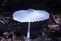 Agaricus mushroom
 -
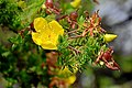 Wild flower
 -
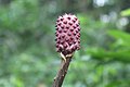
 Stinkhorn mushroom


Mount Cameroon National Park

Mount Cameroon National Park (Parc National du Mont Cameroun) was created in 2009. It covers an area of 581.23 km2.[10] The park includes the former Etinde Forest Reserve and most of the Bomboko Forest Reserve.[11] A portion of the Bomboko Forest Reserve remains outside the park, on the lower northern slopes of the mountain.[7]
IUGS geological heritage site
In respect of it being 'one of the few volcanoes in the world located at the ocean-continent boundary in a passive tectonic margin', the International Union of Geological Sciences (IUGS) included 'The Quaternary Cameroon Volcano' in its assemblage of 100 'geological heritage sites' around the world in a listing published in October 2022. The organisation defines an IUGS Geological Heritage Site as 'a key place with geological elements and/or processes of international scientific relevance, used as a reference, and/or with a substantial contribution to the development of geological sciences through history.'[12]
Access
The peak is frequently ascended by hikers. The annual Mount Cameroon Race of Hope scales the peak in around 4½ hours. Sarah Etonge has won the race seven times and is also a tour operator. English explorer Mary Kingsley, one of the first Europeans to scale the mountain, recounts her expedition in her 1897 memoir Travels in West Africa.
Gallery
-
 Mount Fako, left view
 -
 Top view at Mount Fako
 -
 Mount Fako
 -
 Summit at mount Cameroon
 -
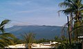
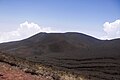
 Landscape of Mount Cameroon
 -
 View of the mountain from the base
 -
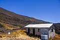
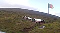 Accommodation facilities on Mount Fako
 -
 Ditto
Ditto -
 Ditto
Ditto -
Cameroon Mountain Race
-
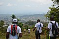 Hikers climbing down
 -
 View of Mount Etinde
 -
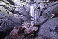 Mount Cameroon tropical rocks
 -
 Limbe Beach
 -
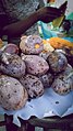 Grilled plums


.jpg)


See also
Notes
- SRTMdata, which shows no 3" cells higher than 4,027 m (13,212 ft) or 1" cells higher than 4,029 m (13,219 ft).
- ^ A hand-held GPS reading of 4,045 m (13,271 ft) was reported in 2015.[1] The elevation is subject to change due to volcanic activity.
- ^ "Mont Cameroun, Cameroon" Peakbagger.com. Retrieved 2012-09-30.
- ^ DeLancey and DeLancey 174. The authors do not give a precise year, but Merrick was active in Cameroon from 1844 to 1849.
- ^ "Mount Cameroon", Encyclopedia Britannica
- PMID 27713494.
- ^ a b c d e The Management Plan of the Mount Cameroon National Park and its Peripheral Zone, 2015 - 2019. The Ministry of Forestry and Wildlife, Republic of Cameroon.
- . Retrieved 18 November 2021.
- . Retrieved 18 November 2021.
- ^ "Mont Cameroun". Protected Planet. Accessed 15 June 2020
- ISBN 978-1-56973-789-7. [2]
- ^ "The First 100 IUGS Geological Heritage Sites" (PDF). IUGS International Commission on Geoheritage. IUGS. Retrieved 13 November 2022.
References
- DeLancey, M. W. and M. D. DeLancey. (2000). Historical Dictionary of the Republic of Cameroon (3rd ed.). Lanham, Maryland: The Scarecrow Press.
- "Cameroon". Global Volcanism Program. Smithsonian Institution. Retrieved 2009-01-14.
External links
| National | |
|---|---|
| Geographic | |