
Pizzo Coca
| Pizzo Coca | |
|---|---|
Alpine mountains above 3000 m | |
| Coordinates | 46°4′7″N 10°0′42″E / 46.06861°N 10.01167°E |
| Naming | |
| Native name | ol Coca (Lombard) |
| Geography | |
 Pizzo Coca Location in the Alps | |
| Location | Bergamo Alps |
Pizzo Coca (
Geology and orogeny
The Alps form a part of a
Climate
The Alps are split into five climate zones, each with a different kind of environment. The climate, plant life and animal life vary on different sections or zones of the mountain such as Pizzo Coca. The initial altitude at
Pizzo Coca's Subalpine regional climate ranges to 1,800 metres with the lower levels available for cultivation. The Alpine regional climate exists between 1,800 and 2,500 meters. The Glacial regional climate extends from 2,500 to Pico Coca's top at 3,050 metres with snow falling at the higher elevations.
Approach
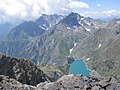
Pizzo Coca can be reached from the south starting from Valbondione. From here the path leads to Rifugio Coca,[2] a "hut"[12] managed by Club Alpino Italiano based in Bergamo, then continues towards Lago di Coca.[13][14] From here, before reaching the lake, climbers must crawl up the scree to the east. After this, the trail climbs quickly, then follows a semicircle along the natural amphitheatre at the foot of the Bocchetta dei Camosci.[13][14] From here begins the steepest part of the path allowing climbers, after 300 to 400 meters uphill, the base of Pizzo Coca is reached.
From the peak, there is an unrestricted view to the east and the surrounding area. The
The initial trail leads to a series of rifugios, which is Italian for refuges, like the first Rifugio Coca
Nearest services
Pizzo Coca's nearest airport is
See also
- Alpine Brigade Orobica
- Swiss Alps
- List of national parks of the Alps
Photo gallery
-
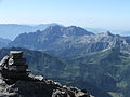
 Looking south Monte Torena from Pizzo Coca
 -
 Looking south Pizzo Strinato
 -
 Looking at Presolana
 -
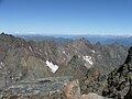 The crown view from Pizzo Coca
 -
 Pizzo di Coca


Sources
- Europe Ultra-Prominences www.peaklist.org Retrieved: 2010-05-11.
- "Pizzo Coca". Peakware.com. Archived from the original on 2016-03-04. Retrieved 2010-05-11.
- Pizzo di Coca A Google translation Retrieved: 2010-05-11
References
- ^ a b c d "Pizzo di Coca". Peakware.com. Archived from the original on 2016-03-04. Retrieved 2010-05-11.
- ^ a b c d e f "Pizzo di Coca-Punta Scaiss-Pizzo Redorta". summitpost.org. 2006. Retrieved 2010-05-11.
- ^ a b c Petter Bjørstad; Jonathan de Ferranti; Eberhard Jurgalski; Vasja Kavcic; Aaron Maizlish (2004). "Europe Ultra-Prominences". peaklist.org. Retrieved 2010-05-11.
- ^ a b c "Pizzo Coca: Cresta Est" (in Italian). camptocamp.org. October 19, 2008. Retrieved 2010-05-11.
- ^ a b c "Pizzo Coca: Cresta Est Google translation". camptocamp.org. October 19, 2008. Retrieved 2010-05-11.
- ^ a b c "The Orobie Park". turismo.provincia.bergamo.it. Archived from the original on 2010-06-30. Retrieved 2010-05-11.
- ^ "Parco delle Orobie Bergamasche". Consorzio Parco delle Orobie Bergamasche. turismo.provincia.bergamo.it. 2010. Retrieved 2010-05-11.
- ^ Giada Beccarelli (April 20, 2010). "Rifugio Coca" (in Italian). valseriana.bg.it. Archived from the original on September 2, 2010. Retrieved 2010-05-12.
- ^ Giada Beccarelli (April 20, 2010). "Rifugio Coca Google translation". valseriana.bg.it. Retrieved 2010-05-12.
- ^ a b c %5bundefined%5d Error: {{Lang-xx}}: no text (%5b%5b:Category:Lang and lang-xx template errors|help%5d%5d)%5b%5bCategory:Lang and lang-xx template errors%5d%5d "Pizzo Coca per il canalone NO (m 3050)". lemontagnedivertenti.com. June 22, 2008. Retrieved 2010-05-12.
{{cite web}}: Check|url=value (help) - ^ a b c "Pizzo Coca per il canalone NO (m 3050) Google translation". lemontagnedivertenti.com. June 22, 2008. Retrieved 2010-05-12.
- ^ a b c "Pizzo Coca". ii.uib.no. Retrieved 2010-05-12.
- ^ a b c "Pizzo Coca" (in Italian). webalice.it. Archived from the original on 2012-11-08. Retrieved 2010-05-11.
- ^ a b c "Pizzo Coca Google translation". webalice.it. Retrieved 2010-05-11.
External links
 Definitions from Wiktionary
 Media from Commons
 News from Wikinews
 Quotations from Wikiquote
 Texts from Wikisource
 Textbooks from Wikibooks
 Resources from Wikiversity
- Alpinfoto alpinfoto.it (in Italian) Retrieved: 2010-05-11. - Images from the Alps
- Alpine Convention www.alpconv.org Retrieved: 2010-05-11. - Convention on the Protection of the Alps
- Alpine Space Programme, Alpine Space ProgrammeRetrieved: 2010-05-11. - EU transnational co-operational programme for the Alps