
Beşparmak Mountains
| Beşparmak Dağı | |
|---|---|
| Mount Latmus | |
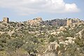
 Mount Latmus and the village of Kapıkırı among the ruins of Heracleia, with Lake Bafa in foreground. View is to the north. | |
| Highest point | |
| Elevation | 1,353 m (4,439 ft)at Tekerlek Tepesi, "the crest of the hub" |
| Coordinates | 37°29′53.19″N 27°31′36.51″E / 37.4981083°N 27.5268083°E |
| Naming | |
| English translation | Five-finger mountain/range |
| Language of name | Turkish language |
| Geography | |
 Beşparmak Dağı | |
| Parent range | Beşparmak Dağlari at the southern edge of the Menderes Massif[2] |
| Geology | |
| Mountain type | Ridge with multiple spurs, six major ones |
| Climbing | |
| Easiest route | Hike |
Beşparmak Mountains (
The mouth of the Gulf of Latmus began to fill with sediment from the
Beşparmak looms far beyond Kapikiri to the east for a total distance of about 35 kilometres (22 mi), 5 kilometres (3.1 mi) to 10 kilometres (6.2 mi) wide. It is deeply eroded by various streams into spurs. The spur that can be seen from Kapikiri is one Dağ, or "mountain", but the entire ridge with all the spurs is Dağlar, "mountains", in the sense of "range." The ancient writers generally recognized the western spur over the gulf as Latmus, but Strabo reports that the ridge east was called
Geology

The morphotectonic configuration of Anatolia and the Aegean is a result of continental drift movements associated with the Alpine orogeny, a zone of mountain-building caused by the collision of the African and Arabian Plates with the Eurasian Plate. The former have been slipping under the latter compressing and lifting the edge and creating zones of metamorphic rock from previous layers of sedimentary rock. These zones in the Aegean are represented by a number of massifs that were originally buried by crustal subduction: the Rhodope, Kazdag, Menderes, Cycladic Massif and Crete.
For various geologic reasons, modelled differently by different geologists, the zone of compression in the Aegean became one of extension: the region widened and dome-like or ovoid massifs were uncovered, or exhumed, from the subduction zones and rose by isostasy. In the case of the Menderes Massif, which is 40,000 km2 (15,444.1 sq mi), the reasons are better known due to geologic research in central Turkey. Anatolia is a triangular block created by the intersection in central Turkey of the North and East Anatolian faults. As the northward-pressing Arabian Plate pushes against this wedge the latter slips to the west but the broad end opens along fault lines like the rays of a fan, extending the massif to the north-northeast and south. This is being called a bivergent (diverges in two places) model.
The entire massif is divided or nearly so by a
The Graben are low-key
Except for alluvial fans of impermeable clay the rock is highly porous due to a network of small faults, which dips into the warmer regions below the surface. Warm springs and vapors are common, giving the appearance of volcanic activity. The ancients cross-culturally viewed these phenomena as being caused by divinities, which rock-paintings indicate they worshipped. The north slopes of Latmus are subject to heavy and damaging mudslides, which also would have contributed to the idea that it was a god.
Mythology
Latmus is probably alluded to by Homer, when he speaks of the mountain of the Phthirians, in the neighbourhood of Miletus.[9] Latmus appears in Greek mythology as the site of the cave where Selene's consort Endymion lies forever young and beautiful in blissful sleep.[10]
Prehistory
Beginning in 1994 about 170 rock paintings have been discovered in shallow caves and overhangs near springs at the foot of Mount Latmus overlooking Lake Bafa.[11] They came to light in a survey conducted by Anneliese Peschlow of the German Archaeology Institute.[12] Peschlow dates the earliest to about 6000 BCE and believes from other findings that the region has been continuously occupied since then. She is currently working to get Mount Latmus reserved as a national park.
The paintings, which are done entirely in red, depict mainly social and religious scenes. Different representations of the mountain include a dragon, indicating that it was worshipped as a god; that is, Latmus was a sacred mountain at least as early as the
A 2004 palynological study of two sediment cores taken from Lake Bafa near Kapikiri (Baf S1) and from the western depth (Baf S6) suggests a habitation sequence of the Büyük Menderes River valley and the shores of Latmus that appears to support the early history of the region. Baf S1, containing the oldest sediment, is layered in four subsections, the first carbon dated to before 4000 BCE.
From the pollen of subsection 1 a model can be constructed

Subsection 2, dated 1240/1126 BCE to 710/558 BCE, represents a settlement from the
The Lake Bafu profile shows the replacement of deciduous oak and pine with
Subsection 3 reveals an abandonment of the cleared areas, the decline of Olea, and the spread of Pistacia, Pinus brutia and Quercus coccifera (instead of deciduous oak) on formerly cleared land and in the maquis. As this is the time of the rise of Ionia, the palynological scenario suggests a movement of population from the land to the newly settled or expanded big cities of the Ionian League. Subsection 4 and Baf S6 go on to catalogue the return of the fruit trees, re-clearing the land for pasture, planting of rye and other cereals, ultimate destabilization of the soil through over-use, denudation and acceleration of sedimentation. After the sealing off of the bay to form the lake, population and land use declined to their current low levels around Latmus, but the river valley is cultivated.
History

Latmus became a member of the
The modern village of Kapıkırı is built among the ruins.The with a horseshoe-shaped rear wall partly cut out of the bedrock, with an entrance hall and columned forecourt.

A temple of Athena at Heracleia reveals its earlier foundation by not being aligned with the Hellenistic street pattern.
In
Iron ore was mined in the area as of the early 20th century.[24]
In 2018, four kilometers of the ancient stone road, which connects the ancient cities of
Gallery
-
 Herakleia at Latmus – Defensive towers
 -
 Herakleia at Latmus – Agora
 -
 Herakleia at Latmus – Stonework supporting the agora
 -
 Herakleia at Latmus – The temple of Athena viewed from the agora
 -
 Herakleia at Latmus – View towards Byzantine castle from temple of Athena
 -
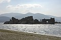 Herakleia at Latmus – Monastery on island in Lake Bafa
 -
 Herakleia at Latmus – Byzantine Castle
 -
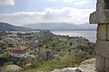
 Kapiri village with Lake Bafa in the background
 -
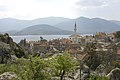
 Sakarkaya, Latmos Mountains, Turkey.


.jpg)
See also
Notes
- ^ Part of the spur along the lake is in Aydın Province as the border transects the lake but Herakleia and most of the mountain are in Muğla.
- ^ Not to be confused with the range of the same name in Cyprus.
- ^ uk:Латмійська затока
- ^ Turkish Milet, not to be confused with Turkish Milas.
- ^ a b Strabo. "Geography 14.1.8". Tufts University: Perseus Project. Retrieved 2008-02-10.
- ^ Iliad Book II line 868.
- ISBN 3540437118.
- S2CID 39468882. Retrieved 2008-02-25.
- ^ Homer. Iliad. Vol. 2.868.
- Valerius Flaccus, Argonautica 3.28; Pausanias (1918). "1.4". Description of Greece. Vol. 5. Translated by W. H. S. Jones; H. A. Ormerod. Cambridge, Massachusetts; London: Harvard University Press; William Heinemann – via Perseus Digital Library.
- ^ a b "Unique rock paintings reveal traces of prehistoric human settlement in Anatolia". Turkish Daily News. January 18, 2007.
- ^ Deutsches Archäologisches Institut. Archived July 16, 2007, at the Wayback Machine
- ISSN 0928-2734.
- ISBN 9061911389.
- Polyainos7.23.2 reports the capture of Latmos by Mausolos, and 8.53.4 by Artemisia as sole ruler.
- ^ The wall, originally with sixty-five towers (Princeton Encyclopedia of Classical Sites 1976), is one of the best-preserved urban fortifications of Antiquity.
- ^ The old city site became a necropolis.
- ^ The rectilinear grid of streets typical of Hellenistic foundations is traditionally credited to Alexander's architect Hippodamus of Miletus.
- Alexandria ad Latmum(Alexandria by Latmus) was identical to this Heracleia is still an open question, according to Getzel M. Cohen, The Hellenistic Settlements in Europe, the Islands, and Asia Minor. (Hellenistic Culture and Society, 17) (Berkeley: University of California Press) 1995: 245f; the city was called also called Pleistarcheia for a while (pp. 261-263).
- ^ Princeton Encyclopedia of Classical Sites 1976; see also P.M. Fraser, Cities of Alexander the Great (Oxford 1996:28-29) and A.W. McNicoll, Hellenistic Fortifications from the Aegean to the Euphrates (Oxford 1997:75-81).
- ^ Pausanias remarked "The Eleians and the Herakleians near Miletos tell different stories about Endymion's death; the Eleians show you Endymion's tomb but the Herakleians say he went away to Mount Latmos, where they honour him and have a holy place of Endymion." (v.1.5).
- ISBN 978-0-19-504652-6
- ^ Peter Levi, ed. Pausanias, Guide to Greece 1979:198 note 7.
- ^ Prothero, G.W. (1920). Anatolia. London: H.M. Stationery Office. p. 106.
- ^ Ancient road destroyed to make way for villagers’ olive groves in Aydın
![]() This article incorporates text from a publication now in the public domain: Smith, William, ed. (1854–1857). "Latmus". Dictionary of Greek and Roman Geography. London: John Murray.
This article incorporates text from a publication now in the public domain: Smith, William, ed. (1854–1857). "Latmus". Dictionary of Greek and Roman Geography. London: John Murray.
External links
- Cromwell, Bob (2008). "Mountain Treks in the Besparmak Mountains". Retrieved 2008-02-10.
- George, Roy (1998–2002). "Temple of Athena at Heracleia under Latmus". The Shrine of the Goddess Athena:Museum. Retrieved 2008-02-10.
- Keller, Don (1991). "Overall View of the Sanctuary of Endymion, from SW". Tufts University: Perseus Project. Retrieved 2008-02-10.
- Wolter, Felix. "Trekking Tour through the Latmos Mountains". utour.de. Retrieved 2009-12-06.
| Mountain ranges | |
|---|---|
| Mountains |
|
| International | |
|---|---|
| National | |
| Geographic | |