
Mount Moran
| Mount Moran | |
|---|---|
.jpg) Aerial view of Mount Moran from the east | |
| Highest point | |
| Elevation | 12,610 ft (3,840 m)[1] |
| Prominence | 2,605 ft (794 m)[1] |
| Coordinates | 43°50′07″N 110°46′35″W / 43.83528°N 110.77639°W[2] |
| Geography | |
 Mount Moran | |
class 5.4 | |
Mount Moran (12,610 feet (3,840 m)) is a
intrusion
known as the Black Dike.
Climbing
Mount Moran is a massive and impressive mountain which would make it attractive to mountaineers. However, the comparative difficulty of the approach to the climbs makes it a much less popular climb than the
String Lake, across Leigh Lake
and then pick their way to their respective route; but even this may require some overland route finding. As a result, most climbs on Mount Moran tend to take several days even when the technical portion of the climb is comparatively brief.
The first ascent of Mount Moran was made on July 22, 1922 by LeGrand Hardy, Bennet McNulty, and Ben C. Rich of the Chicago Mountaineering Club, via the Skillet Glacier route. It still provides perhaps the easiest and most direct route to the summit, and is
rated 5.4. As the name implies, most of the climb is on the steep snow and ice of Skillet Glacier, thus an ice axe and crampons
are used during the ascent.
The most popular route up Mount Moran is the CMC route, named for the Chicago Mountaineering Club. The CMC is
rated 5.5, and ascends the east face just south of the Black Dike. The CMC climbs good rock and is essentially free of snow and ice. It also has the advantage of a good camp high on the flank of the mountain.[5]
The Direct South Buttress, a
pitches. This route is featured in the historic climbing text Fifty Classic Climbs of North America,[6]
and was first ascended by Richard Emerson, Don Decker, and Leigh Ortenburger, August 30–31, 1953.
Climate
| Climate data for Mount Moran 43.8334 N, 110.7756 W, Elevation: 11,864 ft (3,616 m) (1991–2020 normals) | |||||||||||||
|---|---|---|---|---|---|---|---|---|---|---|---|---|---|
| Month | Jan | Feb | Mar | Apr | May | Jun | Jul | Aug | Sep | Oct | Nov | Dec | Year |
| Mean daily maximum °F (°C) | 19.4 (−7.0) |
18.6 (−7.4) |
23.4 (−4.8) |
28.4 (−2.0) |
38.0 (3.3) |
48.9 (9.4) |
59.3 (15.2) |
58.6 (14.8) |
49.5 (9.7) |
36.6 (2.6) |
24.7 (−4.1) |
18.7 (−7.4) |
35.3 (1.9) |
| Daily mean °F (°C) | 10.1 (−12.2) |
8.5 (−13.1) |
12.7 (−10.7) |
17.2 (−8.2) |
26.1 (−3.3) |
35.9 (2.2) |
45.1 (7.3) |
44.4 (6.9) |
36.2 (2.3) |
25.0 (−3.9) |
15.5 (−9.2) |
9.7 (−12.4) |
23.9 (−4.5) |
| Mean daily minimum °F (°C) | 0.8 (−17.3) |
−1.7 (−18.7) |
2.0 (−16.7) |
5.9 (−14.5) |
14.5 (−9.7) |
23.0 (−5.0) |
30.8 (−0.7) |
30.2 (−1.0) |
22.8 (−5.1) |
13.4 (−10.3) |
6.3 (−14.3) |
0.7 (−17.4) |
12.4 (−10.9) |
| Average precipitation inches (mm) | 8.88 (226) |
7.27 (185) |
7.04 (179) |
6.40 (163) |
5.43 (138) |
3.94 (100) |
1.53 (39) |
1.66 (42) |
2.97 (75) |
4.73 (120) |
7.37 (187) |
8.78 (223) |
66 (1,677) |
| Source: PRISM Climate Group[7] | |||||||||||||
History
On November 21, 1950, a DC-3C cargo plane owned by the
New Tribes Mission crashed on Mount Moran during a storm, killing all 21 on board. A rescue party organized by Paul Petzoldt located the wreckage on November 25, but the extreme location of the crash made it impossible to recover the plane or the bodies.[8] The wreckage remains on the mountain today, but the Park Service
discourages climbs to the site.
-
 Mount Moran summit with Falling Ice Glacier at left and Skillet Glacier at right
 -
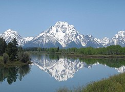 Mount Moran with the Snake River in the foreground
 -
 Mount Moran rises abruptly above Jackson Lake. Grand Teton can be seen in the background at left


See also
References
- ^ a b "Mount Moran, Wyoming". Peakbagger.com. Retrieved 2011-05-28.
- ^ "Mount Moran". Geographic Names Information System. United States Geological Survey, United States Department of the Interior. Retrieved 2011-05-28.
- ^ Mount Moran, WY (Map). TopoQwest / United States Geological Survey. Retrieved May 28, 2011.
- ^ "Hayden Expedition". Wyoming Tales and Trails. Retrieved 10 October 2010.
- ISBN 0-89886-480-1.
- ISBN 0-87156-292-8.
- ^ "PRISM Climate Group, Oregon State University". PRISM Climate Group, Oregon State University. Retrieved October 12, 2023.
To find the table data on the PRISM website, start by clicking Coordinates (under Location); copy Latitude and Longitude figures from top of table; click Zoom to location; click Precipitation, Minimum temp, Mean temp, Maximum temp; click 30-year normals, 1991-2020; click 800m; click Retrieve Time Series button.
- ^ "Rescuers Failed to Reach Downed New Tribes Plane". Christian History Institute. November 22, 1950. Archived from the original on April 4, 2005. Retrieved December 25, 2013.
External links
Wikimedia Commons has media related to Mount Moran.
- "Mount Moran" at Mountain Project
- "Mount Moran" at Summit Post
- Direct South Buttress" at Summit Post
- Mount Moran Photo Gallery of CMC route
- NASA Astronomy Photo of the Day - Great Fireball of August 10, 1972, over Mount Moran
- A climb of Mount Moran trip report with photos and video.