
Mount Pico
| Mount Pico | |
|---|---|
| Ponta do Pico | |
Ultra | |
| Coordinates | 38°28′08″N 28°23′56″W / 38.46889°N 28.39889°W[1] |
| Geography | |
 Mount Pico Location in the Azores, on the island of Pico  Mount Pico Mount Pico (Pico)  Mount Pico Mount Pico (Atlantic Ocean) | |
| Location | Pico Island, Azores |
| Parent range | Mid-Atlantic Ridge |
| Geology | |
| Age of rock | < 230,000 Years |
| Mountain type | Stratovolcano |
| Last eruption | July to December 1720[2] |
| Climbing | |
| Easiest route | Scramble, Class 2; YDS Grade II |
| Mount Pico Nature Reserve | |
|---|---|
ICNF |
Mount Pico (Portuguese: Montanha do Pico) is a currently quiescent stratovolcano located on Pico Island, in the mid-Atlantic archipelago of the Azores. It is the highest mountain in Portugal, at 2,351 metres (7,713 ft) above sea level, and is one of the highest Atlantic mountains; it is more than twice the elevation of any other peak in the Azores. It has been a designated nature reserve since 1972.
Eruptive history
Historical
On 29 September 2009 there were reports from local news sources that indicated that a fumarole existing at the pinnacle of the mountain (Piquinho) began emitting volcanic gas. The region's seismic and volcanological monitoring centre (Portuguese: CIVISA Centro de Informação e Vigilância Sismovulcânica dos Açores) indicated that the phenomenon occurred in the early morning, turning intense and visible in various points throughout the island and from Faial. Although the event resulted from exceptional meteorological conditions and was visible in the Central Group, there was no liberation of anomalous volcanic gases and all other parameters fell within norms.[6]
Geology
Mount Pico volcano is part of the Madalena Volcanic Complex, one of three volcanological units that comprise the island of Pico, associated with three historic eruptions in 1562, 1718 and 1720.[7] Current morphology suggests an age dating to the Holocene age, confirmed by radiocarbon dates younger than 6000 years.[7][8][9] Structurally, this complex can be subdivided into two other sections: the Pico Volcano and the East Fissural Zone.[7]
Pico is a stratovolcano (or composite), with a pit crater on its summit.
The tectonic structure is characterized by two fault systems.[7] The main WNW-ESE structures are the dextral faults of Lagoa do Capitão and Topo, that merge to the east, forming a narrow shallow graben (or trench).[7] To the west, the graben is completely covered by the Pico stratovolcano occurring less than 10,000 years ago, and infilled by lava flows and cones of the Eastern Fissural zone, that includes many of the volcanic alignments and scarps.[7] The second fault zone, running NNW-SSE, are markedly less in number and includes normal left lateral, oblique slip faults responsible for the main volcanic eruptions: the Lomba de Fogo-São João fault (basis of the 1718 eruption) and the Santo António volcanic alignment.[7]
On top of Pico (at Piquinho) there is an area of permanent degasification characterized by the emission of water vapour at a temperature of between 50 °C to 75 °C. In addition, other vents also exist between 1,500 metres (4,900 ft) and 2,000 metres (6,600 ft) above sea level, as well as diffuse degasification along the graben between the Lagoa do Capitão and Topo faults. There is also a carbon dioxide-rich spring in the locality of Silveira (along the southern coast of Lajes do Pico, formed in the base of Pico.
Observatory

Mount Pico's long
-
 Vegetated cavern on Mount Pico
 -
 The pit crater rim of Pico Alto on the summit of Pico volcano
 -
 The pinnacle of the mountain: Piquinho or Pico Pequeno
 -
 Mount Pico as it can be seen from Graciosa island (the air distance is about 70 km)
 -
 The landscape of the East Fissural Zone with some scoria cones.
 -
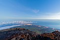 View of Madalena and Faial Island.
 -
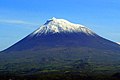 Snow on the mountain peak in early 2006.


.jpg)
See also
- List of European ultra prominent peaks
- Mons Pico
References
- Notes
- ^ a b c "Europe: Atlantic Island Ultra-Prominences". Peaklist.org. Retrieved 2014-05-23.
- ^ "Pico". Global Volcanism Program. Smithsonian Institution. Retrieved 2019-03-20.
- ^ "Montanha Do Pico". dopa-explorer.jrc.ec.europa.eu. Retrieved 14 June 2021.
- ^ "Montanha do Pico em alta nas visitas: horário de apoio às subidas vai ser alargado" (in Portuguese). Público. Retrieved 6 July 2021.
- ^ "Vulcão do Pico". INSTITUTO DE INVESTIGAÇÃO EM VULCANOLOGIA E AVALIAÇÃO DE RISCOS.
- ^ "Esclarecimento sobre a origem da coluna de vapor observada na Montanha do Pico". INSTITUTO DE INVESTIGAÇÃO EM VULCANOLOGIA E AVALIAÇÃO DE RISCOS. Retrieved 16 August 2020.
- ^ a b c d e f g h i José Madeira & António Brum da Silveira (October 2003), p.748
- ^ Madeira (1998)
- ^ Nunes (1999)
- ^ "Research in the North Atlantic Marine Air". Pico Mountain Observatory. Retrieved 6 July 2021.
- ^ Fialho, Paulo; Pacheco, José; Mazzoleni, Cláudio; Mazzoleni, Lynn; Henriques, Diamantino; Viveiros, Fátima (1 April 2019). "Pico Mountain Observatory on top of Pico Volcano". p. 18066. Retrieved 6 July 2021.
- ^ "Welcome to the Pico Mountain atmospheric observatory's website". pages.mtu.edu. Retrieved 6 July 2021.
- Sources
- Scarth, Alwyn; Tanguy, Jean-Claude (2001), Volcanoes of Europe, ISBN 0-19-521754-3
- Nunes, J.C. (1999), A actividade vulcânica na ilha do Pico do Plistocénio Superior ao Holocénio: Mecanismo eruptivo e hazard vulcânico. Tese de doutoramento no ramo de Geologia, especialidade de Vulcanologia (in Portuguese), Ponta Delgada (Azores), Portugal: University of the Azores
- Madeira, José (1998), Estudos de neotectónica nas ilhas do Faial, Pico e S. Jorge: uma contribuição para o conhecimento geodinâmico da junção tripla dos Açores. Tese de Doutoramento no ramo de Geologia, especialidade em Geodinâmica Interna (in Portuguese), Faculty of Sciences, University of Lisbon, pp. 428pp
- Madeira, José; Silveira, António Brum da (October 2003), "Active Tectonics and First Paleoseismological Results in Faial, Pico and S. Jorge Islands (Azores, Portugal)", Annals of Geophysics (PDF), vol. 46, Bologna, Italy: INGV, Istituto Nazionale di Geofisica e Vulcanologia, pp. 733–761