
Taurus Mountains
| Taurus Mountains | |
|---|---|
Mt. Demirkazık (3,756 m) | |
| Elevation | 3,756 m (12,323 ft) |
| Naming | |
| Native name | Toros Dağları (Turkish) |
| Geography | |
| Country | Turkey |
| Range coordinates | 37°N 33°E / 37°N 33°E |
The Taurus Mountains (Turkish: Toros Dağları or Toroslar, Greek: Ταύρος) are a mountain complex in southern Turkey, separating the Mediterranean coastal region from the central Anatolian Plateau. The system extends along a curve from Lake Eğirdir in the west to the upper reaches of the Euphrates and Tigris rivers in the east. It is a part of the Alpide belt in Eurasia.
Etymology
The mountain range under the current name was mentioned in The Histories by Polybius as Ταῦρος (Taûros). Heinrich Kiepert writes in Lehrbuch der alten Geographie that the name was borrowed into Ancient Greek from the Semitic (Old Aramaic) root טורא (ṭūrā), meaning "mountain".[1][2]
Geography
The Taurus mountains are divided into three chains from west to east as follows;
- Western Taurus (Batı Toroslar)
- Central Taurus (Orta Toroslar)
- Southeastern Taurus (Güneydoğu Toroslar)
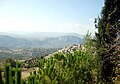
Western Taurus

The Western Taurus Mountains form an arc around the
-
 Termessos is an ancient city in the western Taurus
 -
 Antalya with the sunset and mountains in the west
 -
 Alanya, and the surrounding mountains


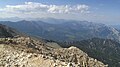
Central Taurus
The Central Taurus Mountains are roughly defined to include northern
) passes through it. Mountain ranges in the Central Taurus include:- Akçalı Mountains, western
- Bolkar Mountains, central, highest peak Mt. Medetsiz 3,524 m (11,562 ft)
- Aladaglar mountain range, central, highest peak Mt. Kızılkaya3,771 m (12,372 ft)
- Tahtalı Mountains or Anti-Taurus Mountains
- Munzur Mountains, eastern, highest peak Mt. Akbaba 3,462 m (11,358 ft)
- Mercan mountain range, within the Munzur
-

-
 Tahtalı Mountains
 -
 Gülek, Mersin Province
 -
 Railway viaduct, Adana Province
 -
 Near Mersin
 -
 Lake (Karagöl) near the summit


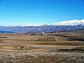
Southeastern Taurus
The Southeastern Taurus mountains form the northern boundary of the
-
 Malatya's Kale district and the Southeastern Taurus
 -


Geology
The Taurus Mountains were formed by the collision of the
Climate
The mountains have a Mediterranean climate, with dry summers and rainy winters. Temperatures vary with elevation, with warm winters on the lower coastal slopes and cold winters in the high mountains and in the interior.[5]
Flora and fauna
At lower elevations, the predominant vegetation forest and woodland of evergreen oaks and Turkish pine (Pinus brutia), and areas of maquis shrubland. Above 1200 meters elevation are montane forests of black pine (Pinus nigra), Lebanon cedar (Cedrus libani), Taurus fir (Abies cilicica), and juniper (Juniperus spp.). The high peaks are home to alpine meadows.[5]
History
Pre-history and early Roman period
The bull was commonly the symbol and depiction of
A
The Amanus range in southern Turkey is where the Taurus Mountains are pushed up as three tectonic plates come together. The Amanus is a natural frontier: west is
Late Roman period to present
During World War I, the German and Turkish railway system through the Taurus Mountains proved to be a major strategic objective of the Allies. This region was specifically mentioned as a strategically controlled objective slated for surrender to the Allies in the Armistice, which ended hostilities against the Ottoman Empire.[11]
Attractions
In addition to hiking and mountain climbing,.
The Varda Viaduct, situated on the railway lines Konya-Adana at Hacıkırı village in Adana Province, is a 98-metre-high (322 ft) railway bridge constructed in the 1910s by Germans.
See also
- Ark of Nuh or Noah
- Armenian highlands
- Karaca Dağ near Diyarbakır
- River system of Mesopotamia
- Zagros Mountains
References
- ^ "Toros". Index Anatolicus (in Turkish). Retrieved 1 February 2023.
- ^ İçel Sanat Külübü Aylık Bülteni, Ekim 1995 – 40. Sayı
- ^ a b c "Mountaineering in Turkey" All About Turkey
- ^ "Manavgat River Water as a Limited but Alternative Water Resource for Domestic Use in Middle East" (PDF). Archived from the original (PDF) on 2008-02-27. Retrieved 2008-02-16.
- ^ a b "Southern Anatolian montane conifer and deciduous forests". Terrestrial Ecoregions. World Wildlife Fund.
- ISBN 1-57506-069-8
- ISBN 0283996234
- ISBN 90-04-11864-0p. 91
- ^ "Amanus Mountains". Livius - Places. Livius.org - Jona Lendering. 26 March 2014. Retrieved 21 July 2015.
- ISBN 978-88-7653-143-9.
In the Second Temple period, when Jewish authors were seeking to establish with greater precision the geographical definition of the Land, it became customary to construe "Mount Hor" of Num 34:7 as a reference to the Amanus range of the Taurus Mountains, which marked the northern limit of the Syrian plain (Bechard 2000, p. 205, note 98.)
- ^ Price, Ward (16 December 1918) "Danger in Taurus Tunnels" New York Times
External links
- map of Eurasia showing Taurus Mountain ranges
| Mountain ranges | |
|---|---|
| Mountains |
|
| Geography |
|  | ||||
|---|---|---|---|---|---|---|
| History |
| |||||
| Languages | ||||||
| Culture / Society |
| |||||
| Archaeology | ||||||
| Religion | ||||||
| Academia | ||||||
| International | |
|---|---|
| National | |
| Geographic | |