
Mudanya
Mudanya | |
|---|---|
District and municipality | |
 View of Güzelyalı and Mudanya | |
 Map showing Mudanya District in Bursa Province | |
 Mudanya Location in Turkey  Mudanya Mudanya (Marmara) | |
| Coordinates: 40°22′35″N 28°53′00″E / 40.37639°N 28.88333°E | |
| Country | Turkey |
| Province | Bursa |
| Government | |
| • Mayor | Deniz Dalgıç (CHP) |
| Area | 369 km2 (142 sq mi) |
| Population (2022)[1] | 108,011 |
| • Density | 290/km2 (760/sq mi) |
| Time zone | UTC+3 (TRT) |
| Postal code | 16940 |
| Area code | 0224 |
| Website | www |
Mudanya (also: Mudania,[2] Greek: τα Μουδανιά, ta Moudaniá [Pl.]) (the site of ancient Apamea Myrlea) is a municipality and district of Bursa Province, Turkey.[3] Its area is 369 km2,[4] and its population is 108,011 (2022).[1] It is located on the Gulf of Gemlik, part of the southern coast of the Sea of Marmara. Between 1875 and 1948, it was connected with Bursa by the Mudanya–Bursa railway.[5] Mudanya has only an open anchorage usable in calm weather. The town produces olive oil and there is a pier used by local fishing and cargo boats.
History
According to the Ottoman General Census of 1881/82-1893, the
.jpg)
Liberation of Mudanya
Mudanya and its environs were liberated by the Turkish Kocaeli Army Corps under the Command of Halit (Karsıalan) Paşa on the 12th of September 1922.[8] The Greek 11th Infantry Division (Manisa Division) and the 45th &17th Infantry regiments along with their commanders and with Major-General Nikolaos Kladas were captured.[9]
.jpg)

The town was the signing place of the Armistice of Mudanya between Turkey, Italy, France and Britain on October 11, 1922, following the Turkish War of Independence.
After the
Composition
There are 47
- Akköy
- Altıntaş
- Aydınpınar
- Bademli
- Balabancık
- Çağrışan
- Çamlık
- Çayönü
- Çekrice
- Çepni
- Çınarlı
- Dedeköy
- Dereköy
- Eğerce
- Emirleryenicesi
- Esence
- Evciler
- Göynüklü
- Güzelyalı Burgaz
- Güzelyalı Eğitim
- Güzelyalı Siteler
- Güzelyalı Yalı
- Halitpaşa
- Hançerli
- Hasanbey
- Hasköy
- İpekyayla
- Işıklı
- Kaymakoba
- Küçükyenice
- Kumyaka
- Mesudiye
- Mirzaoba
- Mürsel
- Mütareke
- Ömerbey
- Orhaniye
- Söğütpınar
- Şükrüçavuş
- Tirilye
- Ülkü
- Yalıçiftlik
- Yaman
- Yaylacık
- Yenimahalle
- Yörükali
- Yörükyenicesi
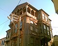
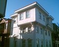
Traditional architecture in Mudanya
-
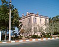
 The Armistice of Mudanya was signed in this Ottoman era building
 -
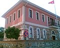 Ottoman era Governor's House in Mudanya
 -
 Ottoman era traditional building in Mudanya
 -
 Ottoman era traditional house in Mudanya
 -
 Ottoman era traditional house in Mudanya
 -
 Ottoman era traditional house in Mudanya
 -
 Ottoman era traditional house in Mudanya
 -
 Ottoman era traditional house in Mudanya
 -
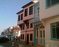
 Ottoman era traditional houses in Mudanya
 -
 Ottoman era traditional houses in Mudanya
 -
 Ottoman era traditional houses in Mudanya
 -
 Ottoman era traditional houses in Mudanya


See also
References
- ^ TÜİK. Retrieved 12 July 2023.
- ^ a b Prothero, G.W. (1920). Anatolia. London: H.M. Stationery Office.
- ^ Büyükşehir İlçe Belediyesi, Turkey Civil Administration Departments Inventory. Retrieved 12 July 2023.
- ^ "İl ve İlçe Yüz ölçümleri". General Directorate of Mapping. Retrieved 12 July 2023.
- ^ "Trains of Turkey | Main / HomePage". www.trainsofturkey.com.
- The University of Wisconsin Press, p. 132-133
- ^ "Zafer'den Kurtuluş'a… 12 Eylül 1922 Mudanya'nın Kurtuluşu". MUDANYA Gazetesi. 2022-09-11. Retrieved 2022-10-16.
- ^ "Zafer'den Kurtuluş'a… 12 Eylül 1922 Mudanya'nın Kurtuluşu". MUDANYA Gazetesi. 2022-09-11. Retrieved 2022-10-16.
- ISBN 9789754090598.
- ^ Mahalle, Turkey Civil Administration Departments Inventory. Retrieved 12 July 2023.
External links
- District governor's official website
- District municipality's official website
- Chisholm, Hugh, ed. (1911). . Encyclopædia Britannica. Vol. 18 (11th ed.). Cambridge University Press. p. 955.