Municipal Borough of Enfield
| Enfield | |
|---|---|
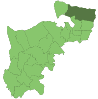
 Enfield within Middlesex in 1961 | |
| Area | |
| • 1911 | 12,601 acres (50.99 km2) |
| • 1961 | 12,400 acres (50 km2) |
| Population | |
| • 1901 | 42,378 |
| • 1961 | 109,542 |
| History | |
| • Created | 1850 |
| • Abolished | 1965 |
| • Succeeded by | London Borough of Enfield |
| Status | Urban district (1894 - 1955) Municipal borough (from 1955) |
| Government | |
| • HQ | Little Park, Gentleman's Row 1888 - 1961 Civic Centre, Silver Street 1961 - 1965 |
| • Motto | Priora Cole Meliora Sequere (Cherish the past but strive after even better things in the future) |
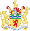
 Coat of Arms | |
Enfield was a local government district in Middlesex, England from 1850 to 1965.
History
The
Urban District.[1] Enfield Urban District Council replaced the local board, and was divided into four wards each returning three councillors: Town, Chase & Bull's Cross, Ordnance and Green Street & Ponders End.[2]
In 1909 two new wards, Bush Park and Hadley Wood & Cockfosters were formed and the UDC increased to 18 councillors.
[3]
The urban district council successfully petitioned for a charter of incorporation in 1955, becoming a
wards, each returning three councillors: Bush Hill Park, Cambridge Road, Chase, Enfield Wash, Green Street, Ordnance, Ponders End, Town, West and Willow.[1]
The borough was abolished under the London Government Act 1963 was merged with the Municipal Borough of Southgate and the Municipal Borough of Edmonton to form the London Borough of Enfield on 1 April 1965.
The borough included what is now known as Enfield Town, along with other settlements such as Brimsdown, Enfield Wash and Ponders End.
The urban district council was granted a
supporters, and a stag and an enfield were added on either side of the shield.[4] Much of the same symbolism was carried over to the new coat of arms of the London Borough of Enfield
when the London Borough was created.
References
- ^ a b Enfield - Local Government in ''Victoria County History of Middlesex, Vol.5 (British History Online), accessed January 28, 2008
- ^ Kelly's Directory of Middlesex 1899, p.110 (Historical Directories), accessed January 31, 2008
- ^ Kelly's Directory of Middlesex 1914, p.134 (Historical Directories), accessed January 31, 2008
- ^ Civic Heraldry of England and Wales - Enfield Borough Council, accessed January 28, 2008
