
Musandam Peninsula
|
جَزِيْرَة مُسَنْدَم رَأْس مُسَنْدَم | |
|---|---|
 The peninsula as seen from space. Al-Khasab to the north (top) shown in green, is contrasted between the more subtle rainbow tones of the surrounding rock in this false-colour image. The term Khasab refers to the fertility of the soil. | |
| Coordinates: 25°54′N 56°12′E / 25.900°N 56.200°E | |
| Governorates of Oman and Emirates of the United Arab Emirates | Musandam Governorate (Oman) Ras Al Khaimah (UAE) |
The Musandam Peninsula (
Arabic: رُؤُوْس ٱلْجِبَال, romanized: Ruʾūs al-Jibāl Heads of the Mountains),[3] is a peninsula that forms the northeastern point of the Arabian Peninsula. It is located to the south of the Strait of Hormuz, between the Persian Gulf and the Gulf of Oman.[4] It is inhabited by the Shihuh tribe and is mainly governed by Oman as the Musandam Governorate with certain parts governed by the United Arab Emirates, including Ras Al Khaimah and parts of Dibba.[1][2]
Climate, geology and geography
Land features include the
Arabic: رُؤُوْس ٱلْجِبَال, romanized: Heads of the Mountains).[1][2] The largest wadi in Mussandam is Wadi Bih, which forms the central drainage basin.[5][6]
The highest Mountain in Mussandam, and Ru'us al Jibal, is Jebel Harim, which measures 2,087 m (6,847 ft) from sea level.[7]
During winter, the region can be fairly cool, particularly the mountains of Jais, Yanas (
-
 View of the mountains of Musandam, December 1971
 -
 View of the Ru'us al-Jibal from Jabal Qiwhi
 -
 The mountainous area of Kumzar, c. 1908
 -
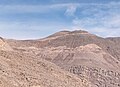
 Sedimentary rock layers near Khasab in Musandam Governorate, Oman
 -
 Jabal ar Raḩraḩ (1,676 m), the UAE's highest mountain, near Ras Al Khaimah

.jpg)


Fauna include the Ruus al Jibal fan-footed gecko,[10] Arabian tahr and caracal. It is unknown if the Arabian leopard is still present.[1][2]
-
 African monarch butterfly (Danaus chrysippus) in Zhighy Bay, Musandam Governorate
 -
 Blue basker dragonfly (Urothemis edwardsii)
 -
 Common mynah(Acridotheres tristis)
 -
 House sparrow (Passer domesticus)
 -

.jpg)
_Oman.jpg)
.jpg)
.JPG)
_(12801641984).jpg)
References
- ^ a b c d Edmonds, J.-A.; Budd, K. J.; Al Midfa, A. & Gross, C. (2006). "Status of the Arabian Leopard in United Arab Emirates" (PDF). Cat News (Special Issue 1): 33–39.
- ^ a b c d Spalton, J. A. & Al-Hikmani, H. M. (2006). "The Leopard in the Arabian Peninsula – Distribution and Subspecies Status" (PDF). Cat News (Special Issue 1): 3–47.
- ^ Thomas, B. (March 1927). Travels in Oman. Visit of B. Thomas to the Musandam Peninsula. 1928. Notes on Shihuh dialects & people, also Kumzaris' [10r]. British Library: India Office Records and Private Papers. p. 9.
- ^ Diba, B. A. (2011). Is Iran legally permitted to close Strait of Hormuz to countries that impose sanctions against Iran's oil?. Cupertino, California: Payvand Iranian-American Website.
- ISBN 978-3-1102-2339-2.
- ISBN 978-1-3172-9164-0.
- ^ "Jebel Harim". Wikimapia. Retrieved 15 March 2022.
- ^ Al Serkal, Mariam M. (2019-03-10). "UAE to see cold days ahead, temperatures drop to 2.6°C". Gulf News. Retrieved 2019-03-17.
- ^ Al Serkal, Mariam M. (2019-02-28). "UAE to get 5 days of rain and "significant drop in temperature"". Gulf News. Retrieved 2019-03-17.
- PMID 28767644, e0180397